Historic US highway endpoints in Santa Fe, NM
|
1927-1974
|
 |
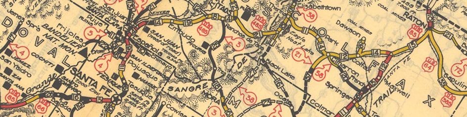
At first glance, I-25's route through New Mexico seems kind of strange. Southbound from Las Vegas, the highway turns west, and then northwest towards Santa Fe, before finally curving back to the south. Primarily this is for geographic reasons: mountains and mesas in that area stand in the way of a more direct route to Santa Fe. But it is also somewhat political: if there were no important city in Santa Fe's location, then I-25 probably would have been built along a more direct route between Las Vegas and Albuquerque.
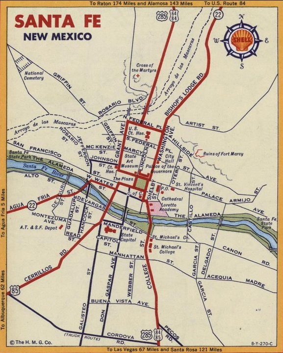
But, given the mandate to serve Santa Fe, I-25 does follow the shortest route possible: it skirts the south edge of the city, missing the downtown area by about three miles. I-25's precursor (US 85) went even further north -- all the way to the Plaza -- before turning back south again. Coming down from Glorieta Pass, I-25 veers away from the historic corridor of US 85 at about exit 284. From there, southbound US 85 continued north on College Street (now called Old Pecos Trail), and then Old Santa Fe Trail nearly due north, all the way into downtown. At the Plaza, traffic turned west on San Francisco Street for two blocks, then back south again on Galisteo Street, and out of town via Cerrillos Road: an amazingly circuitous route.
Now that we have established the original routing of US 85, we should observe that this was also the route of US 66. Until it was rerouted in 1937, US 66 and US 85 were concurrent from near Las Vegas to beyond Albuquerque.
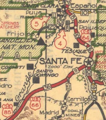
Now we can finally get to the main topic of this page: other US highways that terminated at their junction with US 85. When the US route system began in 1926, US 64 made it only as far west as Raton NM. The road from Raton through Taos and Espanola to Santa Fe was designated US 485 (it connected with US 85 on both ends):
But, given the mandate to serve Santa Fe, I-25 does follow the shortest route possible: it skirts the south edge of the city, missing the downtown area by about three miles. I-25's precursor (US 85) went even further north -- all the way to the Plaza -- before turning back south again. Coming down from Glorieta Pass, I-25 veers away from the historic corridor of US 85 at about exit 284. From there, southbound US 85 continued north on College Street (now called Old Pecos Trail), and then Old Santa Fe Trail nearly due north, all the way into downtown. At the Plaza, traffic turned west on San Francisco Street for two blocks, then back south again on Galisteo Street, and out of town via Cerrillos Road: an amazingly circuitous route.
Now that we have established the original routing of US 85, we should observe that this was also the route of US 66. Until it was rerouted in 1937, US 66 and US 85 were concurrent from near Las Vegas to beyond Albuquerque.
Now we can finally get to the main topic of this page: other US highways that terminated at their junction with US 85. When the US route system began in 1926, US 64 made it only as far west as Raton NM. The road from Raton through Taos and Espanola to Santa Fe was designated US 485 (it connected with US 85 on both ends):
c. 1931, NMDoT
|
US 485 came into Santa Fe via Taos Highway and Grant Avenue. Beyond there, it gets a little tricky: even maps from the 1930s show US 485 using multiple roads to reach US 85 at the Plaza:
|

c. 1934, Rand McNally
|
Possibly that was because one-way roads had already been established in Santa Fe back then. In general one-ways were not very common in the 1930s, but Santa Fe may have been an exception: it is a very old city, and many of the central streets are quite narrow. To this day, it is much easier to walk around downtown than to drive.
|
It is possible that southbound US 485 continued down Grant to Palace Avenue; then east two blocks; then south on Lincoln Avenue, skirting the west side of the Plaza, and ending at San Francisco (US 85). But northbound US 485 may have run along the east side of the Plaza. These photos will help to explain; this first one is looking north on Old Santa Fe Trail (which was southbound US 85):
|
Sanderson, June 2006
|
The small trees visible at far left are in the east side of the Plaza. (Between those and the large tree in the background, part of the Palace of the Governors is visible: now a historical museum, but previously the original Capitol, back when Santa Fe was still a part of Mexico.) If a driver were to follow Old Santa Fe Trail's slight jog to the left and continued straight ahead, they would have been on the south beginning of US 485. (That appears to have followed Washington Avenue north to Paseo de Peralta [nee Federal Place, nee Temple Place]; then west to Grant; then north out of town via Old Taos Highway.)
|
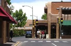
Southbound US 85 continued by turning left here on San Francisco. If one were to do that today, they would see what is pictured in this photo:
|

Sanderson, June 2006
|
|
There the view is west on San Francisco, or still southbound on US 85. Just to the right of the camera is the south side of the Plaza. Southbound US 485 would have come in from the right, on Lincoln. If one were to turn around from that spot, they would have a view similar to what is shown here:
|
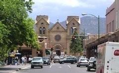
Sanderson, June 2006
|
|
That was looking east on San Francisco, or historic northbound US 85 (in the distance is the St. Francis Cathedral). Southbound US 485 came in from Lincoln (off to the left of the camera). At the traffic light ahead, northbound US 85 went right on Old Santa Fe Trail, while northbound US 485 departed to the left. But that was the case only for a few years: in about 1932, the US 64 designation was extended southwest from Raton to Santa Fe, replacing what had been US 485:
|
c. 1934, NMDoT
|
|
So for the next 20+ years, US 64's west end and beginning were the same locations described above. In 1936 US 285 was commissioned to run through Santa Fe, and then US 84 was extended through town in 1938. So after that time, for travelers heading north past the Plaza, signage would have looked something like what was shown in this 1963 photo:
|
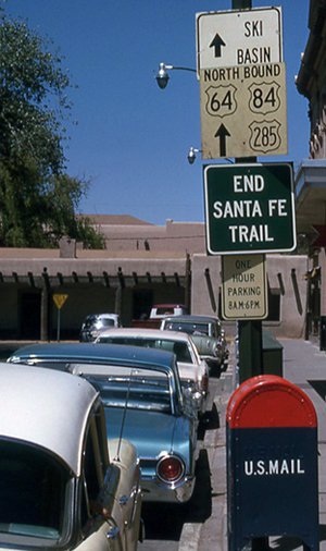
c. 1963, attribution unknown
|
|
The Plaza is off the left edge of the photo; ahead is part of the Palace of the Governors. This was the beginning of US 485, and then of US 64.
When US 66 was changed to run directly from Santa Rosa to Albuquerque in 1937, the US 84 designation was extended along the former US 66, ending in Santa Fe. And after a couple-year extension to Cortez CO, which was possibly never signed, US 84 again ended in Santa Fe in 1940: |
c. 1938, NMDoT
|
|
It likely ended on the Plaza, at the same place where US 64 began. But by 1941 US 84 had been permanently extended north from Santa Fe; this map illustrates the situation after that point:
|
c. 1951, Gousha
|
|
But in about 1954, Santa Fe built a new preferred entrance from the north. Instead of the Old Taos Highway, traffic was directed to use Jefferson Street (now called Guadalupe Street):
|

c. 1956, Gousha
|
|
At Water Street, US 64 turned east (drivers cannot do that anymore: Water was vacated between Guadalupe and Sandoval Street, where the Hilton stands now). US 64 ended one block past Sandoval, at Galisteo (US 85). Here we are looking east on Water:
|

Sanderson, June 2006
|
|
The car is stopped at the historic end of US 64 -- southbound US 85 was to the right on Galisteo, and northbound went left for one block before turning east on San Francisco. This view is to the north on Galisteo:
|
Sanderson, June 2006
|
|
That was northbound US 85, and the west beginning of US 64 was to the left on Water. This last photo is looking west on Water:
|

Sanderson, June 2006
|
The crossroad ahead is Galisteo, and on the far side of that was the beginning of US 64 (it used to go straight through where the building now stands in the background). This was the highway situation that was in place when the 1963 photo above was taken. So by that time, the US highway signs shown in that photo were actually referring to what had by then become the Business Loop along Old Taos Hwy. In 1974, US 64 was rerouted such that it no longer directly serves Santa Fe, and now no US routes terminate there.
Research and/or photo credits: Robert Droz; Alex Nitzman; Dale Sanderson
Page originally created 2006;
last updated Aug. 31, 2019.
last updated Aug. 31, 2019.
