End of US highway 70 |
 |
Summa
|
Summa
|
|
1926-1931
|
1931-1932
|
1932-1934
|
|
1934-1964
|
1963-1969
|
1969-present
|
|
Mileage: in 1989 AASHTO listed a figure of 2728 miles for US 70... however, that included the mileage of US 70's associated business/bypass/alternate routes, and it also included the mileage of US 70N and US 70S in Tennessee. According to the state subtotals on AASHTO's 1989 spreadsheet, mainline US 70's actual end-to-end total at the time was 2385 miles. That is reasonably close to our own 2020 measurement, which yielded 2365.6 miles (reroutings and realignments likely explain the difference). That puts the midway point of US 70 at Glenwood AR.
|
When US 70 went all the way to California, we estimate it was 2843 miles long, and at that time its midpoint would have been at Ardmore OK. However, AASHO's 1955 route log listed US 70 at 2926 miles, and that figure was used on this late-1950s promotional postcard:
|
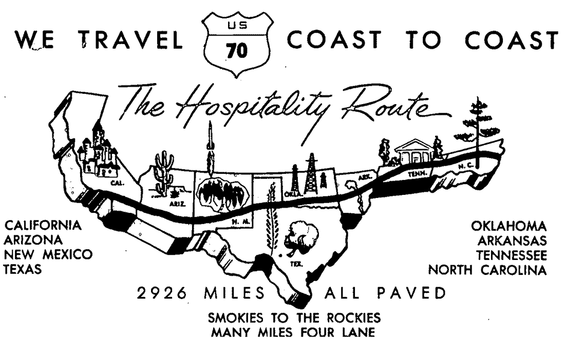
c. 1958, US Highway 70 Association
US 70 was an original 1926 route, but at the time its west end was in Holbrook. West of Clovis NM, US 70 followed an incredibly tortured route to get there. Perhaps that is why in 1931 the west end was truncated at Clovis and instead extended to El Paso. And already by 1934 US 70 had been extended all the way to Los Angeles (more info on those pages).
|
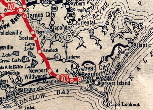
The east end of US 70 during its nascent years was in Beaufort. As this map shows, initially there was no bridge between Beaufort and Morehead City, so US 70 followed NC hwy. 10 all the way to Beaufort...
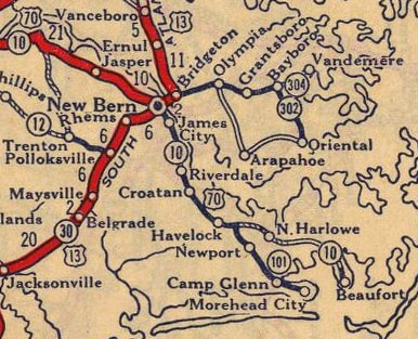
c. 1927, Rand McNally
|
...but by 1928, US 70 had been rerouted to use old NC 101 through Morehead City, then crossing over to Beaufort.
c. 1934, Gallup
|
|
(That second map also shows that NC 10 had been extended eastward to the town of Atlantic; that became the easternmost segment of US 70 a couple years later.)
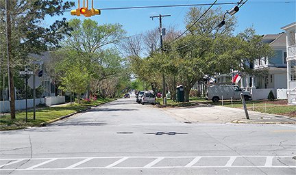
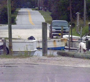
At the time, US 70 traffic came into Beaufort from Morehead via Ann Street (which is two blocks south of today's US 70). The US 70 designation ended at the intersection of Live Oak Street. In this photo, the view is west from Live Oak along Ann: |
Karners, Apr. 2014
|
|
The original east beginning of US 70 was to the right, on Live Oak. But after two years, US 70 began straight ahead. (Today, two blocks to the right is where modern US 70 turns from Cedar Street to Live Oak.)
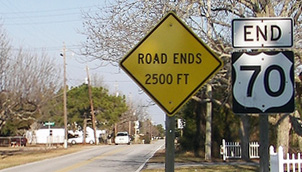
That did not last long, because by 1932 US 70 had been extended further east, to the town of Atlantic. Here is a photo of its current endpoint there: |

Hamilton, Aug. 2000
|
There, Alan had just finished driving the entire highway from end to end. More recently, a "Road Ends" sign has been added:
|
Babyak, Jan. 2008
|
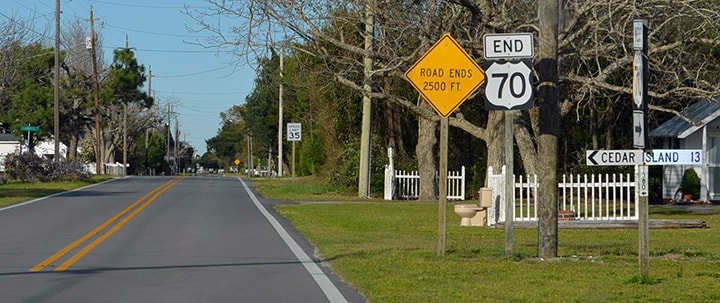
Johnson, Aug. 2017
|
|
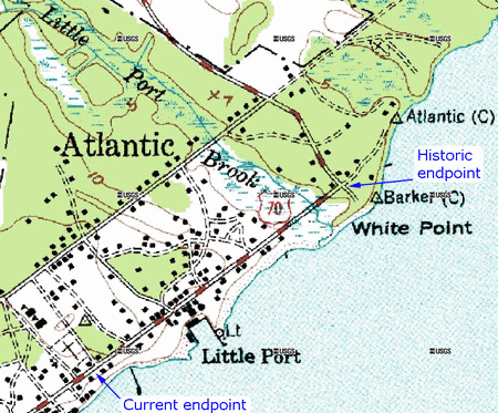
For decades, and until about 1976, US 70 continued another half-mile or so further ahead on Seashore Drive, including a bridge across Little Port Brook. The USGS topo shown here was made in 1949. The aerial photo is from approximately 2007. The topo map was made back when US 70 reached its maximum eastward extent: across Little Port Brook, to the Old Cedar Island road. But the aerial photo shows how the mouth of Little Port Brook has since been dredged out for a marina, and there is no longer a bridge where US 70 formerly crossed:
|
|
|
So historically, the route extended as far as what was then called Old Cedar Island Road. This was the original Atlantic endpoint of US 70, and the highway's maximum extent to the east (although from here traffic could continue left, northward to the Cedar Island-Okracoke ferry landing):
|
Karners, Apr. 2014
|
|
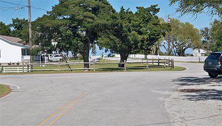
Today the road to the left becomes Old Cedar Island Road, but the name of the short segment between here and Shell Road has been changed to Core Sound Loop Road, reflecting the fact that this area is more of a dead-end now. The bridge was likely removed when the marina was created, and replacing it was probably deemed an unnecessary expense, since there was already another bridge over Little Port Brook (Shell Rd), which is how traffic is directed to reach Cedar Island today. This photo shows the same junction, approaching from Cedar Island:
|
Montgomery, Oct. 2010
|
|
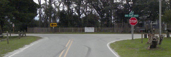
Historically US 70 began to the right. Today if one turns that direction, they are immediately greeted with a "Dead End" sign...
|
Karners, Apr. 2014
|
|
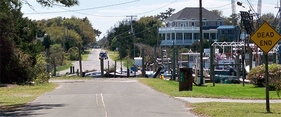
...although it is plain to see how the road aligns with another road on the far side of the marina:
|
Montgomery, Oct. 2010
|
|
Before the marina, it was just a creek that ran through there, and there was formerly a bridge that carried US 70 traffic across. Today, however, one must go north to Shell Rd, then west across Little Port Brook. At the intersection with NC hwy. 1380 (known locally as School Drive), the sign shown here is posted:
|
Montgomery, Oct. 2010
|
|
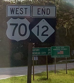
That is how Cedar Island traffic is directed to US 70 today. About a quarter-mile to the left, the current east beginning of US 70 is posted thus:
|

Montgomery, Oct. 2010
|
|
This next photo shows not only that sign, but also the "End" assembly we have already seen above:
|
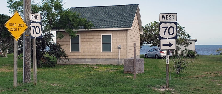
Head, Aug. 2019
|
|
That photo illustrates how close this endpoint is to Core Sound, and on the horizon the Core Banks are visible. On the same post as the "West 70" sign there is also a sign for Cedar Island traffic, shown close-up here:
|
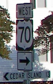
Babyak, Jan. 2008
|
|
Historically, if a driver were to take that right turn, they would be immediately greeted with a confirming assembly marking the east beginning of US 70:
|
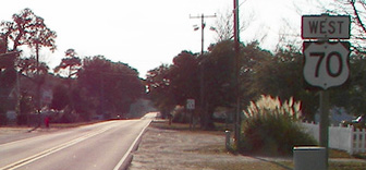
Babyak, Jan. 2008
|
|
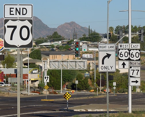
Globe, Arizona: 2366 miles...
...however, as of 2019 that assembly was gone, and in its place was a sign marking the Outer Banks National Scenic Byway. So then the first reassurance marker was not posted for nearly five miles: |
Head, Aug. 2019
|
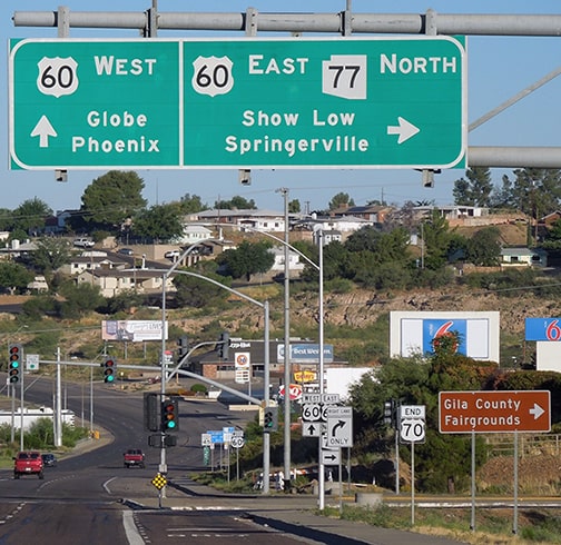
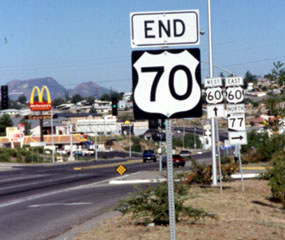
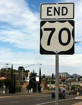
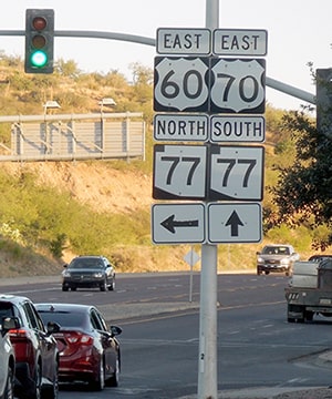
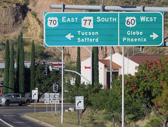
In 1934, the US 70 designation was removed from the segment between Alamogordo NM and El Paso (today's US 54) and re-routed through Las Cruces and beyond, along a path that closely resembles modern US 70... except it continued past Globe, all the way through Arizona and southern California, ending in Los Angeles. But after about 30 years, US 70 lost its status as a coast-to-coast route, because the designation was removed from California in 1963. For the next five years it ended unceremoniously in Blythe or at the state line nearby, but in 1969 the overlap with US 60 in Arizona was deemed unnecessary, so US 70 was truncated to its current terminus in Globe:
|
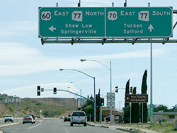
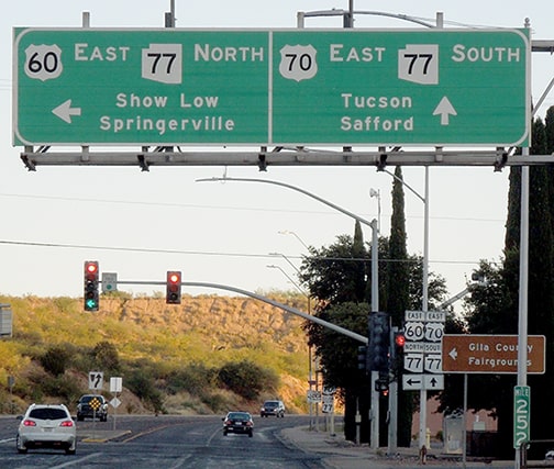
These shots were taken from westbound US 70, showing the last US 70 marker, and the overhead signage approaching its endpoint:
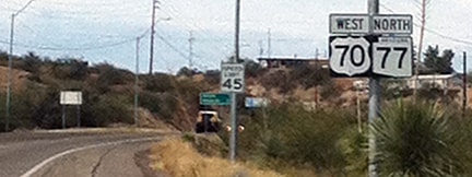
Schecter, Oct. 2016

Elbert, Apr. 2008
|
Sanderson, Oct. 2023
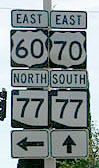
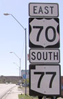
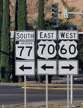
In that last photo, some ground-mounted signs are visible in the middleground; those are shown close-up in the photos below:
|
McClendon, 1999
|
Schecter, Oct. 2016
|
Schecter, Oct. 2016
|
Sanderson, Oct. 2023
|
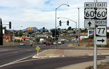
US 70 comes into Globe heading northwest from Safford; it is routed onto East Ash Street. Meanwhile, US 60 comes in heading southwest from Show Low. Where it intersects Ash, US 60 traffic is directed to turn right (west), continuing along Ash into downtown Globe. That is the intersection where US 70 now ceases to exist, as indicated by the assemblies shown there.
This next series of photos was taken from eastbound Ash: |
Ballard/Field/Jakab/Trinkle, Nov. 2006
|
Sanderson, Oct. 2023
|
|
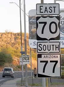
US 60 traffic continues by turning left; straight ahead is the west beginning of US 70. The ground-mounted signage ahead at the intersection is shown close-up here...
|
Ballard/Field/Jakab/Trinkle, Nov. 2006
|
Sanderson, Oct. 2023
|
|
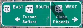
...and just beyond the traffic signal is the first eastbound US 70 confirming assembly:
|
Elbert, Apr. 2008
|
Sanderson, Oct. 2023
|
|
These photos show the overhead signage from westbound US 60...
Elbert, Apr. 2008
|
Sanderson, Oct. 2023
|
|
...which continues to the right on Ash. To the left is the west beginning of US 70. The ground-mounted assembly visible in the background is shown close-up here:
|

Elbert, Apr. 2008
|
Sanderson, Oct. 2023
|
Research and/or photo credits: Joe Babyak; Mike Ballard; Chris Elbert; Andy Field; Alan Hamilton; Mike Head; Levente Jakab; David Johnson; Karin and Martin Karner; Dennis McClendon; David Montgomery; Adam Prince; Mike Roberson; Dale Sanderson; James Schecter; Michael Summa; Kevin Trinkle
Page originally created 2000;
last updated Dec. 17, 2023.
last updated Dec. 17, 2023.
