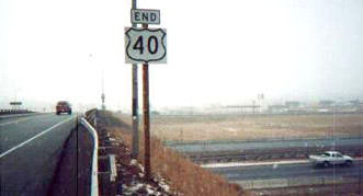
End of US highway 40 |
 |
Summa
|
Summa
|
Summa
|
Summa
|
|
1926-1932
|
1932-1963
|
1963-1975
|
1975-present
|

Mileage: in 1989 AASHTO listed a figure of 2372 miles for US 40... however, that included the mileage of US 40's associated business/scenic/alternate routes. According to the state subtotals on AASHTO's 1989 spreadsheet, mainline US 40's actual end-to-end total at the time was 2298 miles. That closely matches our own 2020 measurement, which yielded 2297.4 miles. That puts the midway point of US 40 near Concordia MO.
|
When US 40 went all the way to California, it was 3054 miles long, and at that time its midpoint was between Collyer and Quinter KS.
|
|
The east end of US 40 has been on the Jersey Shore since the US routes were first commissioned in 1926; more info on the Atlantic City page. Originally the west end of US 40 was in Oakland CA. It was extended to San Francisco in 1932, a few years before the Bay Bridge opened to traffic in 1936. Those historic endpoints are detailed on the Bay Area page.
US 40 ended in California for about 40 years, but in 1963 Caltrans requested to eliminate the designation from their state; signage was removed by 1967. For the next decade or so, the official west terminus was in Truckee (although most likely CalTrans removed US 40 signage all the way to the Nevada state line, since it was concurrent with I-80). Then in 1975 US 40 was officially removed from the rest of California, plus Nevada and most of Utah as well. Following is that agenda item from the minutes of AASHTO's meeting that took place in June of that year:
|
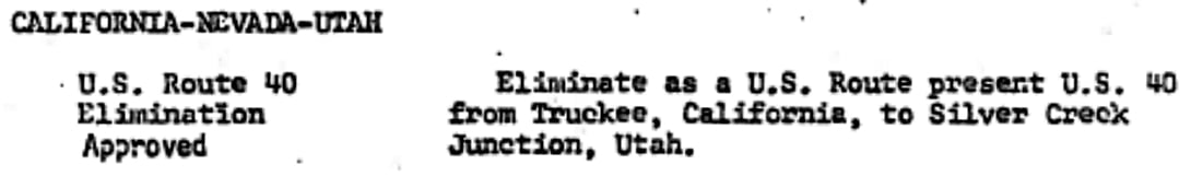
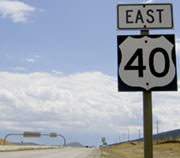
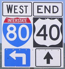
Since then the west terminus of US 40 has been at a place called Silver Creek Junction, which is along I-80 on the outskirts of Park City. That truncation happened right during the same timeframe when this photo was taken:
|
c. 1975, UDoT
|
|
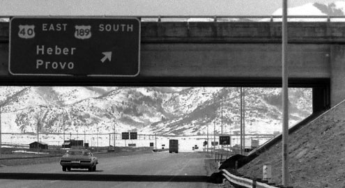
That was taken from westbound I-80. (Incidentally, note the reference to US 189; more on that below.) At the time, that interchange was numbered 148, but that exit number was affected when UDoT recalculated the mile markers along its interstates. This is now interchange 146, and here is a more recent photo from the same perspective:
|
Field/Nitzman, Sep. 2005
|
|
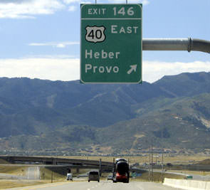
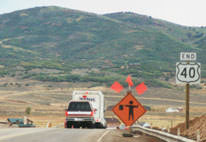
Historically, drivers heading west on US 40 would have seen the "End" assembly shown in this photo (the white pickup was heading east on I-80):
|
Stober
|
|
In 2000 (a few years after that photo was taken), that interchange was undergoing major reconstruction. This photo was from basically the same vantage point as the shot above...
|
Taylor, 2000
|
|
...but it was not long afterwards that this junction was significantly changed: the interchange now has flyover ramps. Here we were looking the opposite direction (east on I-80):
|

Sanderson, Oct. 2005
|
|
If one takes that exit to the right, the first eastbound confirming marker is posted where the roadway straightens out:
|
Field/Nitzman, Sep. 2005
|
|
The westernmost 12 miles of US 40 is now a freeway, all the way down to U-32 near Heber City. Signage for the first eastbound exit (Silver Summit) is barely visible in the distance. The frontside of the sign bridge at far left is shown in this photo. It is interesting that a westbound US 40 marker was posted within sight of the west end of the designation:
|
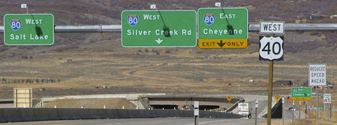
Sanderson, Oct. 2005
|
|
At that point, US 40 traffic wanting westbound I-80 to Salt Lake has already been directed along the opposite side of the concrete barrier at far left, and will use the flyover visible in the distance. However, if one gets on US 40 from the Silver Summit interchange, they are not allowed to cut across traffic to get to the flyover. Instead, drivers must continue straight ahead towards Silver Creek Road. Near the big green sign at far right (which directs east I-80 traffic to the right), there is a gore in the roadway, in which this assembly was posted:
|
Sanderson, Oct. 2005
|
|
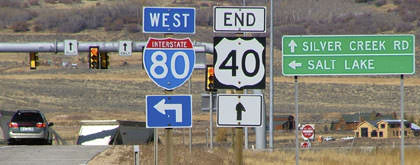
At the time, that was a new "End US 40" sign, but it did not last long... it had already been replaced by 2010...
|
Elbert, July 2010
|
...and in 2017 a reference to US 189 was added, which was an important milestone (for the reason why, see the US 189 page).
|
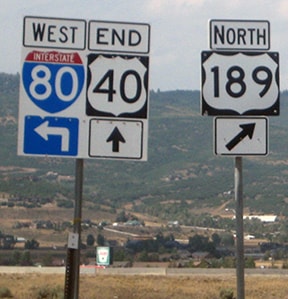
Rand, Aug. 2018
|
For the first ten years of its existence, there was a significant split in the route of US 40. West of Manhattan KS, US 40-N followed what is now US 24 to Limon CO (until 1936). Today's US 40 follows what used to be US 40-S between Manhattan and Limon.
And it gets even more interesting: at Limon was the west terminus of US 40-N, and US 40 continued west through Denver as it does today. But there was still a US 40-S to the west of Limon*. It followed what is now US 24 through Colorado Springs and to Minturn CO. From there, US 40-S followed what would later become US 6 (better known today as I-70) to Grand Junction, where the designation ended at its junction with US 50. In other words, the west segment of US 40-S did not reconnect with mainline US 40. More info can be found on the Grand Junction page.
This situation lasted until 1935 or 1936; at that point, the US 24 designation was extended west of Kansas City along its present route. In other words, it replaced US 40-N between Manhattan and Limon, and it followed the former US 40-S from Limon to Grand Junction. US 40-S from Manhattan to Limon became simply US 40.
* It remains unclear whether there were actually two separate routes called "US 40-S" (each heading opposite directions from Limon), or whether US 40-S was a single route, overlapped with US 40 along a four-mile stretch through Limon.
Research and/or photo credits: Chris Elbert; Tom Fearer; Andy Field; Alex Nitzman; Charles Rand; Dale Sanderson; Dan Stober; Michael Summa; Steven Taylor
Page originally created 2000;
last updated Dec. 16, 2023.
last updated Dec. 16, 2023.
