All about single-state US highways |
 |
Many of us are familiar with a recurring joke that is often framed as a question, but is actually more of a commentary: "Why are there interstate highways in Hawaii?" After all, at first glance it seems illogical that there would be an interstate which exists only in a single state, despite the fact that its very name indicates that it should cross a state boundary.
|
The same question can be raised with regard to intra-state US highways, i.e. US routes that exist only in a single state. As the logic goes: if the system was devised in order to facilitate inter-state travel, then what would be the point of intra-state US highways? Shouldn't those kinds of roads be classified as state highways?
|
|
The short answer is that both classifications (Interstate highways and US highways) were envisioned as a network of routes that would support the majority of travel throughout the country... keeping in mind that some important connecting routes would be entirely within one state. One of the prime examples is Interstate 45, which connects Dallas and Houston, and therefore obviously exists only in Texas. It would be difficult to make a convincing argument that the 4th- and 5th-largest metro areas in the U.S. should not be linked by an interstate highway.
The same rationale applies to the Interstate system's predecessor, the US highway system. The US routes served as the nation's original "inter-state" network, created to aid travelers by providing a unified numbering scheme that was consistent across state lines. Nevertheless, some important connecting routes were located entirely within a single state, so they were included in the US route system.
One can certainly disagree with that rationale and perhaps build a good case against it. But let it never be said that the US highway system was not intended to include intra-state routes, because that is simply not true.
One can certainly disagree with that rationale and perhaps build a good case against it. But let it never be said that the US highway system was not intended to include intra-state routes, because that is simply not true.
Intra-state US routes have been around since the very beginning.
|
If we look at the US highways that were proposed in 1925 by the BPR/AASHO Joint Board, 50 out of 146 routes were single-state (34% of the total). Most of those ended up being included among the 1926 inaugural routes (i.e. those that were officially commissioned). Plus, 20 more were added to that final list: on AASHO's first route log, we find no less than 71 original US routes were intra-state. So out of a total of 182 original routes, 39% were single-state. Included in that number were 12 two-digit US routes (which is somewhat surprising when one considers the fact that two-digit numbers were supposedly reserved for the longer routes in the system). Following is the full list of original 1926 intra-state US routes:
Bold = still intra-state today * = probably never signposted |
|
28 (OR)
42 (OH) 48 (CA) 49 (MS) 53 (WI) 68 (KY) 74 (NC) 76 (SC) 92 (FL) 94 (FL) 95 (ID) 96 (TX) |
102 (MI)
106 (PA) *109 (NY) 110 (WI) 116 (WY) 118 (WI) 120 (PA) 124 (IL) 129 (GA) 130 (NJ) 131 (MI) 141 (WI) |
150 (IN)
151 (WI) 154 (KS) 161 (IA) 166 (KS) 168 (KY) 171 (LA) 181 (TX) 185 (WY) 187 (WY) 190 (LA) 192 (FL) |
201 (ME)
209 (PA) 210 (MN) 211 (VA) 213 (MD) 222 (PA) 230 (PA) 231 (AL) 266 (OK) *270 (TN) 290 (TX) 295 (WA) |
309 (PA)
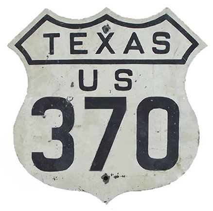
320 (WY) 330 (IL) 341 (GA) 350 (CO) 370 (TX) 395 (WA) 401 (VA) 411 (VA) 420 (WY) 422[e] (PA) 430 (IL) |
441 (FL)
470 (NM) 485 (NM) *511 (TN) 530 (UT) 550 (CO) 566 (NM) 601 (SC) 611 (PA) 650 (CO) 830 (WA) |
So single-state US routes have existed from the outset; in fact they comprised a significant percentage of the total. And during the next decade, several additional intra-state routes appeared. Primarily this happened because AASHO continued to commission new single-state US routes. But in a few cases, some existing US routes became single-state routes because they were truncated in such a way that all of their mileage in a neighboring state was eliminated.
During the first decade of the US highway system, AASHO commissioned several new intra-state routes.
|
On the other hand, during that same timeframe several other intra-state route designations were eliminated. Most often this happened in one of two ways. In several cases, a formerly-single-state route was simply extended into a neighboring state. In several other instances, the intra-state route was decommissioned. What that word means is this: in most cases, it was not that the road itself was removed from the US highway system. Rather, the original route number was eliminated, and the road was simply assigned a different number, because the original route had become a short segment of a longer route. For example, the earliest instance involved the situation with US 102 and US 141. Initially both were single-state US routes (in Michigan and Wisconsin, respectively), but in 1928 the US 141 designation was extended north into Michigan, where it absorbed what had been US 102.
|

|
Following is a timeline for the decade 1927-1936, showing all gains and losses of single-state US routes, including a year-by-year running total:
1927
1927
- US 109: redesignated as US 9-E (a split route of US 9).
- US 422[w]: commissioned, extending that number into Ohio.
- -2, running total 69
- US 102: subsumed by extension of US 141.
- US 141: extended into Michigan.
- US 222: extended into Maryland.
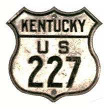
- US 227: commissioned as Kentucky intra-state route, not previously a US route.
- -3 +1, running total 67
- US 270[i]: redesignated as US 70-S (a split route of US 70).
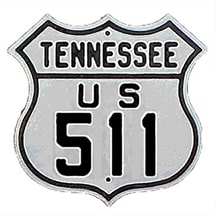
- US 511: redesignated as US 11-E (a split route of US 11).
- -2, running total 65
- US 123[i]: commissioned as Kentucky intra-state route, previously US 23.
- US 189[i]: commissioned as Utah intra-state route, not previously a US route.
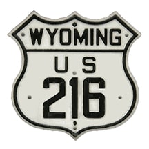
- US 216: commissioned as Wyoming intra-state route, not previously a US route.
- US 221: commissioned as North Carolina intra-state route, not previously a US route.
- US 377: commissioned as Texas intra-state route, not previously a US route.
- US 421: commissioned as North Carolina intra-state route, not previously a US route.
- +6, running total 71
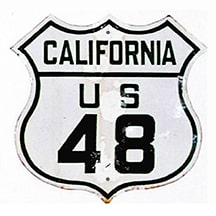
- US 48[i]: subsumed by extension of US 50.
- US 175: commissioned as Texas intra-state route, not previously a US route.
- US 280: commissioned as Georgia intra-state route, not previously a US route.
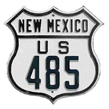
- US 485: subsumed by extension of US 64.
- -2 +2, running total 71
- US 32: truncated, became Illinois intra-state route.
- US 42: extended into Kentucky.
- US 76: extended into Tennessee.
- US 221: extended into Virginia and South Carolina.
- US 258: commissioned as North Carolina intra-state route, not previously a US route.
- US 260: commissioned as Arizona intra-state route, not previously a US route.
- US 264: commissioned as North Carolina intra-state route, not previously a US route.
- US 366[ii]: commissioned as New Mexico intra-state route, previously US 470.
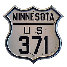
- US 371[i]: commissioned as Minnesota intra-state route, not previously a US route.
- US 401[i]: subsumed by new US 58 designation.
- US 411[i]: subsumed by extension of US 421.
- US 411[ii]: commissioned as North Carolina intra-state route, not previously a US route.
- US 421: extended into Virginia.
- US 470: replaced by US 366 designation.
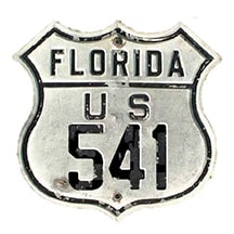
- US 541: commissioned as Florida intra-state route, not previously a US route.
- US 566: subsumed by new US 380 designation.
- US 601: extended into North Carolina.
- -9 +8, running total 70
- US 98: commissioned as Florida intra-state route, not previously a US route.
- US 178: commissioned as South Carolina intra-state route, not previously a US route.
- US 216: extended into South Dakota.
- US 319: commissioned as Florida intra-state route, not previously a US route.
- US 360: commissioned as Virginia intra-state route, not previously a US route.
- US 420: subsumed by extension of US 14.
- US 450: truncated, became Utah intra-state route.
- US 460: commissioned as Virginia intra-state route, most was not previously a US route.
- -2 +6, running total 74
- US 32: subsumed by extension of US 34.
- US 43: commissioned as Alabama intra-state route, not previously a US route.
- US 53: extended into Minnesota.
- US 68: extended into Ohio.
- US 104: commissioned as New York intra-state route, not previously a US route.
- US 116: subsumed by extension of US 14.
- US 117[ii]: truncated, became North Carolina intra-state route.
- US 123[i]: subsumed by extension of US 119.
- US 150: extended into Kentucky and Illinois.
- US 152: commissioned as Indiana intra-state route, not previously a US route.
- US 163[i]: commissioned as Iowa intra-state route, previously US 63.
- US 168: subsumed by extension of US 150.
- US 209: extended into New York.
- US 299: commissioned as California intra-state route, not previously a US route.
- US 311: truncated, became North Carolina intra-state route.
- US 395: extended into California.
- US 399: commissioned as California intra-state route, not previously a US route.
- US 411[ii]: subsumed by extension of US 220.
- US 430: became state route.
- US 550: extended into New Mexico.
- -12 +8, running total 70
- US 122[ii]: commissioned as Pennsylvania intra-state route, some was previously US 120.
- US 129: extended into Tennessee.
- US 159: commissioned as a Kansas intra-state route, previously part of US 73W.
- US 185: subsumed by extension of US 87.
- US 190: extended into Texas.
- US 231: extended into Florida.
- US 601: truncated, became North Carolina intra-state route.
- -4 +3, running total 69
- US 112: truncated, became Michigan intra-state route.
- US 260: extended into New Mexico.
- US 650: partly subsumed by new US 285 designation, remainder became state route.
- -2 +1, running total 68
|
To recap that first decade: the original system started out with 71 single-state US routes. By 1929 that number dropped to 65, but then climbed to a high of 74 routes in 1933, and by the end of 1936 the number had dropped to 68... a slight fluctuation, but overall not much of a change in the total count of intra-state routes. So clearly single-state routes were still regarded as an integral part of the US highway system. But in 1937, AASHO decided that mindset needed to change. That year they published a document titled "New Signing Policy on U.S. Routes". The whole article is an interesting read, but one particular excerpt is relevant to the topic of this page:
|
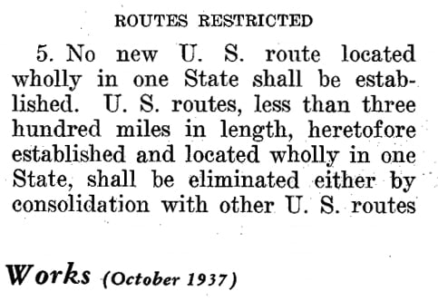
|
Starting in 1937, AASHO encouraged the states to eliminate their intra-state routes.
It is interesting to speculate on the reason(s) why AASHO decided to change its position on single-state US routes. During those early years many civic-minded people believed that one important key to economic prosperity was to have their town served by a US route (similar to the previous mindset about being located on a railroad, or the current mindset about the importance of being connected to the Interstate highway system). But when looking at some of the additions to the system listed above, it seems apparent that some of the new routes were only of regional importance, and did not quite belong with the most important highways in the national network.
|
|
At any rate, AASHO had clearly reached a point where they believed a change was necessary, and they began to emphasize the fact that state highways were perfectly capable of facilitating intra-state connections. This had an immediate impact: within just two or three years, the number of single-state US routes was quickly reduced by 17 (and after that the count continued to drop, although much more gradually). Following is a continuation of the timeline for the next three decades (from 1937 through 1969). By the end of this period, the overall number of intra-state routes had been reduced by half:
1937
- US 124: became state route.
- US 178: extended into North Carolina.
- US 319: extended into Georgia.
- -3, running total 65
- US 110: became state route.
- US 118: subsumed by extension of US 151.
- US 151: extended into Iowa.
- US 152: reverted to state route.
- US 161: subsumed by extensions of US 151 and US 218.
- US 163[i]: became state route.
- US 320: became state route (later part of extended US 26).
- -7, running total 58
- US 43: extended into Tennessee.
- US 96[i]: subsumed by extension of US 59.
- US 96[ii]: commissioned as Texas intra-state route, previously US 59.
- US 189[i]: became state route.
- US 366[ii]: partially subsumed by extension of US 66, remainder became state route.
- US 370: subsumed by extension of US 287.
- US 450: subsumed by extension of US 160.
- US 530: subsumed by extension of US 189.
- -7 +1, running total 52
- US 95: extended into California.
- US 158: truncated, became North Carolina intra-state route.
- US 258: extended into Virginia.
- -2 +1, running total 51
- US 330: redesignated as US 30-A.
- -1, running total 50
- US 159: extended into Missouri.
- -1, running total 49
- US 166: extended into Missouri.
- -1, running total 48
- US 460: extended into Missouri.
- -1, running total 47
- US 441: extended into Georgia.
- -1, running total 46
- US 94: subsumed by extension of US 41.
- -1, running total 45
- US 541: subsumed by relocation of US 41 (the old alignment of which was replaced by extension of US 301).
- US 601: extended into South Carolina.
- -2, running total 43
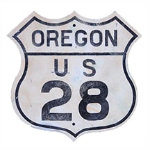
- US 28: partly subsumed by extension of US 26, remainder became US 126.
- US 126: commissioned as Oregon intra-state route, previously US 28.
- -1 +1, running total 43
- US 280: extended into Alabama.
- -1, running total 42
- US 46: truncated, became New Jersey intra-state route.
- +1, running total 43
- US 98: extended into Mississippi. (From 1952-1955, US 98 was the longest-ever single-state US route, at about 655 miles in length.)
- -1, running total 42
- US 156: commissioned as Kansas intra-state route, previously US 50-N.
- +1, running total 43
- US 312: commissioned as Montana intra-state route, previously US 12.
- +1, running total 44
- US 112: subsumed by reroute of US 12.
- -1, running total 43
- US 49: extended into Arkansas.
- US 122[ii]: became state routes.
- -2, running total 41
- US 299: became state route.
- US 399: became state route.
- -2, running total 39
- US 58: rerouted in Bristol, became Virginia intra-state route.
- US 230: became state route.
- -1 +1, running total 39
- US 120: became state route.
- -1, running total 38
- US 295: became state route.
- US 309: became state route.
- US 377: extended into Oklahoma.
- US 830: became state route.
- -4, running total 34
- US 99: truncated, became Oregon intra-state route.
- US 195: truncated, became Washington intra-state route.
- US 210: became state route.
- -1 +2, running total 35
Even after 1937, a few new intra-state routes were still created.
Despite AASHO's 1937 edict, a few additional intra-state US routes were still created during the 1940s through the '60s -- eight, to be exact. It should be noted that only four of them were newly-commissioned, whereas the other four simply became single-state routes due to truncations or reroutings (US 46, 58, 158, and 195). But still, why did AASHO allow the four new intra-state routes? Here is my take: the verbiage of the 1937 document specified "...no new US route..." (emphasis mine).
|
In all four of those instances, the new numbers were applied to routes that were not new to the system. Rather, those corridors had already been accepted into the US highway system; they simply needed new numbers because their former numbers had been rerouted or eliminated:
|
|
Exceptions notwithstanding, overall the number of intra-state US routes steadily declined after 1937, which suggests that for many years AASHO continued to push the states to eliminate them. In the minutes of their June 1970 meeting, they even included a list of single-state routes that were still in existence at the time:
|
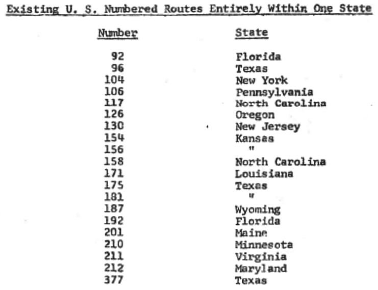
There are several things (both on that list and omitted from that list) that are worthy of comment. We will begin by noting a typo: there has never been a US 212 in Maryland. We can be quite certain they meant to type "213". Also, two of the routes on that list should not have been included. At their previous meeting (Oct. 1969) AASHO had just granted approval for Minnesota to decommission US 210. And one year before that (June 1968), they approved an extension of the US 377 designation into Oklahoma, so it was no longer a single-state route. So that leaves 18 routes, but it would be an error to assume that list was complete... because we should also note several routes that were overlooked. At the time, there were not 18, but actually 35 single-state US highways -- twice as many as were listed. 17 additional routes should have been included, as follows:
|
|
|
|
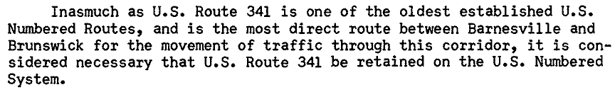
That oversight was probably embarrassing for AASHO, and the following year they issued a corrected list (as we will see below). However, there was also something utterly baffling: less than five months after AASHO issued their original 1970 list, they turned around and approved the creation of intra-state US 57 in Texas, along a route that was not previously included in the US highway system. I have outlined the reasons for that on the US 57 page, but whatever the rationale, I imagine AASHO lost a lot of credibility by approving US 57, and it would be understandable if that was the reason several state DOTs felt it was not worth the bother to take any further action in response to AASHO's latest request to eliminate intra-state US routes. Georgia was perhaps the first of the state DOTs to push back against AASHO's suggestions. The following excerpt from their Jan. 1971 letter to AASHO contained one good point and one dubious argument:
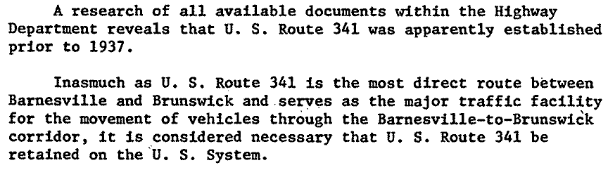
"1937" was a reference to the year AASHO first suggested that single-state US routes should be eliminated, and Georgia was highlighting the fact that US 341 was commissioned prior to that. But their suggestion that the Brunswick-Barnesville corridor was somehow deserving of special status was shaky at best.
AASHO's final attempt to eliminate intra-state routes was in 1971.
|
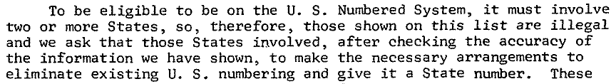
In July 1971 AASHO sent a revised list to the state DOTs. This one was greatly improved, as it contained 32 single-state routes. US 104 and US 126 were no longer included, because by then NY and OR had already changed them to state routes. There were only two intra-state routes notably absent from the 1971 list. One was US 74. And the other was US 57... which AASHO had just approved eight months earlier. That must have come across as quite disingenuous. And so must have AASHO's July 1971 letter, which emphasized their position even more forcefully, going so far as to call intra-state US routes "illegal":
|
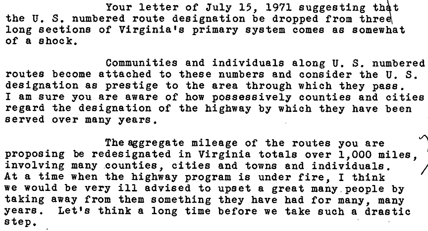
Some state DOTs responded with equal fervor against eliminating intra-state routes. In the following excerpt from Virginia DOT's letter, the "three long sections" refers to their three single-state routes (US 58, US 211, and US 360):
Georgia weighed in again, but did not make any additional points beyond what was said in their previous letter:
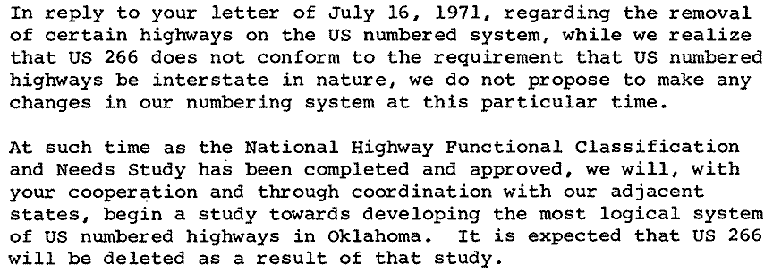
Oklahoma said they did not contemplate taking any immediate action on US 266, but at the same time they made an interesting comment that they "expected" to delete it at some time in the future:
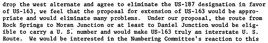
Utah was a little more diplomatic, noting that their joint proposal with Wyoming to extend US 163 northward (which AASHO had just recently disapproved) had the potential to not only eliminate intra-state US 187 but also to make the short US 163 a more legitimate US route:
Washington did not seem to have a strong opinion either way, but they simply noted the possibility that US 195 was about to lose its intra-state status:
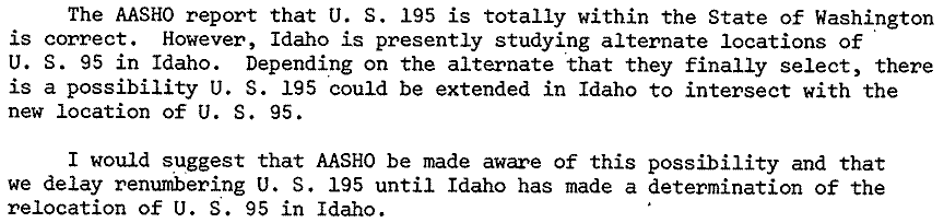
US 195 was indeed extended into Idaho a few years later. But, with the exception of US 187, all of the other US routes mentioned in those letters remain intra-state highways to this day. And with regard to the others, now that we have a complete list of the single-state US routes that existed at the time, we can determine that within three years, the overall count had been reduced by seven. And during the 1980s eight additional intra-state routes would be eliminated, but beyond that the effort completely stalled. Following are the remaining changes to single-state US routes, from 1970 to present:
1970
1970
- US 57: commissioned as a Texas intra-state route, not previously a US route. This was the last single-state US route to be commissioned.
- +1, running total 36
- US 99: became state route.
- US 104: became state route.
- US 126: became state route.
- US 371[i]: became state route.
- -4, running total 32
- US 227: became state route.
- US 611: became state route.
- -2, running total 30
- US 106: became state routes.
- US 213: partly subsumed by US 301, remainder became state route.
- -2, running total 28 (also note AASHO became AASHTO)
- US 154: became state route.
- US 156: became state route.
- -2, running total 26
- US 131: extended into Indiana.
- US 195: extended into Idaho.
- -2, running total 24
- US 58 extended into Tennessee.
- US 312: subsumed by extension of US 212.
- -2, running total 22
- US 187: subsumed by extension of US 191.
- -1, running total 21
- US 74: extended into Tennessee.
- -1, running total 20
- US 311: extended into Virginia.
- -1, running total 19
Currently the US route system still includes 19 intra-state routes.
Of those 19, 11 were among the inaugural routes of 1926 (shown in bold below). Here is the current list of single-state US routes (with some notes), sorted in order of approx. mileage:
- 266 (43.0 mi. in OK) See US 266 page.
- 211 (59.0 mi. in VA) Historically extended into DC.
- 350 (72.8 mi. in CO)
- 192 (74.6 mi. in FL) Can’t use the same excuse as US 92, because it doesn’t even make it all the way across the peninsula.
- 46 (74.9 mi. in NJ) Historically went a fraction of a mile into PA; see this blog post.
- 130 (83.2 mi. in NJ) Might make a good northern extension of US 301.
- 57 (98.4 mi. in TX) Connects to international port-of-entry and Mexico hwy. 57.
- 175 (109.9 mi. in TX) Could become an extension of US 75; current endpoints are separated by only two miles.
- 117 (113.5 mi. in NC)
- 181 (135.9 mi. in TX)
- 201 (157.3 mi. in ME) Connects to international port-of-entry and Quebec hwy. 173.
- 96 (165 mi. in TX) See this blog post.
- 171 (178 mi. in LA)
- 92 (182 mi. in FL) East-west route that spans the entire breadth of peninsula.
- 264 (213 mi. in NC)
- 341 (224 mi. in GA)
- 360 (225 mi. in VA) Should be extended along US 311 to Winston-Salem; see this blog post.
- 290 (274 mi. in TX)
- 158 (346 mi. in NC) Historically routed into VA. Over 300 miles long, so does not violate 1937 AASHO guidelines.
Which state currently has the most intra-state routes? And what about historically?
An examination of the list above reveals that five of the 19 current single-state routes are in Texas. As it turns out, Texas has had a minimum of four intra-states ever since the US route system was inaugurated in 1926. And during the 1930s it actually claimed six. Maybe that should not be surprising, given the size of Texas. However, six is not the most that any state has ever had.
Way up at the top of this page, the 1926 list shows that Pennsylvania had eight intra-states at the time... although that is a bit misleading, because by the time Pennsylvania actually began signposting their US routes in 1928, they were down to six. Still, there is no question that Pennsylvania was very fond of their intra-states for a long time: they held on to seven of them all the way until 1963, a span of 35 years. On the other hand, once they decided to start eliminating their intra-states, they were quick about it: within a decade, all but one were gone.
Way up at the top of this page, the 1926 list shows that Pennsylvania had eight intra-states at the time... although that is a bit misleading, because by the time Pennsylvania actually began signposting their US routes in 1928, they were down to six. Still, there is no question that Pennsylvania was very fond of their intra-states for a long time: they held on to seven of them all the way until 1963, a span of 35 years. On the other hand, once they decided to start eliminating their intra-states, they were quick about it: within a decade, all but one were gone.
|
For a three-year period during the mid-1930s, Florida also claimed seven signposted intra-states.
North Carolina had six intra-states from 1935-1949. And they had at least five from 1934-1982, a span of 48 years. Both Wisconsin and Wyoming started out with five each in 1926 (tied for second behind Pennsylvania). Wyoming even increased to six during the early 1930s. But after that both states began to eliminate them quickly: by 1938 Wyoming had only one intra-state remaining, and Wisconsin had none. |
Should the surviving intra-state routes be eliminated?
People who have put some thought into single-state US routes are generally divided on how they should be handled going forward. Some are of the opinion that they should be allowed to remain, for various reasons (e.g. they have been in the system since the beginning; important connecting routes should not be required to cross a state line; they don't do any harm so it's not worth the hassle and expense of changing them; etc.) Others insist that intra-state US routes are not appropriate, and that they should be replaced with state highway designations.
|
I can see both sides, but I also think the point is moot, because it appears AASHO/AASHTO has not made any effort to enforce their guideline since the 1970s. So I believe the 19 remaining single-state routes that survived the earlier purges are "safe" from that organization now. I seriously doubt AASHTO will ever issue another edict about this -- they have long since stopped concerning themselves with that kind of thing. Of course it is always possible that an individual state DOT may have a compelling reason to convert an intra-state US route to a state route, but keep in mind these routes have been around for decades. Any states that wanted to systematically decommission their intra-state US routes already did so a long time ago (the last state to do this was Kansas, back in 1979).
|
|
There are also several defacto intra-state routes.
For those who think the state DOTs should decommission their intra-states, I think it is only fair to also take a position on what I call "stealth violators". These are US routes that often escape scrutiny because they do enter a second state... but they do so only for a very short distance, so in a practical sense they are de facto single-state routes. What should be the minimum mileage in a second state for a highway to be considered a "legitimate" US route? The answer is open to debate, but the list below includes those with 15 miles or less. In my opinion, some of the following stealth violators are even worse than some of the actual violators listed above. These are sorted in order of total mileage in the second state:
- US 206: 129.8 mi. in NJ, 0.4 mi. in PA.
- US 195: 93.2 mi. in WA, 0.5 mi. in ID.
- US 166: 163 mi. in KS, 0.6 mi. in MO.
- US 58: 508 mi. in VA, 0.7 mi. in TN. (although this is well over the 300-mile threshold)
- US 223: 46.3 mi. in MI, 0.8 mi. in OH. (not just single-state; 90% of US 223 is in a single county, if one ignores the pointless overlap with US 23)
- US 131: 270 mi. in MI, 0.8 mi. in IN.
- US 197: 60.5 mi. in OR, 2.8 mi. in WA.
- US 177: 229.5 mi. in OK, 3.5 mi. in KS.
- US 222: 91.4 mi. in PA, 3.6 mi. in MD.
- US 521: 173.6 mi. in SC, 3.7 mi. in NC.
- US 730: 35.5 mi. in OR, 6 mi. in WA. (currently the shortest route in the entire US highway system)
- US 178: 234 mi. in SC, 6.5 mi. in NC.
- US 311: 57.9 mi. in NC, 7.5 mi. in VA. (see this blog post)
- US 138: 59.9 mi. in CO, 11.4 mi. in NE.
- US 48: 142.8 mi. in WV, 14.2 mi. in VA.
- US 400: 467 mi. in KS, 14.7 mi. in CO, 0.6 mi. in MO. (see this blog post)
US route shield images courtesy of Michael Summa. Research and/or photo credits: Nathan Edgars; Mike Roberson; Dale Sanderson
Page originally created 2020;
last updated Jul. 2, 2024.
last updated Jul. 2, 2024.
