End of US highway 98 |
 |
|
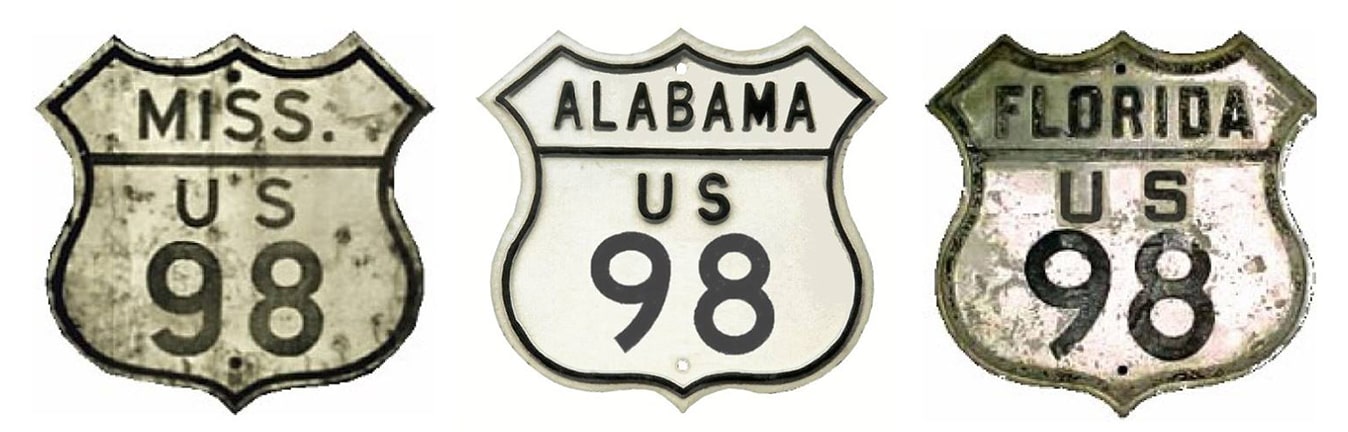
1933-1952
|
1952-1955
|
1955-present
|
*In 1999 Mississippi internally truncated US 98 to Bude, reducing its total length to 928.0 miles. However, US 98 was still signposted to Washington until 2008, and then in 2010 new signage in Natchez included references to US 98. So as of 2020 US 98's signposted length was 962.5 miles (more below). US 98's maximum historical extent was 965.3 miles (to the Louisiana state line). Also note: although US 98 is signed east-west at both of its endpoints, it is signed north-south along a 300-some-mile segment through peninsular Florida (between Perry and the Okeechobee-Martin county line, which is roughly between the city of Okeechobee and Port Mayaca). That is about half of US 98's Florida mileage, and about one-third of its overall mileage.
Summa
|
Claim to fame: during the three-year period when US 98 ran between Pensacola and Palm Beach, it was the longest-ever intra-state US route (about 655 miles).
|
|
US 98 was commissioned in 1933; at the time it was an intra-state route, with its east end in Apalachicola, and its west end in Pensacola. In 1955 US 98 was extended west to Natchez. In late 1951 AASHO approved FDoT's request to extend US 98 to its present terminus in West Palm Beach...
|
|
|
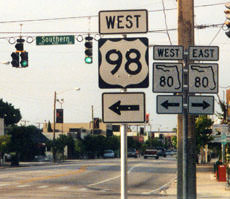
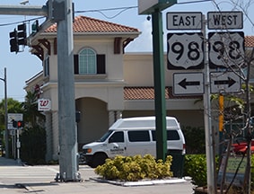
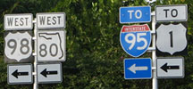
...although because of ambiguous signage in the area, one could easily conclude that the terminus is actually in Palm Beach (as we will see below). This first photo was taken in West Palm Beach, looking north on Dixie Highway (US 1) at Southern Boulevard:
|
Sanderson, Oct. 2003
|
|
Back then it seemed that FL hwy. 80 went both ways, but that US 98 began to the left. However, as of 2016 no reference to US 98 exists there.
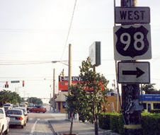
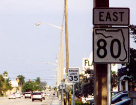
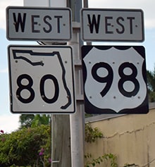
Posted information has also changed for drivers heading the opposite direction: |
Sanderson, Oct. 2003
|
Nasiatka/Nitzman, July 2016
|
|
Formerly there was an old Florida-style colored shield indicating that US 98 began to the west. That has since been replaced, and more recently the designation was shown to extend east as well. (Note also that Dixie runs both ways. Some maps indicate it is one-way southbound, while the next block to the east [Olive Avenue] is the northbound counterpart. It may well have been that way in the past, but now Olive has its own designation: FL hwy. 5.)
Anyway, perhaps US 98 does end here at US 1 -- if so, then maybe there is an "End" sign on eastbound Southern... |

Sanderson, Oct. 2003
|
|
...nope. But neither did that assembly indicate that US 98 continues ahead. So what does the confirming assembly past US 1 say?
|
Sanderson, Oct. 2003
|
|
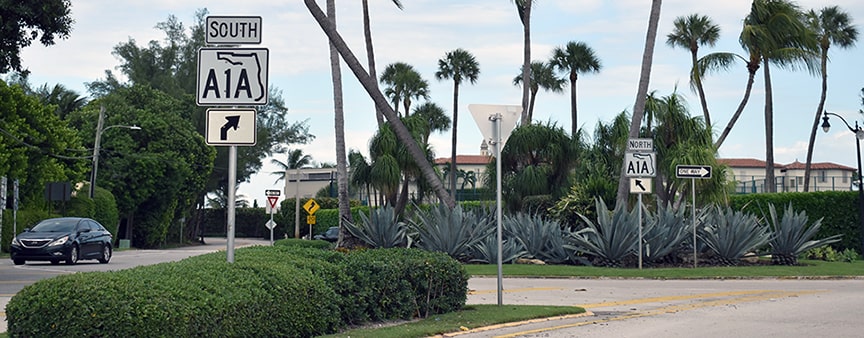
Hmm, no more US 98. Continuing eastbound, there is a bridge over the Intracoastal Waterway, and in about one mile is a junction with FL hwy. A1A in Palm Beach (I did not observe any US 98 markers on that stretch). At FL A1A there is a rotary:
|
Nitzman, Oct. 2021
|
|
Southbound A1A simply makes a right turn, while northbound traffic goes halfway around the circle and then continues east for a block or so (on the same alignment as Southern) before curving to the north. Despite the signage back at US 1, there is a lot of evidence to suggest that rotary is the true east end of US 98. For example, check out the signage heading north on FL A1A...
Field/Nitzman, Feb. 2008
|
Formerly there was also a "JCT US 98" sign heading south on A1A (but it was gone as of 2008). There were also "JCT US 98" signs on both nb and sb Olive. So, despite the misleading signage at US 1, it seems pretty clear that the US 98 designation still extends a bit east of US 1, and ends at its junction with A1A. The historic terminus was certainly at A1A; reportedly it was about the mid-1990s that FDoT started messing with things.
|
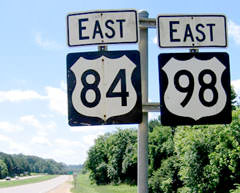
In about 1999 it seems Mississippi unilaterally decided to truncate the west end of US 98 to its junction with US 84 at Bude. This would allow them to discontinue unnecessarily triple-signing a six-mile segment as US 61-84-98, and also to avoid dual-signing a 29-mile segment as US 84-98. However, now that more than two decades have passed, I have to conclude MDoT either botched or aborted their attempt. Why? Well, for one thing, they never obtained AASHTO's approval to truncate US 98. And secondly, as of 2022 half of the sign assemblies between Bude and Natchez still refer to US 98.
|
It seems MDoT attempted to do the sign removal in phases: initially westbound US 98 was still signed through Bude, but ended at its junction with US 61 in Washington (a few miles northeast of Natchez). Here is the former signed end of US 98, along with enlargements of the two assemblies visible in the distance:

Cozart/Nitzman, June 2004
|
Cozart/Nitzman, June 2004
|

Cozart/Nitzman, June 2004
|
|
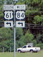
Signage for US 98 disappeared at that junction, and to the left (southwest) were trailblazers only for US 61-84 (signs with references to US 98 were either removed or greened out).
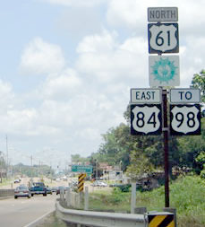
Coming the opposite direction (east from Natchez) on US 84 (which is also northbound US 61), the road was signed in many places as "TO US 98": |
Cozart/Nitzman, June 2004
|
|
A few miles further ahead was the turn to the signed west beginning of US 98:
|

Cozart/Nitzman, June 2004
|
|
This photo shows what was the signed beginning of US 98 as seen from the opposite direction (southbound US 61):
|

Cozart/Nitzman, June 2004
|
|
If a traveler took that left turn, they would soon see the first eastbound confirming marker...
|
Cozart/Nitzman, June 2004
|
|
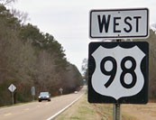
...but as of 2008, those two routes were no longer co-signed (or, more accurately, any US 98 signs along that segment were changed to read "TO US 98" as well). 29 miles ahead, at the exit from modern US 84 to Bude, the first eastbound mention of standalone US 98 was posted:
|
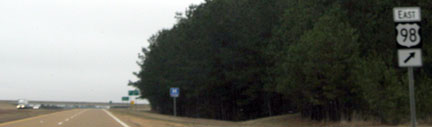
Ivy/Nitzman, Jan. 2009
|
|
The exit ahead leads to old US 84, which also serves as a short segment of US 98. This shot shows signage heading the opposite direction (west on US 84), after taking the offramp to the beginning of US 98:
|
Ivy/Nitzman, Jan. 2009
|
|
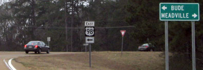
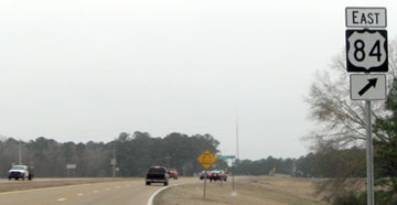
If a traveler turned left there, they would soon encounter the first eastbound marker:
|
Karners, Jan. 2010
|
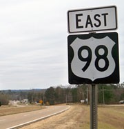
Heading the opposite direction (west on US 98), the last westbound marker is shown here:
|
Karners, Jan. 2010
|
|
About two miles ahead, there was no sign marking the endpoint, other than the standard junction signage at the US 84 interchange:
|
Ivy/Nitzman, Jan. 2009
|
In 2009, the intersection marking US 98's disputed western terminus in Natchez was rebuilt as a continuous-flow interchange. As a part of that project, all signage in the area was replaced... and strangely, almost all of the new signs included references to US 98! We contacted MDoT to ask about this, and were told that they still officially consider the route to end in Bude. And the highway statistics document that MDoT posts online is still clear about that as recently as 2021:
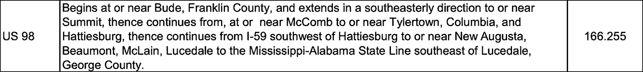
So then why is US 98 still signed in Natchez? We were told that the erroneous US 98 shields in Natchez may have resulted from the signage contractor referring to AASHTO's information (which has not been updated in years, and which still says the route ends in Natchez), rather than referring to MDoT's own statistics. They said a fix was planned for the future, but fifteen years later there are still many US 98 signs in Natchez. Specifically, out of the six sign installations around the disputed terminus in Natchez, all but one of them include a reference to US 98. So it would be really difficult to convince the driving public that US 98 no longer exists in Natchez.
Outside of Natchez, all but one of the signs that formerly said "TO US 98" have been changed to just US 98 (with no modifier). Furthermore, at the interchange with US 84 in Bude, newer signage directs US 98 traffic further west with US 84, towards Natchez. Granted, those are the last references to US 98 for westbound traffic, but they certainly do not indicate that US 98 terminates in Bude. MDoT would have to make many changes to field signage in order to reflect the notion that US 98 terminates in Bude... and unless that happens we have to say that US 98 still ends in Natchez.
Outside of Natchez, all but one of the signs that formerly said "TO US 98" have been changed to just US 98 (with no modifier). Furthermore, at the interchange with US 84 in Bude, newer signage directs US 98 traffic further west with US 84, towards Natchez. Granted, those are the last references to US 98 for westbound traffic, but they certainly do not indicate that US 98 terminates in Bude. MDoT would have to make many changes to field signage in order to reflect the notion that US 98 terminates in Bude... and unless that happens we have to say that US 98 still ends in Natchez.
Research and/or photo credits: Justin Cozart; Chuck Dent; Andy Field; Brent Ivy; Karin and Martin Karner; J.P. Nasiatka; Alex Nitzman; Jim Pernikoff; Dale Sanderson; Michael Summa
Page originally created 2002;
last updated Dec. 19, 2023.
last updated Dec. 19, 2023.
