End of US highway 35 |
 |
|
1934-1969
|
1969-2008
|
2008-present
|
Summa
|
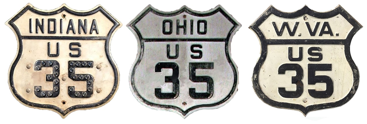
Mileage: in 1989 AASHTO listed a figure of 424 miles for US 35... but at the time, US 35 ended in St. Albans. Since then it has been truncated to Scott Depot, and our own 2020 measurement yielded 416.3 miles. At its maximum historic extent (Charleston to downtown Michigan City) US 35 was 440.6 miles long. Note: US 35 is signed north-south in Indiana and West Virginia, but all through Ohio it is signed east-west.
|
|
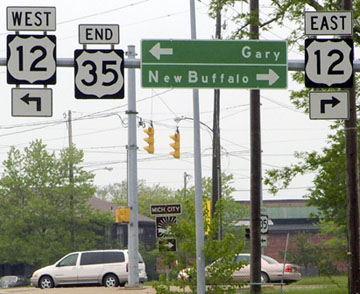
For the majority of the time since it was commissioned in 1934, the north end of US 35 was at its junction with US 12. This photo was looking westbound on that route:
|
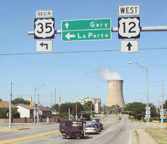
Hargraves, 2002
|
|
Historically westbound US 12 came in from the right, and then continued straight ahead, but even then US 35 began to the left on Michigan Boulevard. Note the "Begin" sign: very unusual, especially used in that situation (and that reference to US 35 was removed in 2009). Same thing from the opposite direction (eastbound US 12), shown here:
|
Hargraves, 2002
|
Hargraves, 2002
|
|
Normally one would expect to see a "South" banner instead of "Begin" there. That US 35 assembly was also removed in 2009, but after a few years it was replaced with something almost identical, except it says "TO US 35".
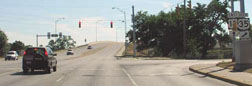
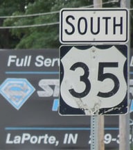
Prior to 2009, if a driver took that right turn, they would promptly see the first southbound confirming marker: |

Sanderson, May 2005
|
|
At their Nov. 1975 meeting, AASHTO approved INDoT's request to truncate US 35 to its junction with US 20...
|
|
|
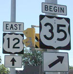
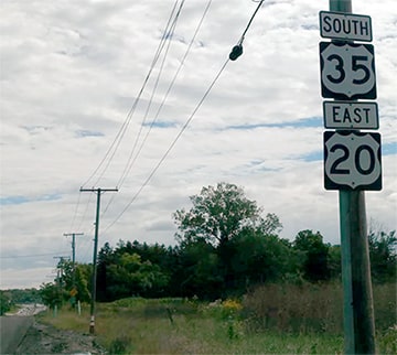
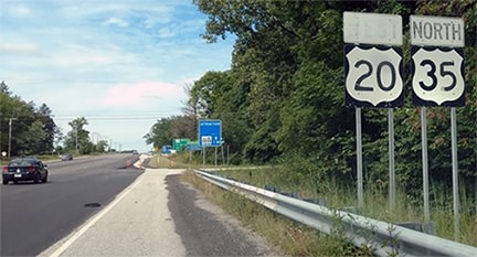
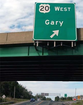
...and some people have written with their recollection that, sometime during the 1980s, US 35 was signed as if it began about four miles ahead, just past I-94's interchange 40, at the junction with US 20. Backing that up is the 1989 AASHTO route log, which lists US 20 (not US 12) as the beginning of US 35. However, INDoT official maps all through the 1980s continued to show US 35 ending at US 12, and that is how it was signed as of the early 2000s. Regardless, in October 2008, INDoT again obtained AASHTO approval to truncate the US 35 designation to that junction (that is, its east junction with US 20). However, in 2009 INDoT removed US 35 references only as far as the west junction; until 2019 US 35 was signed as if it still existed along the 1.3 mile overlap with US 20. We will proceed southeast on Michigan Blvd to view each of these endpoints. From 2009-2019, just beyond the interchange with US 20/IN 212 was the first southbound US 35 marker:
|
Handler, Sep. 2018
|
|
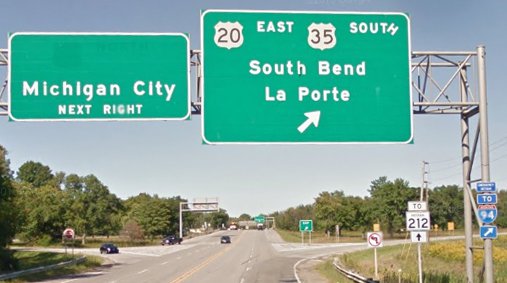
The I-94 interchange is visible in the distance. Just beyond there is this sign bridge:
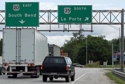
Sanderson, Sep. 2014 (unchanged as of 2019)
|
At the time of that photo, US 35 signage extended about a mile behind the camera, but as of 2019 that marks the north beginning of US 35, and it was not necessary to make any changes to that sign. At the gore point in the background was another assembly, shown close-up here:
Sanderson, Sep. 2014 (unchanged as of 2019)
|
|
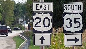
After taking that turn to the right, one immediately encounters the first southbound trailblazer:
Sanderson, Sep. 2014
|
|
|
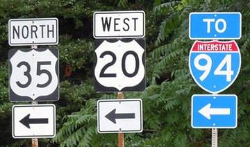
Now heading that direction, from 2009-2019 the last northbound US 35 marker was posted between I-94 and the US 20/IN 212 interchange:
Handler, Sep. 2018
|
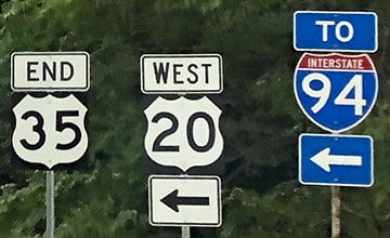
There was no "End" assembly at that interchange, but neither were there any more references to US 35, so this marked the north terminus for about ten years:
Handler, Sep. 2018
|
|
This image was taken at the same interchange, but heading eastbound on US 20, which continues to the right. That movement was signed as if it also marked the north beginning of US 35 (even though INDoT's application specified that it would not begin until the junction where it splits from US 20, about a mile to the right. In 2018 the district DOT informed us that, when they next replaced signage, they intended to remove US 35 references along that overlap, and that happened in 2019). Until 2009, US 35 continued further northwest (left), and upon close inspection, the ghost where "US 35 NORTH" verbiage formerly appeared at the top of the Michigan City panel was still visible (but that panel was replaced sometime before 2018):
|
Google Maps Street View, Sep. 2013
|
|
Continuing northwest on Michigan Blvd, we return to US 35's historic terminus:
|
Sanderson, May 2005
|
To the right on 2nd is a newer bridge -- before that was built in about 1990, eastbound US 12 went straight ahead on Spring Street (for one block, before turning right to use the old 2nd Street bridge), but US 35 still ended at that same intersection.
|
|
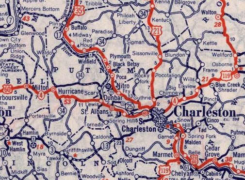
Historically, US 35 followed today's OH hwy. 588 straight into Gallipolis; then north along the Ohio River to Kanauga, where it crossed into Point Pleasant WV (this was via the no-longer-extant Silver Bridge, which collapsed in 1967, killing 46 people). Thus US 35 came into West Virginia on the north/east bank of the Kanawha River, and it stayed on that side (via what is now WV 62) all the way into Charleston:
|
c. 1939, Rand McNally
|
|
There was a rail spur where 7th Street is now; US 35 came in on Washington Street. At the time of this basemap (1935), US 35 stayed on Washington, as evidenced by the black casing showing that it followed Washington's jog to the north where it crosses Two Mile Creek (the original bridge is still there, just upstream from Washington's modern bridge). It is possible that US 35 terminated immediately after crossing the creek, where it met US 21 (Sissonville Drive), or it could have overlapped with US 21 for a few blocks, terminating at the junction with US 60 (Patrick Street). This map also shows a 1949 revision: what is now the 7th Street bridge is shown as a red road with no casing. That was built in 1943; at that time US 35 began using that bridge, and then turned north on Rebecca Street to Washington, where it met US 21. Again, US 35 could have ended there, or it could have been co-signed east one block to US 60:
|
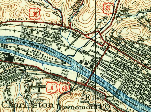
c. 1935 (with 1949 revisions), USGS
|
|
It is unfortunate that no highway signs are visible in this 1940s photo, but it is nevertheless a good image of a historic highway junction in Charleston. This was taken looking west on Washington, which veered to the left, while Sissonville was the curve to the right:
|
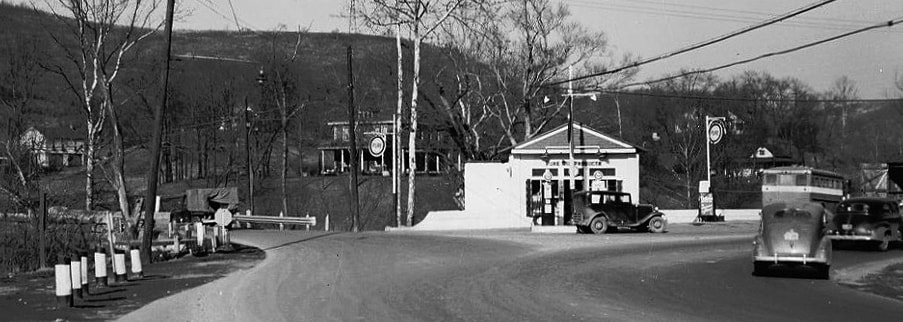
Photo courtesy of My West Virginia Home (linked to source)
|
|
That was the perspective of a driver on northbound US 21, which followed Sissonville to the right. Until the 7th St. bridge opened, northbound US 35 either continued -- or began -- to the left on Washington, depending whether it overlapped US 21 to its junction with US 60. This 1950s photo was taken looking north on Patrick, approaching Washington:
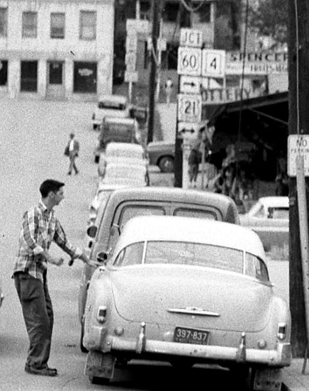
Photo courtesy of My West Virginia Home (linked to source)
|
That suggests US 35 may not have actually connected with US 60, although it is possible that traffic heading that direction may have been instructed to turn left on 7th in order to reach US 35. This more recent photo was taken from roughly the same perspective (north on Patrick/east on US 60):
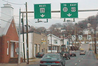
De Cesari/Moraseski
At the T-intersection in the distance, up the hill, US 60 turns right on Washington, which historically was also southbound US 21. Northbound US 21 was to the left, and that may have been the south beginning of US 35 as well, at least for traffic on westbound Washington. For traffic on northbound Patrick, US 35 may have turned to the left on 7th, just as WV hwy. 25 traffic is directed to do today.
During this timeframe, the road along the south bank of the Kanawha was designated WV 17, but today US 35 is on a limited-access freeway in the Point Pleasant area, which crosses the Ohio River roughly between there and Gallipolis. In June 1969, when that bridge was open (or about to open), AASHO approved West Virginia's request to reroute US 35 such that it stays on the south/west bank of the "kuh-NAW" (as locals pronounce the river), and partly for that reason it is no longer signed all the way into Charleston. |
|
Initially US 35 was truncated to its junction with US 60 in "Amandaville", which is not marked on most maps. This is an unincorporated community on the opposite side of the Coal River from St. Albans, about ten miles shy of Charleston:
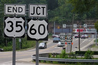
Morrison, Aug. 2005
|
This next photo shows what was the south beginning of US 35 as seen from eastbound US 60...
Morrison, Aug. 2005
|
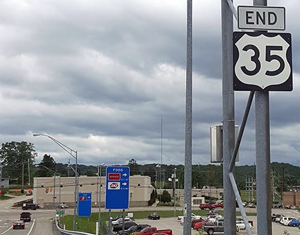
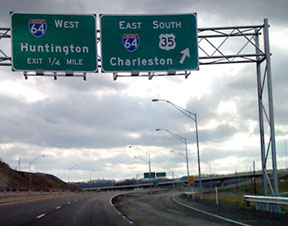
Interchange 44 is about three miles ahead. However, in October 2008 West Virginia sought and obtained approval from AASHTO to reroute the southernmost segment of US 35, so the highway has now been truncated even further out of Charleston, and it no longer passes through exit 44. US 35 now connects with I-64 at the new interchange 40. Approaching that junction is the first of two "End" signs:
|
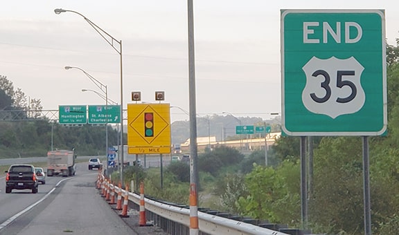
Head, Aug. 2019
|
|
US 35 is signed as if it actually continues almost another mile past that sign, terminating a bit beyond I-64 at its junction with Teays Valley Road. These shots show signage at that intersection:
|
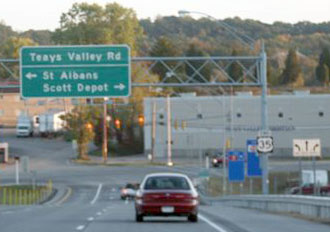
Elkins, Oct. 2008
|
Head, June 2017
|
|
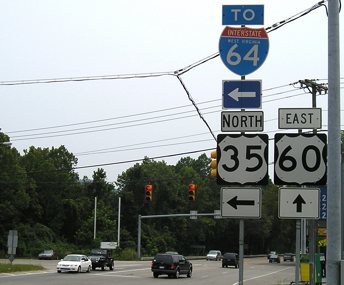
I believe officially US 35 ends at I-64 (just behind the camera), and this segment is actually "Spur US 35", which ends at the signal ahead. But this segment is signposted as if it is a part of mainline US 35. Heading east on Teays Valley Rd, the south beginning of US 35 is signed thus...
|
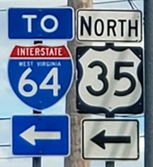
Head, Aug. 2019
|
...and if one takes that left turn, the first northbound marker looks like this:
|
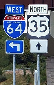
Head, Aug. 2019
|
|
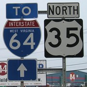
It is interesting to note that this new segment of US 35 was in use by locals for about a year before it "officially" opened, and signage had already been installed before AASHTO's approval to truncate the US 35 designation. Originally, signage reflected WVDoT's intent to overlap US 35 with I-64 to exit 44, and then resume its old routing to Amandaville:
|
Allevato, Dec. 2007
|
That was looking south on the new segment of US 35 -- traffic was initially directed to continue by using the flyover ramp to eastbound I-64. But now that US 35 has been truncated, it is signed as if it continues straight ahead through interchange 40, ending just beyond there.
Research and/or photo credits: Tony Allevato; Robert Brooks; Shawn De Cesari; Paul Dienhart; Nathan Edgars; H.B. Elkins; Marc Fannin; Mark Handler; Don Hargraves; Mike Head; Dan Moraseski; Jeff Morrison; Dale Sanderson; Jay Seaburg; Amy Stanley (INDOT); Michael Summa
Page originally created 2000;
last updated Dec. 16, 2023.
last updated Dec. 16, 2023.
