End of historic US highway 210
 |
|
|
|
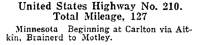
The function of US 210 was to connect US 10 to US 61 in Minnesota -- or, in other words, to provide a connection between Duluth and Fargo:
|
c. 1927, Rand McNally
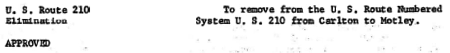
Presumably the reason it was finally changed to a state route is because short intra-state US routes had fallen into disfavor (AASHO had actually been calling for the deletion of intra-state US routes since 1937). Below is the relevant agenda item from AASHO's Oct. 1969 meeting:
|
The highway is now signed as MN hwy. 210, and that designation continues both farther east and west of the endpoints of historic US 210. This photo was taken in Motley, looking west on MN 210:
|
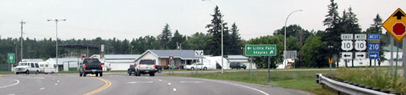
Otterson, June 2005
|
|
Just ahead is the junction with US 10, and the historic endpoint of US 210 (although it is clear that the 210 designation continues further west today). Here, we are looking east on US 10/MN 210:
|
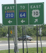
Otterson, June 2005
|
|
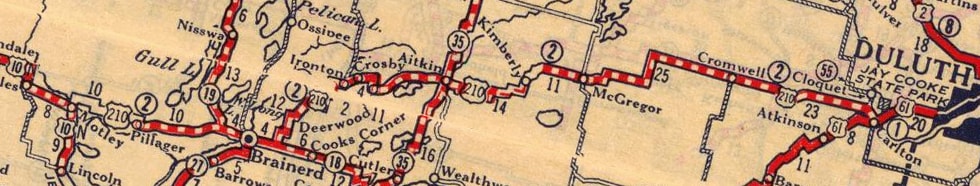
The two routes split there: US 10 curves to the south through Motley towards Little Falls, while MN 210 turns north, crosses the Crow Wing River, junctions with MN 64, and then resumes eastward towards Brainerd and Duluth. But until 1970, that left turn marked the west beginning of US 210. This map was made back when that was the case:
|
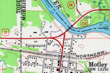
c. 1963, USGS
|
|
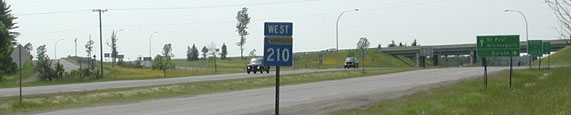
About 125 miles to the east, MN 210 crosses under I-35 at interchange 235, and then almost immediately comes to the junction shown here:
|

Otterson, June 2005
|
|
Historically, northbound US 61 came in from the right, and then continued straight ahead into Carlton. So US 210 could have ended at that junction, where its successor (MN 210) meets historic US 61 (now County Highway 61). However, there is some evidence that US 210 did not actually end there, but rather overlapped with US 61 ahead, ending right in town:
|
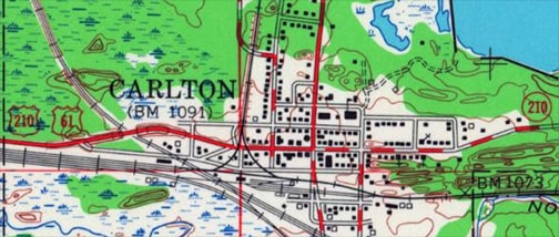
c. 1954, USGS
|
|
If so, then US 210 probably ended where US 61 made its turn northward. This interactive image is looking east on Chestnut Avenue. Historically this was northbound US 61 (which continued by turning left on 3rd Street) and eastbound US 210 (which ended here):
|
|
Heading the opposite direction (west), Chestnut's railroad crossing was not built until 1930. Prior to that, apparently Walnut Avenue was the main road heading west. Also, during those early years, apparently US 210 ran about a mile north of the current MN 210 corridor, coming into Carlton from the north. So the original endpoint of US 210 may have been on 2nd Street at Walnut until about 1930, and after that on Chestnut at 3rd.
|
|
Continuing west on Chestnut, one soon comes to the same intersection shown in the first Carlton photo on this page:
|
Otterson, June 2005
|
Whereas that intersection is the modern equivalent of the historic junction, CSAH 61 (visible at far left) had to be moved a ways to the east when I-35 was built through there, in order to make room for the offramps. Today northbound traffic comes towards the camera, curves off the left edge of the photo, and joins MN 210 behind the camera. But that is all a new alignment. Originally, US 61 came down the hill right about where the northbound offramp is now, and then came towards the camera via today's MN 210. So the junction where US 61 and US 210 separated is right about where the overpass is today.
Research and/or photo credits: Monte Castleman; Bob Otterson; Dale Sanderson; Michael Summa
Page originally created 2005;
last updated Dec. 10, 2023.
last updated Dec. 10, 2023.
