Historic US highway endpoints in Rapid City, SD
1928-1934
 |
|
|
In 1926, when the US route system was first implemented, US 16 did not run through the Black Hills west of Rapid City, as it does now. Instead, traffic was directed around the north edge of the Hills (essentially along what is now I-90, through Sturgis and Spearfish). And at the time, US 14 did not make it to the Black Hills at all; rather, its west terminus was at its junction with US 16 near Philip, far to the east of Rapid City. But that did not last long: already by about 1928 the US 14 designation had been extended west, concurrent with US 16 until reaching its new terminus in Rapid City. That was shown on the 1930 SDDoT map, but this commercial map from the same year illustrated that arrangement a little more clearly:
|
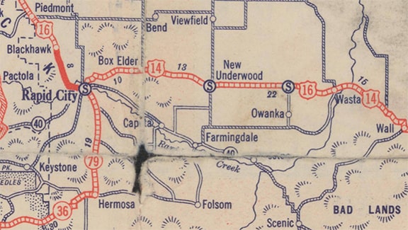
c. 1930, Gousha
|
|
Right about that time, US 216 was commissioned. Originally it was only in Wyoming, connecting US 16 at Moorcroft and US 85 at Newcastle. But in 1933, the US 216 designation was extended eastward into South Dakota, following what is now US 16 to Custer; US 16A and SD 36 to Hermosa; and SD 79 to Rapid City. The entirety of US 216 at its maximum extent was illustrated on this map:
|
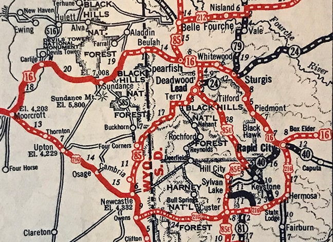
c. 1934, Gallup
|
We are fortunate to have a map which shows that arrangement, because it lasted only a year or two. In 1935 the US routes in this area were changed to more closely resemble today's arrangement. US 14 was extended northwest from Rapid City along the former US 16, skirting the north edge of the Black Hills. US 16 was changed to head southwest from Rapid City through the middle of the Black Hills, subsuming the former US 216 (with the exception of the segment through Hermosa, which retained its state route designations 36 and 79).
That was also the same timeframe when the first presidential carving on Mt. Rushmore was completed; certainly that new National Memorial was at least part of the motivation to have a US route serving that part of the Black Hills. But US 16 could have simply been left as it was, and instead the US 14 designation could have been extended past Mt. Rushmore and into Wyoming. Perhaps the reason US 16 was reassigned to the more southerly route was because east-west routes with higher numbers were generally expected to run south of those with lower numbers.
That was also the same timeframe when the first presidential carving on Mt. Rushmore was completed; certainly that new National Memorial was at least part of the motivation to have a US route serving that part of the Black Hills. But US 16 could have simply been left as it was, and instead the US 14 designation could have been extended past Mt. Rushmore and into Wyoming. Perhaps the reason US 16 was reassigned to the more southerly route was because east-west routes with higher numbers were generally expected to run south of those with lower numbers.
|
All of that aside, the main purpose of this page is to identify the location(s) in Rapid City that briefly served as the terminus point(s) for US 14 and US 216. Unfortunately I have not seen any map or photo or document that answers that question. If you have evidence of historic highway routings in Rapid City, please contact US Ends .com. I would not be surprised to find that both routes ended on St. Joseph Street at 8th Street. That is completely speculative, but here is a modern photo of that intersection, just in case:
|
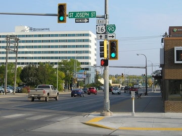
Morrison, Oct. 2020
|
|
When I last visited the area, I photographed the intersection of Main Street and East Boulevard, because at the time I thought that might have been the location of the endpoint. I no longer believe that was the case, but until I learn the truth, I will leave these old photos up just for the sake of making your visit to this page a little more rewarding. This photo was looking west on Main, which at the time was also northbound US 79:
|
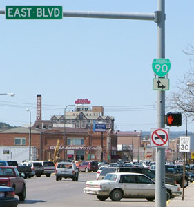
Sanderson, Mar. 2004
|
|
This was taken heading north on East Blvd:
Sanderson, Mar. 2004
|
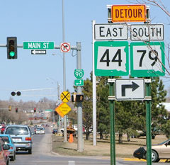
Since there is no signage looking east on Main, this photo shows the modern equivalent:

Sanderson, Mar. 2004
|
The detour signs posted there make this even more confusing to explain. Normally southbound SD 79 was straight ahead. That was looking east on St. Joseph Street, which is Main's eastbound counterpart.
|
Research and/or photo credits: Jeff Morrison; Dale Sanderson
Page originally created 1999;
last updated Dec. 3, 2023.
last updated Dec. 3, 2023.
