US Ends .com
  • Home
  • Store
    • US highway map
    • Florida US highway map
  • Endpoints
    • US 1 - US 9 >
      • 1 >
        • 201
        • 301
        • 401 [i]
        • 401 [ii]
        • 401
        • 501
        • 601
        • 701
      • 2w >
        • 102
      • 2e >
        • 202
        • 302
      • 3
      • 4 >
        • 104
      • 5
      • 6 >
        • 106
        • 206
      • 7
      • 8
      • 9 >
        • 109*
        • 209
        • 309
    • US 10 - US 19 >
      • 10 >
        • 110
        • 210
        • 310
        • 410
      • 11 >
        • 111
        • 211
        • 311
        • 411 [i]
        • 411 [ii]
        • 411
        • 511*
        • 611
        • 711*
      • 12 >
        • 112
        • 212
        • 312
      • 13 >
        • 113
        • 213
      • 14
      • 15
      • 16 >
        • 116
        • 216
      • 17 >
        • 17-1
        • 117 [i]
        • 117
        • 217
      • 18 >
        • 118
        • 218
      • 19 >
        • 119
        • 219
        • 319
    • US 20 - US 29 >
      • 20 >
        • 120
        • 220
        • 320
        • 420
      • 21 >
        • 121 [i]
        • 121
        • 221
        • 321
        • 421
        • 521
      • 22 >
        • 122 [i]
        • 122 [ii]
        • 222
        • 322
        • 422e
        • 422w
        • 522
        • 622*
      • 23 >
        • 123 [i]
        • 123
        • 223
      • 24 >
        • 124
        • 224
      • 25
      • 26 >
        • 126
      • 27 >
        • 127
        • 227
      • 28
      • 29 >
        • 129
    • US 30 - US 39 >
      • 30 >
        • 130
        • 230
        • 330
        • 430
        • 530
        • 630*
        • 730
        • 830
      • 31 >
        • 131
        • 231
        • 331 [i]
        • 331
        • 431
      • 32
      • 33
      • 34
      • 35
      • 36 >
        • 136
      • 38 >
        • 138
    • US 40 - US 49 >
      • 40 >
        • 140
        • 240
        • 340
      • 41 >
        • 141
        • 241 [i]
        • 241 [ii]
        • 341
        • 441
        • 541
        • 641
      • 42
      • 43
      • 44
      • 45
      • 46
      • 48 [i]
      • 48 [ii]
      • 48
      • 49
    • US 50 - US 59 >
      • 50 >
        • 150
        • 250
        • 350
        • 450
        • 550
        • 650
      • 51 - 55 >
        • 51 >
          • 151
        • 52 >
          • 152
        • 53
        • 54 >
          • 154
        • 55
      • 56 >
        • 156
      • 57
      • 58 >
        • 158
        • 258
      • 59 >
        • 159
        • 259
    • US 60 - US 69 >
      • 60 >
        • 160
        • 260
        • 360
        • 460
      • 61 - 65 >
        • 61 >
          • 161
        • 62
        • 63 >
          • 163 [i]
        • 64 >
          • 164 [i]
          • 164 [ii]
          • 264
        • 65 >
          • 165
      • 66 >
        • 166
        • 266
        • 366 [i]
        • 366 [ii]
        • 466
        • 566
        • 666
      • 67 >
        • 167
      • 68 >
        • 168
      • 69 >
        • 169
    • US 70 - US 79 >
      • 70 >
        • 170
        • 270 [i]*
        • 270
        • 370
        • 470
      • 71 >
        • 171
        • 271
        • 371 [i]
        • 371
      • 72 - 76 >
        • 72
        • 73
        • 74
        • 75 >
          • 175
          • 275
        • 76 >
          • 176
          • 276
      • 77 >
        • 177
        • 277
        • 377
      • 78 >
        • 178
        • 278
        • 378
      • 79
    • US 80 - US 89 >
      • 80 - 84 >
        • 80 >
          • 180 [i]
          • 180
          • 280
          • 380
        • 81 >
          • 181
          • 281
        • 82
        • 83 >
          • 183
          • 283
          • 383
        • 84
      • 85 - 89 >
        • 85 >
          • 185
          • 285 [i]
          • 285
          • 385 [i]
          • 385
          • 485
        • 87 >
          • 187
          • 287
        • 89 >
          • 189 [i]
          • 189
    • US 90 - US 99 >
      • 90 - 94 >
        • 90 >
          • 190
          • 290
        • 91 >
          • 191
          • 491
        • 92 >
          • 192
        • 93
        • 94
      • 95 -98 >
        • 95 >
          • 195
          • 295
          • 395
        • 96 [i]
        • 96
        • 97 >
          • 197
        • 98
      • 99 >
        • 199
        • 299
        • 399
    • Anomalies >
      • 101
      • 163
      • 400
      • 412
      • 425
  • Places
    • A-L >
      • A >
        • Aberdeen
        • Albuquerque
        • Amarillo
        • Apalachicola
        • Astoria
        • Atlantic
      • B >
        • Baltimore
        • Baton Rouge
        • Bay Area
        • Bishop
        • Boone
        • Bristol
        • Brownsville
        • Brunswick
      • C >
        • Charleston
        • Chattanooga
        • Chicago
        • Cincinnati
        • Cleveland
        • Cody
        • Corpus
        • Cortez
        • Council Bluffs
        • Covington
        • Crescent
        • Cumberland Gap
      • D-E >
        • Dallas
        • Des Moines
        • Detroit
        • Dothan
        • Douglas
        • El Paso
        • Eugene
        • Erie
      • F >
        • Farmington
        • Flagstaff
        • Florence
        • Fox Valley
        • Franklin
      • G >
        • Gallup
        • Grand Junction
        • Grand Portage
        • Grayling
        • Great Falls
        • Greeley
      • H-I >
        • Hardeeville
        • Harrisburg
        • Holbrook
        • Idaho Falls
        • Int'l Falls
      • J-K >
        • Jacksonville
        • Joplin
        • Junction
        • Kansas City
        • Keokuk
        • Key West
        • Kingman
      • L >
        • Laredo
        • Lewiston
        • Long Beach
        • Los Angeles
        • Louisville
        • Lubbock
    • M-R >
      • M >
        • Mackinaw
        • Madison
        • Maryhill
        • Maysville
        • Miami
        • Midway
        • Miles City
        • Milford
        • Milwaukee
        • Minneapolis
        • Mobile 31
        • Mobile 31-43-45
        • Montgomery
        • Monticello
        • Mount Vernon
      • N-O >
        • Nags Head
        • Naples
        • Natchez
        • New Castle
        • New Orleans
        • Niagara
        • Norlina
        • Ocean City
        • Oklahoma City
      • P >
        • Pee Dee
        • Pembina
        • Pensacola
        • Petersburg
        • Philadelphia
        • Piegan
        • Pineville
        • Port Arthur
        • Portsmouth
      • Q-R >
        • Quad Cities
        • Rapid City
        • Raton
        • Reading
        • Richmond
        • Rockingham
        • Rouses Point
    • S-Z >
      • S >
        • San Antonio
        • San Antonio NM
        • San Diego
        • Santa Fe
        • Savannah
        • Sioux
        • Springer
        • Springfield
        • St. Ignace
        • St. John
        • St. Paul
        • St. Pete
      • T-U-V >
        • Tallahassee
        • Tampa
        • Toledo
        • Trinidad
        • Ucolo
        • VA Beach
      • W >
        • Walterboro
        • Waverly
        • West Memphis
        • Wilmington
        • Wilson
        • Wrightsville
      • Y >
        • Yellowstone E
        • Yellowstone N
        • Yellowstone NE
        • Yellowstone S
        • Yellowstone W
  • Highways
    • Map of all endpoints
    • Sources
    • History
    • 1926 almost-routes
    • Intra-state routes
    • Numbering
    • Colors
    • Blog
  • Bonus
    • Colorado >
      • Lowest point
      • Antipodes
      • Toponymy >
        • Roots
      • Colloquialisms
      • Populations
      • Denvers
    • Washington Meridian
    • Watersheds >
      • Headwaters Hill
      • Three Waters Mtn.
      • Parting of the Waters
    • Geo-centers >
      • 48 states
      • 50 states
      • North America
    • State corners >
      • AZ-CO-NM-UT
      • CO-UT-WY
      • CO-NE-WY
      • CO northeast
      • CO-KS-NE
      • CO-KS-OK
      • CO-NM-OK
      • NM-OK-TX
      • NM southeast
      • TX northwest
    • ooss.space
  • Connect
    • Author/history
    • Rationale
    • Contact
    • Contributors
    • Submissions

US 441

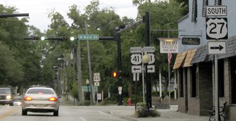
End of US highway 441

View a map showing this route.
Get your very own map showing all current and historic US routes!
Picture
Summa
Picture
Summa
1926-1935
  • North: Ocala, FL
  • South: Orlando, FL​​​
1935-1948
  • North: High Springs, FL
  • South: Orlando, FL​​​
1948-1949
  • North: Baldwin, GA
  • South: Orlando, FL​​​
1949-1952
  • North: Baldwin, GA
  • South: Miami, FL​​​
1952-present
  • North: Lake City/Rocky Top, TN
  • South: Miami, FL​​​
Mileage: in 1989 AASHTO listed a figure of 952 miles for US 441... however, that included the mileage of US 441's associated business routes.  According to the state subtotals on AASHTO's 1989 spreadsheet, mainline US 441's actual end-to-end total at the time was 936 miles.  That exactly matches our own 2020 measurement, which yielded 936.0 miles.  
However, if we subtract its implied route through Great Smoky Mountains National Park (which is not signed as US 441), the total is 904.4 miles.

Picture
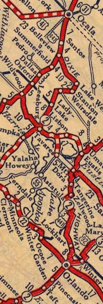
c. 1927, Rand McNally
US 441 was an original 1926 highway, but initially it ran only between Orlando and Ocala.  It is likely that US 441 originally came into Orlando via Edgewater Drive, and then used Lakeview Street to connect with Orange Avenue (which carried US 92).  The two routes probably overlapped down to the courthouse (which was on Central Avenue at the time), where US 441 ended, but US 92 continued down Orange towards Kissimmee.

By the 1930s, US 441 had been rerouted to follow its present alignment to the northwest (Orange Blossom Trail).  The earliest detailed map I have seen is 1936 (shortly after US 17 had been extended through Orlando, overlapped with US 92); the clarity was not very good, but it showed the same configuration as this 1939 map:
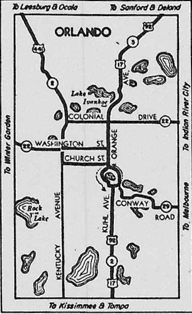
Picture
c. 1939, FDoT
US 441 turned off Orange Blossom onto Church Street, ending at US 17-92 (Orange Av).  This image shows a modern perspective of that intersection, looking east on Church at the historic south end of US 441:
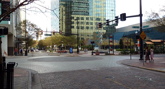
Picture
Karners, Jan. 2017
By the 1940s, Orange Blossom Trail was carrying highway traffic south of Orlando (as well as northwest), and Mills Avenue replaced Orange as the corridor for northbound travelers.  Robinson Avenue was used to connect Mills and Orange Blossom, so US 441 then ended where US 17-92 made that turn:
Picture
c. 1949, FDoT
This image is looking north on Orange Blossom; US 17-92 once turned to the right on Robinson, so the south beginning of US 441 was straight ahead:
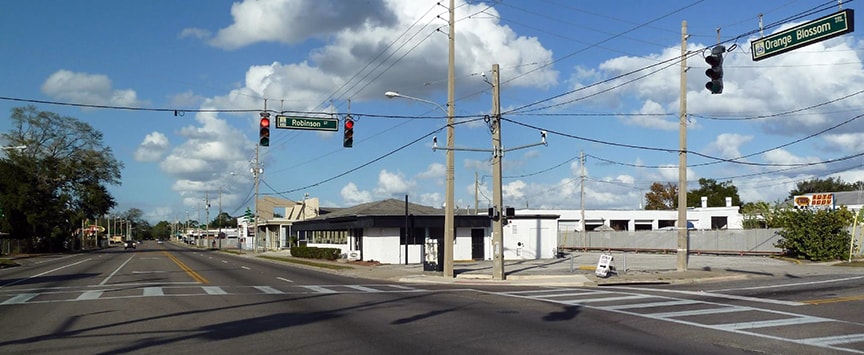
Picture
Karners, Jan. 2017

The original north end of US 441 was in Ocala.  In 1927, US 41 went through Gainesville and Ocala before heading back west through Dunnellon and Inverness.  In Ocala, US 41 came in from the north on Magnolia Street.  At Broadway Avenue, US 41 went west, but straight ahead on Magnolia was the north beginning of US 441.  This photo was looking the opposite direction (north on Magnolia).  Magnolia is one-way southbound now (despite the street sign for Broadway facing northbound traffic).  This was the original north end of US 441; straight ahead was northbound US 41, and southbound US 41 was to the left:
Picture
Droz, Dec. 2006
Picture
c. 1939, Rand McNally
In 1935 US 41 was rerouted along its current path through Newberry and Williston, so the US 441 designation was extended straight ahead (north along what had been US 41) to a new endpoint in High Springs.  It ended at its junction with US 41, right in the middle of town (Main Street and N. 1st Avenue).  This photo was looking east on 1st Av, or south on US 27-41:
Picture
Nitzman, June 2006
​US 27 turns right on Main with southbound US 41.  Straight ahead was once the north beginning of US 441.  That route now follows Santa Fe Boulevard, which joins 1st about six blocks ahead -- hence the "TO US 441" sign in the distance. 
In 1948, US 441 finally crossed a state line, when its north end was extended to Baldwin:
Picture
c. 1949, GA DoT
​This photo was taken looking norteast on Willingham Avenue.  This was once northbound US 23, and to the right on Stonepile Street was once the north beginning of US 441:
Picture
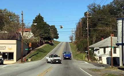
Sanderson, Nov. 2017

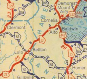
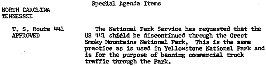
However, that lasted for only about three years, because in 1952 US 441 was extended north again.  It followed a 72-mile overlap with US 23 into North Carolina, then through Great Smoky Mountains National Park to its current terminus in Tennessee.  
At the time, the town where US 441 ends was called Lake City, but in 2014 its toponym was officially changed to Rocky Top:
Picture
c. 1956, Gousha
These photos show where US 441 ends, although there was no signage to make that clear: 
Picture
Sanderson, Oct. 2000
Picture
Sanderson, July 2007
US 25W is routed along Main Street/Main Avenue (it was impossible to tell which is correct, as the street signs in town were about evenly split between the two variations).  These shots show the north beginning of US 441 (or "Norris Freeway", which is not really much of a freeway by today's standards), as seen from US 25W (both southbound and northbound, respectively), as well as the first southbound confirming assembly:
Picture
Sanderson, July 2007
Picture
Elkins, Oct. 2008
Picture
Sanderson, July 2007
It should be noted: at the time of that 1952 extension into Tennessee, and for almost the next two decades, US 441 was signposted through Great Smoky Mountains National Park.  But at their November 1970 meeting, AASHO approved a National Park Service request to remove US 441 signs through the Park, and ever since then the route has had a gap in its signed mileage.  Here is an excerpt from the actual minutes of that meeting:
Picture

​Now, back to Florida: the 1949 map shown above was the last to indicate an Orlando endpoint for US 441, because that is when that route was extended to its current terminus in Miami.  Today US 441 heads due south from the Palm Beach area, parallel to the Atlantic Coast.  When it reaches the Miami area, it is routed down NW 7th Av.  The road jogs as it crosses the Miami River and becomes 8th Av.  US 441 ends at SW 8th Street, which carries US 41 traffic:
Picture
c. 1953, FDoT
Today US 441 crosses westbound US 41 at the one-way SW 7th St, but the US 441 designation still ends at SW 8th St, which carries eastbound US 41.  ​In these photos , the view is south on SW 8th Av, and the cross street is SW 8th St:
Picture
Cozart/Nitzman, May 2006
Picture
Karners, Dec. 2009
In 2006 there was no signage heralding the south beginning of US 441 from either 8th St or 7th St.  As of 2009, that was still true of 8th St, but a new signpost had been erected on 7th:
Picture
Karners, Dec. 2009
​Kind of interesting that southbound US 441 is mentioned there, since it ends one block in that direction. If you turn right, you'll immediately spot the first northbound confirming marker:
Picture
Karners, Dec. 2009

Research and/or photo credits: Bobby Clark; Justin Cozart; Robert Droz; Nathan Edgars; H.B. Elkins; Andy Field; Karin and Martin Karner; Dan Moraseski; Alex Nitzman; Dale Sanderson; Michael Summa
Page originally created 2000;
last updated Nov. 28, 2021.
Copyright © 1998-2022
Picture