End of US highway 84 |
 |
Summa
|
Summa
|
|
1926-1934
|
1934-1937
|
1937-1941
|
|
1941-1988
|
1988-present
|
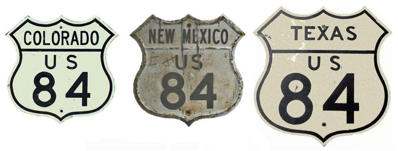
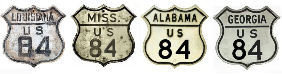
Mileage: in 1989 AASHTO listed a figure of 1930 miles for US 84... however, that included the mileage of US 84's associated business routes. According to the state subtotals on AASHTO's 1989 spreadsheet, mainline US 84's actual end-to-end total at the time was 1919 miles. That is reasonably close to our own 2016 measurement, which yielded 1905 miles (reroutings and realignments likely explain the difference). US 84's midway point is between Rusk and Palestine TX (nearest landmark is the Neches River bridge). For almost 50 years, when US 84 went to Brunswick, it was a little shorter: 1884 miles. During that time its midpoint was between Rusk and Maydelle.
|
US 84 was an original 1926 route, although at the time it ran only from Brunswick to Dothan (photos and more info on those pages). A 1934 Alabama map shows that US 84 had been extended across that state, but there was no bridge over the Tombigbee River west of Coffeeville. Instead, US 84 was directed south from Grove Hill (along US 43) to Wagarville, and then west on today's AL hwy. 56 to Chatom:
|
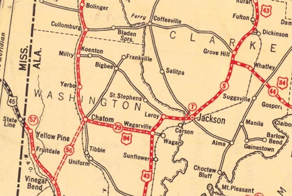
c. 1934, ALDoT
|
|
ALDoT maps all the way until about 1950 show US 84 ending there. However, this gap was apparently ignored, because 1935 was the first Mississippi map to show US 84 (although it was not shown east of Waynesboro):
c. 1935, MDoT
|
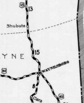
c. 1935, MDoT
|
What actually happened on the road was this: until about the mid-1950s, travelers heading east on US 84 were directed south from Waynesboro via US 45. At the town of State Line, US 84 traffic was directed east on AL 56 through Chatom to Wagarville. There, drivers were instructed to go north along US 43 to Grove Hill, and then resume eastward from there. (In 1965 AASHO approved the US 84 designation along the current direct route between Waynesboro and Grove Hill.)
|
|
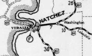
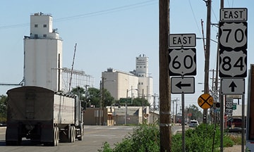
Despite the confusion around the AL/MS stateline, in 1934 AASHO had already extended the US 84 designation westward (including a ferry across the Mississippi at Natchez). At Muleshoe TX (northwest of Lubbock), US 84 joined with US 70, but for about three years it ended at its junction with US 60 in Texico NM:
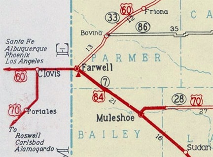
c. 1936, TXDoT
|
This photo is looking west on US 70-84, right at the stateline (so we are actually looking out of Farwell TX and into Texico NM):
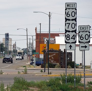
Sanderson, Aug. 2015
|
|
Westbound US 60 comes in from the right on State Street and continues straight ahead. That triple concurrency lasts for about 10 miles, until US 70 splits off at Clovis. But in 1934, US 84 ended here at its junction with US 60. This photo was taken looking the opposite direction (east on US 60-70-84):
|
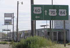
Teresco, Nov. 2003
|
Sanderson, Oct. 2015
|
US 60 splits off there, and straight ahead was once the west beginning of US 84... but not for long: in 1937 AASHO officially extended US 84 to Cortez CO, although it may not have been signposted beyond Santa Fe NM. Some commercial maps from that timeframe actually showed a gap in US 84 between Santa Fe and the Colorado line:
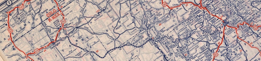
c. 1940, Rand McNally
From Cortez, the proposed route of US 84 was south on US 666 to Shiprock; east on US 550 to Aztec; southeast on NM 55 to La Jara; north and east on NM 96 to near Abiquiu; then southeast with US 285 to Santa Fe. But on that map, only the Colorado segment was labeled as US 84.
Perhaps it was during this timeframe that NMDoT made the decision to change the way it signed US 84. At any rate, today the "west" end of US 84 is technically at Ft. Sumner, because to the north and west from there, NM signs it as a north-south route. This makes sense north of Santa Fe, but it should have been left east-west between Santa Fe and Ft. Sumner. This would better address the situation west of Las Vegas, where as it stands currently, "northbound" US 84 travels in a decidedly southward direction. However, there is no risk of confusion due to directional signage, because that segment is overlapped with I-25, and NM does not dual-sign US 84 along there.
Perhaps it was during this timeframe that NMDoT made the decision to change the way it signed US 84. At any rate, today the "west" end of US 84 is technically at Ft. Sumner, because to the north and west from there, NM signs it as a north-south route. This makes sense north of Santa Fe, but it should have been left east-west between Santa Fe and Ft. Sumner. This would better address the situation west of Las Vegas, where as it stands currently, "northbound" US 84 travels in a decidedly southward direction. However, there is no risk of confusion due to directional signage, because that segment is overlapped with I-25, and NM does not dual-sign US 84 along there.
|
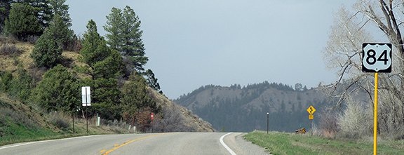
In 1941, the US 84 designation was extended north from Santa Fe to its current terminus on the edge of Pagosa Springs. Colorado does not use directional tabs anywhere on its 28-mile segment of US 84, but the zero milepost is at the state line, which would not be the case if CDoT considered it to be an east-west route. So US 84 is north-south for its westernmost 315 miles (from Ft. Sumner to Pagosa), meaning Pagosa is actually the "north" end of the route. Heading that direction, the last US 84 trailblazer is posted at the Rito Blanco bridge, nine miles before the route terminates:
|
Sanderson, Apr. 2015
|
|
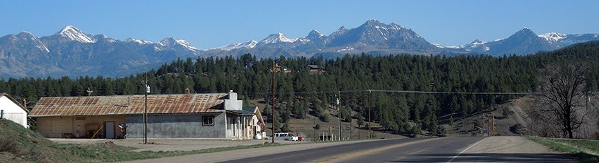
Heading north on US 84 brings travelers ever closer to the San Juan Mountains, and the panorama shown below fills the windshield just before descending into Pagosa...
|
Sanderson, Apr. 2015
|
|
...but since US 160 runs along the San Juan River, US 84 drops down into the valley just ahead, and as a result those mountains are not visible from the junction that marks the highway's terminus:
|
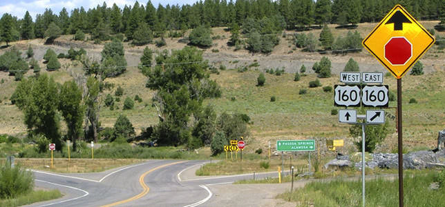
Sanderson, July 2004
|
|
US 84 ends there; downtown Pagosa is about a half-mile to the left. This photo shows the signage from westbound US 160 at the beginning of US 84:
|
Sanderson, Apr. 2015
|
|
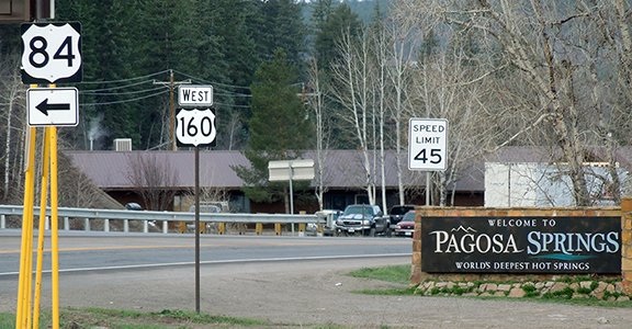
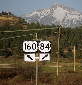
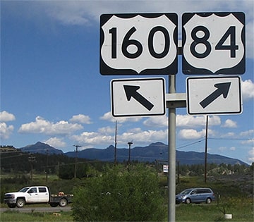
In these photos, the perspective is from the opposite direction (eastbound on US 160):
|
Faye and Sandy, Aug. 2003
|
Sanderson, Apr. 2015
|
|
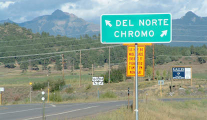
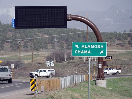
Note that the control cities have changed. The peaks visible in the distance are part of the south San Juans. Drivers must cross those via spectacular Wolf Creek Pass in order to reach Del Norte and Alamosa; the large VMS sign is probably most often used to warn drivers of winter conditions on that pass. US 84 begins to the right; the sign assembly in the gore is enlarged here:
|
Sanderson, Apr. 2015
|
Dienhart, Sep. 2022
|
If one takes that right turn, they will not immediately see a US 84 confirming marker. The first southbound trailblazer is essentially right across the road from the last northbound sign, which is about nine miles away from Pagosa.
Research and/or photo credits: Alan Beard; Paul Dienhart; Alan Hamilton; J.P. Nasiatka; Matt Salek; Dale Sanderson; Faye and Sandy; Michael Summa; Jim Teresco; Steve Williams
Page originally created 1999;
last updated Dec. 31, 2023.
last updated Dec. 31, 2023.
