End of US highway 59 |
 |
Summa
|
Summa
|
|
1934-1939
|
1939-1953
|
1953-present
|
|
Mileage: AASHTO's latest route log (1989) listed US 59 as 1911 miles. Our own 2020 measurement yielded 1912.5 miles in total length. The midway point of US 59 is in Chetopa, Kansas.
|
|
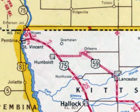
The 1934 Minnesota official state highway map showed a US 59 starting at Lake City and heading south to the Iowa line, but that route was never approved by AASHO, and was never signposted as US 59 (later in 1934 AASHO designated that route as an extension of US 63). That was the same year that the "real" US 59 was commissioned, and it has been around ever since. Until 1953 it headed northwest from Lancaster, joining US 75 near Humboldt:
c. 1953, MNDoT
|
c. 1957, MNDoT
|
|
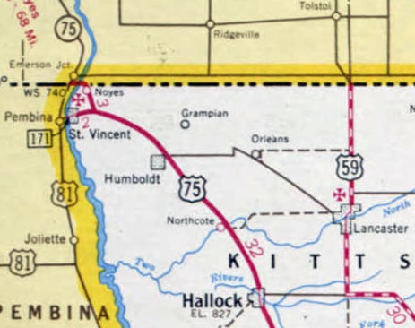
But instead of continuing with US 75 to the Canada border at Noyes MN, US 59 split off at St. Vincent and crossed over to Pembina. It appears US 59 ended right in Pembina at its junction with US 81 (rather than continuing with US 81 up to the border crossing). In 1953, the north end of US 59 was changed to the route it still follows today: it heads due north out of Lancaster about nine miles, terminating at the port of the same name on the Canada border:
|
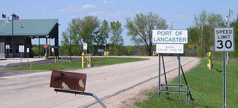
Morrison, May 2007
|
|
The road continues ahead as Manitoba hwy. 59, to Winnipeg and beyond. Heading the opposite direction, this photo shows the first southbound US 59 marker:
|
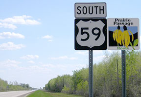
Morrison, May 2007
|
Originally, from Tenaha TX, US 59 followed what is now US 96 down to its south end at Port Arthur. In 1939 the US 59 designation was truncated at Tenaha and rerouted south and west along essentially the same path it currently follows to Beeville (more about that on this blog post). However, today's US 59 between there and Laredo had not yet been built, so US 59 traffic was routed along what is now TX hwy. 359 via Skidmore, Mathis, Alice, San Diego, and Hebbronville; view the Laredo page for more info about its historic endpoint there.
|
In about 1955, today's US 59 between Beeville and Laredo was opened to traffic, so US 59 now comes into town from the northeast. But historically it continued farther west on Saunders Street. This photo shows what was formerly the last US 59 sign:
|
Taylor, 2000 (gone as of 2014)
|
|
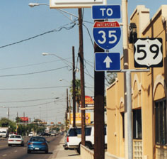
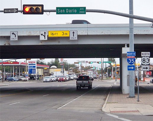
The overpass in the distance is I-35/US 83, and the US 59 designation ended at that interchange... but first, Saunders crosses Zacata Creek. Throughout Laredo, the street grid is offset on opposite sides of this creek, so Saunders jogs slightly to the north and becomes Lafayette Street just before it reaches I-35. The frontage road on this side (the east side) of the freeway is San Dario Avenue. Technically, US 59 ended at the intersection on the far side of the freeway (Santa Ursula Avenue, the next signal), because that frontage road provides access to southbound I-35/US 83:
|
Karners, Dec. 2014
|
|
There was no good reason why the US 59 designation shouldn't have continued just one more block past there, to San Bernardo Avenue, which was the original US 81-83 through the city, and which now carries Bus. 35 and Bus. 83. In fact, that junction is signed as if Lafayette is on the state highway system...
|

Google Maps Street View, Dec. 2012
|
|
...and for San Bernardo traffic, Lafayette was signed as if it was the south beginning of US 59:
|

Google Maps Street View, Dec. 2012
|
|
That was from southbound San Bernardo; an identical sign was posted for northbound traffic. The 1961 TXDoT map of Laredo shows that US 59 extended straight ahead (south on San Bernardo, co-signed with US 81 and US 83). But US 59 was probably truncated when US 81-83 traffic was moved to the freeway, so US 59 began to the left for about 50 years. Signage on southbound Santa Ursula looked the same as southbound San Bernardo:
|

Karners, Dec. 2014
|
|
Turning that direction (east on Lafayette), the first confirming marker was posted just on the other side of the I-35 overpass:
Karners, Dec. 2014
|
Heading north on I-35, this shot shows the signage for the exit to the beginning of US 59:
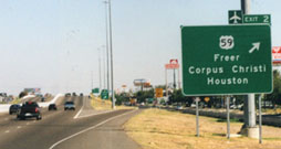
Taylor, 2000 (unchanged as of Oct. 2007)
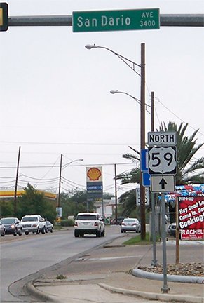
That off-ramp leads to San Dario (the frontage road), and at the stoplight at Lafayette the sign tree shown here was formerly posted:

Taylor, 2000 (gone as of 2014)
|
Note that back then, US 59 was signed as an east-west highway. It is unclear where signage changed to north-south: I figured maybe Houston, and someone else suggested Beeville. At any rate, by 2004 signs along the entire route had been changed to north-south, including those in Laredo. This could have been confusing to some drivers, since US 59 did start out by heading due east.
|
At their Spring 2014 meeting, AASHTO approved Texas' request to reroute US 59 around the north segment of Loop 20, to a new terminus at the World Trade International Bridge. They also approved the request to re-designate old US 59 as Business 59. It appears TXDoT changed signage to that effect approx. one year later. This shot was looking west on Saunders at its junction with the Bob Bullock Loop:
|

Google Maps Street View, Aug. 2015
|
Originally Bob Bullock was signed only as Loop 20, but in 2015 the US 59 designation was added to the northern portion of the loop, and former mainline 59 (ahead on Saunders) was re-signed as Business 59. US 59 now follows the Loop to the north, which then turns west again to Laredo's newest international port of entry:
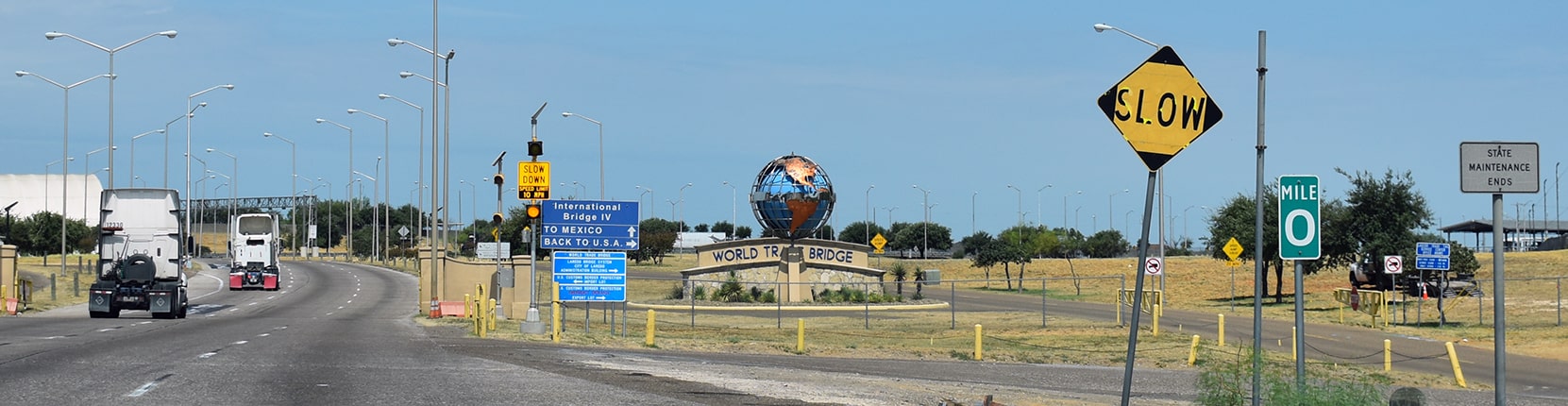
Ivy/Nitzman, Aug. 2018
|
That was taken right at the last turnaround that allows one to stay in the U.S. instead of committing to going through the border checkpoint. At far right, note the "Mile 0" marker and the "State Maintenance Ends" signs (those refer to US 59 as well as I-69W, which are concurrent at this point). The monument in the background is a stylized globe, and it includes the words "World Trade Bridge".
Heading the opposite direction (coming in from Mexico), the first overhead sign includes the first confirmation for northbound US 59: |
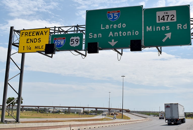
Ivy/Nitzman, Aug. 2018
|
Research and/or photo credits: Brent Ivy; Karin and Martin Karner; Jeff Morrison; Alex Nitzman; Steve Riner; Dale Sanderson; Michael Summa; Stephen Taylor
Page originally created 2000;
last updated Dec. 17, 2023.
last updated Dec. 17, 2023.
