US Ends .com
  • Home
  • Store
    • US highway book
    • US highway map
    • Florida US highway map
  • Endpoints
    • US 1 - US 9 >
      • 1 >
        • 201
        • 301
        • 401 [i]
        • 401 [ii]
        • 401
        • 501
        • 601
        • 701
      • 2w >
        • 102
      • 2e >
        • 202
        • 302
      • 3
      • 4 >
        • 104
      • 5
      • 6 >
        • 106
        • 206
      • 7
      • 8
      • 9 >
        • 109*
        • 209
        • 309
    • US 10 - US 19 >
      • 10 >
        • 110
        • 210
        • 310
        • 410
      • 11 >
        • 111
        • 211
        • 311
        • 411 [i]
        • 411 [ii]
        • 411
        • 511*
        • 611
        • 711*
      • 12 >
        • 112
        • 212
        • 312
      • 13 >
        • 113
        • 213
      • 14
      • 15
      • 16 >
        • 116
        • 216
      • 17 >
        • 17-1
        • 117 [i]
        • 117
        • 217
      • 18 >
        • 118
        • 218
      • 19 >
        • 119
        • 219
        • 319
    • US 20 - US 29 >
      • 20e >
        • 120
        • 220
        • 320
        • 420
      • 20w
      • 21 >
        • 121 [i]
        • 121
        • 221
        • 321
        • 421
        • 521
      • 22 >
        • 122 [i]
        • 122 [ii]
        • 222
        • 322
        • 422e
        • 422w
        • 522
        • 622*
      • 23 >
        • 123 [i]
        • 123
        • 223
      • 24 >
        • 124
        • 224
      • 25
      • 26 >
        • 126
      • 27 >
        • 127
        • 227
      • 28
      • 29 >
        • 129
    • US 30 - US 39 >
      • 30 >
        • 130
        • 230
        • 330
        • 430
        • 530
        • 630*
        • 730
        • 830
      • 31 >
        • 131
        • 231
        • 331 [i]
        • 331
        • 431
      • 32
      • 33
      • 34
      • 35
      • 36 >
        • 136
      • 38 >
        • 138
    • US 40 - US 49 >
      • 40 >
        • 140
        • 240
        • 340
      • 41 >
        • 141
        • 241 [i]
        • 241 [ii]
        • 341
        • 441 >
          • 441n
          • 441s
        • 541
        • 641
      • 42
      • 43
      • 44
      • 45
      • 46
      • 48 [i]
      • 48 [ii]
      • 48
      • 49
    • US 50 - US 59 >
      • 50 >
        • 150
        • 250
        • 350
        • 450
        • 550
        • 650
      • 51 - 55 >
        • 51 >
          • 151
        • 52 >
          • 152
        • 53
        • 54 >
          • 154
        • 55
      • 56 >
        • 156
      • 57
      • 58 >
        • 158
        • 258
      • 59 >
        • 159
        • 259
    • US 60 - US 69 >
      • 60 >
        • 160
        • 260
        • 360
        • 460
      • 61 - 65 >
        • 61 >
          • 161
        • 62
        • 63 >
          • 163 [i]
        • 64 >
          • 164 [i]
          • 164 [ii]
          • 264
        • 65 >
          • 165
      • 66 >
        • 166
        • 266
        • 366 [i]
        • 366 [ii]
        • 466 [i]*
        • 466 [ii]
        • 566
        • 666
      • 67 >
        • 167
      • 68 >
        • 168
      • 69 >
        • 169
    • US 70 - US 79 >
      • 70 >
        • 170
        • 270 [i]*
        • 270
        • 370
        • 470
      • 71 >
        • 171
        • 271
        • 371 [i]
        • 371 [ii]
        • 371
      • 72 - 76 >
        • 72
        • 73
        • 74
        • 75 >
          • 175
          • 275
        • 76 >
          • 176
          • 276
      • 77 >
        • 177
        • 277
        • 377
      • 78 >
        • 178
        • 278
        • 378
      • 79
    • US 80 - US 89 >
      • 80 - 84 >
        • 80 >
          • 180 [i]
          • 180
          • 280
          • 380
        • 81 >
          • 181
          • 281
        • 82
        • 83 >
          • 183
          • 283
          • 383
        • 84
      • 85 - 89 >
        • 85 >
          • 185
          • 285 [i]
          • 285
          • 385 [i]
          • 385
          • 485
        • 87 >
          • 187
          • 287n
          • 287s
        • 89n
        • 89s >
          • 189 [i]
          • 189
    • US 90 - US 99 >
      • 90 - 94 >
        • 90 >
          • 190
          • 290
        • 91 >
          • 191 >
            • 191n
            • 191s
          • 491
        • 92 >
          • 192
        • 93
        • 94
      • 95 -98 >
        • 95 >
          • 195
          • 295
          • 395
        • 96 [i]
        • 96
        • 97 >
          • 197
        • 98
      • 99 >
        • 199
        • 299
        • 399
    • Anomalies >
      • 101
      • 163
      • 400
      • 412
      • 425
  • Places
    • A-L >
      • A >
        • Aberdeen
        • Albuquerque
        • Amarillo
        • Apalachicola
        • Astoria
        • Atlantic
      • B >
        • Baltimore
        • Baton Rouge
        • Bay Area
        • Bishop
        • Boone
        • Brady
        • Bristol
        • Brownsville
        • Brunswick
      • C >
        • Charleston
        • Chattanooga
        • Chicago
        • Cincinnati
        • Cleveland
        • Cody
        • Corpus
        • Cortez
        • Council Bluffs
        • Covington
        • Crescent
        • Cumberland Gap
      • D-E >
        • Dallas
        • Des Moines
        • Detroit
        • Dothan
        • Douglas
        • El Paso
        • Erie
        • Eugene
      • F >
        • Farmington
        • Flagstaff
        • Florence
        • Fox Valley
        • Franklin
      • G >
        • Gallup
        • Georgetown
        • Grand Junction
        • Grand Portage
        • Grayling
        • Great Falls
        • Greeley
      • H-I >
        • Hardeeville
        • Harrisburg
        • Holbrook
        • Idaho Falls
        • Int'l Falls
      • J-K >
        • Jacksonville
        • Joplin
        • Junction
        • Kansas City
        • Keokuk
        • Key West
        • Kingman
      • L >
        • Laredo
        • Lewiston
        • Long Beach
        • Los Angeles
        • Louisville
        • Lubbock
    • M-R >
      • M >
        • Mackinaw
        • Madison
        • Maryhill
        • Maysville
        • Miami
        • Midway
        • Miles City
        • Milford
        • Milwaukee
        • Minneapolis
        • Mobile 31
        • Mobile 31-43-45
        • Montgomery
        • Monticello
        • Mount Vernon
      • N-O >
        • Nags Head
        • Naples
        • Natchez
        • New Castle
        • New Orleans
        • Niagara
        • Norlina
        • Ocean City
        • Oklahoma City
      • P >
        • Pee Dee
        • Pembina
        • Pensacola
        • Petersburg
        • Philadelphia
        • Piegan
        • Pineville
        • Port Arthur
        • Portsmouth
      • Q-R >
        • Quad Cities
        • Rapid City
        • Raton
        • Reading
        • Richmond
        • Rockingham
        • Rouses Point
    • S-Z >
      • S >
        • San Antonio
        • San Antonio NM
        • San Diego
        • Santa Fe
        • Savannah
        • Sioux
        • Springer
        • Springfield
        • St. Ignace
        • St. John
        • St. Paul
        • St. Pete
      • T-U-V >
        • Tallahassee
        • Tampa
        • Toledo
        • Trinidad
        • Tuba City
        • Ucolo
        • VA Beach
      • W >
        • Walterboro
        • Waverly
        • West Memphis
        • Wilmington
        • Wilson
        • Wrightsville
      • Y >
        • Yellowstone E
        • Yellowstone N
        • Yellowstone NE
        • Yellowstone S
        • Yellowstone W
  • Highways
    • Map of all endpoints
    • Sources
    • History
    • 1926 almost-routes
    • Intra-state routes
    • Numbering
    • Colors
    • Gaps
    • Blog
  • Bonus
    • Colorado >
      • Lowest point
      • Antipodes
      • Toponymy >
        • Roots
      • Colloquialisms
      • Populations
      • Denvers
    • Washington Meridian
    • Watersheds >
      • Headwaters Hill
      • Three Waters Mtn.
      • Parting of the Waters
    • Geo-centers >
      • 48 states
      • 50 states
      • North America
    • State corners >
      • AZ-CO-NM-UT
      • CO-UT-WY
      • CO-NE-WY
      • CO northeast
      • CO-KS-NE
      • CO-KS-OK
      • CO-NM-OK
      • NM-OK-TX
      • NM southeast
      • TX northwest
  • Connect
    • Author/history
    • Rationale
    • Contact
    • Contributors
    • Submissions

End of historic US highway 285 [i]

View a map showing this route.
Get your very own map showing all current and historic US routes!
Picture
Summa
1926-1934
  • North: Laramie, WY
  • South: Denver, CO
US 285 measured approximately 130 miles in total length.
Get your copy of this epic book that commemorates the first century of the US route system!

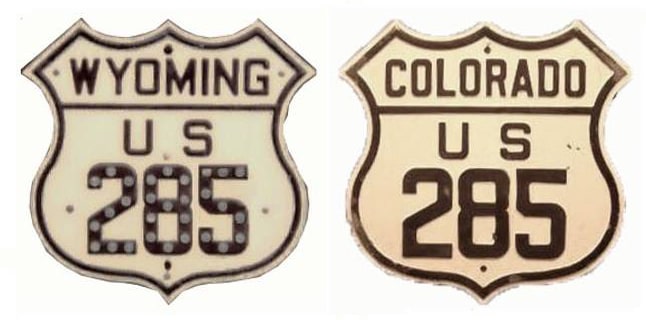
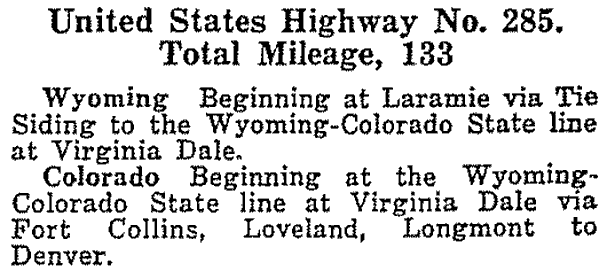
US 285 [i] was among the original 1926 US highway routes; it essentially followed what is now US 287 between Denver and Laramie.  ​This excerpt is from AASHO's Apr. 1927 route log:
Picture
Picture
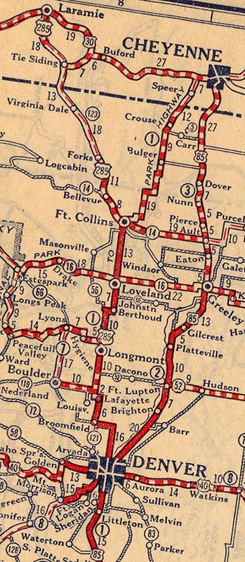
c. 1927, Rand McNally
But in Laramie, traffic did not come in on 3rd Street (as US 287 does today).  Rather, US 285 used Fort Sanders Road on the south end of town.  Historically that extended further north, and right about where I-80 is now, it became 2nd Street.  US 285 followed that up to Grand Avenue, then turned east one block, and ended at 3rd, where it had a junction with US 30.  
This photo was looking north on 3rd; Grand is the next intersection.  The north beginning of US 285 was to the left; to the right was (and is) eastbound US 30, while westbound is straight ahead:
Picture
Sanderson, May 2001
This shot was looking the opposite direction -- south on 3rd -- which at this point serves as US 30 and US 287.  But US 287 did not come through here until 1936.  Before that, US 285 began to the right on Grand, where US 30 turns left:
Picture
Sanderson, May 2001
This last shot was looking west on Grand; historically US 285 [i] began straight ahead:
Picture
Sanderson, May 2001

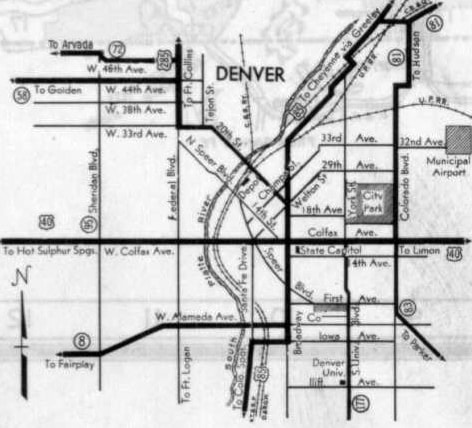
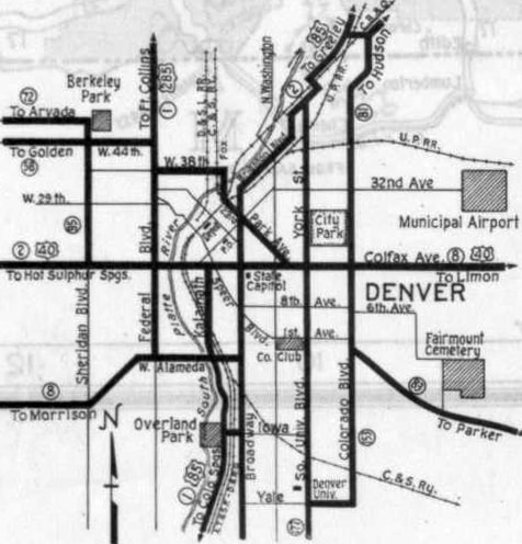
US 285 has always had one end in Denver.  But until 1936, Denver was the southern terminus of US 285 -- not its northern terminus, as it is now (more on the current US 285 page).  US 285 [i] existed for only about eight years, and its south end in Denver was continually migrating during that time:
Picture

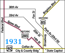
This next map shows the original south end of 285, starting in 1927...
Picture
c. 1931, CDoT
...although that was a generalized depiction of Speer Boulevard, 14th Street, and how they connected.  The actual road alignments were more accurately shown on this commercial map (this was actually a few years after US 285 had been changed to US 287, and no US routes followed Speer any longer, but it still shows Speer's original corridor):
Picture
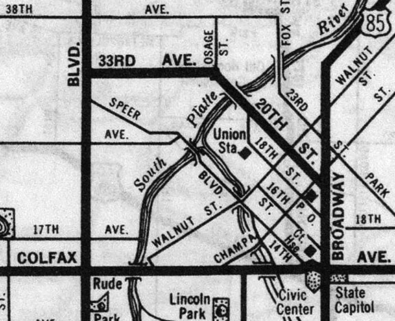
c. 1940, Rand McNally
Heading southeast from Federal Boulevard, Speer initially jogged around a bit.  Specifically, after crossing Zuni Street, Speer went due east along the original 27th Avenue (no longer extant), to about where I-25 is now.  Then traffic could resume southeastward again, right through what is now Confluence Park, running a bit closer to Cherry Creek than today's Speer Blvd.  This was along the old 14th Street Viaduct (which opened in 1899, and was demolished in 1988, long after its functionality had been replaced by modern Speer Blvd).  This animated map allows comparison between the original and current alignments of Speer:
Picture
USGS
At about Blake Street, US 285 traffic crossed over Cherry Creek, and then resumed southeastward along the segment of 14th that still exists.  Colfax Avenue has carried US 40 traffic from the time the US routes were first designated (it now carries US 287 as well).  In this photo, taken looking southeast on 14th at Colfax, a sharp right leads to westbound Colfax; an easy right goes to southbound Bannock Street; and an easy left puts drivers on eastbound Colfax:
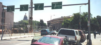
Picture
Sanderson, 2000
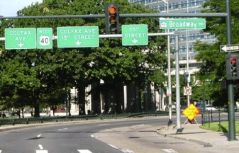
Two blocks to the left is Broadway, which historically carried US 85 traffic.  Technically, US 285 should have overlapped with US 40 east on Colfax from 14th to Broadway (in order to connect with its parent route, US 85).  But since that is such a short distance, it may be very difficult to find an historic map at a large enough scale to show whether or not that was actually the case.  If it was, then US 285 originally ended at the intersection shown here.  This is the view from eastbound Colfax at Broadway (with the State Capitol in the background):
Picture
Sanderson, 2000
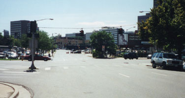
At the time it was a common practice to signpost all routes from a prominent public building, and in Denver it certainly would have made sense to begin signing US 285 from the Capitol, where two major US routes junctioned.  So this shot, looking the opposite direction (west on Colfax) likely shows the original south beginning of US 285:
Picture
Sanderson, 2005
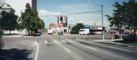
One block in that direction (two today, after a realignment), US 285 split off from US 40 to head northwest on 14th.  Drivers cannot do that anymore, as 14th is one-way southeastbound today.  This scene bears very little resemblance to the view of a traveler in the early 1930s, but the cars at far left are on eastbound Colfax, and 14th St (historic US 285) recedes into the distance:
Picture
Sanderson, 2000
​That was US 285's route for at least five years.  Then in about 1933, US 285's route into downtown was changed.  From Federal, traffic was directed east on 33rd Avenue to Osage Street, where US 285 turned southeast on the no-longer-extant 20th Street viaduct (which aligned with the current 20th Street near Chestnut Place):
Picture
c. 1934, CDoT
This shot shows the second endpoint of US 285 [i]; we are looking southeast on 20th at Broadway.  A third street (California Avenue) runs through that intersection, confusing the perspective.  The black SUV (under the billboard) was northbound on Broadway, while the red car (behind the traffic signal) was southwest on California:
Picture
Sanderson, 2000
This photo, looking the opposite direction, may be a bit more instructive.  It was taken looking northwest on 20th, at a former beginning of US 285.  The white delivery truck and the bus were southbound on Broadway (old US 85).  The gray suv at far right was southwest on California:
Picture
Sanderson, 2000

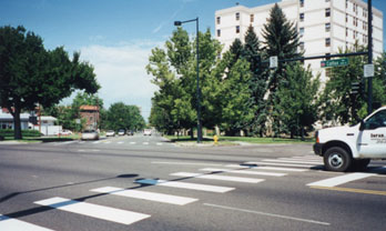
​That lasted for only about one year.  Then the route of US 285 was shifted again -- this time down Park Avenue (which is the equivalent of 23rd Street):
Picture
c. 1935, CDoT
This photo shows the final endpoint of US 285 [i], at Park Av and Colfax (US 40).  We are looking southeast on Park.  The double turn goes to eastbound Colfax, while an easy right leads to southbound Franklin Street:
Picture
Sanderson, 2000
This shot was from the opposite perspective.  The truck was on westbound Colfax.  To the right of the large building is northbound Franklin; to its left is northwestbound Park Av, and the final south beginning of US 285 [i]:
Picture
Sanderson, 2000
Some maps from the following year (1936) indicated that intersection had become the south end of US 287, but the official state highway map from 1936 showed that the former US 285 between Ft. Collins and Denver had become US 87, and that US 287 ended in Ft. Collins.  The number "285" had been recycled for a new US route running south and west from Denver: the US 285 familiar to us today.

Research and/or photo credits: Nathan Edgars; Dale Sanderson; Michael Summa
Page originally created 2000;
last updated Dec. 4, 2023.
Copyright © 1998-2025
Picture