Historic US highway endpoints in Miami, FL |
 |
|
US 94 was an original 1926 highway. There was a good reason for its existence: the road from Naples to Miami is east-west, so it was proper to assign it an east-west number. Originally there were three US routes serving southern Florida, forming a "U" shape in the lower peninsula. US 1 went south to its original endpoint in Miami, which was also the east beginning of US 94. That route went west to Naples -- its endpoint there was at the same place where US 41 began. And US 41 went north from Naples, serving Florida's Gulf Shore:
|
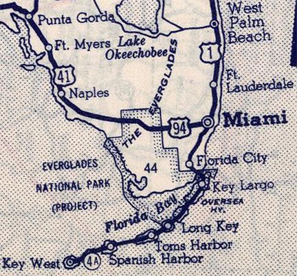
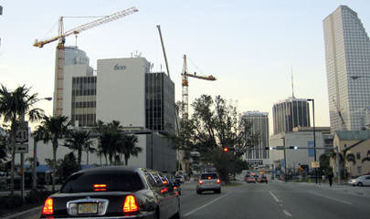
c. 1940, Rand McNally
|
At the time that the US routes were initially signposted, Biscayne Boulevard had not been built; instead, US 1 traffic came into Miami via NE 2nd Avenue. But also, Brickell Avenue did not have a bridge across the Miami River; early Automobile Blue Book maps suggest that traffic was directed west on Flagler Street, and then south on Miami Avenue to cross the river. So where did US 1 end during that time?
|
|
In the 1920s and '30s, it was common for highway designations to terminate at government buildings, such as the city hall or the county courthouse. For this reason, I suspect that both US 1 and US 94 originally began at the intersection of Miami and Flagler (which is one block east of the Dade County Courthouse, construction on which began in 1925). US 1 would have started out heading east on Flagler, then north on NE 2nd; while US 94 would have started heading south on Miami, then west on SW 8th Street. This photo was taken looking east on Flagler:
|
Karners, Dec. 2016
|
|
Possibly US 1 began straight ahead, while US 94 began to the right on Miami. Wherever those routes originally terminated, that situation was very short-lived, because Biscayne was built in 1928, and the Brickell bridge opened in 1929. So probably the current highway routings were already beginning to take shape by the early '30s. US 1 followed Biscayne, then Brickell, ending at SW 8th, which is the same intersection where US 94 began:
|
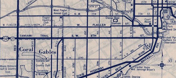
c. 1940, Rand McNally
|
The 1938 photograph below was taken looking south on Brickell. At the time, this was the south end of US 1 (straight ahead was the north beginning of FL 4-A, which went to the Florida Keys). The east beginning of US 94 was to the right (west) on SE 8th Street; a street blade is visible at upper right. On that same signpost was a sign noting "Ta-Miami Trail". That was another name for US 94, because the road connected Tampa and Miami (although I think it was more common to see it spelled without a hyphen, i.e. "Tamiami Trail"). On the signpost in the foreground, the shield with an "R" was used to indicate a right turn:
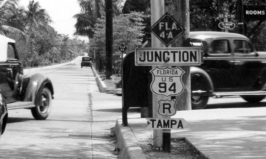
Hillers, c. 1938 (linked to source)
|
It is fortunate that photo was taken when it was, because the very next year (1939) US 1 was extended further southward from Miami (along FL 4-A shown above), ending in Key West. However, that did not affect US 94's endpoint. It was not until 1950 that the US 94 designation was decommissioned, when US 41 was extended from Naples east to Miami along the former US 94. (Reportedly that segment of US 41 was originally signed "East" and "West", but now US 41 is signed east-west only in Miami/Dade County.) About two years later, in 1952, the US 41 designation was extended north and east about six miles to its current terminus in Miami Beach. However, beginning in 2000, FDoT decided to remove all US 41 references east of its junction with US 1. So even though US 41 officially still went to Miami Beach, FDoT posted "End US 41" assemblies at Brickell (US 1). In other words: US 41's signed endpoint was at the same location as US 94's historic terminus. This photo was looking east on SW 8th at Brickell (or US 1) in Miami:
|
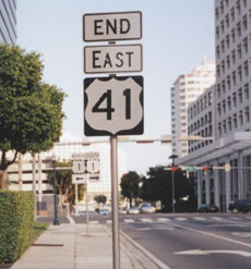
Osbaldeston, Mar. 2001
|
|
Since that is a one-way street, there was an identical assembly on the opposite side of the road as well:
|
Field/Nitzman, Dec. 2003
|
|
That intersection is also the historic east end of US 94, and to the left on Brickell is a former south beginning of US 1. (Today 8th is one-way eastbound, so now the "west" beginning of US 41 is at 7th Street, one block to the left.) Historically, signage at that junction looked like this:
|
Florida DoT's photolog system, 1994
|
|
(Info about those strange colored shields.) In this next photo, the faded paint on the sign had rendered it pretty much illegible, but it was the first US 41 marker heading west from US 1:
|
Florida DoT's photolog system, 1994
|
|
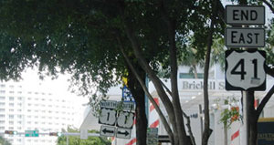
Back to modern signage: here is a view of what the signed east beginning of US 41 looks like, as seen from what was northbound US 1 at the time:
|
Cozart/Nitzman, Mar. 2006
|
US 41 ostensibly begins to the left on 7th, while straight ahead was an early south beginning of US 1. The sign in the median at far left is a little hard to see, but there was an identical one across the street, on the right side of the road:
|

Karners, Dec. 2009
|
In 2013, FDoT sought and received approval to remove US 1 traffic from Brickell, instead rerouting it along I-95. At that time, they removed the "End US 41" assemblies, but made no other changes to US 41 references, not even those posted along Brickell.
|
As of 2020, both signposts were still there, although the left arrow was missing from the one on the right-hand side of Brickell:
|
Ivy/Nitzman, Mar. 2020
|
|
That also represents the historic east beginning of US 94, although back when it existed, 8th St carried both directions of traffic. If a driver turns that way, they will soon see the first westbound confirming marker:
|
Ivy/Nitzman, Mar. 2020
|
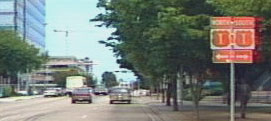
After a few miles, that direction begins to be signed as "North", and that remains the case for the rest of the 2000-mile journey to Lake Superior along the second-longest north/south US route.
Research and/or photo credits: Justin Cozart; Nathan Edgars; Andy Field; Mike Heidenreich; J.K. Hillers; Brent Ivy; Karin and Martin Karner; Dan Moraseski; Alex Nitzman; Greg Osbaldeston; Mike Roberson; Dale Sanderson
Page originally created 2001;
last updated Dec. 11, 2023.
last updated Dec. 11, 2023.
