US Ends .com
  • Home
  • Store
    • US highway map
    • Florida US highway map
  • Endpoints
    • US 1 - US 9 >
      • 1 >
        • 201
        • 301
        • 401 [i]
        • 401 [ii]
        • 401
        • 501
        • 601
        • 701
      • 2w >
        • 102
      • 2e >
        • 202
        • 302
      • 3
      • 4 >
        • 104
      • 5
      • 6 >
        • 106
        • 206
      • 7
      • 8
      • 9 >
        • 109*
        • 209
        • 309
    • US 10 - US 19 >
      • 10 >
        • 110
        • 210
        • 310
        • 410
      • 11 >
        • 111
        • 211
        • 311
        • 411 [i]
        • 411 [ii]
        • 411
        • 511*
        • 611
        • 711*
      • 12 >
        • 112
        • 212
        • 312
      • 13 >
        • 113
        • 213
      • 14
      • 15
      • 16 >
        • 116
        • 216
      • 17 >
        • 17-1
        • 117 [i]
        • 117
        • 217
      • 18 >
        • 118
        • 218
      • 19 >
        • 119
        • 219
        • 319
    • US 20 - US 29 >
      • 20e >
        • 120
        • 220
        • 320
        • 420
      • 20w
      • 21 >
        • 121 [i]
        • 121
        • 221
        • 321
        • 421
        • 521
      • 22 >
        • 122 [i]
        • 122 [ii]
        • 222
        • 322
        • 422e
        • 422w
        • 522
        • 622*
      • 23 >
        • 123 [i]
        • 123
        • 223
      • 24 >
        • 124
        • 224
      • 25
      • 26 >
        • 126
      • 27 >
        • 127
        • 227
      • 28
      • 29 >
        • 129
    • US 30 - US 39 >
      • 30 >
        • 130
        • 230
        • 330
        • 430
        • 530
        • 630*
        • 730
        • 830
      • 31 >
        • 131
        • 231
        • 331 [i]
        • 331
        • 431
      • 32
      • 33
      • 34
      • 35
      • 36 >
        • 136
      • 38 >
        • 138
    • US 40 - US 49 >
      • 40 >
        • 140
        • 240
        • 340
      • 41 >
        • 141
        • 241 [i]
        • 241 [ii]
        • 341
        • 441 >
          • 441n
          • 441s
        • 541
        • 641
      • 42
      • 43
      • 44
      • 45
      • 46
      • 48 [i]
      • 48 [ii]
      • 48
      • 49
    • US 50 - US 59 >
      • 50 >
        • 150
        • 250
        • 350
        • 450
        • 550
        • 650
      • 51 - 55 >
        • 51 >
          • 151
        • 52 >
          • 152
        • 53
        • 54 >
          • 154
        • 55
      • 56 >
        • 156
      • 57
      • 58 >
        • 158
        • 258
      • 59 >
        • 159
        • 259
    • US 60 - US 69 >
      • 60 >
        • 160
        • 260
        • 360
        • 460
      • 61 - 65 >
        • 61 >
          • 161
        • 62
        • 63 >
          • 163 [i]
        • 64 >
          • 164 [i]
          • 164 [ii]
          • 264
        • 65 >
          • 165
      • 66 >
        • 166
        • 266
        • 366 [i]
        • 366 [ii]
        • 466
        • 566
        • 666
      • 67 >
        • 167
      • 68 >
        • 168
      • 69 >
        • 169
    • US 70 - US 79 >
      • 70 >
        • 170
        • 270 [i]*
        • 270
        • 370
        • 470
      • 71 >
        • 171
        • 271
        • 371 [i]
        • 371
      • 72 - 76 >
        • 72
        • 73
        • 74
        • 75 >
          • 175
          • 275
        • 76 >
          • 176
          • 276
      • 77 >
        • 177
        • 277
        • 377
      • 78 >
        • 178
        • 278
        • 378
      • 79
    • US 80 - US 89 >
      • 80 - 84 >
        • 80 >
          • 180 [i]
          • 180
          • 280
          • 380
        • 81 >
          • 181
          • 281
        • 82
        • 83 >
          • 183
          • 283
          • 383
        • 84
      • 85 - 89 >
        • 85 >
          • 185
          • 285 [i]
          • 285
          • 385 [i]
          • 385
          • 485
        • 87 >
          • 187
          • 287n
          • 287s
        • 89n
        • 89s >
          • 189 [i]
          • 189
    • US 90 - US 99 >
      • 90 - 94 >
        • 90 >
          • 190
          • 290
        • 91 >
          • 191 >
            • 191n
            • 191s
          • 491
        • 92 >
          • 192
        • 93
        • 94
      • 95 -98 >
        • 95 >
          • 195
          • 295
          • 395
        • 96 [i]
        • 96
        • 97 >
          • 197
        • 98
      • 99 >
        • 199
        • 299
        • 399
    • Anomalies >
      • 101
      • 163
      • 400
      • 412
      • 425
  • Places
    • A-L >
      • A >
        • Aberdeen
        • Albuquerque
        • Amarillo
        • Apalachicola
        • Astoria
        • Atlantic
      • B >
        • Baltimore
        • Baton Rouge
        • Bay Area
        • Bishop
        • Boone
        • Brady
        • Bristol
        • Brownsville
        • Brunswick
      • C >
        • Charleston
        • Chattanooga
        • Chicago
        • Cincinnati
        • Cleveland
        • Cody
        • Corpus
        • Cortez
        • Council Bluffs
        • Covington
        • Crescent
        • Cumberland Gap
      • D-E >
        • Dallas
        • Des Moines
        • Detroit
        • Dothan
        • Douglas
        • El Paso
        • Eugene
        • Erie
      • F >
        • Farmington
        • Flagstaff
        • Florence
        • Fox Valley
        • Franklin
      • G >
        • Gallup
        • Grand Junction
        • Grand Portage
        • Grayling
        • Great Falls
        • Greeley
      • H-I >
        • Hardeeville
        • Harrisburg
        • Holbrook
        • Idaho Falls
        • Int'l Falls
      • J-K >
        • Jacksonville
        • Joplin
        • Junction
        • Kansas City
        • Keokuk
        • Key West
        • Kingman
      • L >
        • Laredo
        • Lewiston
        • Long Beach
        • Los Angeles
        • Louisville
        • Lubbock
    • M-R >
      • M >
        • Mackinaw
        • Madison
        • Maryhill
        • Maysville
        • Miami
        • Midway
        • Miles City
        • Milford
        • Milwaukee
        • Minneapolis
        • Mobile 31
        • Mobile 31-43-45
        • Montgomery
        • Monticello
        • Mount Vernon
      • N-O >
        • Nags Head
        • Naples
        • Natchez
        • New Castle
        • New Orleans
        • Niagara
        • Norlina
        • Ocean City
        • Oklahoma City
      • P >
        • Pee Dee
        • Pembina
        • Pensacola
        • Petersburg
        • Philadelphia
        • Piegan
        • Pineville
        • Port Arthur
        • Portsmouth
      • Q-R >
        • Quad Cities
        • Rapid City
        • Raton
        • Reading
        • Richmond
        • Rockingham
        • Rouses Point
    • S-Z >
      • S >
        • San Antonio
        • San Antonio NM
        • San Diego
        • Santa Fe
        • Savannah
        • Sioux
        • Springer
        • Springfield
        • St. Ignace
        • St. John
        • St. Paul
        • St. Pete
      • T-U-V >
        • Tallahassee
        • Tampa
        • Toledo
        • Trinidad
        • Ucolo
        • VA Beach
      • W >
        • Walterboro
        • Waverly
        • West Memphis
        • Wilmington
        • Wilson
        • Wrightsville
      • Y >
        • Yellowstone E
        • Yellowstone N
        • Yellowstone NE
        • Yellowstone S
        • Yellowstone W
  • Highways
    • Map of all endpoints
    • Sources
    • History
    • 1926 almost-routes
    • Intra-state routes
    • Numbering
    • Colors
    • Gaps
    • Blog
  • Bonus
    • Colorado >
      • Lowest point
      • Antipodes
      • Toponymy >
        • Roots
      • Colloquialisms
      • Populations
      • Denvers
    • Washington Meridian
    • Watersheds >
      • Headwaters Hill
      • Three Waters Mtn.
      • Parting of the Waters
    • Geo-centers >
      • 48 states
      • 50 states
      • North America
    • State corners >
      • AZ-CO-NM-UT
      • CO-UT-WY
      • CO-NE-WY
      • CO northeast
      • CO-KS-NE
      • CO-KS-OK
      • CO-NM-OK
      • NM-OK-TX
      • NM southeast
      • TX northwest
    • ooss.space
  • Connect
    • Author/history
    • Rationale
    • Contact
    • Contributors
    • Submissions

Historic US highway endpoints in and near Crescent Jct. UT

1927-1983
Get your very own map showing all current and historic US routes!

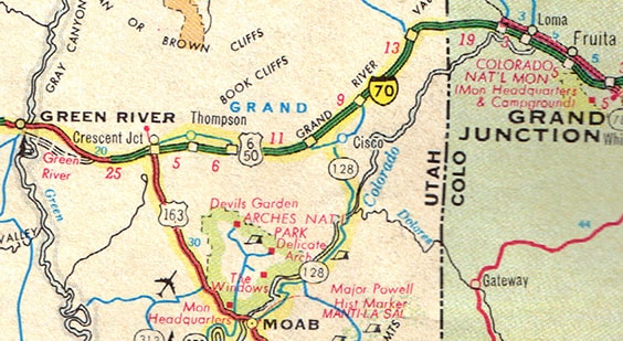
First of all, it is necessary to understand that US 50 did not originally follow the same route as I-70 through Crescent Junction:
Picture
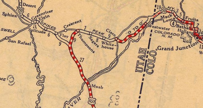
c. 1927, Rand McNally
Picture
c. 1929, UDoT
Notice how there was a fairly pronounced jog in US 50 west of "Thompsons" (now known as Thompson Springs), going through Valley City, the site of a land development project named for its promoters (the Valley City Company in Indianapolis).  At the time, Valley City was situated at a pretty important location, marking the junction of east-west US 50 and north-south US 450.  The site is about five miles south of Crescent Jct (I-70 exit 180); this interactive image is looking north on US 191:
Off to the left was the original route of US 50, heading west towards Green River.  Eastbound US 50 was ahead along 191 for about a half-mile, but then it veered to the right along another gravel road that leads directly to Thompson.  So US 450 followed today's US 191 up to that point, ending there at its junction with US 50.
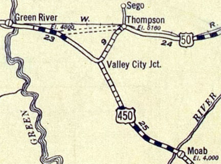
Even after US 50 was moved to its more direct alignment between Thompson and Green River (essentially the same route used by I-70 today), it appears there was a brief period before the road to Crescent Jct. was built, and US 450 may have had a forked terminus north of Valley City:
Picture
c. 1933, Gousha for UDoT

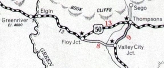
It was about 1934 when the new US 450 was opened to traffic between Valley City and Crescent Jct:
Picture
c. 1934, Gousha/Conoco
There, US 50 was shown along the new route (although the old route through Valley City was still shown as well), and the junction with US 450 had been relocated to Crescent Jct.  That realignment in itself probably would have been enough to eventually wipe Valley City off the map... but things got even worse.  Some maps still show a "Valley City Reservoir" nearby, but actually that has not existed for decades -- repeated flooding caused the dam to fail, and the entire settlement was abandoned in the late 1930s (by 1938 the US 450 designation had been replaced by an extension of US 160):
Picture
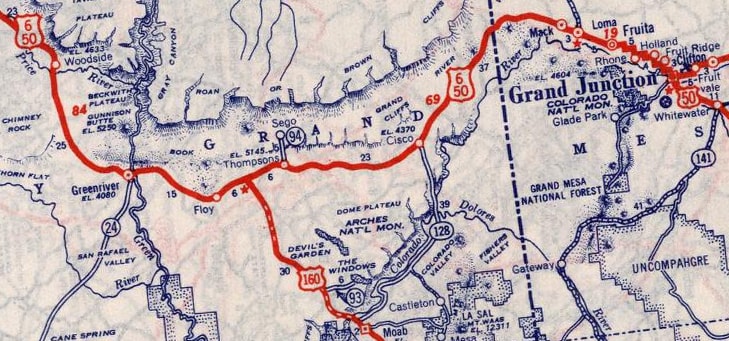
c. 1939, Rand McNally
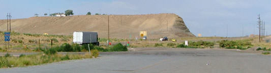
Not that Valley City's future was ever very promising: Crescent Jct (the modern functional equivalent of Valley City) appears to consist of only two structures.  Basically the entire settlement is visible on the left side of this photo, which was taken from eastbound I-70:
Picture
Shafer, Nov. 2003
Beyond the town, the setting sun is illuminating the Book Cliffs, which run from Helper UT to Palisade CO, marking the abrupt southern edge of the Tavaputs Plateau.  Here are some views taken from the opposite direction:
Picture
Sanderson, July 2004
Picture
Summa
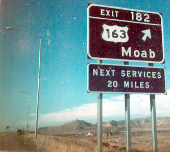
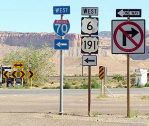
Incidentally, those photos also illustrate how UDoT renumbered their interchanges at some point.  That last shot was back when this highway was signposted as US 163 (US 191 signs replaced the US 163 signs a few years after that photo was taken):
Picture
c. 1977, Rand McNally
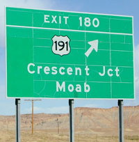
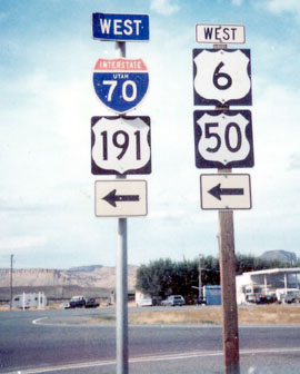
Here is modern signage on northbound US 191 approaching Crescent Jct:
Picture
Shafer, Nov. 2003
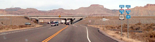
Note that although US 6 and US 50 are routed along I-70 both directions from there, neither route is mentioned on that signage.  But since old highway 6-50 ran along what is now the frontage road on the opposite (north) side of I-70, we will continue ahead, to just beyond the freeway overpass:
Picture
Summa
Picture
Sanderson, July 2004
In the foreground is the offramp from westbound.  US 191 continues north from here by turning left to join westbound I-70, but the spot where this road actually ends (at the yellow signs just beyond the access ramps) is historic US 6-50.  So that intersection marks the historic west terminus of US 450 and US 160, as well as the original north end of US 163.  To the west (left), the alignment of old US 6-50 is now vacated; this photo was looking that direction:
Picture
Sanderson, July 2004
Originally US 50 (and later US 6) continued straight ahead, and at various times three US routes began to the left (south).  Today, west from there, the old route becomes impassable where the interstate assumes its right-of-way (the white semi is on the onramp to westbound I-70).  But to the east from Crescent, US 6-50 ran along what is now a frontage road for I-70 (CR 175) through Thompson Springs (off exit 185) to exit 202.  East of there the old highway is on the south side of I-70, going through Cisco to exit 212.  There it effectively disappears underneath I-70 again until around exit 225, where it re-emerges on the north side again and crosses into Colorado.  Much of the old road is still drivable, but as one might expect it is in increasingly rough shape.  In 1983, the US 191 designation was extended through this area.  Signage for US 163 was removed, although UDoT has never officially changed the north endpoint of that route.  So one could argue that US 163 still ends in Crescent, although according to posted signage, no routes currently terminate there.
main US 160 page
main US 163 page
main US 450 page
Research and/or photo credits: Steve Lockwood; Dale Sanderson; David Shafer; Thomas Silas; Michael Summa
Page originally created 2003;
last updated Apr. 18, 2021.
Copyright © 1998-2023
Picture