Historic endpoints of US 31 in Mobile, AL
Battleship Parkway is the original 1926 causeway across Mobile Bay (prior to that, automobile traffic had to use ferries between Mobile and Daphne and/or Fairhope). Historic maps published by various governments and commercial cartographers alike agree that US 31 did not always end at Spanish Fort; rather, the designation extended west, overlapped with US 90. And the earliest US highway route logs specify US 31's endpoint as "Mobile" (not Spanish Fort). But where precisely did US 31 terminate?
The only endpoint I have been able to confirm is that US 31 ended on Government Street at its junction with Broad Street. This appears to have been true for at least three decades (1950s-1970s), and it was possibly the case as early as 1927 and as late as about 1980 (which is when I suspect US 31 was truncated to Spanish Fort). Another Mobile page has photos and more information about historic endpoints at the Government/Broad intersection.
For further details about US 31 in Mobile, keep reading. This page contains all the info I have been able to find so far, but unfortunately there are still more questions than answers. Sources include:
- Alabama official state highway maps (most of which I simply describe, although a few are shown below)
- Other Alabama Dept. of Transportation maps (formerly Alabama Highway Dept, but all are cited as ALDoT on this page)
- USGS topo maps (various dates and scales). Descriptions are provided for the sake of completeness, but I have seen several USGS maps on which the highway designations were simply wrong, and I suspect that was the case with most of the Mobile quads, unfortunately.
- Commercial maps
|
I am interested in seeing any additional information that might shed light on the route of US 31 in Mobile:
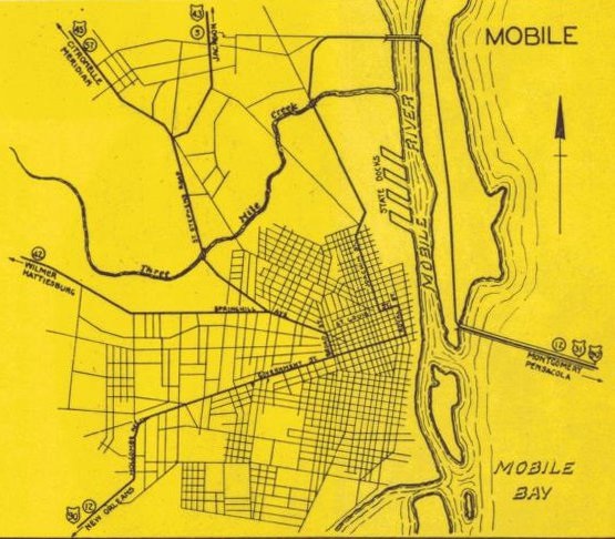
The US routes were signed in the late 1920s, but the earliest Mobile inset I have seen was on a 1929 Gousha map: |
|
Along the right-hand edge, that showed US 31 and US 90 twinned on the mis-labeled Cochrane Bridge, which was actually Battleship Pkwy. There were no additional US 31 markers on the map, but the thick highway line continued by heading north on Blakeley Island, and then crossed the Mobile River via the actual Cochrane Bridge (which opened in 1927, in the same location as today's Cochrane-Africatown Bridge). After heading west a bit on Bay Bridge Road, it then turned south on Telegraph Road and crossed the railyards to merge with Conception Street (today that movement is no longer possible, as Conception has been vacated where Beauregard Street cuts through). That map is certainly not conclusive, but one could make a reasonable guess that US 31 ended on Conception at its intersection with Government Street, one block from the courthouse.
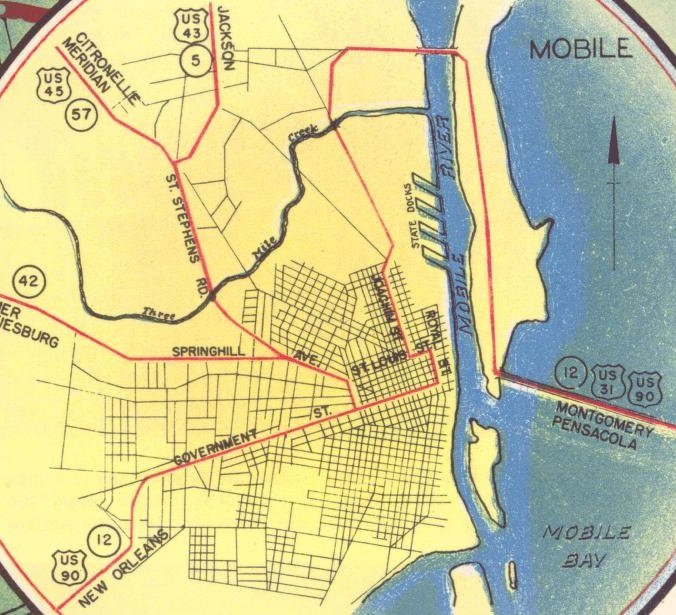
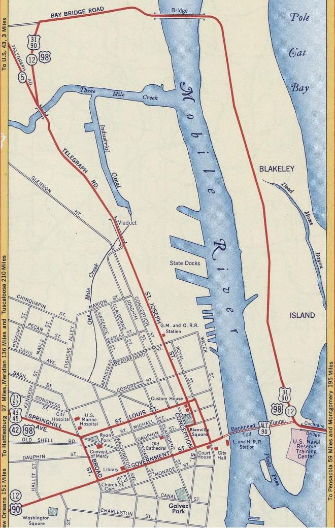
The earliest official state highway map inset I have seen is from 1936, and it showed things a little differently: |
|
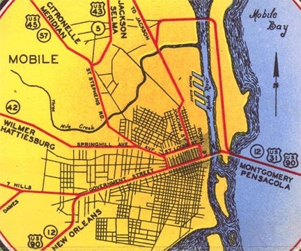
That was still a few years before the Bankhead Tunnel opened. The routing of US 90 is clearly shown, and much of it matches the Gousha map above: after crossing Mobile Bay, it continued by heading north on Blakeley Island, then crossed the Mobile River via Cochrane Bridge, then headed west a bit on Bay Bridge Road, and then turned south on Telegraph Road and crossed the railyards. However, the connection was no longer with Conception Street, but rather with Joachim Street. Then east three blocks on St. Louis Street, south on Royal Street, west on Government, and out of town. The 1939 edition of the map showed this more clearly, using red strokes for highway routes:
|
Note how route designations were marked only on the map margins. That practice makes it more difficult to determine intra-city routings, and unfortunately ALDoT did that all the way through their 1970 edition.
|
On the right side of all three maps, it can be seen that US 31 came across Mobile Bay with US 90, and while the route obviously ended somewhere in Mobile, it is not clear exactly where. Looking at the two ALDoT maps, my best guess would be that US 31 ended on Royal at Government, because the courthouse was at that intersection, and in the early days it was common for highway designations to terminate at important government buildings. It is also possible that US 31 was signed with US 90 up Government all the way to Broad, such that US 31, 43, and 45 all shared a common terminus. To me it seems kind of pointless to have signed US 31 anywhere past downtown. However, as we will see below, that was in fact its endpoint during the 1950s, so maybe that arrangement was established as early as the '30s. And finally, another possible endpoint would have been the causeway landing on Blakeley Island, only because it would have been a little confusing for southbound US 31 to continue by turning north for three miles. But on the other hand, it seems pointless to overlap US 31 with US 90 that far, only to have it end without actually reaching Mobile.
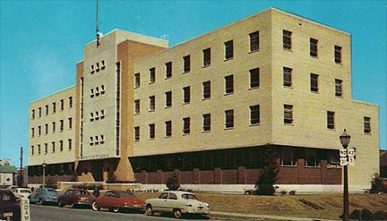
1940 1:32k USGS topo: the routing indicated on the above maps was shown in greater detail here. The Bankhead Tunnel was already shown on this map (presumably because, even though it didn't open until 1941, construction began in 1938). The last US 31 marker was placed at the east tunnel entrance (from here on I will refer to this location as BIJ, for "Blakeley Island Junction"). However, I am skeptical that US 31 would've ended at BIJ. The Tunnel was new at the time, so I lean towards the notion that officials simply had not yet decided how it would affect highway routes. Backing up this theory is the fact that no US 90 shields were placed anywhere between BIJ and Broad, either. This next image is a detail from a photograph that showed the Bankhead Tunnel in the background, so obviously it was taken in 1941 or later. The perspective was looking eastbound on Government, and in the foreground was a sign assembly directing US 90 and US 31 traffic north on Conception: |
|
So that brings us back to the first map above, the 1929 Gousha that suggested US 90 and US 31 used Conception. However, the 1941 ALDoT map did not corroborate that at all. This was the first ALDoT map to show the Bankhead Tunnel, which shaved about seven miles off the old Cochrane Bridge - Telegraph route. However, there was a toll to use the Tunnel, and sometimes the Tunnel had to be closed (for example, during storm surges). So the old route was also kept open. Based on other maps (described below), this is probably when the "Alternate US 90" designation was created along one of the routes, while mainline US 90 used the other. However, this map does not specify which designation used which route, nor which route US 31 traffic was directed to use. There were a number of potential endpoints:
|
Complicating the issue even further is the fact that this was the first map to use red strokes for some major roads that were not highway routes, and the first map to show St. Louis between Joachim and Broad with a red line (no change on the 1942 or 1946 editions.) So did that mean St. Louis was a highway, or just a major road? The next entry may provide a clue:
1943 1:32k USGS: this showed a new viaduct over the railyards that brought Telegraph traffic straight onto St. Joseph Street (rather than Joachim). This map also indicated that US 90 no longer used Royal to get to Government. Instead, it went west on St. Louis, and then south on Broad to Government. Royal was still a red line, so it could have been US 31, but the last US 31 marker was placed at BIJ. There were two US 90 markers between there and downtown Mobile, but neither of them were accompanied by US 31 markers, suggesting that US 31 ended at BIJ. But see the next year:
1944 1:62k USGS: this indicated that US 31 went north from BIJ (with US 90) at least as far as the Cochrane Bridge, but how far past there is unclear. This was the first map to clearly indicate that the Bankhead Tunnel was designated Alt. 90.
1946 ALDoT: last map to show Royal with a red stroke.
1949 ALDoT: first map to indicate the new viaduct over the railyards that brought Telegraph traffic straight onto St. Joseph. However, Royal is no longer shown as a route. Instead, all highway traffic is shown heading west on St. Louis, then south on Broad to Government (no change on the 1954 edition). But it remained unclear which route US 31 and US 90 traffic was directed to follow. This next map is the earliest one I have seen that answers that question:
|
1952 ALDoT, Mobile County:
|
There, US 31-90 is shown to use the Tunnel, while the Cochrane-Telegraph route is shown only as SH 12. This map leaves little room for doubt that US 31 ended at its intersection with Broad, and therefore it shared a common terminus with US 43 and 45. Can this map be considered reliable? Well, there is the following photo, probably taken around 1950:
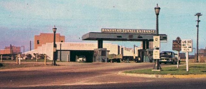
That was taken at BIJ, looking towards the Tunnel's east entrance. The sign at right said "US 90 Toll (left arrow); Free Route (right arrow)" (referring to the Cochrane-Telegraph route). So, while that does nothing to answer the US 31 question, it does verify that US 90 traffic was indeed directed to use the Tunnel (as opposed to what contemporary USGS maps indicated). So it is certainly conceivable that US 31 also used the Tunnel, as illustrated on the preceding map.
|
1953 1:24k USGS: this map indicated that it was Alt. US 90 that went through the Tunnel, while mainline US 90 (and US 31) went north from BIJ, across the Cochrane Bridge, and south on Telegraph/St. Joseph. US 43 was also marked along Telegraph, instead of its original route (see also next entry). From St. Joseph, only US 90 was shown heading west on St. Louis, but not US 31 or US 43. Royal was not shown in red, so this map suggests that both US 31 and 43 could have ended at the Federal Courthouse (where US 90 turned from St. Joseph onto St. Louis). The 1955 and 1959 revisions of the 1:62k topo suggest the same.
|
The image on this postcard, probably from the 1950s, was looking north from Adams Street along St. Joseph. It showed the Seamen's Club Hotel, which was later used by the City of Mobile, but is apparently abandoned now. At far right was a shield assembly which confirms that US 31-43-90 traffic used St. Joseph at that time:
|
|
1955 ALDoT: first map since 1939 to use red strokes only for highway routes (not for other major roads), as well as the first map to show US 98 signed through Mobile. Also, this was the first to show a US 43 shield on Telegraph, in addition to its original route along Wilson - St. Stephens - Spring Hill. This reflects the fact that Telegraph was changed to mainline 43, while the original route was re-designated as Alt. US 43.
|
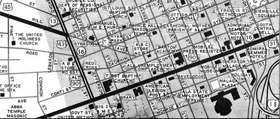
1956 Gousha: Based on other maps in this series, red lines seem to have been used only for numbered highway routes... so why were Royal and Conception shown with red strokes? One possible interpretation is that US 98 followed St. Joseph - St. Louis - Spring Hill; US 90 followed St. Joseph - Dauphin - Conception - Government; and US 31 followed St. Joseph - St. Louis - Royal. This is the most detailed historic map of Mobile I have seen:
|
1957 ALDoT: first map to differentiate US routes (red strokes) from state highways (blue strokes). No change on the '58, '59, '61 editions.
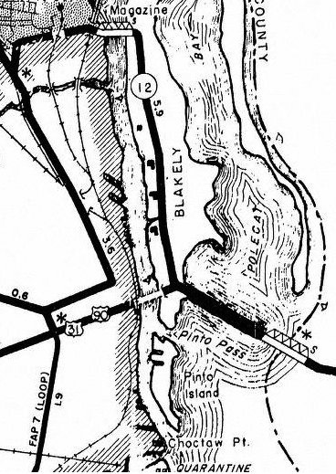
1962 ALDoT: first map to show highway traffic (presumably US 43 and Alt. US 90) had been directed to use Beauregard Street (rather than St. Louis) to Broad. 1963 ALDoT: first map to show interstates 10 and 65 under construction (and of course subsequent editions show these in increasing states of completion, until the 1979 map). 1964 ALDoT: last map to show US route(s) crossing the Cochrane Bridge. 1965 ALDoT: first map to show all US routes (at least US 90-98) using the Bankhead Tunnel (instead of the Cochrane Bridge). It is not clear whether US 31 ended at BIJ, or whether it used the Tunnel too, in which case the only possible endpoint would have been on Government at Broad. (No change on the '67 edition.) 1967 1:24k USGS: showed the same routes as the 1953 edition, which is odd, since apparently by 1962 highway traffic was using Beauregard instead of St. Louis. Therefore this map is probably unreliable with regard to highway routes. 1970 ALDoT: last map to show a US 31 shield on the Mobile inset. 1972 ALDoT: first map to lack any indication that US 31 entered Mobile. In similar cases it could be considered significant that there were no US 31 markers, because it would imply that the route could not have gone any farther west than BIJ. On the other hand, it could simply be attributed to the fact that the scope and style of the map changed... and, based on the 1977 map shown below, I lean toward that explanation. |
1974 1:24k USGS: showed the same routes as the '53 and '64 editions, which is odd, since apparently by 1962 highway traffic was using Beauregard instead of St. Louis. Therefore this map is probably unreliable with regard to highway routes, particularly when one considers this next entry:
1979 ALDoT: first map to show I-10 complete across Mobile Bay. I suspect this is about when US 31 was truncated to its current terminus at Spanish Fort. Reason: there were now two causeways across Mobile Bay, so why make things more confusing than necessary by signing them with four different highway designations? Better to eliminate the redundant designation (US 31).
1981 ALDoT: first map since '64 to show a US route using the Cochrane Bridge (Alt US 90).
1982 1:24k USGS: Alt. US 90 was the only US route shown using the Cochrane Bridge. This map finally showed the highway routing along Beauregard (instead of St. Louis), but it carried only US 43 (not US 31). In fact, there were no US 31 shields at all on the Mobile quad, but on the adjacent quad to the east there was a US 31 marker on the Causeway, implying that it didn't go any farther than BIJ.
Research and/or photo credits: Charles; Nathan Edgars; Mike Roberson; Dale Sanderson
Page originally created 2016;
last updated Jul. 8, 2024.
last updated Jul. 8, 2024.

