US Ends .com
  • Home
  • Store
    • US highway map
    • Florida US highway map
  • Endpoints
    • US 1 - US 9 >
      • 1 >
        • 201
        • 301
        • 401 [i]
        • 401 [ii]
        • 401
        • 501
        • 601
        • 701
      • 2w >
        • 102
      • 2e >
        • 202
        • 302
      • 3
      • 4 >
        • 104
      • 5
      • 6 >
        • 106
        • 206
      • 7
      • 8
      • 9 >
        • 109*
        • 209
        • 309
    • US 10 - US 19 >
      • 10 >
        • 110
        • 210
        • 310
        • 410
      • 11 >
        • 111
        • 211
        • 311
        • 411 [i]
        • 411 [ii]
        • 411
        • 511*
        • 611
        • 711*
      • 12 >
        • 112
        • 212
        • 312
      • 13 >
        • 113
        • 213
      • 14
      • 15
      • 16 >
        • 116
        • 216
      • 17 >
        • 17-1
        • 117 [i]
        • 117
        • 217
      • 18 >
        • 118
        • 218
      • 19 >
        • 119
        • 219
        • 319
    • US 20 - US 29 >
      • 20e >
        • 120
        • 220
        • 320
        • 420
      • 20w
      • 21 >
        • 121 [i]
        • 121
        • 221
        • 321
        • 421
        • 521
      • 22 >
        • 122 [i]
        • 122 [ii]
        • 222
        • 322
        • 422e
        • 422w
        • 522
        • 622*
      • 23 >
        • 123 [i]
        • 123
        • 223
      • 24 >
        • 124
        • 224
      • 25
      • 26 >
        • 126
      • 27 >
        • 127
        • 227
      • 28
      • 29 >
        • 129
    • US 30 - US 39 >
      • 30 >
        • 130
        • 230
        • 330
        • 430
        • 530
        • 630*
        • 730
        • 830
      • 31 >
        • 131
        • 231
        • 331 [i]
        • 331
        • 431
      • 32
      • 33
      • 34
      • 35
      • 36 >
        • 136
      • 38 >
        • 138
    • US 40 - US 49 >
      • 40 >
        • 140
        • 240
        • 340
      • 41 >
        • 141
        • 241 [i]
        • 241 [ii]
        • 341
        • 441 >
          • 441n
          • 441s
        • 541
        • 641
      • 42
      • 43
      • 44
      • 45
      • 46
      • 48 [i]
      • 48 [ii]
      • 48
      • 49
    • US 50 - US 59 >
      • 50 >
        • 150
        • 250
        • 350
        • 450
        • 550
        • 650
      • 51 - 55 >
        • 51 >
          • 151
        • 52 >
          • 152
        • 53
        • 54 >
          • 154
        • 55
      • 56 >
        • 156
      • 57
      • 58 >
        • 158
        • 258
      • 59 >
        • 159
        • 259
    • US 60 - US 69 >
      • 60 >
        • 160
        • 260
        • 360
        • 460
      • 61 - 65 >
        • 61 >
          • 161
        • 62
        • 63 >
          • 163 [i]
        • 64 >
          • 164 [i]
          • 164 [ii]
          • 264
        • 65 >
          • 165
      • 66 >
        • 166
        • 266
        • 366 [i]
        • 366 [ii]
        • 466
        • 566
        • 666
      • 67 >
        • 167
      • 68 >
        • 168
      • 69 >
        • 169
    • US 70 - US 79 >
      • 70 >
        • 170
        • 270 [i]*
        • 270
        • 370
        • 470
      • 71 >
        • 171
        • 271
        • 371 [i]
        • 371
      • 72 - 76 >
        • 72
        • 73
        • 74
        • 75 >
          • 175
          • 275
        • 76 >
          • 176
          • 276
      • 77 >
        • 177
        • 277
        • 377
      • 78 >
        • 178
        • 278
        • 378
      • 79
    • US 80 - US 89 >
      • 80 - 84 >
        • 80 >
          • 180 [i]
          • 180
          • 280
          • 380
        • 81 >
          • 181
          • 281
        • 82
        • 83 >
          • 183
          • 283
          • 383
        • 84
      • 85 - 89 >
        • 85 >
          • 185
          • 285 [i]
          • 285
          • 385 [i]
          • 385
          • 485
        • 87 >
          • 187
          • 287n
          • 287s
        • 89n
        • 89s >
          • 189 [i]
          • 189
    • US 90 - US 99 >
      • 90 - 94 >
        • 90 >
          • 190
          • 290
        • 91 >
          • 191 >
            • 191n
            • 191s
          • 491
        • 92 >
          • 192
        • 93
        • 94
      • 95 -98 >
        • 95 >
          • 195
          • 295
          • 395
        • 96 [i]
        • 96
        • 97 >
          • 197
        • 98
      • 99 >
        • 199
        • 299
        • 399
    • Anomalies >
      • 101
      • 163
      • 400
      • 412
      • 425
  • Places
    • A-L >
      • A >
        • Aberdeen
        • Albuquerque
        • Amarillo
        • Apalachicola
        • Astoria
        • Atlantic
      • B >
        • Baltimore
        • Baton Rouge
        • Bay Area
        • Bishop
        • Boone
        • Brady
        • Bristol
        • Brownsville
        • Brunswick
      • C >
        • Charleston
        • Chattanooga
        • Chicago
        • Cincinnati
        • Cleveland
        • Cody
        • Corpus
        • Cortez
        • Council Bluffs
        • Covington
        • Crescent
        • Cumberland Gap
      • D-E >
        • Dallas
        • Des Moines
        • Detroit
        • Dothan
        • Douglas
        • El Paso
        • Eugene
        • Erie
      • F >
        • Farmington
        • Flagstaff
        • Florence
        • Fox Valley
        • Franklin
      • G >
        • Gallup
        • Grand Junction
        • Grand Portage
        • Grayling
        • Great Falls
        • Greeley
      • H-I >
        • Hardeeville
        • Harrisburg
        • Holbrook
        • Idaho Falls
        • Int'l Falls
      • J-K >
        • Jacksonville
        • Joplin
        • Junction
        • Kansas City
        • Keokuk
        • Key West
        • Kingman
      • L >
        • Laredo
        • Lewiston
        • Long Beach
        • Los Angeles
        • Louisville
        • Lubbock
    • M-R >
      • M >
        • Mackinaw
        • Madison
        • Maryhill
        • Maysville
        • Miami
        • Midway
        • Miles City
        • Milford
        • Milwaukee
        • Minneapolis
        • Mobile 31
        • Mobile 31-43-45
        • Montgomery
        • Monticello
        • Mount Vernon
      • N-O >
        • Nags Head
        • Naples
        • Natchez
        • New Castle
        • New Orleans
        • Niagara
        • Norlina
        • Ocean City
        • Oklahoma City
      • P >
        • Pee Dee
        • Pembina
        • Pensacola
        • Petersburg
        • Philadelphia
        • Piegan
        • Pineville
        • Port Arthur
        • Portsmouth
      • Q-R >
        • Quad Cities
        • Rapid City
        • Raton
        • Reading
        • Richmond
        • Rockingham
        • Rouses Point
    • S-Z >
      • S >
        • San Antonio
        • San Antonio NM
        • San Diego
        • Santa Fe
        • Savannah
        • Sioux
        • Springer
        • Springfield
        • St. Ignace
        • St. John
        • St. Paul
        • St. Pete
      • T-U-V >
        • Tallahassee
        • Tampa
        • Toledo
        • Trinidad
        • Ucolo
        • VA Beach
      • W >
        • Walterboro
        • Waverly
        • West Memphis
        • Wilmington
        • Wilson
        • Wrightsville
      • Y >
        • Yellowstone E
        • Yellowstone N
        • Yellowstone NE
        • Yellowstone S
        • Yellowstone W
  • Highways
    • Map of all endpoints
    • Sources
    • History
    • 1926 almost-routes
    • Intra-state routes
    • Numbering
    • Colors
    • Gaps
    • Blog
  • Bonus
    • Colorado >
      • Lowest point
      • Antipodes
      • Toponymy >
        • Roots
      • Colloquialisms
      • Populations
      • Denvers
    • Washington Meridian
    • Watersheds >
      • Headwaters Hill
      • Three Waters Mtn.
      • Parting of the Waters
    • Geo-centers >
      • 48 states
      • 50 states
      • North America
    • State corners >
      • AZ-CO-NM-UT
      • CO-UT-WY
      • CO-NE-WY
      • CO northeast
      • CO-KS-NE
      • CO-KS-OK
      • CO-NM-OK
      • NM-OK-TX
      • NM southeast
      • TX northwest
    • ooss.space
  • Connect
    • Author/history
    • Rationale
    • Contact
    • Contributors
    • Submissions

US 36

End of US highway 36

View a map showing this route.
Get your very own map showing all current and historic US routes!
Picture
Summa
Picture
Summa
1926-1929
  • East: Indianapolis, IN
  • West: Colby, KS
1929-1931
  • East: Indianapolis, IN
  • West: Byers, CO
1931-1933
  • East: Cadiz, OH
  • West: Byers, CO
1933-1937
  • East: Cadiz, OH
  • West: Strasburg, CO
1937-1967
  • East: Cadiz, OH
  • West: Denver, CO
1967-1974
  • East: Cadiz, OH
  • West: Estes Park, CO
1974-1977
  • East: Uhrichsville, OH
  • West: Estes Park, CO
1977-present
  • East: Uhrichsville, OH
  • West: Deer Ridge Jct, CO
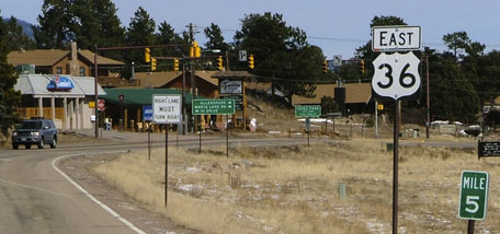
Mileage: in 1989 AASHTO listed a figure of 1431 miles for US 36... however, that included the mileage of US 36's associated business routes.  According to the state subtotals on AASHTO's 1989 spreadsheet, mainline US 36's actual end-to-end total at the time was 1414 miles.  Our own 2020 measurement yielded 1402.8 miles (reroutings and realignments likely explain the difference).  ​
The closest town to US 36's midpoint is Wheeling, Missouri.

When the US routes were originally commissioned in late 1926, the east end of US 36 was in Indianapolis.  It came in via Rockville Road, junctioning US 40 at Washington Street:
Picture
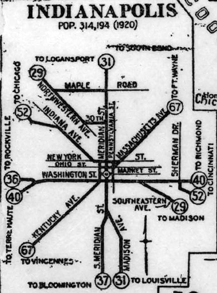
c. 1928, State Highway Commission of Indiana
US 36 could have ended at that intersection, but it is more likely that it overlapped with US 40 into the city, ending at its junction with the main north-south highway, US 31.  This intersection would have been at Meridian Street.  This image was looking west along Washington:
Picture
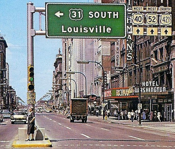
c. late 1950s, attribution unknown

Historically that was westbound US 40-52.  At the time of that photo, southbound US 31 traffic was directed to use Pennsylvania Street to the left.  But thirty years earlier, when US 36 ended in the city, US 31 used Meridian Street, which is the next block ahead, so that intersection was probably the east beginning of US 36.  

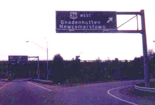
But already by 1931, US 36 had been extended east to Cadiz:
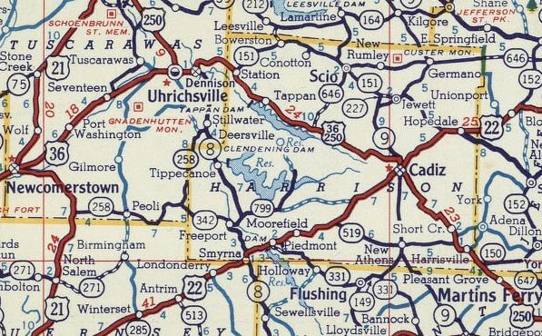
Picture
c. 1956, Gousha
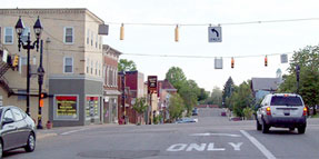
Traffic came in on Dennison Avenue, which merges with Lincoln Avenue in town, which in turn becomes Market Street near downtown.  So at first, US 36 ended at Main Street, which carried US 22.  This photo was taken looking southeast on Market:
Picture
Nelson, May 2008
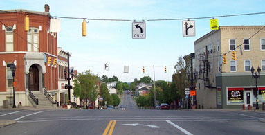
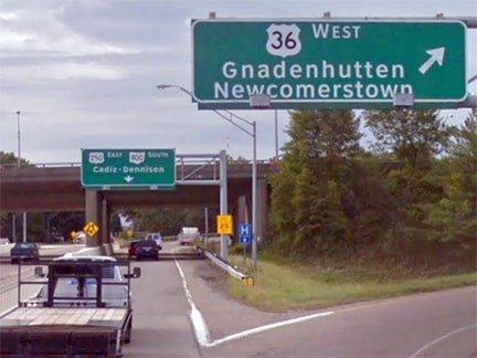
Today Market carries US 250.  The crossroad is Main, or historic US 22, so US 36 ended there.  This photo was looking northeast on Main:
Picture
Nelson, May 2008
That was eastbound US 22, and US 36 began to the left on Market.  In 1961, today's US 22 bypass was built around the north edge of town.  When that happened, it is possible that the US 36 designation was truncated to its junction with the new US 22.  This photo was taken from westbound US 22-250:
Picture
Nelson, May 2008
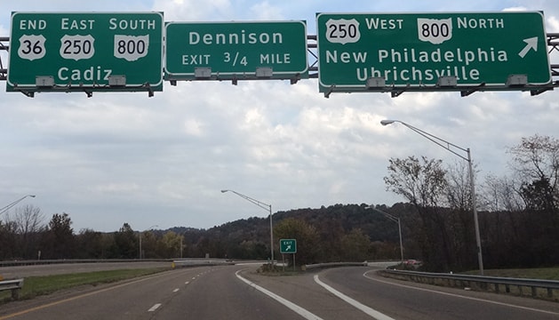
There, US 250 splits off by exiting to the right.  That could have been the east beginning of US 36 for a time.  However, after the US 22 bypass was built, Main was probably signed as Business 22, so it is also possible that US 36 continued to end at its original downtown location.  ​Then, in 1974...
Picture
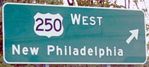
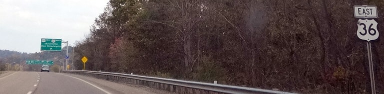
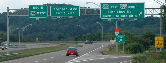
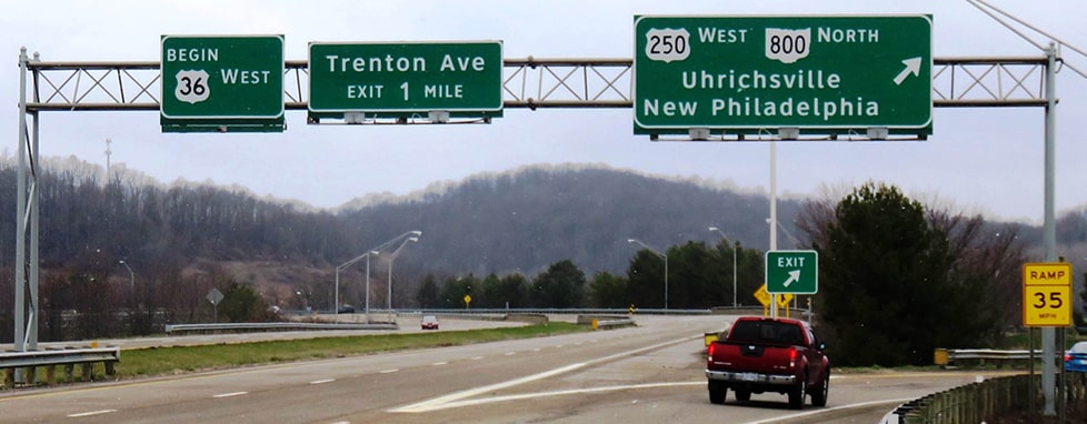
...US 36's multiplex with US 250 was eliminated by truncating the east end to its current terminus in Uhrichsville (the image above is from the AASHTO meeting minutes where that action was approved).  These shots show the east beginning of US 36 from the perspective of drivers heading south on eastbound US 250:
Picture
Reighard, Sep. 2002
Picture
Google Maps Street View, Sep. 2018
This photo shows the last eastbound US 36 shield:
Picture
Stuve, Oct. 2016
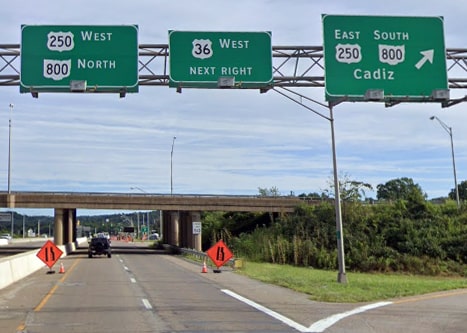
The green signs visible in the distance mark the east terminus of US 36, shown close-up in these photos:
Picture
Reighard, Sep. 2002
Picture
Stuve, Oct. 2016
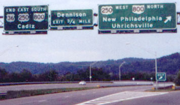
​Note the "End" sign at far left.  These photos were taken from the opposite direction:
Picture
Mortell, Aug. 2006
That was on westbound US 250 / northbound OH 800, both of which exit to the right.  Straight ahead is the east beginning of US 36.  Those Highway Gothic panels were later replaced with Clearview versions:
Picture
Ferguson, Apr. 2018
And finally, one more perspective.  This image was taken looking north on Water Street, or historic westbound US 250.  From here, the east beginning of US 36 is signed thus:
Picture
Google Maps Street View, Aug. 2019

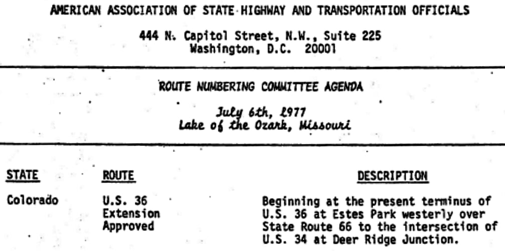
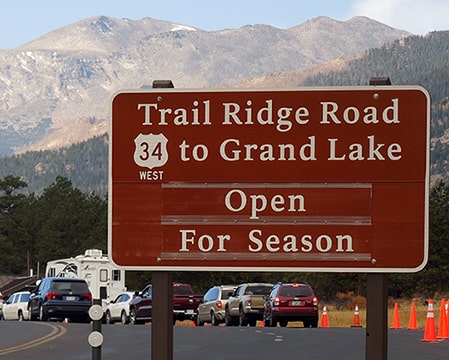
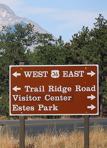
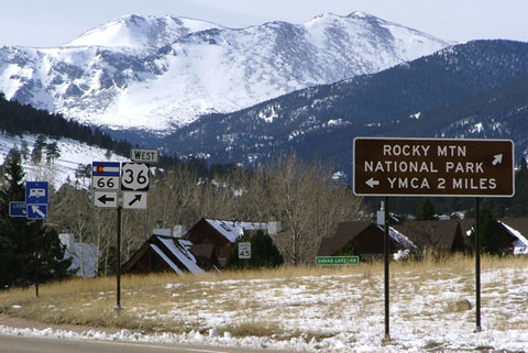
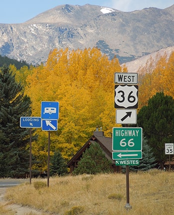
The original west terminus of US 36 was in Colby, but the designation was extended incrementally westward over the years, first to Byers, then Strasburg, Denver, and Estes Park.  More info and photos from each of those places can be found on the historic US 36 page.  In 1968, shortly after US 36 had been extended to Estes, Colorado sought permission from AASHO to further extend the designation along former CO hwy. 66, to its current terminus in Rocky Mountain National Park.  The initial request was not approved (apparently because AASHO was under the impression that it was National Park Service policy to not have US routes running within their properties), but then Colorado provided the following explanation, and the request was granted later in 1977:
Picture
Picture
Thirty years later there was no "End" sign, but these photos show the signage that has been posted at the west end:
Picture
Sanderson, Feb. 2005
Picture
Sanderson, Jun. 2011 (unchanged as of 2022)
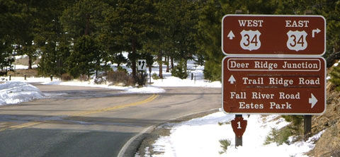
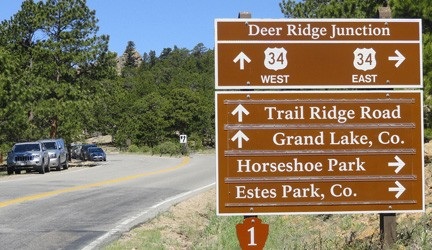
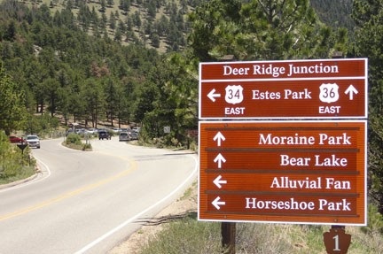
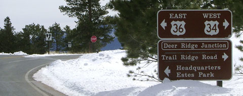
In the background is the "T" intersection where 36 ends (known as "Deer Ridge Junction").  If a traveler goes straight, they are heading west on US 34, over Trail Ridge Road towards Grand Lake.  If one turns right, they will wind around and head east on US 34, back to Estes.  Heading that direction (east on US 34, down from Trail Ridge), drivers would see this signage where US 34 continues to the left, while straight ahead is the west beginning of US 36:
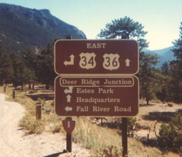
Picture
Summa, after 1978
Picture
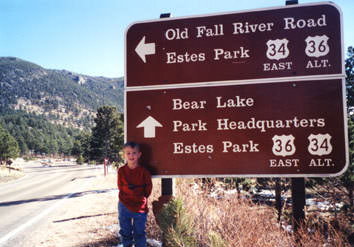
Sanderson, 1999 (still there in 2005)
Picture
Sanderson, Jun. 2011 (unchanged as of 2020)
US routes are not signed in Yellowstone National Park (which is of particular interest to roadfans, because it means that highways which enter the Park from two directions [such as US 20] technically have interruptions in their mileage).  However, as these photos attest, not all National Parks follow that practice.  NPS signs both US 34 and US 36 within RMNP, and not only at Deer Ridge Jct:
Picture
Sanderson, Oct. 2020 (wb US 36 at Beaver Meadows Entrance)
Picture
Sanderson, Oct. 2020 (nb Bear Lake Rd at jct. US 36)

Additionally, the 1999 sign pictured above demonstrates how the Park Service did not have any qualms about signing US routes within their boundaries however they pleased: note how each route was formerly signed as an alternate for the other (since they join again in Estes).  

​
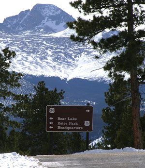
As drivers approach Deer Ridge Jct. on US 34 westbound from Estes, they see this sign...
Picture
Sanderson, Feb. 2005

...and just around the curve at the stop sign, a fantastic view of Longs Peak appears straight ahead (one of Colorado's more well-known 14-ers):
Picture
Sanderson, Feb. 2005
​Note how the destination for westbound US 34 (to the right) was not shown: it is covered up during most of the year, when the road is closed.  This photo shows what that same sign looks like during the warmer months:
Picture
Sanderson, 1999

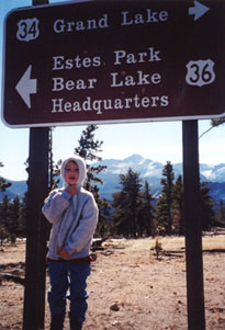
​If a traveler takes a left there, they will not see the first eastbound US 36 confirming marker for another five miles:
Picture
Sanderson, Feb. 2005 (unchanged as of 2020)
​That is on the edge of the Park, almost to Estes city limits, just past where the former SH 66 comes in from the south and merges with US 36.  Directly across the road from there is the last westbound marker, with some excellent scenery in the background:
Picture
Sanderson, Feb. 2005
Picture
Sanderson, Oct. 2020

Research and/or photo credits: Allan Ferguson; Robert Mortell; Steven Nelson; Jason Reighard; Dale Sanderson; Eric Stuve; Michael Summa
Page originally created 2000;
last updated Mar. 6, 2022.
Copyright © 1998-2023
Picture