US Ends .com
  • Home
  • Store
    • US highway map
    • Florida US highway map
  • Endpoints
    • US 1 - US 9 >
      • 1 >
        • 201
        • 301
        • 401 [i]
        • 401 [ii]
        • 401
        • 501
        • 601
        • 701
      • 2w >
        • 102
      • 2e >
        • 202
        • 302
      • 3
      • 4 >
        • 104
      • 5
      • 6 >
        • 106
        • 206
      • 7
      • 8
      • 9 >
        • 109*
        • 209
        • 309
    • US 10 - US 19 >
      • 10 >
        • 110
        • 210
        • 310
        • 410
      • 11 >
        • 111
        • 211
        • 311
        • 411 [i]
        • 411 [ii]
        • 411
        • 511*
        • 611
        • 711*
      • 12 >
        • 112
        • 212
        • 312
      • 13 >
        • 113
        • 213
      • 14
      • 15
      • 16 >
        • 116
        • 216
      • 17 >
        • 17-1
        • 117 [i]
        • 117
        • 217
      • 18 >
        • 118
        • 218
      • 19 >
        • 119
        • 219
        • 319
    • US 20 - US 29 >
      • 20e >
        • 120
        • 220
        • 320
        • 420
      • 20w
      • 21 >
        • 121 [i]
        • 121
        • 221
        • 321
        • 421
        • 521
      • 22 >
        • 122 [i]
        • 122 [ii]
        • 222
        • 322
        • 422e
        • 422w
        • 522
        • 622*
      • 23 >
        • 123 [i]
        • 123
        • 223
      • 24 >
        • 124
        • 224
      • 25
      • 26 >
        • 126
      • 27 >
        • 127
        • 227
      • 28
      • 29 >
        • 129
    • US 30 - US 39 >
      • 30 >
        • 130
        • 230
        • 330
        • 430
        • 530
        • 630*
        • 730
        • 830
      • 31 >
        • 131
        • 231
        • 331 [i]
        • 331
        • 431
      • 32
      • 33
      • 34
      • 35
      • 36 >
        • 136
      • 38 >
        • 138
    • US 40 - US 49 >
      • 40 >
        • 140
        • 240
        • 340
      • 41 >
        • 141
        • 241 [i]
        • 241 [ii]
        • 341
        • 441 >
          • 441n
          • 441s
        • 541
        • 641
      • 42
      • 43
      • 44
      • 45
      • 46
      • 48 [i]
      • 48 [ii]
      • 48
      • 49
    • US 50 - US 59 >
      • 50 >
        • 150
        • 250
        • 350
        • 450
        • 550
        • 650
      • 51 - 55 >
        • 51 >
          • 151
        • 52 >
          • 152
        • 53
        • 54 >
          • 154
        • 55
      • 56 >
        • 156
      • 57
      • 58 >
        • 158
        • 258
      • 59 >
        • 159
        • 259
    • US 60 - US 69 >
      • 60 >
        • 160
        • 260
        • 360
        • 460
      • 61 - 65 >
        • 61 >
          • 161
        • 62
        • 63 >
          • 163 [i]
        • 64 >
          • 164 [i]
          • 164 [ii]
          • 264
        • 65 >
          • 165
      • 66 >
        • 166
        • 266
        • 366 [i]
        • 366 [ii]
        • 466
        • 566
        • 666
      • 67 >
        • 167
      • 68 >
        • 168
      • 69 >
        • 169
    • US 70 - US 79 >
      • 70 >
        • 170
        • 270 [i]*
        • 270
        • 370
        • 470
      • 71 >
        • 171
        • 271
        • 371 [i]
        • 371
      • 72 - 76 >
        • 72
        • 73
        • 74
        • 75 >
          • 175
          • 275
        • 76 >
          • 176
          • 276
      • 77 >
        • 177
        • 277
        • 377
      • 78 >
        • 178
        • 278
        • 378
      • 79
    • US 80 - US 89 >
      • 80 - 84 >
        • 80 >
          • 180 [i]
          • 180
          • 280
          • 380
        • 81 >
          • 181
          • 281
        • 82
        • 83 >
          • 183
          • 283
          • 383
        • 84
      • 85 - 89 >
        • 85 >
          • 185
          • 285 [i]
          • 285
          • 385 [i]
          • 385
          • 485
        • 87 >
          • 187
          • 287n
          • 287s
        • 89n
        • 89s >
          • 189 [i]
          • 189
    • US 90 - US 99 >
      • 90 - 94 >
        • 90 >
          • 190
          • 290
        • 91 >
          • 191 >
            • 191n
            • 191s
          • 491
        • 92 >
          • 192
        • 93
        • 94
      • 95 -98 >
        • 95 >
          • 195
          • 295
          • 395
        • 96 [i]
        • 96
        • 97 >
          • 197
        • 98
      • 99 >
        • 199
        • 299
        • 399
    • Anomalies >
      • 101
      • 163
      • 400
      • 412
      • 425
  • Places
    • A-L >
      • A >
        • Aberdeen
        • Albuquerque
        • Amarillo
        • Apalachicola
        • Astoria
        • Atlantic
      • B >
        • Baltimore
        • Baton Rouge
        • Bay Area
        • Bishop
        • Boone
        • Brady
        • Bristol
        • Brownsville
        • Brunswick
      • C >
        • Charleston
        • Chattanooga
        • Chicago
        • Cincinnati
        • Cleveland
        • Cody
        • Corpus
        • Cortez
        • Council Bluffs
        • Covington
        • Crescent
        • Cumberland Gap
      • D-E >
        • Dallas
        • Des Moines
        • Detroit
        • Dothan
        • Douglas
        • El Paso
        • Eugene
        • Erie
      • F >
        • Farmington
        • Flagstaff
        • Florence
        • Fox Valley
        • Franklin
      • G >
        • Gallup
        • Grand Junction
        • Grand Portage
        • Grayling
        • Great Falls
        • Greeley
      • H-I >
        • Hardeeville
        • Harrisburg
        • Holbrook
        • Idaho Falls
        • Int'l Falls
      • J-K >
        • Jacksonville
        • Joplin
        • Junction
        • Kansas City
        • Keokuk
        • Key West
        • Kingman
      • L >
        • Laredo
        • Lewiston
        • Long Beach
        • Los Angeles
        • Louisville
        • Lubbock
    • M-R >
      • M >
        • Mackinaw
        • Madison
        • Maryhill
        • Maysville
        • Miami
        • Midway
        • Miles City
        • Milford
        • Milwaukee
        • Minneapolis
        • Mobile 31
        • Mobile 31-43-45
        • Montgomery
        • Monticello
        • Mount Vernon
      • N-O >
        • Nags Head
        • Naples
        • Natchez
        • New Castle
        • New Orleans
        • Niagara
        • Norlina
        • Ocean City
        • Oklahoma City
      • P >
        • Pee Dee
        • Pembina
        • Pensacola
        • Petersburg
        • Philadelphia
        • Piegan
        • Pineville
        • Port Arthur
        • Portsmouth
      • Q-R >
        • Quad Cities
        • Rapid City
        • Raton
        • Reading
        • Richmond
        • Rockingham
        • Rouses Point
    • S-Z >
      • S >
        • San Antonio
        • San Antonio NM
        • San Diego
        • Santa Fe
        • Savannah
        • Sioux
        • Springer
        • Springfield
        • St. Ignace
        • St. John
        • St. Paul
        • St. Pete
      • T-U-V >
        • Tallahassee
        • Tampa
        • Toledo
        • Trinidad
        • Ucolo
        • VA Beach
      • W >
        • Walterboro
        • Waverly
        • West Memphis
        • Wilmington
        • Wilson
        • Wrightsville
      • Y >
        • Yellowstone E
        • Yellowstone N
        • Yellowstone NE
        • Yellowstone S
        • Yellowstone W
  • Highways
    • Map of all endpoints
    • Sources
    • History
    • 1926 almost-routes
    • Intra-state routes
    • Numbering
    • Colors
    • Gaps
    • Blog
  • Bonus
    • Colorado >
      • Lowest point
      • Antipodes
      • Toponymy >
        • Roots
      • Colloquialisms
      • Populations
      • Denvers
    • Washington Meridian
    • Watersheds >
      • Headwaters Hill
      • Three Waters Mtn.
      • Parting of the Waters
    • Geo-centers >
      • 48 states
      • 50 states
      • North America
    • State corners >
      • AZ-CO-NM-UT
      • CO-UT-WY
      • CO-NE-WY
      • CO northeast
      • CO-KS-NE
      • CO-KS-OK
      • CO-NM-OK
      • NM-OK-TX
      • NM southeast
      • TX northwest
    • ooss.space
  • Connect
    • Author/history
    • Rationale
    • Contact
    • Contributors
    • Submissions

US 1

End of US highway 1

View a map showing this route.
Get your very own map showing all current and historic US routes!
Picture
Summa
Picture
Summa
Picture
Summa
Picture
Summa
Picture
Summa
1926-1938
  • North: Ft. Kent, ME
  • South: Miami, FL​​
1938-present
  • North: Ft. Kent, ME
  • South: Key West, FL​
Mileage: in 1989 AASHTO listed a figure of 2593 miles for US 1... however, that included the mileage of US 1's associated business/bypass/alternate routes.  According to the state subtotals on AASHTO's 1989 spreadsheet, mainline US 1's actual end-to-end total at the time was 2377 miles.  That closely matches our own 2016 measurement, which yielded 2370 miles (reroutings and realignments likely explain the difference).  That puts the midway point of US 1 in Colonial Heights, VA.

Claims to fame: US 1 is the longest north-south US route.  It passes through 15 states, more than any other US highway.  That has been true even since the early years, when the highway ran only as far south as Miami, ending at the same place where US 94 began.  ​By 1938 the south end of US 1 was extended to its current terminus in Key West.  ​

​The north end of US 1 has been in Fort Kent ever since the routes were originally signed in 1927:
Picture
c. 1927, Rand McNally
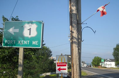
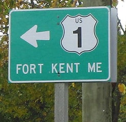
This photo shows one of the last northbound reassurance markers (although drivers are essentially heading south at that point; more on that below):
Picture
Taylor, Oct. 2004
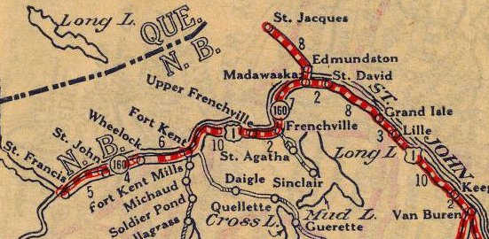
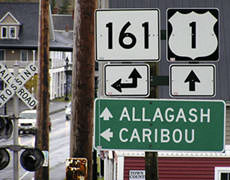
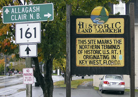
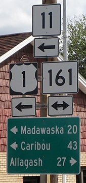
Ahead US 1 overlaps with ME hwy. 161, through the intersection with ME 11, to the bridge that crosses the St. John River to Clair, New Brunswick.  Here the view is southwest on Main Street, approaching the north end of US 1:
Picture
Clements, May 2001
The building in the foreground is the Masonic Lodge, and behind that is US Customs.  Between the two, one can turn right and cross the bridge visible at far right.  Halfway across that span is the international boundary with Canada.  The signs at far right are shown more closely in this photo:
Picture
Taylor, Oct. 2004
ME 161 ahead is about 30 miles long, and goes a bit beyond Allagash before dead-ending.  Unfortunately that historic marker has since been removed, but note it implied that US 1 begins in Key West.  On the other side of that sign, the wording was slightly different:
Picture
Clements, May 2001
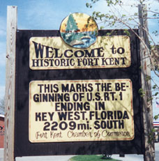
According to that side, Key West marks the end of the route.  I bring this up because it has been reported that some Ft. Kent residents believe they are living "on the top of the world", and they can be quite insistent that US 1 begins there, and ends in Florida.  One can see further evidence of this by taking a few steps closer to the river and checking out a civic monument dedicated to US 1:
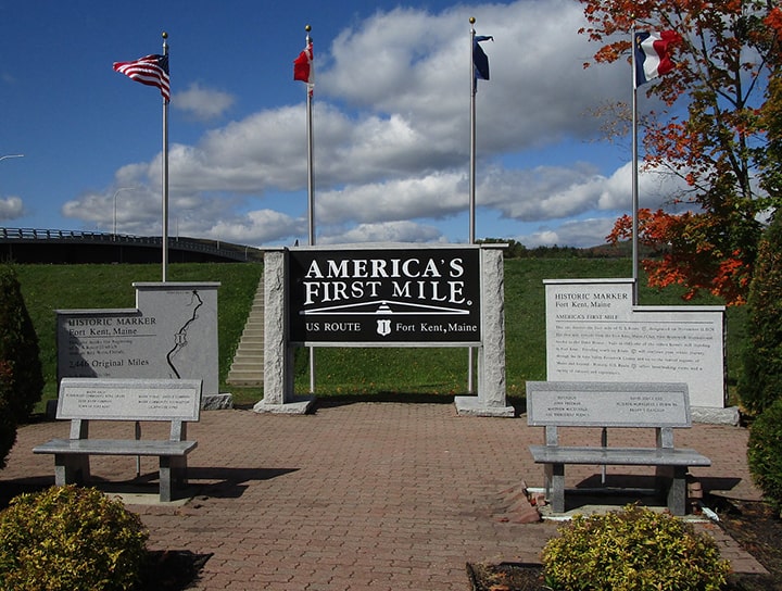
Picture
Dienhart, Sep. 2019
​If you are curious about the text on those side panels, Greg Corkum sent other detailed photos, which you can view here (and on adjacent shots in the photostream).  It is a cool monument, with steps leading up to a nice view of the bridge at far left.  Not many places celebrate a highway terminus to this extent. 

But technically US 1 does not have a beginning or an end; it simply has a north and a south terminus.  In fact, Ft. Kent is not even the northernmost point in Maine.  For that reason, one could argue that US 1 should not be signed all the way to Ft. Kent.  It might make more sense to end the designation at the Madawaska border crossing, which connects with the city of Edmundston NB and a more heavily-used Canadian highway.  From Madawaska, US 1 actually goes south and west to reach Ft. Kent.  So rather than signing that segment as "NORTH US 1", it would probably make more sense to designate it as "SOUTH ME 11".
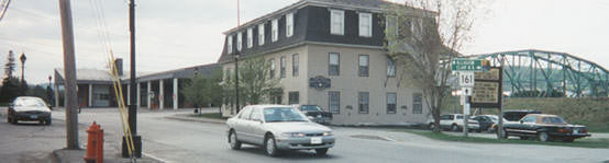
Anyway, let us go back to US 1 and continue "north" (which is actually southwest); here is a photo from a bit further ahead (closer to the bridge):
Picture
Taylor, Oct. 2004
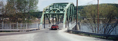
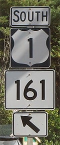
That intersection marks the official north end of US 1: straight ahead is ME 161, and right is the bridge to Clair (the green street sign says "Border Crsg").  If one takes that right turn, this next shot shows the view looking northwest over the bridge to Canada:
Picture
Clements, May 2001
The international boundary here is formed by the St. John River; the town of Clair is on the far side.  US 1 is actually referenced from New Brunswick:
Picture
Poitras, July 2010
Picture
Dienhart, Sep. 2019
That was looking southwest on Rue Principale in Clair (the French equivalent of "Main Street"), approaching the left turn that leads to the bridge over to Ft. Kent (Canadian customs is behind the camera).  Coming over that bridge, one must first stop here...
Picture
Mortell, 1995
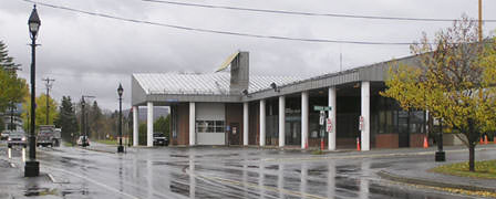
...and then, upon passing inspection, drivers are greeted with this assembly:
Picture
Taylor, Oct. 2004
Picture
Dienhart, Sep. 2019
That sign actually means "TO hwy. 11".  Immediately to the left is the "America's First Mile" monument, and another block in that direction was the wooden signboard mentioned above.  In addition to that, if one goes to the right for about a block, there is another wooden sign at the municipal center (photo).

Anyway, the beginning of US 1 is to the left -- if a driver takes that turn, they will soon see the first "southbound" confirming marker on US 1...
Picture
Taylor, Oct. 2004
Picture
Dienhart, Sep. 2019
...although, as mentioned previously, that bend to the left swings drivers almost due north.  That assembly is at the junction with ME 11, the north beginning of which is currently to the right.  One could make a case that the ME 11 designation should be extended ahead, replacing US 1 until it reaches the bridge at Madawaska.

Historically, traffic heading "south" out of Ft. Kent saw this sign on the roadside.  This was the reciprocal of a similar sign in Key West with nearly identical verbiage:
Picture
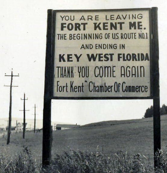
(date and attribution unknown)

Research and/or photo credits: Becky Clements; Paul Dienhart; Robert Mortell; Jacques Poitras; Dale Sanderson; Michael Summa; Steven Taylor
Page originally created 1999;
last updated Oct. 15, 2021.
Copyright © 1998-2023
Picture