End of US highway 68 |
 |
|
1926-1932
|
1932-1956
|
1956-1978
|
1978-present
|
Summa
|
Mileage: in 1989 AASHTO listed a figure of 560 miles for US 68. That closely matches our own 2020 measurement, which yielded 552.1 miles (reroutings and realignments likely explain the difference). Historically, when it ran between Paducah and Toledo, US 68 was 607.2 miles long.
|
|
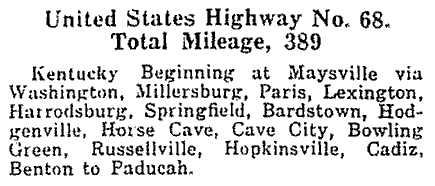
US 68 was an original 1926 route. For the first few years its east end was in Maysville; here is the description from AASHO's Apr. 1927 route log:
|
|
|
Before long US 68 was extended into Ohio. But Maysville was (and is) still the "east" end of US 68, because the route is signed north-south on the Ohio side (for the most part, anyway; photos and more info on the Maysville page). US 68 was extended north to Toledo in 1932. At its west end, US 68 junctioned with US 60 on the outskirts of Paducah, and was duplexed with US 60 into downtown. Based on this map, it seems evident that US 68 would have ended on Broadway at 12th Street, where it junctioned US 45:
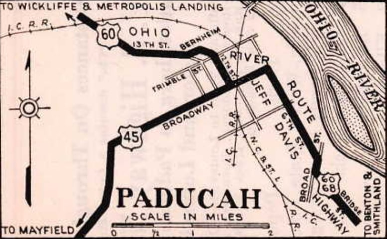
c. 1929, KYDoT
|
US 62 was routed through the area beginning in 1930, so after that the three routes were triplexed into downtown. US 60 and 62 continued west, but US 68 ended in Paducah. By the time of this map, its endpoint appears to have been on Jefferson Street at 8th Street:
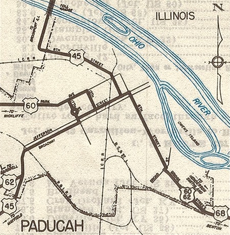
c. 1939, KYDoT
|
Jefferson at 8th may have been an endpoint by the time of that map, but at least one person distinctly recalls an "End US 68" assembly posted on 6th Street at Kentucky Avenue, as this map suggests:
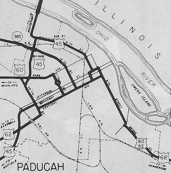
c. 1957, KYDoT
|
This photo was looking northwest on 6th at Kentucky:
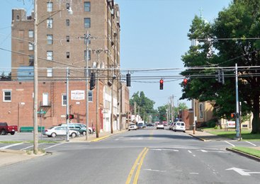
Karner, June 2013
That was US 68's west end until 1978, when I-24 was complete through the area. At that time, the alignment of US 68 was changed to run through interchange 16, and that was when the designation was truncated to its current terminus at Reidland (which is about ten miles east of Paducah). Following is that agenda item from the minutes of AASHTO's meeting in October 1978:
|

|
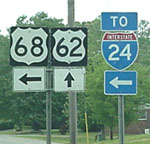
Elkins, 2000
|
Sanderson, July 2007
|
|
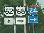
Those photos were taken looking east on US 62; the west beginning of US 68 is to the right. Here is how the assembly for westbound US 62 traffic looked:
|
Elkins, 2000
|
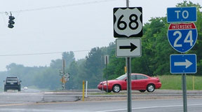
To the left is the west beginning of US 68... and sometime between 2007 and 2013 it was signposted accordingly:
|
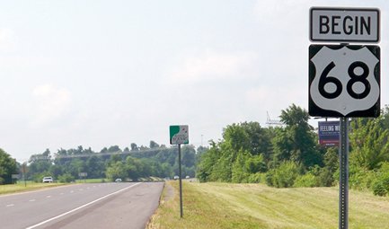
Karner, June 2013
|
|
I-24 (exit 16) is about a mile in that direction. The cars in this photo had just reached the west end of US 68, although they were heading essentially due north at this point:

Elkins, 2000
|
That sign was unchanged as of 2007, but by 2013 an "END" assembly had been posted:

Karner, June 2013
|
In 1956, the US 68 designation was truncated back to Findlay. Although this was before I-75 was complete in Ohio, by then US 25 was already following the route of today's I-75 west of Findlay, and US 68 traffic was routed along its current bypass south and west of the city. Here is the last northbound trailblazer, followed by an "End" assembly that was not posted until sometime after 2016:
Stuve, June 2016
|
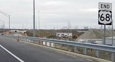
Stuve, Nov. 2019
|
|
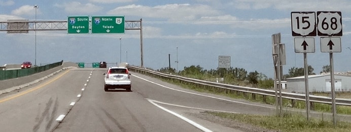
Visible in the distance are the sign bridges marking the north terminus of US 68, at what is now I-75's interchange 156, shown close-up in these photos:
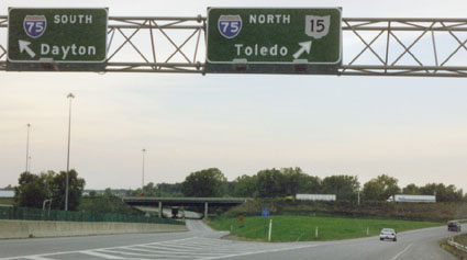
Sanderson, Oct. 2002
|
Stuve, June 2016
|
|
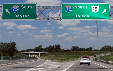
Here is the beginning of US 68 as seen from southbound I-75:
|
Garnell, Oct. 2003
|
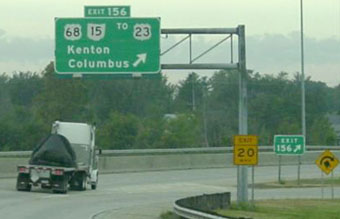
There is a tight loop around to the right; the road passes back under I-75 and then travelers encounter the first southbound US 68 sign:
|
Sanderson, Oct. 2002
|
Research and/or photo credits: H.B. Elkins; Dan Garnell; Don Hargraves; Martin Karner; Mike Roberson; Dale Sanderson; Dwayne Stice; Eric Stuve; Michael Summa
Page originally created 2000;
last updated Dec. 17, 2023.
last updated Dec. 17, 2023.
