Current and historic US highway endpoints in Nags Head, NC
1951-present
 |
|
|
Until the early 1950s, US 64 went only as far east as Ft. Landing, and the east end of US 264 was at Engelhard (where there was a ferry that went across Pamlico Sound to the town of Hatteras). The US 158 designation not only went down to Whalebone Junction in Nags Head, but from there west across the bridge to Roanoke Island, ending at or near Manteo. So back then, one had to drive west on US 158 in order to reach its eastern terminus:
|
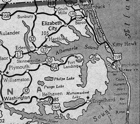
c. 1947, Rand McNally
|
|
US 64 no longer goes through Ft. Landing -- that change occurred in 1951, when both the US 64 and US 264 designations were extended to Whalebone. US 64 traffic was directed onto a new road along the south side of the Little Alligator River (opposite from Ft. Landing). Initially there was neither a bridge across the main Alligator River, nor across Croatan Sound, so ferries were used at both crossings. Meanwhile, US 264 has been extended north from Engelhard, joining US 64 at Manns Harbor. The two were twinned across Croatan Sound to Manteo, and then, running along former US 158, they continued to their new east terminus on the Outer Banks. US 158 was cut back to this junction, so for about 50 years, Whalebone served as a common terminus for three US highways: an unusual distinction.
|
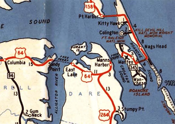
c. 1951, NC DoT
|
|
The original junction was one block east of the current junction, because the original US 158 followed what is now NC hwy. 12 (Virginia Dare Trail) through Kitty Hawk and Nags Head. At Whalebone, that road turned west to cross the Sound, and it was that point where the US 158 designation ended, and the US 64-264 designations began. This interactive image is looking south on Virginia Dare (NC 12). The road to the left allows one to continue south along the Outer Banks, via Old Oregon Inlet Trail (historic NC 12). But this is where the main road veers to the right, to align with the bridge over the Sound. So a driver going that direction was once at the east end of US 158 and the east beginning of US 64-264:
|
|
|
Here is an historic perspective approaching Whalebone Jct. from the west. At the time, this was the east end of US 64-264, and the east beginning of US 158 was to the left on Virginia Dare. (The road straight ahead is now called Gulfstream Street. Visible in the background was the T-junction where that road ended at what was then NC 12, but is now Old Oregon Inlet Trail):
|
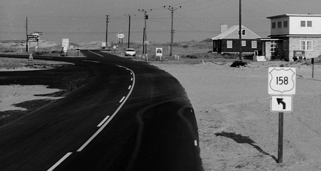
c. 1958, National Parks Service (linked to source)
|
|
The William Umstead Bridge over the Sound was opened to traffic in 1957, and the Alligator River Bridge was completed a few years later (1960). That was about the same time that today's bypass route for US 158 was built through Kitty Hawk and Nags Head: Croatan Highway, which runs just inland from Virginia Dare. (For a time after that, the original US 158 was signed as "Business 158", but that designation was later removed, and Virginia Dare is now signed as NC 12.) Thus the highway junction that marked three endpoints was shifted slightly to the west. That was the situation at the time of the National Park Service map shown here:
|

c. 1999, National Parks Service
|
|
Things changed a few years later: presumably in conjunction with the 2002 completion of the Virginia Dare Bridge over Croatan Sound, the US 264 designation was truncated such that it now ends at its junction with US 64 near Manns Harbor. This photo was looking north on NC 12:
|
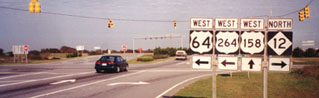
Sanderson, Oct. 1999
|
|
The east beginning of both US 64 and 264 was to the left. That part makes sense -- but then one might find it confusing that straight ahead is also marked "West", and a right turn is "North". Straight ahead is the east beginning of US 158, which -- although it starts out heading north -- eventually turns inland, and is ultimately an east/west route. Northbound NC 12 goes east here for one block to Virginia Dare, and then turns north again, along the original US 158. Here is a shot from southbound NC 12 (which is curving west at this point):
|

Summa, 1999
|
|
Heading east from Manteo, historically there were twin "End" signs...
|
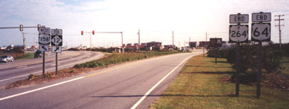
Sanderson, Oct. 1999
|
|
|
...and to the left is the beginning of US 158. There was no "End" sign for US 158 where the road begins its curve towards Manteo, but here are some images showing the approach to its terminus:
|
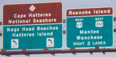
Summa, 1999
|
|
|
The right lanes curve to the west; this photo shows the twin "Begin" signs that were posted at the end of the curve:
|
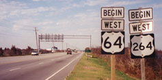
Sanderson, Oct. 1999
|
Today the 264 assembly has been removed. That segment of the road was once just US 158, until the first bridge was built across Croatan Sound. Then it was US 64-264, but now it carries only US 64.
|
Research and/or photo credits: Mike Roberson; Dale Sanderson; Michael Summa
Page originally created 1999;
last updated Jan. 7, 2017.
last updated Jan. 7, 2017.
