End of historic US highway 385 [i] |
 |
Summa
|
|
|
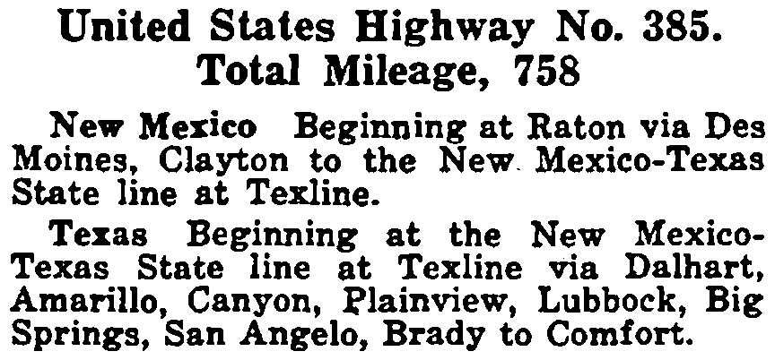
Today's US 385 is the second route to carry that number; it was not commissioned until the late 1950s. The first US 385 was one of the original 1926 routes, but it lasted less than a decade before being re-posted with other US route numbers (mainly US 87). Its route just happened to coincide with modern US 385 between Dalhart and Channing, TX. This excerpt is from AASHO's Apr. 1927 route log:
|
|
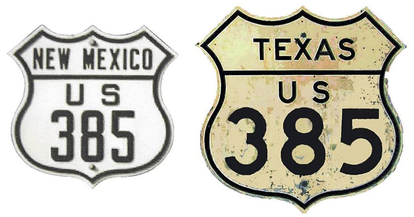
US 385's north end was in Raton. For the majority of its short existence, the south terminus of US 385 was officially listed as "Comfort", but it actually never went through that town. Nearly from the beginning, Texas tried to make that point to AASHO; this excerpt is from a Feb. 1927 letter...

|
...however, since they did not specify a different town name, AASHO continued to refer to the junction as "Comfort".
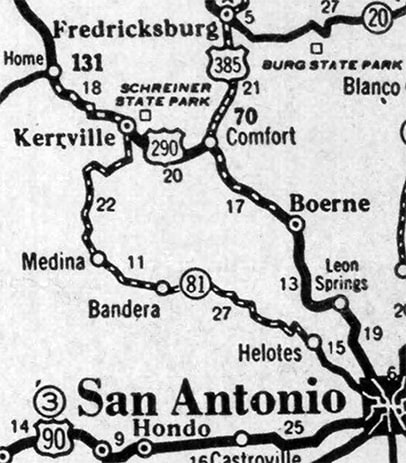
In the early 1920s, the main route between San Antonio and Fredericksburg was along what is now known as the Old San Antonio (or "OSA") Road, which was originally designated TX hwy. 9... that is, via Boerne, Nelson City, Welfare, Waring, Windsor, Fredericksburg Junction, Mt. Alamo, Bankersmith, Grapetown, and Cain City. When the US route system was implemented in late 1926, US 385 was routed south from Fredericksburg via OSA Rd. Its terminus was at its junction with US 290 in a tiny locale known as Nelson City (but because that does not show up on most maps, we have opted to list the terminus at a point "near Comfort"). That endpoint was illustrated on each of the following maps: |
c. 1931, Clasons
|
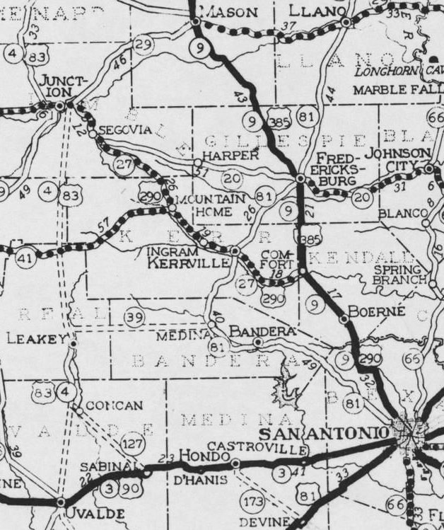
c. 1932, TXDoT
|

c. 1933, Rand McNally
|
|
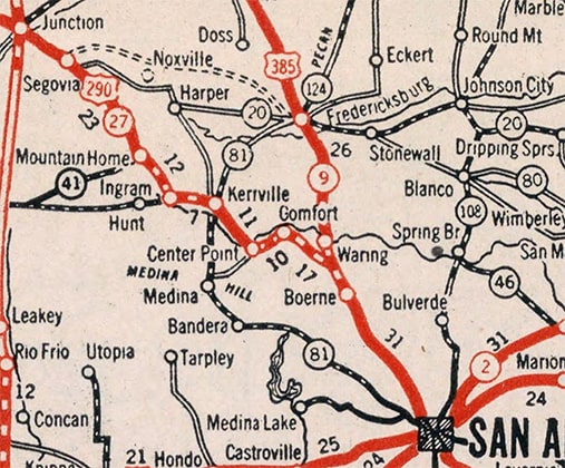
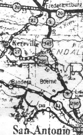
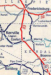
On all of those maps, note how the junction of 385 and 290 is clearly shown as being between Comfort and Boerne (pronounced BUR-nee). Zooming in on the junction, this map clearly showed the roads in question:
|

c. 1936, TXDoT
|
By the time of that map, US 385 was gone -- the road shown as a solid line was US 87-290 (now FM 289). But bridge dates suggest that alignment could not have been open to traffic prior to 1932. So during the timeframe when US 385 ended there, US 290 traffic must have been using the road shown as a dashed line (the one that braids with the solid line). US 385 came from the north through Waring and Welfare, and must have ended at the Y-shaped junction at the center of the map. The three buildings shown just south of there represent Nelson City. Here is a photo from that junction:
|
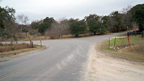
Karners, Dec. 2014
|
That is Waring-Welfare Rd, which continues to the left. But that was once known as OSA Road, and that is where US 385 most likely ended, with US 290 running both directions across the photo (the road continuing off to the right is now called Green Cedar Road). These roads were narrow and twisting (still are), and US 385 was proving to be ill-suited for travel by automobile. Texas planned to improve this situation by building a new road: a more direct route between Fredericksburg and Comfort.
|
|
By about 1932 Texas may have figured the San Antonio/Fredericksburg route (US 385) was at least as important as the San Antonio/Kerrville route (US 290), because some maps indicate that they dual-signed 385 with 290 all the way into San Antonio (maps and more info on that page).
Around 1934-'35, two roughly concurrent changes took place: the Fredericksburg-Comfort highway was completed, removing OSA Rd from the US route system... |
c. 1934, Rand McNally
|
...and US 87 was extended through the area, replacing the 385 designation. Although the 1935 TXDoT map did not indicate a 290/385 overlap into San Antonio, it did show the new Fredericksburg-Comfort highway had been completed:
|
c. 1935, TXDoT
|
Texas' official map from the following year (1936) showed that US 290 had been rerouted east from Segovia along its current corridor through Fredericksburg, and that US 87 had replaced US 385 down to San Antonio and beyond. This 1938 map illustrates that, and it is also interesting because it still shows OSA Rd (historic US 385) through Waring:
c. 1938, Rand McNally
|
Research and/or photo credits: Jenn Dolari; Robert Droz; Karin and Martin Karner; Dale Sanderson; Michael Summa; Steven Taylor
Page originally created 2002;
last updated Dec. 11, 2023.
last updated Dec. 11, 2023.
