Gaps in US highways
|
Why some US routes consist of two separate segments
|
 |
|
The initial reason I envisioned this page was because there were a couple factoids that needed to be addressed: 1.) US routes do not exist within the boundaries of Yellowstone National Park, and 2.) for that reason some US highways consist of two non-contiguous segments. But then of course there are other US routes with gaps that have nothing to do with Yellowstone. So ultimately I decided to create a page which covers all of the US routes that have various types of discontinuities.
|
Some of these discontinuities have been acknowledged by AASHTO, while others have not, so they can be classified into two broad categories: official gaps and unofficial gaps.
|
Official gaps
|
By "official" I mean either 1.) gaps that were acknowledged in AASHTO's route log, or 2.) gaps that were not mentioned in the route log, but were nevertheless made official by AASHTO action (or AASHO prior to 1973). We will begin with the first type, and Yellowstone National Park provides several examples.
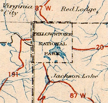
Since the very beginning of the US route system, US highways have never gone through the Park. Actually, there is one exception to that statement (which we will discuss later), so to be more accurate: US routes have never gone through the main part of Yellowstone, i.e. never along any segment of the Grand Loop Road. Rather, US highway designations have always ended at the National Park boundary. However, some of those designations resume on the opposite side of the Park. From the outset, there were examples of both; this is a clip from the US highway map that AASHO released in November 1926, which accompanied their announcement of the brand-new US route system: |
c. 1926, AASHTO
|
US 87W
|
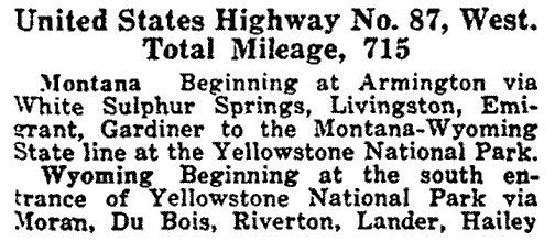
At the time, US route 191 ended at Yellowstone's west entrance, while US 20 ended at the east entrance (as a matter of fact, US 20[e] still ends there). Notice that US 87W was shown on the north side of Yellowstone as well as the south, but it was not shown as passing through the Park. That was reiterated in AASHO's inaugural route log of April 1927. Notice that the description of US 87W indicated a gap in the route between Gardiner (i.e. Yellowstone's north entrance) and the south entrance:
|
|
|
US 89
US 87W existed for only a few years. To the north of the Park, it followed what is now US 89, and to the south it followed what is now US 287. Those designations were implemented already by the mid-1930s, and were illustrated on this map:
|
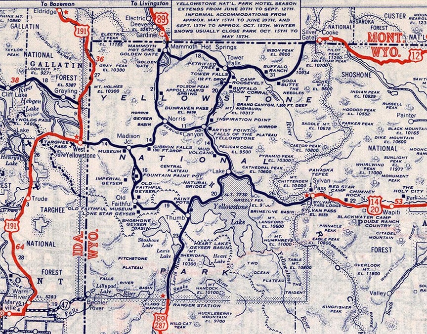
c. 1939, Rand McNally
|
|
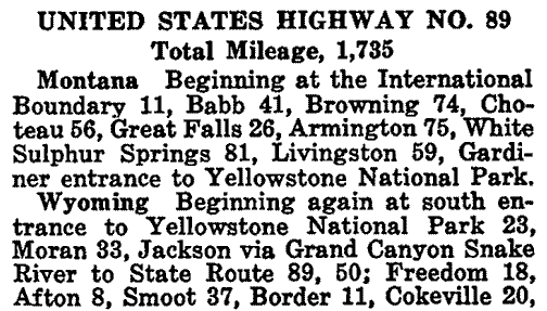
Also by that time both US 12 and US 14 had been extended to the Park, ending at the northeast and east entrances, respectively. US 20 still ended at the east entrance, but US 191 no longer quite made it to the west entrance. Instead it turned north at West Yellowstone, becoming the first (and only) US route to be designated within the boundaries of Yellowstone (more on that below). US 89 had replaced US 87W as the only US route assumed to go "through" the Park (even though the US 89 designation did not exist within the Park itself). Here is the relevant part of that route's entry from AASHO's 1935 route log:
|
|
"Implied" routes
That is a term that is often used in the road enthusiast community, as in "US 89 has an implied route through Yellowstone". I have no objections to that term, as long as we can agree on exactly what is "implied". Since there were (and are) US routes with the same number on opposite sides of the Park, it is obvious there was an implication that drivers on one of those US highways could pass through Yellowstone and then resume travel on that same route. However, no specific route through the Park has ever been implied. For example: is US 89 traffic supposed to use the west Grand Loop or the east Grand Loop? That is a question that cannot be answered, because either option would work (as would any hybrid option using some combination of both sides). So it is up to each individual driver, and NPS has never made any attempt to influence that decision by defining the route of US 89 through Yellowstone.
So already by 1935, US 89 consisted of two separate sections. Ever since then, if someone wants to know the mileage of "US 89", the answer is actually somewhat complicated. One option would be to simply add the mileage of US 89[n] and US 89[s]. That is the approach AASHTO typically took, back in the days when they published route logs. On their most recent (1989) route log cover page, they provided a figure of 1837 miles for US 89. But they also pointed out those numbers included any associated bannered routes, and when we examine the 1989 route log details, we find that US 89's total included US 89[n] + US 89[s] + two US 89 alternate routes. So, obviously not an accurate reflection of end-to-end mileage. When we subtract out the alternate routes, AASHTO's 1989 measurement of mainline US 89 would have been 1661 miles. However, that does not account for the mileage one would have to travel through Yellowstone in order to bridge the gap between the north and south segments of US 89. But on the other hand, since US 89 does not exist in Yellowstone, any number which includes mileage in Yellowstone would also produce an inaccurate total. And as if all that is not enough, US 89 has since been truncated from Nogales to Flagstaff. So, taking all of that into account, as of 2020 our own mileage breakdown was as follows:
- US 89[n] (all in MT): 399.7 miles
- US 89[s] (WY through AZ): 839.3 miles
- Both segments of mainline US 89 combined (which is a somewhat meaningless total because they are not connected): 1239.0 miles
- Total mileage along US 89 between Flagstaff AZ and Piegan MT, including the shortest connection through Yellowstone (which is misleading because that segment is not a part of US 89): 1333.8 miles
A note about US highway nomenclature: anything I have shown in [brackets] is not an official part of the US route designation. For example, both US 89[n] and US 89[s] are signposted in the field simply as "US 89". AASHTO's route logs differentiated the two by referring to them as "US 89 north section" and "US 89 south section". On this page (and throughout this website) I have streamlined this nomenclature by using [n] and [s], or in other cases [e] and [w].
US 20
As noted previously, what is now US 20[e] was around from the very beginning, running between Boston and Yellowstone's east entrance. Then in about 1940 a separate section of US 20 was commissioned: US 20[w] runs from West Yellowstone to Oregon. So, how long is "US 20"? Again, it's complicated. In 1989 AASHTO claimed 3365 miles, although by their own admission that figure included 128 miles worth of bannered routes associated with US 20. Subtracting those out, the 1989 mainline mileage would have been 3237. However, since 1989 some sections of US 20 have been realigned and shortened. Following are our own measurements as of 2020:
- US 20[w] (OR through MT): 856.8 miles
- US 20[e] (WY through MA): 2346.5 miles
- Both segments of mainline US 20 combined (which is a somewhat meaningless total because they are not connected): 3203.3 miles
- Total mileage along US 20 between Boston and Newport, including the shortest connection through Yellowstone (which is misleading because that segment is not a part of US 20): 3283.2 miles
- The question (whether those last two figures represent a valid way of measuring US 20) is important, because it impacts where US 20 ranks among the longest highways in the U.S.
US 287
US 287 was commissioned in 1935, with its north end at Yellowstone's south entrance. In 1965 US 287 was implied to extend through the Park to West Yellowstone, then continuing north from there. In 1989 AASHTO published a figure of 1891 miles for US 287 (which did not include any bannered routes). As of 2020 we measured US 287's two sections as follows:
- US 287[n] (all in MT): 281.2 miles
- US 287[s] (WY through TX): 1604.5 miles
- Both segments of mainline US 287 combined (which is a somewhat meaningless total because they are not connected): 1885.7 miles
- Total mileage along US 287 between Choteau MT and Pt. Arthur TX, including the shortest connection through Yellowstone (which is misleading because that segment is not a part of US 287): 1954.5 miles
- The question (whether those last two figures represent a valid way of measuring US 287) is important, because it impacts whether or not US 287 is the longest three-digit US route.
US 191
Previously we discussed how US 191 initially began at West Yellowstone and went south from there. Then in 1934 US 191 was extended north from West Yellowstone. But in about 1980 the US 191 designation was removed from its original segment (West Yellowstone to Idaho Falls), and instead US 191 was assumed to pass through the National Park, re-emerging at Yellowstone's south entrance. Here are our 2020 measurements:
- US 191[n] (MT and WY): 440.0 miles
- US 191[s] (WY through AZ): 1211.3 miles
- Both segments of mainline US 191 combined (which is a somewhat meaningless total because they are not connected): 1651.3 miles
- Total mileage along US 191 between Douglas AZ and Morgan MT, including the shortest connection through Yellowstone (which is misleading because that segment is not a part of US 191): 1720.1 miles
- The question (whether those last two figures represent a valid way of measuring US 191) is important, because it impacts where US 191 ranks among the longest three-digit US routes.
So that makes four US routes (20, 89, 191, and 287) that have implied but undefined connections through Yellowstone. But there are other US highways that have gaps which are unrelated to Yellowstone:
US 2
|
US 2 is the lone example that involves an international boundary. US 2[e] runs through a few New England states and then ends essentially at the Canada border south of Montreal, while US 2[w] runs between Michigan and Washington. This clip from the 1927 route log described the routes on both sides of that discontinuity:
|
|
Historically US 2[w] could be conceptualized as a "reappearance" of US 2[e] into the U.S. from Canada at Sault Ste. Marie. But in 1984 the segment of US 2 between SSM and St. Ignace was decommissioned, so now it makes even less sense to think of US 2 as a single highway with an implied routing through Canada. However, that didn't stop AASHTO from publishing a combined total of 2643 miles on their 1989 route log cover page. But more accurately, "US 2" actually comprises two separate routes that happen to share the same number. Here are our 2020 measurements:
- US 2[e] (ME through NY): 459.8 miles
- US 2[w] (MI through WA): 2114.9 miles
- Both segments of mainline US 2 combined (which is a meaningless total because they are separated by over 700 miles): 2574.7 miles
- Total mileage along US 2 between Houlton ME and Everett WA, including the shortest connection through Canada and Michigan (which is very misleading because that 700+ mile segment is obviously not a part of US 2): 3277.7 miles
US 422
In the original 1926 list of US routes, there was only one US 422: the one running between Cleveland and Ebensburg PA. But Pennsylvania did not begin signposting their routes until 1928 because they had numerous objections to AASHO's plan, and they threatened to leave their US routes unmarked unless AASHO acquiesced to their demands. One of their requests was to re-number the segment of US 120 between Philadelphia and Reading as US 422. AASHO immediately recognized that this would create two non-contiguous segments of US 422, and in June 1927 they questioned Pennsylvania about it:
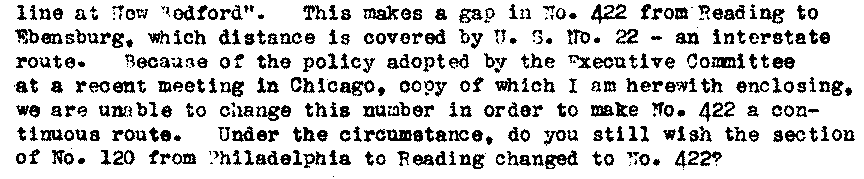
Undaunted, Pennsylvania instructed AASHO to forge ahead with the change...
...and thus was born the strange situation with two separate routes numbered US 422. I mean "strange" in the sense that all other official gaps in US routes were there because of jurisdictional issues, i.e. because a foreign country or a National Park was situated between the two highway segments. But that was not the case with US 422. Rather, this gap came about because Pennsylvania's ideas about the US route system were not in complete alignment with AASHO's original intent, and within their own boundaries Pennsylvania was determined to mold the US route system into something that conformed to their slightly peculiar vision. Here are our 2020 measurements:
- US 422[e] (King of Prussia to Hershey PA): 82.9 miles
- US 422[w] (Cleveland to Ebensburg PA): 187.5 miles
- Both segments of mainline US 422 combined (which is a meaningless total because they are not connected): 270.4 miles
- Total mileage along US 422 between Cleveland and King of Prussia, including the shortest connection between Ebensburg and Hershey (which is misleading because that segment is not a part of US 422): 426.4 miles
US 10
It should be acknowledged that in AASHTO's latest route log, there was one additional highway that was listed as having two separate sections: US 10. This was because of its ferry segment across Lake Michigan. It seems odd that US 10 was considered to have two segments, whereas US 9 (which also has a ferry segment) was listed as a single route. Regardless, the point is moot now, because a 2015 AASHTO action made the Ludington-Manitowoc ferry an official part of US Route 10. So US 10 no longer has an official gap in its route. However, I do consider both US 9 and US 10 to have unofficial gaps; I discuss those more later on this page.
A bit more about National Parks
Above I mentioned that US 191 is the one exception to the statement that no US routes go through Yellowstone (this blog post has more info). To be clear: US 191 does have a gap through the Park, between West Yellowstone and the south entrance (as noted above). However, the Montana segment of the highway between West Yellowstone and Big Sky is all considered by AASHTO to be part of US 191. That includes a 20.2 mile segment that crosses inside the northwest corner of Yellowstone (although there is no entrance gate/fee station on either end). US 191 is reportedly even signposted through that Yellowstone segment (which includes a 5.9 mile stretch that passes in and out of Wyoming).
So it is not entirely accurate to say that no US routes exist in Yellowstone. Moreover, it is absolutely incorrect to assume that the National Park Service has a broad policy that disallows US route designations within any of its holdings. For example, US 34 and US 36 both run through Rocky Mountain NP; US 33 and US 211 both run through Shenandoah NP. So it is up to individual Parks to decide whether or not to signpost US routes within their boundaries. However, there is another National Park that is similar to Yellowstone in terms of how it handles US routes, and that brings us to another subcategory...
So it is not entirely accurate to say that no US routes exist in Yellowstone. Moreover, it is absolutely incorrect to assume that the National Park Service has a broad policy that disallows US route designations within any of its holdings. For example, US 34 and US 36 both run through Rocky Mountain NP; US 33 and US 211 both run through Shenandoah NP. So it is up to individual Parks to decide whether or not to signpost US routes within their boundaries. However, there is another National Park that is similar to Yellowstone in terms of how it handles US routes, and that brings us to another subcategory...
Gaps made official by AASHTO action
...or, in this next example involving US 441, it would be more accurate (but also more verbose) to say "Gaps made official when AASHO acknowledged that they do not have the authority to designate US routes within National Parks".
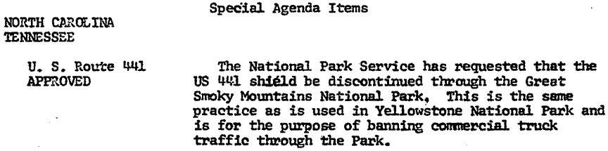
US 441
Until the early 1950s, US 441 ran only between Florida and Georgia. But in 1951 GA, NC, and TN asked AASHO to extend the route north through Great Smoky Mountains National Park. Each of those state DOTs cited a desire to make travel to the Park easier for its many visitors:
1951, from Georgia to AASHO

1951, from North Carolina to AASHO
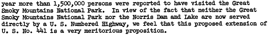
1951, from Tennessee to AASHO
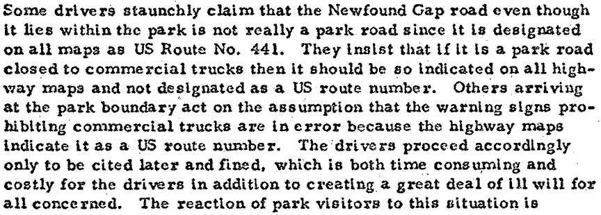
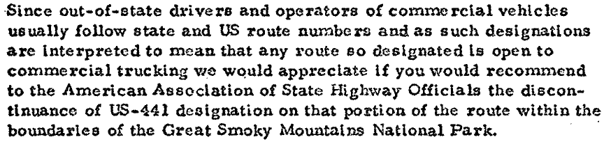
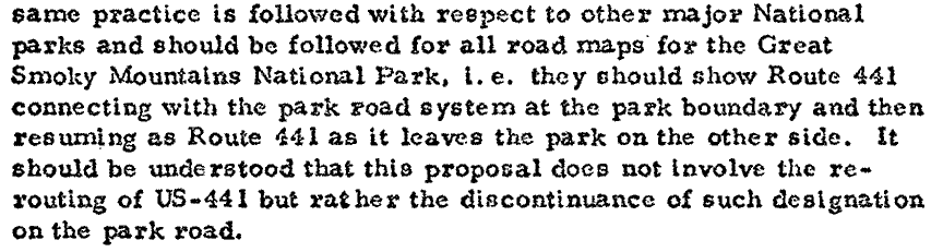
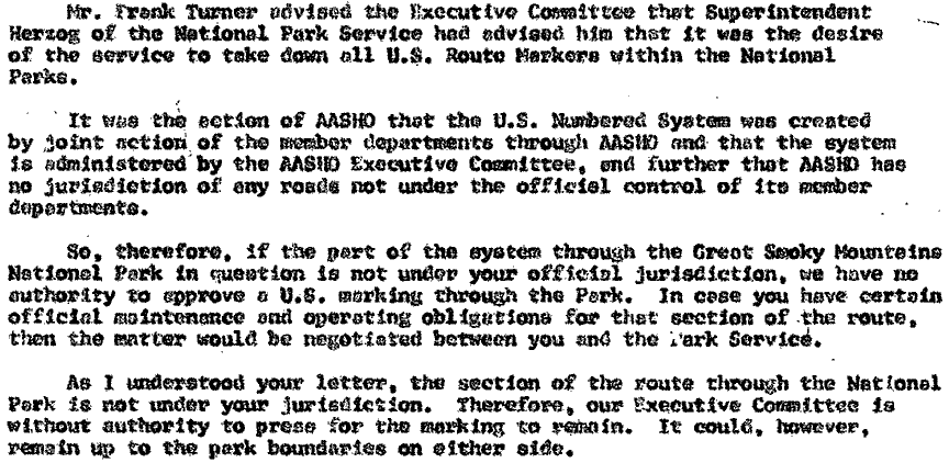
I have not seen any evidence that the National Park Service was consulted during that process, but even if they had been, I doubt NPS would have objected at the time... after all, making travel easier is not just a legitimate function of DOTs, it is one of the prime directives. AASHO approved the state DOTs' request, and for almost the next two decades, US 441 was signposted through GSMNP. However, during that timeframe, commercial truck traffic using US 441 as a through route across GSMNP increasingly became a problem. Commercial traffic was prohibited in GSMNP when I-40 opened to traffic in 1968, but apparently some trucking companies/drivers were confused because the road through the Park was still signed as a US route. The following three excerpts are from a 1970 letter written by the GSMNP superintendent to NC DOT:
At their November 1970 meeting, AASHO approved NPS's request to remove US 441 signs through the Park. Here is an excerpt from the actual minutes of that meeting...
...but as subsequent correspondence reveals, there were a lot of people and organizations (including NC DOT) who were not pleased with that decision. In the following 1971 excerpt, AASHO made it clear to NC DOT that their decision was based upon the fact that they do not have jurisdiction over NPS roads (or any roads that are not maintained by the state highway departments which form AASHO's membership):
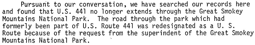
The questioning of AASHO's decision continued for literally years afterward. AASHO became AASHTO in 1973, and following is their 1975 response to an inquiry from the City of Gatlinburg...
...and here is AASHTO's 1977 response to a letter from a Tennessee Congressman, who was demanding that the US 441 designation be reinstated:
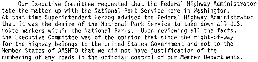
During all these years of controversy, AASHO/AASHTO was consistently clear about the fact that they do not have the authority to establish a US route through a National Park. Rather, it is up to the Parks to determine whether or not US routes should be recognized and/or signposted through their properties. GSMNP does not refer to Newfound Gap Road as US 441; they do not label it as US 441 on their official maps; and they do not signpost the road with US 441 shields. Furthermore, in their letters reproduced above, NPS clearly communicated their desire for the "discontinuance of the US 441 designation". Since NPS has the authority to make that decision, it follows that US 441 no longer officially exists within GSMNP. However, despite AASHTO's concurrence on that point, their 1989 route log still did not show US 441 as having a north section and a south section. Nevertheless, the conclusions outlined above clearly indicate that US 441 has an official gap, even though that fact has been overlooked in AASHTO's route log.
|
Here is the mileage breakdown as of 2023:
As of the last time I checked Google Maps, the former segment of US 441 through GSMNP was still labeled with a US 441 shield; you can check whether that is still the case by viewing this next map. The red segment has not officially been designated US 441 since 1970: |
|
In addition to US 441, there are at least a couple more US routes that have similar gaps... at least in the sense that they are not noted in the route log but were still made official by AASHTO action. The difference is that I consider them to be... well, "illegitimate" for lack of a better word. I will discuss those more towards the end of this page. But for now we will skip to the next major category:
Unofficial gaps
By "unofficial" I mean the gaps in these routes were neither created by AASHTO nor are they recognized by AASHTO. Nevertheless, it would be absurd to act as if they do not exist. I have classified these unofficial gaps into two subcategories: "defacto gaps" (which physically cannot be traversed) and "perceived gaps" (which are not technically gaps but can easily be perceived as such), and under each of those headings are additional subclassifications. Let us begin with real, physical gaps:
|
Defacto gaps
One of the best examples was US 87 in Wyoming. In the 1990s a segment of US 87 was damaged by a series of landslides (the red segment shown on the following map). For various reasons WYDOT opted not to rebuild the road, and instead asked AASHTO to shift the US 87 designation onto SH 193 (blue segment). AASHTO refused, suggesting instead that WYDOT direct US 87 traffic onto I-90. WYDOT rejected that idea, and for the next three decades the whole situation was at an impasse. AASHTO still considered US 87 to run along the red and orange segments, even though that road literally cannot be used for the purpose of through traffic. WYDOT changed the geometry of the highway junctions such that US 87 traffic seamlessly flows onto SH 193 and back again, but out of deference to AASHTO they did not signpost SH 193 as US 87. Finally in 2023 AASHTO accepted WYDOT's proposal to move US 87, so the US 87 labels that had been shown on Google Maps all along are actually correct now:
|
|
Seasonal gaps
US 34 and US 212 both go over high-altitude mountain passes that receive heavy snowfall. These road segments are not cleared of snow during the winter months, so they are closed to traffic seasonally. And winter lasts a long time in the Rockies; in fact, on an annual basis these sections are actually closed to traffic for a longer period of time than they are open. The red segments shown on the maps below are closed annually, which has the effect of dividing their respective US routes into two disconnected sections:
|
|
 |
|
The preceding photo was taken looking east on US 34 at Many Parks Curve, which marks the point where the highway closes for the winter season ("winter" being June in that case). The photo below was looking east on US 212 where it closes annually (with Hellroaring Plateau visible in the background):

Google Maps Street View, Nov. 2021
|
|
Perceived gaps
Above we briefly touched on the fact that US 9 and US 10 both have ferry segments. Those ferries are officially considered part of the US routes, so technically there is no gap in US 9 or US 10. Nevertheless, these segments have a significant difference when compared to any other US highway, because obviously neither the car nor the driver has an active role while in transit between the ferry docks. So these segments of US 9 and US 10 could be thought of as "perceived gaps due to mode of transportation". And one might be particularly inclined to perceive a gap in US 10 when they see the erroneous "US 10 Ends" sign that Michigan has been known to post at the approach to the Ludington ferry dock.
Signage gaps
Motorists also perceive a gap in a US route in places where no US highway shields are posted on the road to reassure them, or to direct them to make a turn, or to take an exit. There are innumerable examples of missing signs, and in most cases the lack of signage is unintentional on the part of the state DOT. Signs get damaged, or they fade to illegibility, or they get stolen. Or sometimes the sign maker (either the DOT sign shop or a private contractor) omits a US route shield simply due to oversight or human error.
However, there are some DOTs that intentionally do not sign some of their US routes. Most often this is done in places where the US highway joins with an Interstate highway, but only the Interstate route is signposted. From AASHTO's perspective the US route exists along with the Interstate, but from a driver's perspective there is nothing to inform them that the US route exists along that segment. The reason commonly given for this type of signage policy is to reduce expense, driver confusion, and "sign clutter". Arkansas is known for this practice, as are some other states, but it is probably Colorado that is most notorious for it. As just one example: between north Denver and the town of Byers, US 36 traffic ostensibly follows a 43-mile segment along Interstates 70 and 270. However, there is no signage directing US 36 traffic onto those Interstates, nor is there a single reference to US 36 anywhere along that entire stretch. And many other US routes that enter Colorado have a similar signage gap where they join an Interstate, including US 6, US 24, US 40, US 50, US 85, US 87, US 287.
However, there are some DOTs that intentionally do not sign some of their US routes. Most often this is done in places where the US highway joins with an Interstate highway, but only the Interstate route is signposted. From AASHTO's perspective the US route exists along with the Interstate, but from a driver's perspective there is nothing to inform them that the US route exists along that segment. The reason commonly given for this type of signage policy is to reduce expense, driver confusion, and "sign clutter". Arkansas is known for this practice, as are some other states, but it is probably Colorado that is most notorious for it. As just one example: between north Denver and the town of Byers, US 36 traffic ostensibly follows a 43-mile segment along Interstates 70 and 270. However, there is no signage directing US 36 traffic onto those Interstates, nor is there a single reference to US 36 anywhere along that entire stretch. And many other US routes that enter Colorado have a similar signage gap where they join an Interstate, including US 6, US 24, US 40, US 50, US 85, US 87, US 287.
|
Illegitimate gaps
Above I mentioned that there are some gaps which were made official by AASHTO action, yet I consider them to be illegitimate. Why? These are decisions that were made in recent years, a timeframe during which AASHTO's Special Committee on Route Numbering often seems to operate as if they have lost sight of some basic conditions that need to be in place before a road can be approved as a US route. One seemingly-obvious requirement of a US route is: motorists should be able to drive the route from one end to the other. Yet in 2009 AASHTO approved a change to a US route that made it impossible for drivers to follow that route. I will try to explain using this screenshot taken from OTIS (Colorado DOT's Online Transportation Information System). The basemap shows all roads in white; roads overlaid in red are CDOT's responsibility. The highway on the left is I-25. On the right is CDOT's definition of US 85:
|
CDOT, accessed Jan. 2023
|
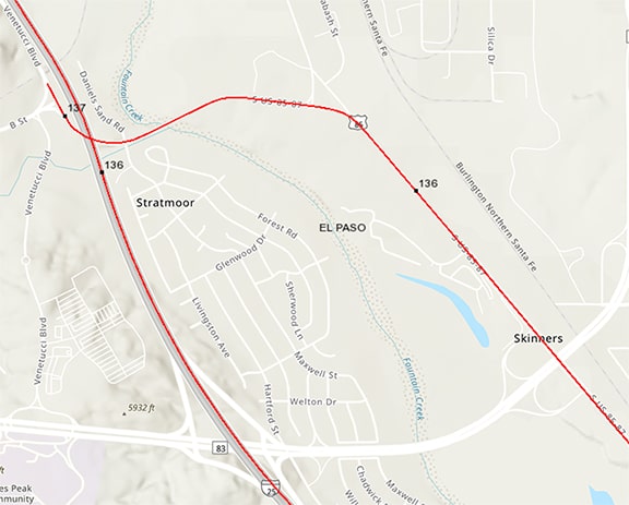
Towards the upper left, US 85 uses a freeway overpass (which provides no access to I-25), and then upon resuming a northerly direction, US 85... just ends. According to CDOT, US 85 continues north from that point by using I-25, but that is easier said than done, because there is no way for drivers to make that movement. Traffic continuing north on Venetucci Boulevard is on a locally-maintained road that CDOT insists is no longer US 85. So the only other option would be to turn around, backtrack about 1.5 miles to Academy Boulevard, and then use that to get on I-25. But Academy is no longer a state highway either, and CDOT has not posted signs directing US 85 traffic to use Academy.
|
This is a colossally ridiculous arrangement, and AASHTO never should have approved it. In their 2009 application to AASHTO, CDOT included a small-scale, low-detail map which served to downplay the fact that US 85 has no access to I-25 at that point. AASHTO should have told CDOT, essentially, "If you want this laughable arrangement to be part of your state highway system, that's your call, but you do not have permission to use a US route shield on a dead-end segment like that. You may move US 85 traffic over to I-25, and change this nine-mile segment of US 85 to a state highway designation. Or you may come up with a different solution, but US 85 must be a continuous route."
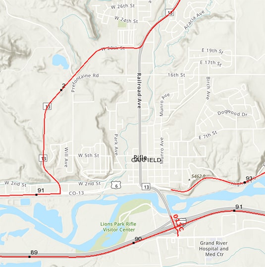
Unfortunately, that was not the last of the nonsense coming out of Colorado. In 2015 CDOT removed from their inventory a one-mile segment of US 6 in Rifle, turning it over to the City for maintenance. On this map, US 6 runs horizontally along the north bank of the river, and you can see that there is no red line where it passes through the main part of Rifle: |
CDOT, accessed Jan. 2023
|
Across the country there are many, many segments of US routes like that (i.e. they are maintained not by the state DOT but rather by a more local entity, such as a county, a township, a city, etc.) I am not aware of any other state that reports those situations to AASHTO, but for whatever reason CDOT felt the need to get AASHTO involved. And rather than simply reporting it to AASHTO, they actually asked AASHTO to decommission this one-mile segment of US 6. AASHTO should have responded, "This is of no concern to us, and we are not going to create a tiny discontinuity in the middle of a 3200-mile route simply because it is maintained by a municipal government. If you don't want to allow a local government to signpost a US route, then you are welcome to move US 6 traffic onto I-70, but US 6 must be a continuous route." So, what was AASHTO's actual response? Well, they... just approved it. Shaking my head in disbelief.
Research and/or photo credits: Tom Fearer; Dale Sanderson
Page originally created 2023;
last updated May 20, 2024.
last updated May 20, 2024.
