Current and historic US highways in Maysville, KY and Aberdeen, OH
|
1927-present
|
 |
|
US 68 was among the original 1926 routes, and US 62 was brought into the system in 1930. Toward their east end, they joined at Washington KY, and overlapped to a common terminus in Maysville. They did not quite make it to US 52 at Aberdeen, presumably because there was no span over the Ohio River then...
|

c. 1930, ODoT
|
|
...however, there was a ferry, and US 62-68 traffic was directed to the landing. Drivers coming in on 3rd Street went about a block past today's bridge approach, then north on Limestone Street. Today the foot of Limestone has been converted to a pedestrian-only area, but this photo illustrates how things used to be:
|
Gray, Jan. 2013 (linked to source)
|
|
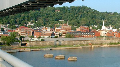
In the foreground is a gap in the floodwall. Beyond that is the elevated railway. Through the underpass the Ohio River is visible; that is where the original ferry landing was located, and that is where US 62 and US 68 originally ended. A few years later, in 1931, the Simon Kenton Bridge was opened to traffic. Perhaps in 1926 it was already planned (or was under construction), and maybe that is why these highways were signed into Maysville in the first place: because they would soon be able to continue across the river. This photo was taken from the bridge, looking back towards Maysville:
|
James, May 2008
|
At lower left the railroad underpass is visible, leading to what is now known as "Limestone Landing", the original highway terminus. When this bridge was completed in 1931, it is possible that the US 62-68 designation was extended across the river, to the junction with US 52 in Aberdeen. But even if so, that would have been very short-lived, because US 62 was extended up to Niagara Falls in 1932, and the following year US 68 was extended up to Toledo.
The Maysville-Aberdeen area is interesting in terms of highway signage. Navigating through this area can be difficult and/or amusing (depending on how comfortable a driver is with where they are going) for a couple reasons:
- US 68 is signed as an east-west route in Kentucky, but it is north-south in Ohio. The Maysville area is where directional signage changes.
- US 62 is signed as an east-west route in both states, but it could just as easily be considered more of a north-south road in this area. And partly for that reason, there are some confusing "wrong-way" concurrencies.
|
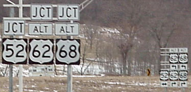
This first group was in Aberdeen, looking south from US 52 across the old Simon Kenton bridge over the Ohio River into Maysville. This was formerly mainline US 62-68...
|
Elkins, Mar. 2001
|
Sanderson, Oct. 2002
|
...and that first photo shows how the signage probably appeared for decades. Interestingly though, at the time of that photo, the Harsha bridge was already open, mainline US 62-68 had been routed over it, and that segment had actually been re-signed as "Alternate US 62-68" (more on that below). Sometime later in 2001, Ohio replaced the "Alt" designation with a "Business" designation.
|
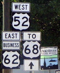
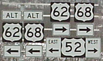
Anyway, in both photos, US 68 was signed as "South". Across in Maysville, the next couple shields had only arrows; the first assembly with a directional tab included was just past the intersection with KY hwy. 10 (Kentucky Avenue):
|
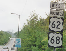
Sanderson, Oct. 2002
|
|
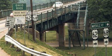
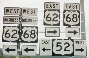
There, US 68 was signed as an east-west route. So that old bridge formerly marked the spot where US 68 changed its direction. Now, imagine turning around and crossing the bridge: Bus. 62 and Bus. 68 were both signed all the way to the state line...
|
Elkins, June 2012
|
|
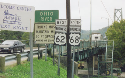
...but as soon as one crossed over into Ohio, things changed a bit:
|
Elkins, June 2012
|
|
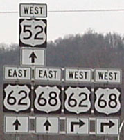
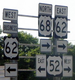
Ohio no longer signs Business 68. They still sign Business 62, but now it is "TO US 68". If one takes that left turn, the confirming assembly looked like this:
|
Sanderson, Oct. 2002
|
Elkins, June 2012
|
|
Since US 68 is a north-south route in Ohio, that caused a potentially-confusing "West-East-North" multiplex... which is possibly the reason Ohio changed it.
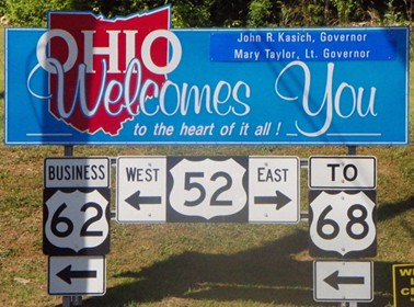
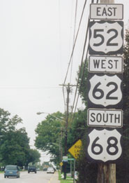
A mile or two ahead, drivers come to the landing for the Harsha Bridge. This serves as the new US 62-68, so its landing marks the Ohio terminus of Business 62 (and the former terminus of Bus. 68). Here is how that spot has been signed: |
Elkins, Jan. 2001
|
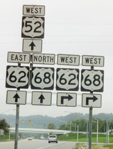
Sanderson, Oct. 2002
|
Elkins, June 2012
|
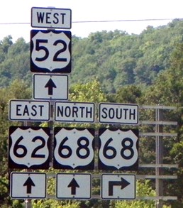
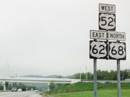
There are not many places where an assembly like that second one can be found, with a single route having both "North" and "West" directionals. Recently the US 68 sign was changed from "West" to "South", and the US 62 sign has been completely removed (it is unclear why either of those changes were necessary).
|
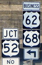
To cross over into Kentucky, one takes a right, loops around, and flies back over to the left. Traffic coming over from Kentucky loops around using the same road and ends up at the same intersection. Initially, approaching that intersection, drivers viewed these signs:
|
Elkins, Jan. 2001
|
Elkins, Jan. 2001
|
|
Note how US 52 is signed with a different format than the other routes. That has not changed. But now -- apparently on this sign only -- Ohio signs US 68 (both the mainline and the business route) as an east-west road. Also notice how west on 52 is "east" for the other two routes, and vice versa. This may a case where the directional tabs for US 62-68 should be left off:
|
Sanderson, Oct. 2002
|
Elkins, June 2012
|
|
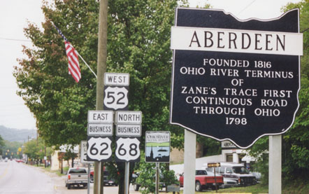
Turning right from there (west on US 52), the highway has been signed in these ways:
|

Elkins, Jan. 2001
|
Sanderson, Oct. 2002
|
|
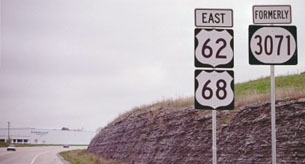
That wrong-way multiplex exists for another 8 miles to the west, where US 62-68 splits off from US 52 at Ripley OH. This was the signage heading east out of Ripley towards Aberdeen:
|
Sanderson, Oct. 2002
|
|
Most trailblazers between those two towns lacked directional tabs, but that was one exception. And finally, this assembly was posted where US 62-68 splits off from the "AA" highway (also KY 9-10) and begins its approach to the Harsha Bridge:
|
Sanderson, Oct. 2002
|
Incidentally, that was not the last trailblazer on the Kentucky side; there was one more just past the junction with KY 3056. But all signs I observed in Maysville were consistently east-west.
Research and/or photo credits: H.B. Elkins; Bo Gray; Carl James; Dale Sanderson
Page originally created 2002;
last updated June 10, 2016.
last updated June 10, 2016.
