Historic US highway endpoints in Amarillo, TX
|
1926-1939
|
 |
Amarillo may well be the grand champion of decommissioned highways (or grand loser, depending how one looks at it): of the eight US routes that have served the city, five of them no longer exist. That could be a misleading statement, though, so to clarify: it is not that the roadways themselves have disappeared. Rather, Amarillo was originally served by several shorter branch routes, which were later swallowed up by extensions of longer routes. As a result, several US route numbers that once graced the streets of Amarillo have been retired -- perhaps more than any other city.
|
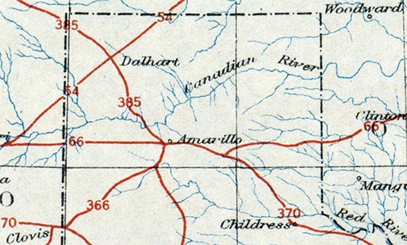
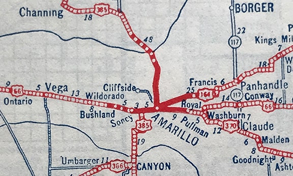
When the US routes were first commissioned in 1926, Amarillo found itself at the junction of north-south US 385[i] and east-west US 66. Also, US 366[i] came into town heading northeast from El Paso. It met US 385 at Canyon (about 16 miles south of Amarillo), but instead of ending there, it overlapped with US 385 up to Amarillo. This is a detail from the Nov. 1926 map that AASHO published to illustrate the inaugural US routes:
|
c. 1926, AASHO
|
|
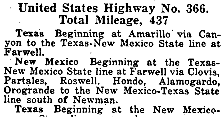
Most maps (including that one) were not detailed enough to label the US 366-385 concurrency between Canyon and Amarillo. So how do we know US 366 did not end in Canyon? For one thing, its number implies that it connected to US 66 (which went through Amarillo). But even more convincingly, AASHO's April 1927 route log stated that US 366 went to Amarillo:
c. 1927, AASHO
|
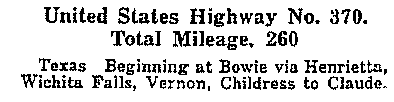
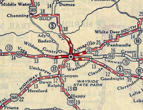
The specific endpoint of US 366 in Amarillo will be discussed below. But first, note the map above also showed a fourth route: US 370, coming northwestward from Wichita Falls. US 66 heading west was shown with a broad curve to the southwest, meeting US 370 at a point southeast of Amarillo. That junction was not labeled on the map, but the 1927 route log specified that the location was Claude:
c. 1927, AASHO
|
On the map above, the road heading southeast from Amarillo to [the unnamed junction which we will presume for now to be Claude] is today's US 287. The curving segment of US 66 heading northeast from its junction with US 370 was, um... completely fictional. Well, maybe not completely: it did exist on paper, but only in the form of proposals and plans. Among the many things I have learned from the research of Jim Ross and Jerry McClanahan is: that diagonal was proposed along the right-of-way for a railroad grade. But that railroad was never built, nor was an auto road built to follow its corridor. Furthermore: even if that road had been built, its junction with US 66 would not have been in Claude. Already by Feb. 1927, when AASHO asked TXDoT to review their maps and route logs for accuracy, Texas responded with the following correction:

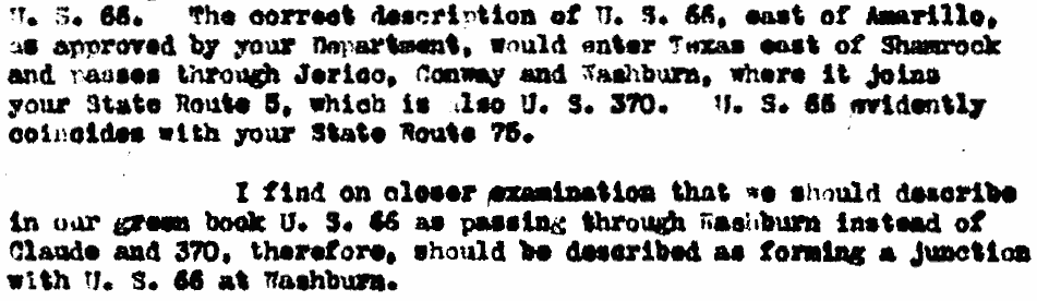
Did this junction located "northwest of Claude" have a name? And how many miles is "a few"? Since TXDoT did not specify those details, AASHO continued to use "Claude" as its control point. It wasn't until 1930 that AASHO finally clued in that the US 66 - US 370 junction was not in Claude, but rather in Washburn. Correspondence indicates they were made aware of this detail not by TXDoT, but instead by a third-party commercial cartographer. In April of that year, upon realizing this distinction, AASHO sent a letter to TXDoT; below is an excerpt:
|
To summarize so far: the US 66-370 junction that was shown on early maps would have actually been in Washburn, not Claude. And the curving diagonal segment of US 66 didn't really exist, but instead US 66 traffic must have used section-line roads to stair-step its way between Washburn and Conway... right? As illustrated on this map?
|
c. 1928, Gallup
|
(Incidentally, US 164 made its first appearance on that map, but we will address that later). Actually, the map above was not accurate either. Why? Because US 66 traffic was never directed to dip down to the south to pass through Washburn. Rather, it always went directly east-west between Amarillo and Conway...
|
...and that means US 370 never terminated in Washburn, but rather extended all the way into Amarillo. In Nov. 1930, TXDoT wrote to AASHO with a correction that the west end of US 370 should be described as Amarillo instead of Washburn...
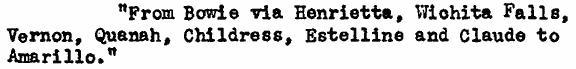
...but in AASHO's response it was noted that the "little green book" (route log) that they had published the previous year already included each of those towns. This 1927 map had it essentially correct:
|
c. 1927, Rand McNally
|
|
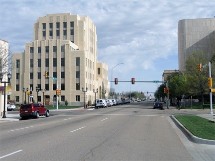
Before continuing on about this Amarillo-Claude-Washburn controversy, I will pause here to show photos of the actual terminus point in Amarillo (since that is what most visitors to this page are probably looking for anyway), and then I will forge ahead with more verbosity about the early routing of US 66. This photo was looking west on South 6th Av:
|
Sanderson, Mar. 2012
|
|
It was unclear to me why there was a US 66 sign in that particular location (it has since been replaced with the more common brown version), because US 66 never used 6th east of Fillmore. But then it was explained to me that people following westbound Historic 66 today cannot use Fillmore since it is one-way northbound. So instead drivers are directed to follow Pierce St. south, then 6th west... so that was a reassurance marker for them. Anyway, straight ahead (on the other side of Fillmore) was the original westbound US 66. Eastbound was to the right on Fillmore. Also to the right was the west beginning of US 164 from 1928 to 1930, and the west beginning of US 60 from 1930 to 1931. To the left was the north beginning of US 366 from 1926 to 1931, and the west beginning of US 370 until 1939. This photo was taken looking north on Fillmore:
|
Sanderson, Mar. 2012
|
|
Today that is one-way northbound, but originally Fillmore was a two-way street, and it carried both directions of US 385. Westbound US 66 was to the left on 6th, while eastbound was straight ahead. Also straight ahead was the west beginning of US 164 (and later, US 60). So that photo shows what would have been the perspective of a driver at the north end of US 366, and at the west end of US 370. Next, we are looking the opposite direction (south on Fillmore):
|
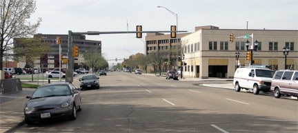
Sanderson, Mar. 2012
|
That was westbound US 66 (which continued to the right on 6th), and southbound US 385 (which continued straight ahead). Also straight ahead was the beginning of US 366 and US 370. That photo shows the perspective of a driver at the historic west end of US 164, and later at the end of US 60.
US 66 never went through Washburn
Back to the controversy, you might be thinking, "Wait a minute, there are lots of other maps that show US 66 dropping to the south to join US 370 somewhere southeast of Amarillo." Yes, I am aware of those maps (in fact, many of them are displayed at the bottom of this page). But those maps reflected a planned route that never came to fruition. They did not illustrate the actual routing in the field. (In my opinion, this makes the 1927 RMN map [shown above] remarkable for being the only early map to illustrate the actual conditions... which in turn leads me to speculate that RMN might have been the only company to actually field-check their map, rather than relying solely on source material from AASHO and/or TXDOT.)
"Not so fast", you might counter. "How can you discount all the written material (shown above) from both AASHO and TXDOT?" From what I can tell, when TXDOT referred to US 66, they were actually referring to the unbuilt routing that they had approved and were planning to construct. But it seems they were not transparent about that with AASHO, and for that reason AASHO was initially not aware that US 66 did not actually go through Washburn.
How do we know this? Again, I am indebted to the research of Ross and McClanahan, who provided me with the following newspaper articles from the Amarillo Globe-Times. This first one, from April 1928, implied that the then-existing route of US 66 came into town via North Fillmore:
"Not so fast", you might counter. "How can you discount all the written material (shown above) from both AASHO and TXDOT?" From what I can tell, when TXDOT referred to US 66, they were actually referring to the unbuilt routing that they had approved and were planning to construct. But it seems they were not transparent about that with AASHO, and for that reason AASHO was initially not aware that US 66 did not actually go through Washburn.
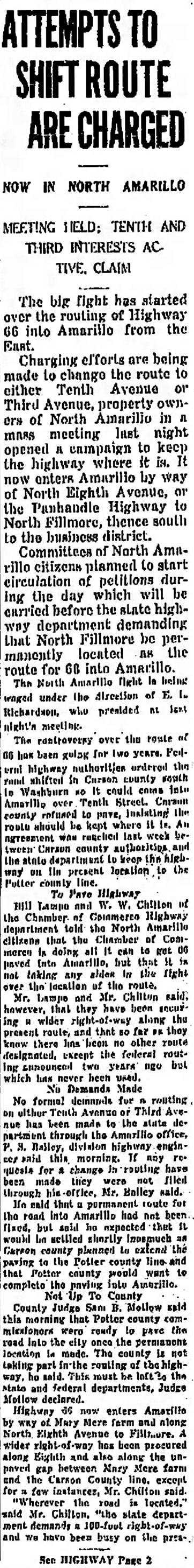
How do we know this? Again, I am indebted to the research of Ross and McClanahan, who provided me with the following newspaper articles from the Amarillo Globe-Times. This first one, from April 1928, implied that the then-existing route of US 66 came into town via North Fillmore:
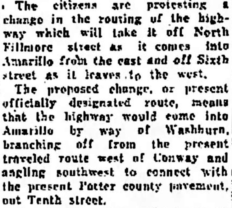
US 66 would not have used North Fillmore if traffic had been coming in from Washburn. Note also the statement that "the proposed change... means that the highway would come into Amarillo by way of Washburn..." This next clipping is from Sep. 1930; note that the second paragraph states that the then-existing route was still using North 8th and North Fillmore:
|
Other noteworthy snippets from there:
So the bottom line is: US 66 traffic always followed a straight line essentially due east out of Amarillo. Maps that showed US 66 dropping to a point southeast of Amarillo were illustrating a planned-but-never-implemented alignment. And route logs that described US 66 as passing through Washburn were actually describing this proposed alignment. Now, back to the history of other US routes in Amarillo: US 164 was not among the inaugural routes of Nov. 1926, but it was one of the first routes to be commissioned after that initial batch. The following excerpt is from a June 1927 letter from AASHO to TXDoT: 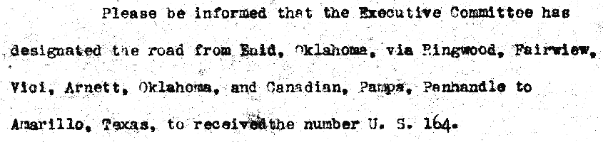
As a result, US 164 was already shown on 1928 maps. But maps from 1930 were the last to show US 164, because that was the year the US 60 designation was extended west from Missouri. The westernmost segment of that extension was along what had been US 164, so that designation was absorbed in its entirety (from Amarillo to Enid OK). That change was illustrated on this map:
c. 1931? TXDoT
Another important change was also shown on that map: whereas previously US 66 had been shown jogging southwest to join US 370 at Washburn, it was now shown correctly, jogging slightly northwest to join US 60 just east of Amarillo. However, not all cartographers immediately picked up on that distinction; this map from a couple years later still showed US 66 passing through Washburn:
c. 1932, US Bureau of Public Roads (linked to source)
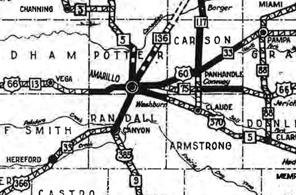
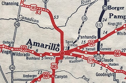
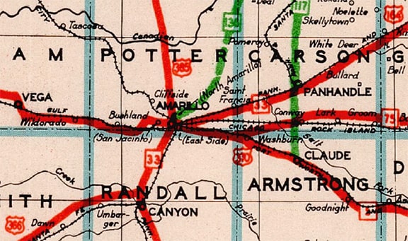
On the other hand, that map did accurately portray the 1932 extension of US 60, which absorbed the former US 366 heading southwest from Amarillo. By contrast, even a TXDoT map from the following year (1933) showed US 60 along that route, but also showed US 366 concurrent with it. Also note this cartographer was very intentional about denoting the US 366-385 overlap between Amarillo and Canyon:
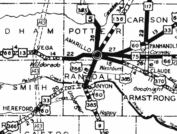
c. 1933, TXDoT
c. 1933, TXDoT
c. 1934, Gallup
|
Now that we have a good overview of the early changes that took place in the US route system around Amarillo, we will move on to the specific routings of those highways through the city. Again, US 385 ran along Fillmore Street. US 66 also used Fillmore, but only along the one-mile segment between North 8th Avenue and South 6th Avenue. US 66 heading west out of town used S. 6th, and N. 8th (now Amarillo Boulevard) was the routing for eastbound US 66 traffic.
US 366 approached Amarillo from the south, overlapped with US 385. As for US 370: despite early route logs and maps indicating its west endpoint was at Claude, we have established its junction with US 66 was actually in Amarillo. Traffic would have come into town on South 10th Avenue. So US 370 and US 366 joined at the intersection of Fillmore and S. 10th, meaning it is possible that one of the designations could have ended there, or both routes could have shared a common terminus there. But based on signage practices that were common at the time (especially in Texas), I think it is far more likely that the three routes (385, 370, and 366) were overlapped north on Fillmore, with both US 366 and US 370 sharing a common terminus at S. 6th (junction US 66).
In 1928, US 164 was commissioned to serve traffic coming into Amarillo from the northeast. US 164 arrived via today's US 60, so the designation could have ended at its junction with US 66 (at or near the junction of today's Amarillo Blvd and Triangle Drive), or where US 66-164 met US 385 (Amarillo Blvd at Fillmore). However (this theme should be familiar by now) it is more likely that US 164 would have been co-signed with US 66-385 down Fillmore to the main highway junction at the center of town... in other words, the same endpoint as US 366 and US 370 (which causes one to wonder why US 164 was not numbered as a northeastward extension of US 366 instead).
|
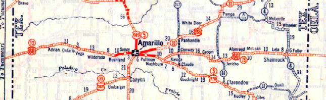
By the late 1920s, Amarillo was served by those five US routes, which led out of the city in five different directions, and which branched out to seven within a 16-mile radius. But as soon as 1930 rolled around, the route numbers began to change, and by the end of that decade, four of them were history. First, US 60 was extended westward from Missouri to Amarillo. The westernmost segment of this extension was along what had been US 164, so that was the first of Amarillo's route numbers to be retired. US 60 would have had the same endpoint as US 164 for a year or two (Fillmore at S. 6th). In 1932 US 60 was extended again: this time westward out of Amarillo... and since that extension was along US 366, it brought about the demise of that route. Then in about 1935, US 385 was replaced by a southern extension of US 87. That was the arrangement illustrated on the following map (which unfortunately is the earliest detailed map of Amarillo that I have found thus far):
|
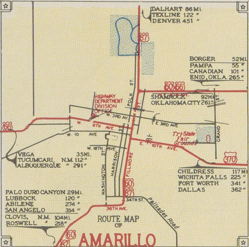
c. 1938, TXDoT
|
The year after that map (1939) a southeastward-expanding US 287 eliminated the US 370 designation. And the fifth (and final) US route to be removed from Amarillo was US 66, which was decommissioned in 1985. What this means is: every one of the seven original US routes that branched out of Amarillo in the 1920s has been renumbered.
So, to reiterate: while it is possible that some routes ended at Fillmore north of downtown (on N. 8th, or Amarillo Blvd) and others may have ended to the south (on S. 10th), it is more likely that all four of them would have been signed to the central highway junction (at S. 6th).
So, to reiterate: while it is possible that some routes ended at Fillmore north of downtown (on N. 8th, or Amarillo Blvd) and others may have ended to the south (on S. 10th), it is more likely that all four of them would have been signed to the central highway junction (at S. 6th).
|
The remainder of this page shows some additional discrepancies on other early maps. For example, this one showed US 66 following the same non-existent curve to the southwest as the AASHO map shown above. US 370 was shown to join US 66 at an unlabeled junction northwest of Claude. However, instead of ending at that junction, US 370 was shown to piggyback with US 66 to Amarillo and end there:
|
c. 1927, National Map Company
|
|
As the story was told by another 1927 map, US 66 did not go through Groom or Conway at all, because it instead followed a diagonal route (also completely fabricated) from Jericho to Goodnight, where it met US 370 east of Claude:
|

c. 1927, Clasons
|
|
These next two examples continued to exhibit the sweeping curve in US 66 between Washburn and Conway, and they also illustrated the addition of US 164[i], a new designation coming into Amarillo from the northeast:
|
c. 1928
|
c. 1928, Clasons
|
|
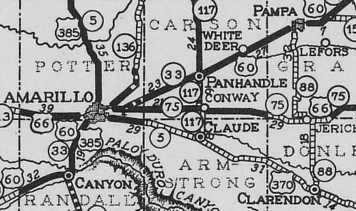
TXDoT's official state highway map of 1930 showed that not much had changed since 1928: US 164 was still shown heading northeast from Amarillo, and the US 66-370 junction was still at Washburn. However, this map included a fictitious diagonal road between Washburn and Conway:
|
c. 1930, TXDoT
|
|
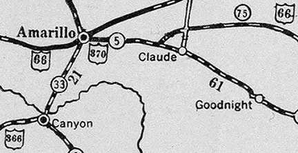
This 1930 map also showed the diagonal between Washburn and Conway, but it suggested that US 66 did not use the diagonal, instead following the north-south highway between Conway and Claude:
|

c. 1930, Clasons
|
Research and/or photo credits: William Bacon; Robert Droz; Nathan Edgars; Jerry McClanahan; Mike Roberson; Jim Ross; Dale Sanderson
Page originally created 2006;
last updated May 8, 2024.
last updated May 8, 2024.
