US Ends .com
  • Home
  • Store
    • US highway map
    • Florida US highway map
  • Endpoints
    • US 1 - US 9 >
      • 1 >
        • 201
        • 301
        • 401 [i]
        • 401 [ii]
        • 401
        • 501
        • 601
        • 701
      • 2w >
        • 102
      • 2e >
        • 202
        • 302
      • 3
      • 4 >
        • 104
      • 5
      • 6 >
        • 106
        • 206
      • 7
      • 8
      • 9 >
        • 109*
        • 209
        • 309
    • US 10 - US 19 >
      • 10 >
        • 110
        • 210
        • 310
        • 410
      • 11 >
        • 111
        • 211
        • 311
        • 411 [i]
        • 411 [ii]
        • 411
        • 511*
        • 611
        • 711*
      • 12 >
        • 112
        • 212
        • 312
      • 13 >
        • 113
        • 213
      • 14
      • 15
      • 16 >
        • 116
        • 216
      • 17 >
        • 17-1
        • 117 [i]
        • 117
        • 217
      • 18 >
        • 118
        • 218
      • 19 >
        • 119
        • 219
        • 319
    • US 20 - US 29 >
      • 20 >
        • 120
        • 220
        • 320
        • 420
      • 21 >
        • 121 [i]
        • 121
        • 221
        • 321
        • 421
        • 521
      • 22 >
        • 122 [i]
        • 122 [ii]
        • 222
        • 322
        • 422e
        • 422w
        • 522
        • 622*
      • 23 >
        • 123 [i]
        • 123
        • 223
      • 24 >
        • 124
        • 224
      • 25
      • 26 >
        • 126
      • 27 >
        • 127
        • 227
      • 28
      • 29 >
        • 129
    • US 30 - US 39 >
      • 30 >
        • 130
        • 230
        • 330
        • 430
        • 530
        • 630*
        • 730
        • 830
      • 31 >
        • 131
        • 231
        • 331 [i]
        • 331
        • 431
      • 32
      • 33
      • 34
      • 35
      • 36 >
        • 136
      • 38 >
        • 138
    • US 40 - US 49 >
      • 40 >
        • 140
        • 240
        • 340
      • 41 >
        • 141
        • 241 [i]
        • 241 [ii]
        • 341
        • 441
        • 541
        • 641
      • 42
      • 43
      • 44
      • 45
      • 46
      • 48 [i]
      • 48 [ii]
      • 48
      • 49
    • US 50 - US 59 >
      • 50 >
        • 150
        • 250
        • 350
        • 450
        • 550
        • 650
      • 51 - 55 >
        • 51 >
          • 151
        • 52 >
          • 152
        • 53
        • 54 >
          • 154
        • 55
      • 56 >
        • 156
      • 57
      • 58 >
        • 158
        • 258
      • 59 >
        • 159
        • 259
    • US 60 - US 69 >
      • 60 >
        • 160
        • 260
        • 360
        • 460
      • 61 - 65 >
        • 61 >
          • 161
        • 62
        • 63 >
          • 163 [i]
        • 64 >
          • 164 [i]
          • 164 [ii]
          • 264
        • 65 >
          • 165
      • 66 >
        • 166
        • 266
        • 366 [i]
        • 366 [ii]
        • 466
        • 566
        • 666
      • 67 >
        • 167
      • 68 >
        • 168
      • 69 >
        • 169
    • US 70 - US 79 >
      • 70 >
        • 170
        • 270 [i]*
        • 270
        • 370
        • 470
      • 71 >
        • 171
        • 271
        • 371 [i]
        • 371
      • 72 - 76 >
        • 72
        • 73
        • 74
        • 75 >
          • 175
          • 275
        • 76 >
          • 176
          • 276
      • 77 >
        • 177
        • 277
        • 377
      • 78 >
        • 178
        • 278
        • 378
      • 79
    • US 80 - US 89 >
      • 80 - 84 >
        • 80 >
          • 180 [i]
          • 180
          • 280
          • 380
        • 81 >
          • 181
          • 281
        • 82
        • 83 >
          • 183
          • 283
          • 383
        • 84
      • 85 - 89 >
        • 85 >
          • 185
          • 285 [i]
          • 285
          • 385 [i]
          • 385
          • 485
        • 87 >
          • 187
          • 287
        • 89 >
          • 189 [i]
          • 189
    • US 90 - US 99 >
      • 90 - 94 >
        • 90 >
          • 190
          • 290
        • 91 >
          • 191
          • 491
        • 92 >
          • 192
        • 93
        • 94
      • 95 -98 >
        • 95 >
          • 195
          • 295
          • 395
        • 96 [i]
        • 96
        • 97 >
          • 197
        • 98
      • 99 >
        • 199
        • 299
        • 399
    • Anomalies >
      • 101
      • 163
      • 400
      • 412
      • 425
  • Places
    • A-L >
      • A >
        • Aberdeen
        • Albuquerque
        • Amarillo
        • Apalachicola
        • Astoria
        • Atlantic
      • B >
        • Baltimore
        • Baton Rouge
        • Bay Area
        • Bishop
        • Boone
        • Brady
        • Bristol
        • Brownsville
        • Brunswick
      • C >
        • Charleston
        • Chattanooga
        • Chicago
        • Cincinnati
        • Cleveland
        • Cody
        • Corpus
        • Cortez
        • Council Bluffs
        • Covington
        • Crescent
        • Cumberland Gap
      • D-E >
        • Dallas
        • Des Moines
        • Detroit
        • Dothan
        • Douglas
        • El Paso
        • Eugene
        • Erie
      • F >
        • Farmington
        • Flagstaff
        • Florence
        • Fox Valley
        • Franklin
      • G >
        • Gallup
        • Grand Junction
        • Grand Portage
        • Grayling
        • Great Falls
        • Greeley
      • H-I >
        • Hardeeville
        • Harrisburg
        • Holbrook
        • Idaho Falls
        • Int'l Falls
      • J-K >
        • Jacksonville
        • Joplin
        • Junction
        • Kansas City
        • Keokuk
        • Key West
        • Kingman
      • L >
        • Laredo
        • Lewiston
        • Long Beach
        • Los Angeles
        • Louisville
        • Lubbock
    • M-R >
      • M >
        • Mackinaw
        • Madison
        • Maryhill
        • Maysville
        • Miami
        • Midway
        • Miles City
        • Milford
        • Milwaukee
        • Minneapolis
        • Mobile 31
        • Mobile 31-43-45
        • Montgomery
        • Monticello
        • Mount Vernon
      • N-O >
        • Nags Head
        • Naples
        • Natchez
        • New Castle
        • New Orleans
        • Niagara
        • Norlina
        • Ocean City
        • Oklahoma City
      • P >
        • Pee Dee
        • Pembina
        • Pensacola
        • Petersburg
        • Philadelphia
        • Piegan
        • Pineville
        • Port Arthur
        • Portsmouth
      • Q-R >
        • Quad Cities
        • Rapid City
        • Raton
        • Reading
        • Richmond
        • Rockingham
        • Rouses Point
    • S-Z >
      • S >
        • San Antonio
        • San Antonio NM
        • San Diego
        • Santa Fe
        • Savannah
        • Sioux
        • Springer
        • Springfield
        • St. Ignace
        • St. John
        • St. Paul
        • St. Pete
      • T-U-V >
        • Tallahassee
        • Tampa
        • Toledo
        • Trinidad
        • Ucolo
        • VA Beach
      • W >
        • Walterboro
        • Waverly
        • West Memphis
        • Wilmington
        • Wilson
        • Wrightsville
      • Y >
        • Yellowstone E
        • Yellowstone N
        • Yellowstone NE
        • Yellowstone S
        • Yellowstone W
  • Highways
    • Map of all endpoints
    • Sources
    • History
    • 1926 almost-routes
    • Intra-state routes
    • Numbering
    • Colors
    • Blog
  • Bonus
    • Colorado >
      • Lowest point
      • Antipodes
      • Toponymy >
        • Roots
      • Colloquialisms
      • Populations
      • Denvers
    • Washington Meridian
    • Watersheds >
      • Headwaters Hill
      • Three Waters Mtn.
      • Parting of the Waters
    • Geo-centers >
      • 48 states
      • 50 states
      • North America
    • State corners >
      • AZ-CO-NM-UT
      • CO-UT-WY
      • CO-NE-WY
      • CO northeast
      • CO-KS-NE
      • CO-KS-OK
      • CO-NM-OK
      • NM-OK-TX
      • NM southeast
      • TX northwest
    • ooss.space
  • Connect
    • Author/history
    • Rationale
    • Contact
    • Contributors
    • Submissions

US 522

End of US highway 522

View a map showing this route.
Get your very own map showing all current and historic US routes!
Picture
Summa
Picture
Summa
1926-1927
  • North: Selinsgrove, PA
  • South: Lewistown, PA
1927-1944
  • North: Selinsgrove, PA
  • South: Hancock, MD
1944-present
  • North: Selinsgrove, PA
  • South: Powhatan, VA
Mileage: in 1989 AASHTO listed a figure of 310 miles for US 522... however, that included the mileage of US 522's associated business route.  According to the state subtotals on AASHTO's 1989 spreadsheet, mainline US 522's actual end-to-end total at the time was 308 miles.  That closely matches our own 2020 measurement, which yielded 307.8 miles.

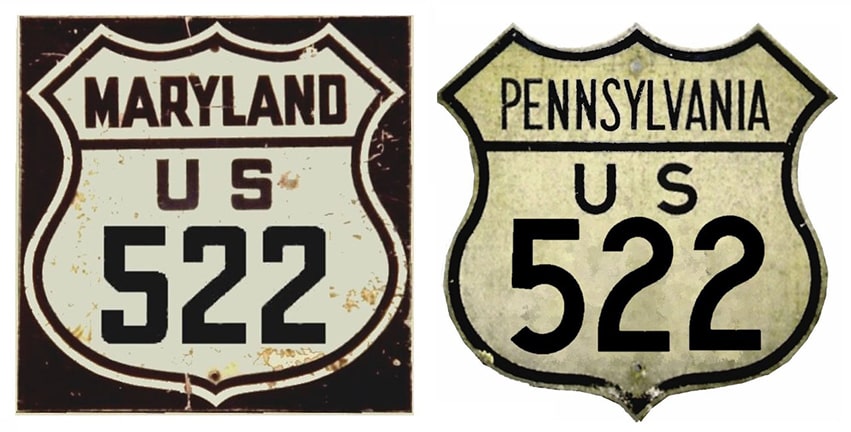
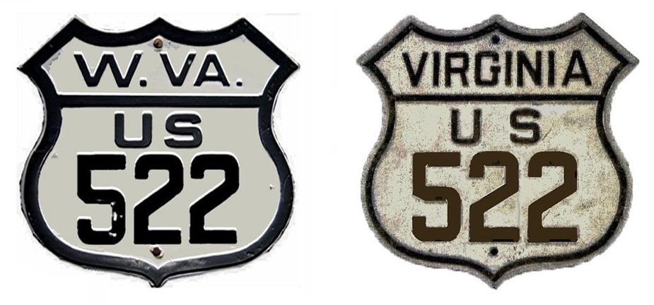
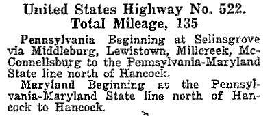
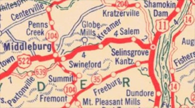
US 522 was an original 1926 route, although the AASHO map that was approved that year showed it only between Selinsgrove and Lewistown.  The remainder of its route to Maryland was shown as "US 622" (more on this page).  However, by the time of AASHO's 1927 route log, US 622 was no longer listed, and US 522 was shown along the entire route between Hancock and Selinsgrove:  ​
Picture
Picture
c. 1930, PennDoT
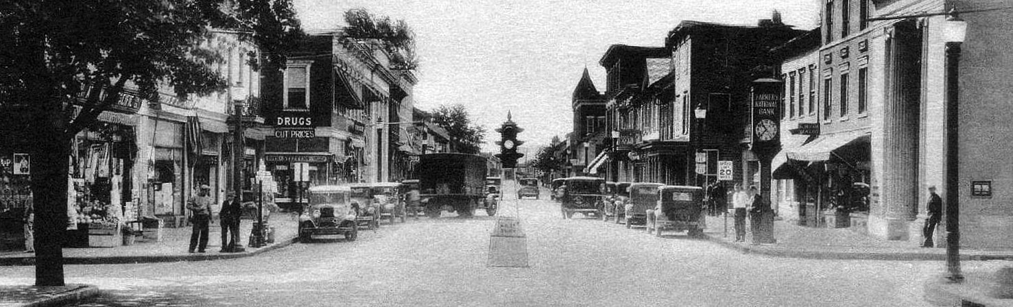
Traffic originally came into town via University Avenue, and the north end of US 522 was on Pine Street at its intersection with Market Street.  This image was taken looking south on Market:
Picture
Fasold, c. 1935 (linked to original image)
The north beginning of US 522 was to the right on Pine.  Two US route shields are barely visible on the right-hand side of Market; they were for US 11 and US 111.  But it wasn't long before the US 15 designation was extended along the former US 111.  Then those same confirming markers looked like this:
Picture
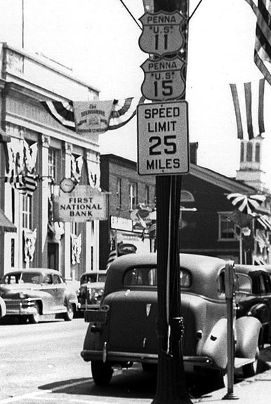
Fasold, Aug. 1953 (linked to original image)
Four years prior to that photo (1949) modern US 522 opened to traffic -- this road runs along the north edge of Selinsgrove.  At that time, US 522 still ended at Market.  That was no longer the case at the time of this photo, but it does show the historic terminus.  This was taken looking east on US 522:
Picture
Reichard, Oct. 2001
Picture
(detail)
In 1949, US 522 ended there; southbound US 11-15 was to the right, and northbound was to the left...

...but in 1976, US 11-15 was routed onto a bypass that skirts the east side of Selinsgrove.  So the US 522 designation was extended north along former US 11-15 to its current terminus: a partial interchange with the new US 11-15, which is about a half-mile to the left.  The view in this photo was heading south towards Selinsgrove on US 11-15:
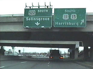
Picture
Nitzman, 1994
Formerly US 11-15 continued straight ahead on Market through downtown, and the north terminus of US 522 was about a half-mile ahead.  But now US 11-15 exits right, loops around to the left via the overpass, and then continues south again along a newer bypass off to the east.  So today US 522 begins straight ahead.  It follows Market to the intersection shown in the first photo, then turns right.  ​
While US 522 does start out heading essentially west, it soon begins a gradual curve to the south, mimicking the bend of the Appalachian Mountains... which suggests that it should have been numbered differently, as a branch of a north/south route.  For example, an "x11" or "x15" number might have been more appropriate.  ​The original south end of US 522 was at Hancock:
Picture
c. 1930, PennDoT
There, the original route of US 522 (Warfordsburg Road) has been interrupted by I-70, but that aligns with Limestone Road on the south side of the freeway.  So presumably US 522 ran along Limestone and ended where that junctions Main Street:
Picture
Mortell, Aug. 2007
The sign assembly indicates that Main is now MD hwy. 144, but it carried US 40 traffic until I-70 was built.  Here, we are looking west on Main:
Picture
Mortell, Aug. 2007
That was westbound US 40, which curved to the left.  To the right on Limestone was probably the south beginning of US 522.  
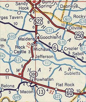
​In 1944, US 522 was extended south from Hancock -- the bridge visible in that last photo carries US 522 traffic over the Potomac River and into West Virginia.  Since then, the south end of US 522 has been at its current terminus, which is at its junction with US 60 in Powhatan:
Picture
c. 1956, Gousha
 These photos were taken heading south on US 522, showing the approach to the endpoint and the actual intersection where US 522 ends:
Picture
Robb, Mar. 2004
Picture
Robb, Mar. 2004
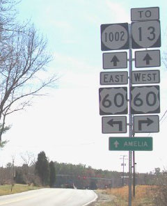
Incidentally: prior to the mid-1930s, that segment of US 60 had not been built.  Instead it followed what is now VA hwy. 13, which is about 1/4-mile ahead.  But by the time US 522 was extended down to Powhatan, that "newer" US 60 was already there.  Here, we are looking the opposite direction -- US 522 begins straight ahead:
Picture
Robb, Mar. 2004
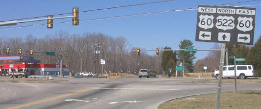
The green sign on the opposite side of the intersection gave mileage to a few cities and included a US 522 shield on the top:
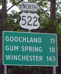
Picture
Sweeney, May 2020
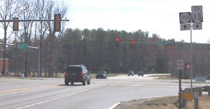
​Next is the south beginning of US 522 as seen from US 60 (both​ eastbound and westbound, respectively):
Picture
Robb, Mar. 2004
Picture
Robb, Mar. 2004

Research and/or photo credits: Charles Fasold; Robert Mortell; Alex Nitzman; Tim Reichard; Bob Robb; Dale Sanderson; Michael Summa; Collin Sweeney; L.E. Tuttle
Page originally created 2000;
last updated Nov. 28, 2021.
Copyright © 1998-2023
Picture