US Ends .com
  • Home
  • Store
    • US highway book
    • US highway map
    • Florida US highway map
  • Endpoints
    • US 1 - US 9 >
      • 1 >
        • 201
        • 301
        • 401 [i]
        • 401 [ii]
        • 401
        • 501
        • 601
        • 701
      • 2w >
        • 102
      • 2e >
        • 202
        • 302
      • 3
      • 4 >
        • 104
      • 5
      • 6 >
        • 106
        • 206
      • 7
      • 8
      • 9 >
        • 109*
        • 209
        • 309
    • US 10 - US 19 >
      • 10 >
        • 110
        • 210
        • 310
        • 410
      • 11 >
        • 111
        • 211
        • 311
        • 411 [i]
        • 411 [ii]
        • 411
        • 511*
        • 611
        • 711*
      • 12 >
        • 112
        • 212
        • 312
      • 13 >
        • 113
        • 213
      • 14
      • 15
      • 16 >
        • 116
        • 216
      • 17 >
        • 17-1
        • 117 [i]
        • 117
        • 217
      • 18 >
        • 118
        • 218
      • 19 >
        • 119
        • 219
        • 319
    • US 20 - US 29 >
      • 20e >
        • 120
        • 220
        • 320
        • 420
      • 20w
      • 21 >
        • 121 [i]
        • 121
        • 221
        • 321
        • 421
        • 521
      • 22 >
        • 122 [i]
        • 122 [ii]
        • 222
        • 322
        • 422e
        • 422w
        • 522
        • 622*
      • 23 >
        • 123 [i]
        • 123
        • 223
      • 24 >
        • 124
        • 224
      • 25
      • 26 >
        • 126
      • 27 >
        • 127
        • 227
      • 28
      • 29 >
        • 129
    • US 30 - US 39 >
      • 30 >
        • 130
        • 230
        • 330
        • 430
        • 530
        • 630*
        • 730
        • 830
      • 31 >
        • 131
        • 231
        • 331 [i]
        • 331
        • 431
      • 32
      • 33
      • 34
      • 35
      • 36 >
        • 136
      • 38 >
        • 138
    • US 40 - US 49 >
      • 40 >
        • 140
        • 240
        • 340
      • 41 >
        • 141
        • 241 [i]
        • 241 [ii]
        • 341
        • 441 >
          • 441n
          • 441s
        • 541
        • 641
      • 42
      • 43
      • 44
      • 45
      • 46
      • 48 [i]
      • 48 [ii]
      • 48
      • 49
    • US 50 - US 59 >
      • 50 >
        • 150
        • 250
        • 350
        • 450
        • 550
        • 650
      • 51 - 55 >
        • 51 >
          • 151
        • 52 >
          • 152
        • 53
        • 54 >
          • 154
        • 55
      • 56 >
        • 156
      • 57
      • 58 >
        • 158
        • 258
      • 59 >
        • 159
        • 259
    • US 60 - US 69 >
      • 60 >
        • 160
        • 260
        • 360
        • 460
      • 61 - 65 >
        • 61 >
          • 161
        • 62
        • 63 >
          • 163 [i]
        • 64 >
          • 164 [i]
          • 164 [ii]
          • 264
        • 65 >
          • 165
      • 66 >
        • 166
        • 266
        • 366 [i]
        • 366 [ii]
        • 466 [i]*
        • 466 [ii]
        • 566
        • 666
      • 67 >
        • 167
      • 68 >
        • 168
      • 69 >
        • 169
    • US 70 - US 79 >
      • 70 >
        • 170
        • 270 [i]*
        • 270
        • 370
        • 470
      • 71 >
        • 171
        • 271
        • 371 [i]
        • 371 [ii]
        • 371
      • 72 - 76 >
        • 72
        • 73
        • 74
        • 75 >
          • 175
          • 275
        • 76 >
          • 176
          • 276
      • 77 >
        • 177
        • 277
        • 377
      • 78 >
        • 178
        • 278
        • 378
      • 79
    • US 80 - US 89 >
      • 80 - 84 >
        • 80 >
          • 180 [i]
          • 180
          • 280
          • 380
        • 81 >
          • 181
          • 281
        • 82
        • 83 >
          • 183
          • 283
          • 383
        • 84
      • 85 - 89 >
        • 85 >
          • 185
          • 285 [i]
          • 285
          • 385 [i]
          • 385
          • 485
        • 87 >
          • 187
          • 287n
          • 287s
        • 89n
        • 89s >
          • 189 [i]
          • 189
    • US 90 - US 99 >
      • 90 - 94 >
        • 90 >
          • 190
          • 290
        • 91 >
          • 191 >
            • 191n
            • 191s
          • 491
        • 92 >
          • 192
        • 93
        • 94
      • 95 -98 >
        • 95 >
          • 195
          • 295
          • 395
        • 96 [i]
        • 96
        • 97 >
          • 197
        • 98
      • 99 >
        • 199
        • 299
        • 399
    • Anomalies >
      • 101
      • 163
      • 400
      • 412
      • 425
  • Places
    • A-L >
      • A >
        • Aberdeen
        • Albuquerque
        • Amarillo
        • Apalachicola
        • Astoria
        • Atlantic
      • B >
        • Baltimore
        • Baton Rouge
        • Bay Area
        • Bishop
        • Boone
        • Brady
        • Bristol
        • Brownsville
        • Brunswick
      • C >
        • Charleston
        • Chattanooga
        • Chicago
        • Cincinnati
        • Cleveland
        • Cody
        • Corpus
        • Cortez
        • Council Bluffs
        • Covington
        • Crescent
        • Cumberland Gap
      • D-E >
        • Dallas
        • Des Moines
        • Detroit
        • Dothan
        • Douglas
        • El Paso
        • Erie
        • Eugene
      • F >
        • Farmington
        • Flagstaff
        • Florence
        • Fox Valley
        • Franklin
      • G >
        • Gallup
        • Georgetown
        • Grand Junction
        • Grand Portage
        • Grayling
        • Great Falls
        • Greeley
      • H-I >
        • Hardeeville
        • Harrisburg
        • Holbrook
        • Idaho Falls
        • Int'l Falls
      • J-K >
        • Jacksonville
        • Joplin
        • Junction
        • Kansas City
        • Keokuk
        • Key West
        • Kingman
      • L >
        • Laredo
        • Lewiston
        • Long Beach
        • Los Angeles
        • Louisville
        • Lubbock
    • M-R >
      • M >
        • Mackinaw
        • Madison
        • Maryhill
        • Maysville
        • Miami
        • Midway
        • Miles City
        • Milford
        • Milwaukee
        • Minneapolis
        • Mobile 31
        • Mobile 31-43-45
        • Montgomery
        • Monticello
        • Mount Vernon
      • N-O >
        • Nags Head
        • Naples
        • Natchez
        • New Castle
        • New Orleans
        • Niagara
        • Norlina
        • Ocean City
        • Oklahoma City
      • P >
        • Pee Dee
        • Pembina
        • Pensacola
        • Petersburg
        • Philadelphia
        • Piegan
        • Pineville
        • Port Arthur
        • Portsmouth
      • Q-R >
        • Quad Cities
        • Rapid City
        • Raton
        • Reading
        • Richmond
        • Rockingham
        • Rouses Point
    • S-Z >
      • S >
        • San Antonio
        • San Antonio NM
        • San Diego
        • Santa Fe
        • Savannah
        • Sioux
        • Springer
        • Springfield
        • St. Ignace
        • St. John
        • St. Paul
        • St. Pete
      • T-U-V >
        • Tallahassee
        • Tampa
        • Toledo
        • Trinidad
        • Tuba City
        • Ucolo
        • VA Beach
      • W >
        • Walterboro
        • Waverly
        • West Memphis
        • Wilmington
        • Wilson
        • Wrightsville
      • Y >
        • Yellowstone E
        • Yellowstone N
        • Yellowstone NE
        • Yellowstone S
        • Yellowstone W
  • Highways
    • Map of all endpoints
    • Sources
    • History
    • 1926 almost-routes
    • Intra-state routes
    • Numbering
    • Colors
    • Gaps
    • Blog
  • Bonus
    • Colorado >
      • Lowest point
      • Antipodes
      • Toponymy >
        • Roots
      • Colloquialisms
      • Populations
      • Denvers
    • Washington Meridian
    • Watersheds >
      • Headwaters Hill
      • Three Waters Mtn.
      • Parting of the Waters
    • Geo-centers >
      • 48 states
      • 50 states
      • North America
    • State corners >
      • AZ-CO-NM-UT
      • CO-UT-WY
      • CO-NE-WY
      • CO northeast
      • CO-KS-NE
      • CO-KS-OK
      • CO-NM-OK
      • NM-OK-TX
      • NM southeast
      • TX northwest
  • Connect
    • Author/history
    • Rationale
    • Contact
    • Contributors
    • Submissions

End of US highway 19

View a map showing this route.
Get your very own map showing all current and historic US routes!
Picture
Summa
Picture
Summa
1926-1930
  • North: Erie, PA
  • South: (incremental extensions)
1930-1954
  • North: Erie, PA
  • South: St. Petersburg, FL
1954-present
  • North: Erie, PA
  • South: Memphis, FL
Mileage: in 1989 AASHTO listed a figure of 1554 miles for US 19... however, that included the mileage of US 19's associated business/truck/alternate routes, plus the mileage of both US 19E and US 19W.  According to the state subtotals on AASHTO's 1989 spreadsheet, mainline US 19's actual end-to-end total at the time was 1386 miles (assuming US 19W, which is about 11 miles shorter than US 19E).  
That is reasonably close to our own 2020 measurement, which yielded 1365.7 miles (again assuming US 19W).  Want historic mileages?  Our handy reference book includes the mileages that were published in all 13 of AASHO/AASHTO's historic route logs (spanning the years 1927 to 1989).
Get your copy of this epic book that commemorates the first century of the US route system!

The north end of US 19 has always been in Erie, although the exact location has changed a few times since 1927.  During its nascent years, the south end of US 19 was continually in flux.  In the original plan, the route existed in two segments: one running from Erie to an intersection near Gauley Bridge WV -- and the other running from Bluff City TN to Lawrenceville GA.  Maps from the following year already showed these two segments joined.  By 1928 the south end of US 19 had been extended to Thomasville GA, and to Tallahassee FL the next year.
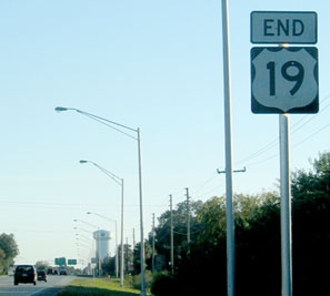
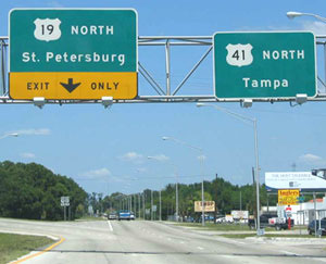
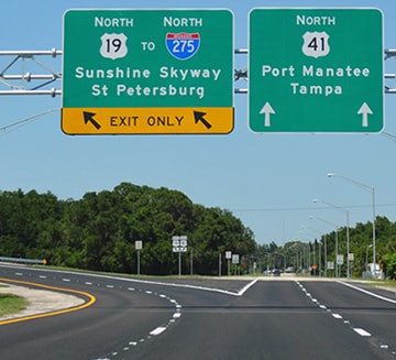
By 1930 US 19 had been extended down to St. Petersburg, where it remained for the next quarter-century.  ​In 1954 the Sunshine Skyway was built across Tampa Bay, and the US 19 designation was extended across the new bridge to its current terminus.  Today most people think of the Skyway as I-275, but US 19 continues to use the bridge as well.  At the first exit (Terra Ceia), US 19 is routed south for just a couple miles, ending at its junction with US 41 in Memphis (just north of Palmetto):
Picture
Buchanan/Nitzman, Dec. 2005
Picture
Buchanan/Ivy/Nitzman, Nov. 2016
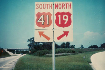
In that photo, traffic from US 41 merges in from the left.  These next photos show the south beginning of US 19 from the perspective of northbound US 41:
Picture
Cozart/Nitzman, Oct. 2006
Picture
Cozart, Apr. 2004
Picture
Ivy/Nitzman, May 2014
​Those panels were replaced in 2006 -- the shields look more standard now, but the signs are otherwise the same.  This next photo shows a similar assembly, although it was taken from the opposite direction (south on US 41), and this was back when Florida was still using colored US route shields:
Picture
Summa, 1975

Research and/or photo credits: Carter Buchanan; Justin Cozart; Brent Ivy; Alex Nitzman; Dale Sanderson; Michael Summa
Page originally created 1999;
last updated Oct. 23, 2021.
Copyright © 1998-2025
Picture