US Ends .com
  • Home
  • Store
    • US highway map
    • Florida US highway map
  • Endpoints
    • US 1 - US 9 >
      • 1 >
        • 201
        • 301
        • 401 [i]
        • 401 [ii]
        • 401
        • 501
        • 601
        • 701
      • 2w >
        • 102
      • 2e >
        • 202
        • 302
      • 3
      • 4 >
        • 104
      • 5
      • 6 >
        • 106
        • 206
      • 7
      • 8
      • 9 >
        • 109*
        • 209
        • 309
    • US 10 - US 19 >
      • 10 >
        • 110
        • 210
        • 310
        • 410
      • 11 >
        • 111
        • 211
        • 311
        • 411 [i]
        • 411 [ii]
        • 411
        • 511*
        • 611
        • 711*
      • 12 >
        • 112
        • 212
        • 312
      • 13 >
        • 113
        • 213
      • 14
      • 15
      • 16 >
        • 116
        • 216
      • 17 >
        • 17-1
        • 117 [i]
        • 117
        • 217
      • 18 >
        • 118
        • 218
      • 19 >
        • 119
        • 219
        • 319
    • US 20 - US 29 >
      • 20 >
        • 120
        • 220
        • 320
        • 420
      • 21 >
        • 121 [i]
        • 121
        • 221
        • 321
        • 421
        • 521
      • 22 >
        • 122 [i]
        • 122 [ii]
        • 222
        • 322
        • 422e
        • 422w
        • 522
        • 622*
      • 23 >
        • 123 [i]
        • 123
        • 223
      • 24 >
        • 124
        • 224
      • 25
      • 26 >
        • 126
      • 27 >
        • 127
        • 227
      • 28
      • 29 >
        • 129
    • US 30 - US 39 >
      • 30 >
        • 130
        • 230
        • 330
        • 430
        • 530
        • 630*
        • 730
        • 830
      • 31 >
        • 131
        • 231
        • 331 [i]
        • 331
        • 431
      • 32
      • 33
      • 34
      • 35
      • 36 >
        • 136
      • 38 >
        • 138
    • US 40 - US 49 >
      • 40 >
        • 140
        • 240
        • 340
      • 41 >
        • 141
        • 241 [i]
        • 241 [ii]
        • 341
        • 441
        • 541
        • 641
      • 42
      • 43
      • 44
      • 45
      • 46
      • 48 [i]
      • 48 [ii]
      • 48
      • 49
    • US 50 - US 59 >
      • 50 >
        • 150
        • 250
        • 350
        • 450
        • 550
        • 650
      • 51 - 55 >
        • 51 >
          • 151
        • 52 >
          • 152
        • 53
        • 54 >
          • 154
        • 55
      • 56 >
        • 156
      • 57
      • 58 >
        • 158
        • 258
      • 59 >
        • 159
        • 259
    • US 60 - US 69 >
      • 60 >
        • 160
        • 260
        • 360
        • 460
      • 61 - 65 >
        • 61 >
          • 161
        • 62
        • 63 >
          • 163 [i]
        • 64 >
          • 164 [i]
          • 164 [ii]
          • 264
        • 65 >
          • 165
      • 66 >
        • 166
        • 266
        • 366 [i]
        • 366 [ii]
        • 466
        • 566
        • 666
      • 67 >
        • 167
      • 68 >
        • 168
      • 69 >
        • 169
    • US 70 - US 79 >
      • 70 >
        • 170
        • 270 [i]*
        • 270
        • 370
        • 470
      • 71 >
        • 171
        • 271
        • 371 [i]
        • 371
      • 72 - 76 >
        • 72
        • 73
        • 74
        • 75 >
          • 175
          • 275
        • 76 >
          • 176
          • 276
      • 77 >
        • 177
        • 277
        • 377
      • 78 >
        • 178
        • 278
        • 378
      • 79
    • US 80 - US 89 >
      • 80 - 84 >
        • 80 >
          • 180 [i]
          • 180
          • 280
          • 380
        • 81 >
          • 181
          • 281
        • 82
        • 83 >
          • 183
          • 283
          • 383
        • 84
      • 85 - 89 >
        • 85 >
          • 185
          • 285 [i]
          • 285
          • 385 [i]
          • 385
          • 485
        • 87 >
          • 187
          • 287
        • 89 >
          • 189 [i]
          • 189
    • US 90 - US 99 >
      • 90 - 94 >
        • 90 >
          • 190
          • 290
        • 91 >
          • 191
          • 491
        • 92 >
          • 192
        • 93
        • 94
      • 95 -98 >
        • 95 >
          • 195
          • 295
          • 395
        • 96 [i]
        • 96
        • 97 >
          • 197
        • 98
      • 99 >
        • 199
        • 299
        • 399
    • Anomalies >
      • 101
      • 163
      • 400
      • 412
      • 425
  • Places
    • A-L >
      • A >
        • Aberdeen
        • Albuquerque
        • Amarillo
        • Apalachicola
        • Astoria
        • Atlantic
      • B >
        • Baltimore
        • Baton Rouge
        • Bay Area
        • Bishop
        • Boone
        • Brady
        • Bristol
        • Brownsville
        • Brunswick
      • C >
        • Charleston
        • Chattanooga
        • Chicago
        • Cincinnati
        • Cleveland
        • Cody
        • Corpus
        • Cortez
        • Council Bluffs
        • Covington
        • Crescent
        • Cumberland Gap
      • D-E >
        • Dallas
        • Des Moines
        • Detroit
        • Dothan
        • Douglas
        • El Paso
        • Eugene
        • Erie
      • F >
        • Farmington
        • Flagstaff
        • Florence
        • Fox Valley
        • Franklin
      • G >
        • Gallup
        • Grand Junction
        • Grand Portage
        • Grayling
        • Great Falls
        • Greeley
      • H-I >
        • Hardeeville
        • Harrisburg
        • Holbrook
        • Idaho Falls
        • Int'l Falls
      • J-K >
        • Jacksonville
        • Joplin
        • Junction
        • Kansas City
        • Keokuk
        • Key West
        • Kingman
      • L >
        • Laredo
        • Lewiston
        • Long Beach
        • Los Angeles
        • Louisville
        • Lubbock
    • M-R >
      • M >
        • Mackinaw
        • Madison
        • Maryhill
        • Maysville
        • Miami
        • Midway
        • Miles City
        • Milford
        • Milwaukee
        • Minneapolis
        • Mobile 31
        • Mobile 31-43-45
        • Montgomery
        • Monticello
        • Mount Vernon
      • N-O >
        • Nags Head
        • Naples
        • Natchez
        • New Castle
        • New Orleans
        • Niagara
        • Norlina
        • Ocean City
        • Oklahoma City
      • P >
        • Pee Dee
        • Pembina
        • Pensacola
        • Petersburg
        • Philadelphia
        • Piegan
        • Pineville
        • Port Arthur
        • Portsmouth
      • Q-R >
        • Quad Cities
        • Rapid City
        • Raton
        • Reading
        • Richmond
        • Rockingham
        • Rouses Point
    • S-Z >
      • S >
        • San Antonio
        • San Antonio NM
        • San Diego
        • Santa Fe
        • Savannah
        • Sioux
        • Springer
        • Springfield
        • St. Ignace
        • St. John
        • St. Paul
        • St. Pete
      • T-U-V >
        • Tallahassee
        • Tampa
        • Toledo
        • Trinidad
        • Ucolo
        • VA Beach
      • W >
        • Walterboro
        • Waverly
        • West Memphis
        • Wilmington
        • Wilson
        • Wrightsville
      • Y >
        • Yellowstone E
        • Yellowstone N
        • Yellowstone NE
        • Yellowstone S
        • Yellowstone W
  • Highways
    • Map of all endpoints
    • Sources
    • History
    • 1926 almost-routes
    • Intra-state routes
    • Numbering
    • Colors
    • Blog
  • Bonus
    • Colorado >
      • Lowest point
      • Antipodes
      • Toponymy >
        • Roots
      • Colloquialisms
      • Populations
      • Denvers
    • Washington Meridian
    • Watersheds >
      • Headwaters Hill
      • Three Waters Mtn.
      • Parting of the Waters
    • Geo-centers >
      • 48 states
      • 50 states
      • North America
    • State corners >
      • AZ-CO-NM-UT
      • CO-UT-WY
      • CO-NE-WY
      • CO northeast
      • CO-KS-NE
      • CO-KS-OK
      • CO-NM-OK
      • NM-OK-TX
      • NM southeast
      • TX northwest
    • ooss.space
  • Connect
    • Author/history
    • Rationale
    • Contact
    • Contributors
    • Submissions

US 46

End of US highway 46
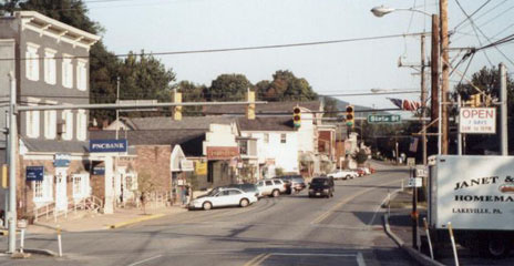
View a map showing this route.
Get your very own map showing all current and historic US routes!
Picture
Summa
1936-1954
  • East: Ft. Lee, NJ
  • West: Portland, PA​​
1954-present
  • East: Ft. Lee, NJ
  • West: Columbia, NJ
Mileage: in 1989 AASHTO listed a figure of 75 miles for US 46.  That closely matches our own 2020 measurement, which yielded 74.9 miles.

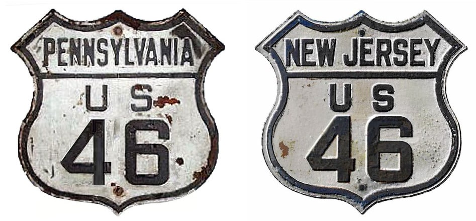
Claim to fame: US 46 is the shortest two-digit US route.  At only 75 miles in length, and entirely in one state, one could easily argue that this highway does not deserve a two-digit number, and/or that it does not deserve to be signposted with a US highway shield at all (interesting history in this blog post)...
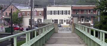
...although when US 46 was first commissioned in 1936, it did enter a second state (albeit just barely).  Originally US 611 ran through Portland but did not enter NJ.  So US 46 was signed across the Delaware River from Columbia, ending at US 611 in Portland.  That bridge connected the central parts of both towns, but it is no longer standing.  However, roughly in its place today is a pedestrian bridge:​
Picture
Elbert, Jul. 2006
That was looking southwest into Portland.  Running in front of the storefronts is PA 611 (formerly US 611), so US 46 originally ended just ahead.  On this pedestrian bridge is mounted the plaque shown here:
Picture
Elbert, July 2006
The current bridge between the two towns was opened to traffic in late 1953, which is probably why replacing the old one was deemed unnecessary.  ​
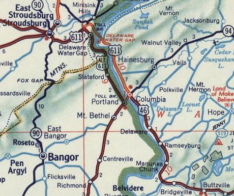
US 46 used that old bridge for only a couple years at the most.  In the mid- to late-1930s another bridge was built across the Delaware River -- this one was about two miles south of the current one, just north of the town of Delaware NJ:
Picture
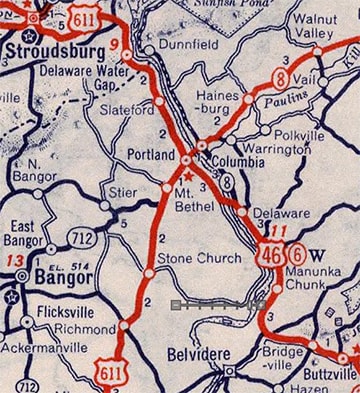
c. 1939, Rand McNally
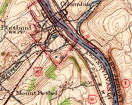
Picture
c. 1942, USGS
US 46 was routed onto this road, which aligned with River Road/Delaware Avenue in Portland.  At the time, US 611 came into Portland on State Street before heading north, so the end of US 46 was on River at State.  This photo is looking north on PA 611 (or River Rd) at State:
Picture
Nasiatka, Sep. 2003
Historically northbound US 611 came in from the left on State, and it continued straight ahead, so US 46 ended at this intersection.  Here we are looking east on State at PA 611:
Picture
Nasiatka, Aug. 2002
That was from the perspective of a driver on historic northbound US 611, which continued to the left from here.  To the right was an historic west beginning of US 46.  Here is another view:
Picture
Nasiatka, Aug. 2002
That was looking south on Route 611.  Old US 611 continued south by turning right here on State.  US 46 began straight ahead, and crossed the river into NJ (that bridge was also destroyed and no longer exists, but it ran just south of the current railroad bridge outside Delaware NJ).  

​In 1953 the current bridge was opened.  At that time, not only was US 611 moved off State in Portland to align with the new bridge, but also its route was altered so that it crossed the bridge into NJ:
Picture
c. 1956, Gousha
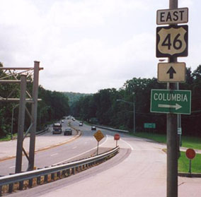
US 611 re-entered Pennsylvania at Delaware Water Gap; its old route through Portland and along the PA side of the river was christened "Alternate US 611".  Thus the west terminus of US 46 was moved out of PA, to its junction with US 611 across the river in Columbia.  Here is a photo of the modern equivalent of this junction:
Picture
Kerr
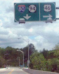
That was taken heading east into Columbia via the bridge.  That was formerly northbound 611, which veered to the left ahead (that now connects with I-80 at interchange 4).  The west beginning of US 46 was to the right.  This whole arrangement was reconfigured again in 1965, when I-80 was completed through the area.  When that happened, the US 611 designation was moved back to its original alignment (through Portland and entirely in PA).  But instead of running US 46 back across the river to US 611 in Portland, its western terminus was changed to I-80's interchange 4, where it remains to this day:
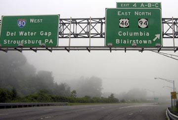
Picture
Elbert, July 2006
That signage is for the west beginning as seen from westbound I-80.  This next photo was taken from the opposite direction:
Picture
Mason, May 2002
That shows the beginning from eastbound I-80 (by 2006 that signage had changed a bit: on the left the control point is now "New York City"; and on the right "Portland" is listed before "Buttzville").  If a driver exits to US 46, this photo shows the first eastbound signs at far left...
Picture
Nitzman, 2000
...although that overhead sign had been removed by August 2002.  A few of the other signs visible in that photo are shown close-up here:
Picture
Elbert, July 2006
Picture
Elbert, July 2006
US 611 has been decommissioned, and I do not think that road is even designated NJ 611.  But the car is following an historic routing of US 611 -- at least as much as it is possible today: from 1954-1965, US 611 came south from DWG to this point, and then turned right (west) to cross the river into Portland.  US 46 began straight ahead at that turn:
Picture
Nitzman, 2000
Picture
Nasiatka, Aug. 2002
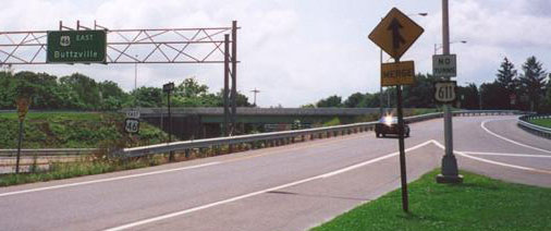
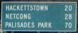
That was looking down at the former west beginning of US 46.  The on-ramp coming in from the right is from the toll bridge from Portland -- and that is roughly how northbound US 611 traffic would have turned onto eastbound US 46.  As it did then, US 46 remains in New Jersey by continuing south along the east bank of the Delaware.  That green mileage sign is interesting, because it is essentially a mileage log of the entire route of US 46 (Fort Lee is just past Palisades Park).  However, not shown on that sign is one of the first towns on US 46, one with a great name: Manunka Chunk.  Note the white hatch paint at the merge; that is also visible in the next photo, looking back in the opposite direction:
Picture
Nitzman, 2000
That shows a view of the west end of US 46 -- the aforementioned entrance from the toll bridge is visible on the left.  For a period of about 10 years, northbound US 611 went straight from here; southbound 611 went left, across to Portland; and US 46 ended here.  It still ends here -- or essentially here, at the I-80 ramp just ahead.

Picture
c. 1940, Rand McNally
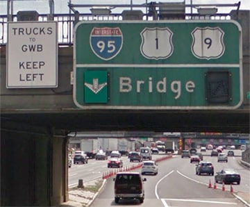
US 46 has never entered New York.  Officially the designation ends right at the New York-New Jersey state boundary, about midway across the George Washington Bridge.  Here we will examine whether or not the posted highway signs reflect that terminus point accurately.
In recent years, the final eastbound reference to US 46 has been about two miles before its terminus, on an overhead sign near the Oakdene Avenue overpass:
Picture
Google Maps Street View, Sep. 2019
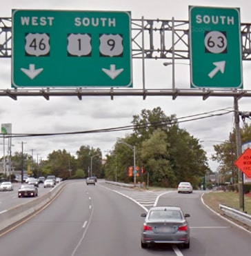
Ahead, there are two additional references to the US route designations of this highway, but both of them reflect only US 1-9 while omitting US 46:
Picture
GMSV, Sep. 2018
Picture
GMSV, Aug. 2016

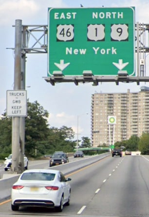
US 46 continues just a but further along this road, but one would never know it from the signs.  Its east end is directly over the Hudson River, at the NY state line.  So in a sense, US 46 has two eastern termini, one for the upper deck of the GWB, and one for the lower deck:
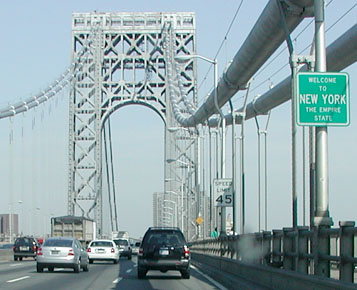
Picture
Mason, May 2002
Picture
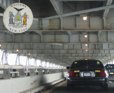
Field/Nitzman, Aug. 2005
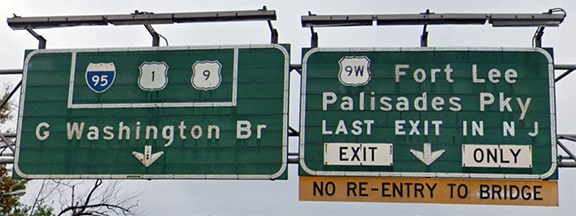
Both of those perspectives show the east end of US 46, although US 1 and US 9 continue ahead with I-95.

​
Heading the opposite direction, the US 46 designation begins without any fanfare at the New Jersey state line.  Here we are on southbound I-95/US 1/US 9... and as soon as we cross the line, we are also on westbound US 46:
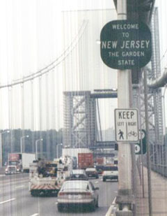
Picture
Nasiatka, Sep. 2003
Shortly after emerging from either level of the GW Bridge, there are references to the upcoming exit for US 1-9-46...
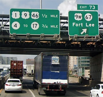
Picture
GMSV, Sep. 2018
Picture
GMSV, May 2018

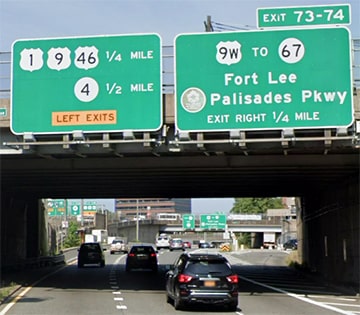
...and drivers emerging from both levels have separate lanes for the exit to US 1-9-46:
Picture
GMSV, Jul. 2018
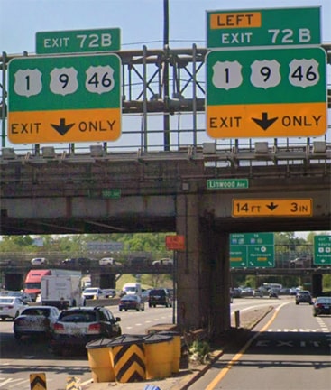
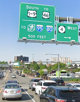
The next sign suggests that US 46 does not begin until it separates from US 1-9...
Picture
GMSV, Jul. 2018
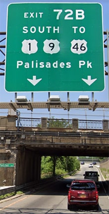
...but the first overhead sign on the mainline indicates that drivers are on all three US routes after all:
Picture
GMSV, Oct. 2013

What about intersecting routes?  Well, US 46 is referenced as far east as the Palisades Interstate Parkway, which runs essentially along the Jersey shore of the Hudson River.  In fact, only US 46 is mentioned there, whereas US 1-9 is neglected, which seems odd:
Picture
GMSV, Sep. 2019
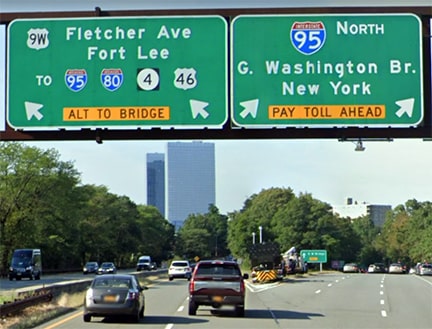
Traffic bound for US 46 ends up on Fletcher Avenue, but there (similar to what we saw above) the signs tell a different story, implying the US 46 begins where it separates from US 1-9:
Picture
GMSV, May 2021
So in summary, signage at the east end of US 46 is kind of hit-and-miss in terms of accuracy and consistency.

Research and/or photo credits: Carter Buchanan; Chris Elbert; Andy Field; Doug Kerr; Jeff Kitsko; Christopher Mason; Robert Mortell; J.P. Nasiatka; Alex Nitzman; Dale Sanderson; Michael Summa
Page originally created 2000;
last updated Dec. 21, 2021.
Copyright © 1998-2023
Picture