above: c. 1958, looking southbound
Historic US highway endpoints in Kansas City, MO
|
Today, US 56 is the only US route that ends in Kansas City. But it was not commissioned until the 1950s. During the seminal years of the US highway system, three other routes terminated in Kansas City... and then a fourth quietly ended there for at least three decades.
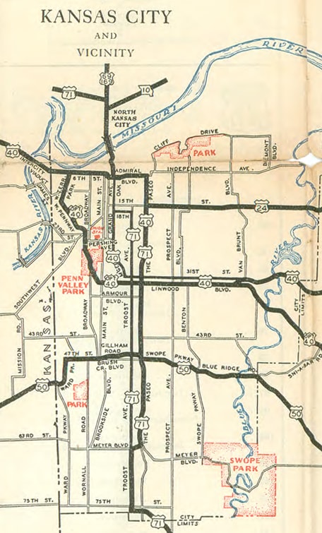
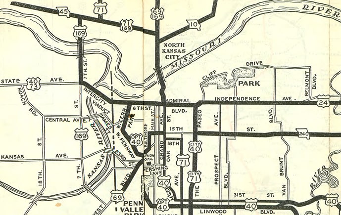
US 24, 69, and 169 have long since been extended beyond KC, but the preceding map hearkens back to the time when each of them ended in the city. Early MODoT maps included route logs, and in some cases those are helpful in determining the endpoints. For example, the route log for US 69 confirmed that the designation ended at its junction with US 40:
Starting in 1930, that map shows that US 169 joined with US 69 and the two shared a common endpoint. But in this case, the route log did not confirm the endpoint, because the listing ended at 169's junction with 69:
Some of the historic highway segments through KC have been vacated. US 69-169 came from the north across the Missouri River via the Armour-Swift-Burlington (ASB) Bridge (which closed to automobile traffic in 1987, when its functionality was replaced by the Heart of America Bridge).
|
|
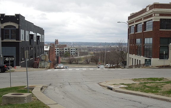
On the south side of the river, US 69-169 aligned with what is now the offramp from southbound MO hwy. 9 to 3rd Street. That road then curves over to Locust Street, where US 69-169 continued south (past the old courthouse on 5th Street). Today one can go only as far south as Missouri Avenue, because the remainder of the old road was completely erased when MO 9's interchange with I-70/35 was built. US 69-169 formerly continued down Locust to Independence Avenue, where it then jogged slightly back to the west, such that by the time it reached 6th Street, it was aligned with Oak Street (although that segment of Oak is now known as Page Street). Maps from that timeframe are unclear as to whether US 40 ran along 6th or Admiral Boulevard, but this image shows both:
|
That was looking north on Page; in the foreground, the crossroad is Admiral, while the next block ahead is 6th. US 69 either began straight ahead, or else it began one block ahead. Either way, it continued straight ahead to Locust (across where I-70/35 runs now). In 1930, that also became the south beginning of US 169.
|
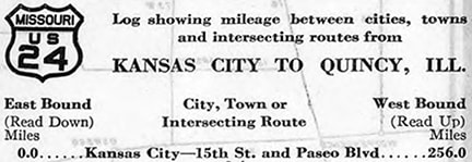
Meanwhile, the map above suggested that US 24's west end could have been at the intersection of 15th Street and Paseo, and this route log seemed to confirm that:
|
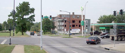
If that was indeed the case, then this photo shows the spot: this was looking south on Paseo, which at the time carried US 40-71:
|
To the left on 15th (now Truman Road) could have been the west beginning of US 24. However, I am a little skeptical about that. Suppose US 24 actually continued into the downtown area. The map did not have enough space to add another marker, and US 24's route log could have ended simply because the remainder of the route was redundant with the logs for US 40 and US 71. Based on route signage practices during those early years, I consider it more likely that US 24 turned towards the camera, joining with US 40-71, and it terminated on 6th at Oak. In other words, it would have shared a common terminus with US 69 and US 169. In the first photo above, US 24 would have begun to the right (more on this later).
|
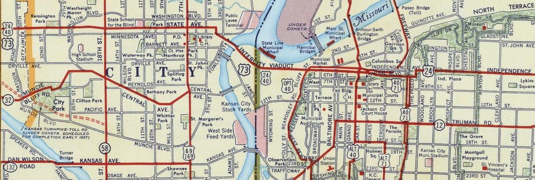
At any rate, none of this lasted for long, because in 1935 some significant US route changes took place in this part of the country. Both US 69 and US 169 were extended southward out of the KC area, and the US 59 designation was created. These creations and extensions came at the expense of US 73: US 59 replaced what had been US 73W, and much of US 73E was subsumed by US 69's extension. What remained of the US 73 designation was changed to follow the former US 73E from Horton to KC. From there, US 73 was extended east (with US 40), ending on 6th at its junction with US 71 (Oak), as illustrated on this map:
|
|
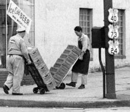
That was right about the same time US 24 was extended west from KCMO with US 40, so then there was a 17-mile stretch that was triple-signed as US 40-24-73 (most of this was along State Avenue in KCK, but also the Intercity Viaduct and 6th St. in KCMO). But how can we be certain that US 73 did not end at its junction with US 169 in KCK, or at its junction with OPT US 40 in KCMO? Early MODoT maps did not include a route log for US 73 (undoubtedly because it was overlapped with US 40-24). But we can be certain primarily because of this photo, which was taken at 6th and Broadway (east of OPT US 40). It shows a Missouri US route shield that included all three numbers:
|
|
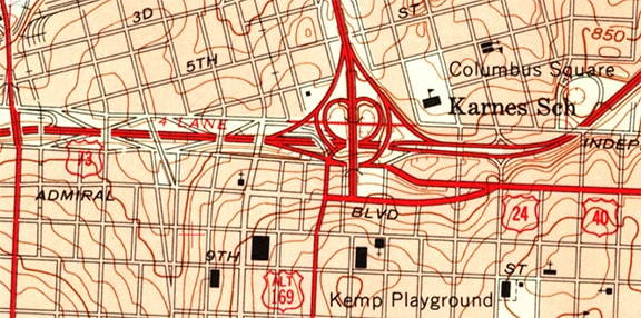
So US 73 must have extended east to Oak (US 71). And that would have been consistent with the way routes at the time were often signed all the way to a central location in the main business district, even when that required long overlaps with other routes. (And since MODoT did that with US 73, that is another reason why I believe they had probably also overlapped US 24 to the same intersection.) I have not seen any MODoT maps detailed enough to confirm or dispute that theory, but USGS maps from both 1957 and 1964 still showed US 73 ending on 6th at Oak (or actually by then its functional replacement, which was on what is now I-35/70 at the Oak interchange):
|
USGS maps are not always reliable when it comes to route designations, but in light of all the other evidence, I believe these were accurate with respect to US 73's endpoint. Following is a commercial map which also showed US 73 extending beyond US 69-169, at least to the state line:
|
So, back to the first photo on this page: starting in 1926, US 24 probably began to the right on 6th. US 69 definitely began straight ahead on Page (nee Oak), and then in 1930 US 169 also began that direction. By 1936 none of those three routes terminated in KC anymore, but instead US 73's south beginning was to the left on 6th. That remained the case for at least 30 years, and possibly almost 50 (see the main US 73 page for more details). Here is another photo showing US 73 posted on 6th, a few blocks west of Oak. The shields were posted not in numerical order, but rather in the order that they were assigned to this road:
|
Research and/or photo credits: Eric Lachmiller; Robert Mortell; Mike Roberson; Dale Sanderson
Page originally created 2007;
last updated Mar. 13, 2020.
last updated Mar. 13, 2020.
