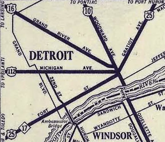
Current and historic US highway endpoints in Detroit, MI
|
1927-present
|
 |
|
After a fire almost completely destroyed Detroit in 1805, Augustus Woodward (a territory judge) designed the street pattern that would be used as the city was rebuilt. Among its most prominent features were the several boulevards that radiate outward from the original townsite, at approximately 30° increments along a 180° arc, serving all parts of the city and state. All of these boulevards converge on a point of origin called Campus Martius in downtown Detroit. 120 years after they were laid out, these boulevards began carrying Detroit's US highway traffic:
|

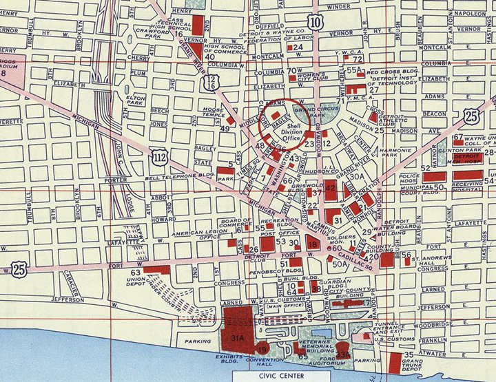
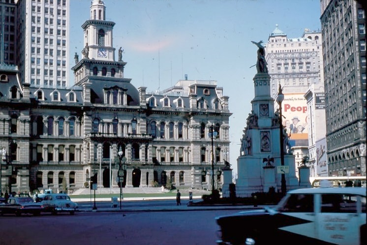
c. 1929, Automobile Blue Book
|
|
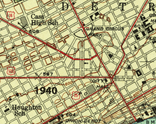
Woodward Avenue is one of the "radials" or "spokes" -- it served as US 10. Michigan Avenue is another one; US 112 travelers used it. Grand River Avenue (which was both US 12 and US 16) is another spoke. Many historic maps made it look like all four of those US routes ended at their junction with a fifth highway, US 25 (the only one that went through downtown, as opposed to ending there). This map, for example, appears to show all five US routes converging at Campus Martius. Right at that confluence of streets was a building labeled "18". That was where the grand old City Hall building stood until 1961:
|
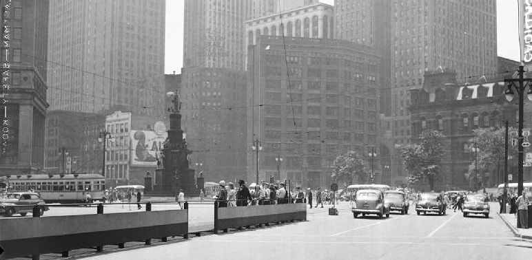
c. 1956, Gousha
|
Besides the removal of City Hall and other nearby buildings, it should be noted that other significant changes have also been made in this area since the years when all of these US routes converged here. Today the outer perimeter of Campus Martius functions as a large traffic rotary. Inside this circle is a park, and no roads pass through it. But that has been the case only since 2004. Prior to that, Woodward went straight through what is now Campus Martius Park, where there was a five-way intersection that also involved Michigan Av, Cadillac Square, and Monroe Av. During the early years of the US route system, it was quite common for a prominent, centrally-located government building to function as the point-of-origin for highway designations. So it certainly would have made sense if all of the US routes were signposted all the way to Campus Martius/City Hall, and it would have been cool if four US routes shared a common terminus there...
|
...but unfortunately, none of the evidence I have seen supports that idea. Rather, the following photos show that US 10 and US 112 did end at City Hall, but apparently US 12 and US 16 did not. In these next two photos (which were taken from the same spot, probably on the same day), the view is to the north along Woodward. The old City Hall is visible at left, and at right a sign assembly indicates that US 25 runs to the left (on Fort) and to the right (on Cadillac), while US 10 begins straight ahead on Woodward. Note that there was no reference to US 16, US 12, or US 112 (even though that route began one block ahead, to the left on Michigan, along the far side of City Hall):
|
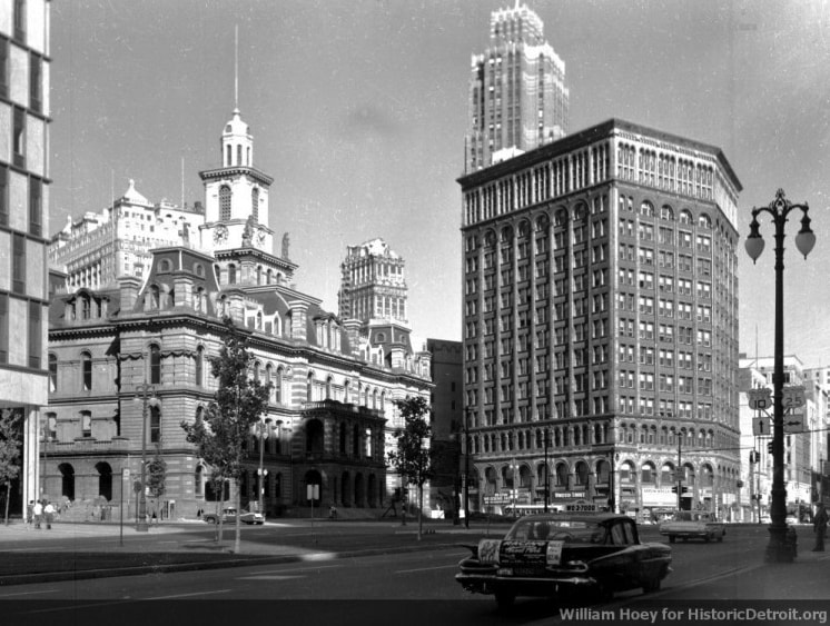
William Hoey, date unknown
|
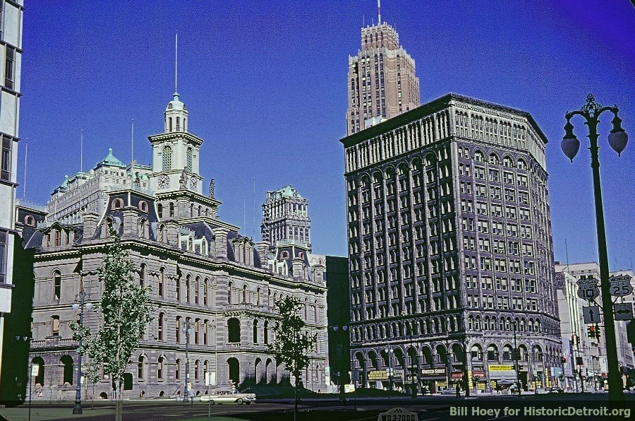
William Hoey, date unknown
|
This next photo was taken from the second or third floor of old City Hall, and the view is to the east along Cadillac. On the light pole in the foreground, there was a sign assembly for traffic heading southbound on Woodward, reading (from left to right) "US 10 ends", "US 25 left" (on Cadillac), "US 25 right" (on Fort). Again, there was no reference to US 16, US 12, or US 112:
|
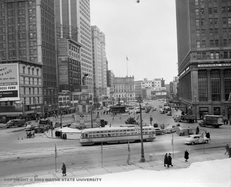
(date and attribution unknown)
|
|
This photo was looking the opposite direction (west on Cadillac, towards City Hall). Fort Street angles to the left (running past the left side of City Hall); the signpost in the foreground indicates that US 25 continues that way, while US 10 begins to the right on Woodward. No reference to US 16 or US 12... and not even US 112, which is a little strange, considering that it began right on the opposite side of the Soldier and Sailors Monument, on Michigan Ave, which ran along the right side of City Hall:
|
c. 1961
|
|
However, a US 112 marker is visible in this next photo, which was taken looking southwest on Monroe. Part of City Hall is visible straight ahead, and the Soldiers and Sailors Monument is near the center. At far right is a sign assembly indicating that US 10 ran both directions on Woodward, while US 112 began straight ahead on Michigan...
|
(date and attribution unknown)
|
|
...but still no mention of US 12 or US 16. So where did those routes terminate?
It appears that US 12 was not even overlapped with US 16 for the first 15 years or so. Rather, USGS topo maps from the early 1940s show US 12 ending on Plymouth Road at its junction with US 16 (Grand River), and Michigan DoT maps through at least 1941 corroborate that. So this photo shows what was the east beginning of US 12 at the time: |
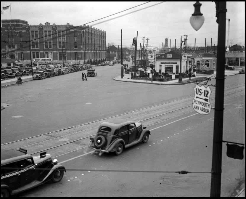
c. 1935, attribution unknown
|
|
The cars in the foreground were heading northwest on Grand River, while the road heading into the distance was Plymouth; note the US 12 shield at far right.
So then what about US 16's endpoint? Drivers heading the opposite direction (left) on Grand River were on US 16 all the way into the downtown area. The earliest MDoT maps show US 16 following Grand River all the way to Woodward, where the designation ended at its junction with US 10. And to briefly return to an earlier point: note that US 12 was not shown on the following map. Again, I believe that is because the route did not began until Plymouth Rd, which was off the northwest corner of this map: |
c. 1927, MDoT
|
|
Starting with the 1938 issue, MDoT maps began showing US 16 turning south off Grand River onto Washington Boulevard, ending at its junction with US 112 on Michigan Ave (instead of connecting with US 10/Woodward). Unfortunately the scanned images of those maps are not very high-resolution. However, the difference in those final two blocks of US 16 were nicely illustrated on the 1940 and 1947 issues of the USGS topo map. This next animated map switches between both versions; US 16's two Detroit endpoints are shown near the center:
|
c. 1940 and 1947, USGS
|
Based on the lack of US 16 shields in the photos above, I have to conclude that US 16 must have initially ended on Grand River at Woodward (US 10), and later on Washington at Michigan Av (US 112).
|
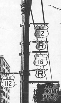
According to MDoT inset maps, it was about 1943 when the US 12 designation was overlapped with US 16, so then both routes ended on Washington at Michigan (as illustrated on the 1956 map towards the top of this page). This photo was taken during that timeframe:
|
date and attribution unknown
|
That was looking west on Michigan, approaching the point where US 12-16 began to the north on Washington in order to get to Grand River Av. (the "R" shields directed US 12 and US 16 traffic to turn right). US 16 began there for 24 years (until 1962, when US 16 was completely removed from Michigan). US 12 ended there until 1956, and then for a few years US 12 traffic was directed onto what is now known as the Edsel Ford Freeway. That highway was also signposted as I-94, but reportedly the US 12 designation ended at Woodward (US 10):
|
Fearer, Apr. 2019
|
Regardless, that arrangement lasted for only a brief time, because in 1962 MDoT decommissioned the US 112 designation, replacing it with a rerouted US 12. So then US 12 ended at Campus Martius, where US 112 had previously terminated: on Michigan at Woodward (although by then the old City Hall had just recently been torn down).
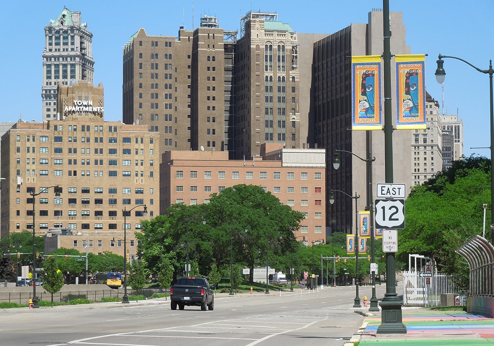
Following are some modern photos taken heading eastbound on the last mile or so of US 12 (click on any to view a larger version). This first one shows what was the final eastbound trailblazer at the time, which was posted right where Michigan passes over the Lodge Fwy:
|
Sanderson, Jun. 2022
|
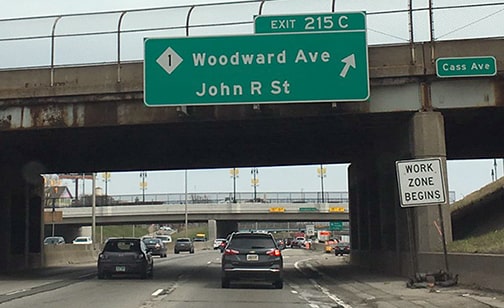
A half-mile ahead, we come to Cass Avenue, which has been the east end of US 12 since 2005 (an "END US 12" assembly was posted here in 2015, but that lasted only a couple years):
|
Sanderson, Jun. 2022
|
|
The next block is the aforementioned intersection with Washington, where US 12 and US 16 historically began to the north (left):
|
Sanderson, Jun. 2022
|
|
The next block is Shelby Street, where until about 2010 there was still a US 12 trailblazer posted, even though it had become inaccurate in 2005:
|
Ivy/Nitzman, 2009 (gone by 2011)
|
|
Prior to 2005, the US 12 designation terminated at the next block (Griswold Street), which is shown here:
|
Sanderson, Jun. 2022
|
|
In one more block we reach the current east end of Michigan where it intersects southbound Woodward. Historically Michigan extended a little further east, to just beyond where the hedges are now, ending at the original alignment of Woodward:
|
Sanderson, Jun. 2022
|
|
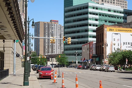
Before the redevelopment of Campus Martius, one could continue straight ahead onto Cadillac Square. This was the east end of US 112 until 1962, and then the east end of US 12 until 1981:
|

Wiley, 2000
|
|
This next shot was looking south on Woodward from State/Gratiot. Visible one block ahead is Campus Martius Park, which Woodward circumnavigates. But originally Woodward went straight ahead through what is now the park. Right about where the hedges are drivers could turn right on Michigan, and that was the east beginning of US 112 (and later US 12):
|
Fearer, Apr. 2019
|
|
In 1970, the US 10 designation was removed from Woodward, and traffic was instead directed to use the Lodge Freeway. At the river, that road curves to align with Jefferson Avenue, and US 10's new terminus was at its junction with Woodward. In 1981, US 12 was extended south from Campus Martius on Woodward, ending at Jefferson (right where US 10 began). Five years later, US 10 was truncated out of Detroit, but US 12's terminus remained for another 15 years. This photo was taken looking south on Woodward at Jefferson, showing what was at the time the east end of US 12:
|

Wiley, 2000
|
|
During that time, US 12 was not signposted anywhere along Woodward. One had to turn east on Michigan to see the first confirming marker, which was posted at Griswold Street:
|
Wiley, 2000
|
The year after that photo was taken, in preparation for the Campus Martius redevelopment, the US 12 designation was removed from those four blocks on Woodward, as well as one block of Michigan Av, such that its new terminus was there at Griswold.
|
|
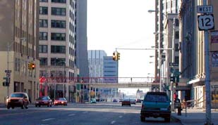
Continuing ahead on Michigan, in two blocks is Washington, the former terminus of US 16 and US 12. One block beyond that is Cass Avenue, which marks the current terminus of US 12. Historically the first confirming marker was posted one block later, just past 1st Street, but by 2017 it had been removed. After that time, the first US 12 trailblazer was just past 3rd Street, but by the time I visited in June 2022, that too had been recently removed. At that time, there was no US 12 reassurance marker until just west of Trumbull, shown here:
|
Sanderson, Jun. 2022
|
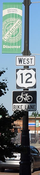
The second trailblazer was just past Rosa Parks Boulevard, and behind it were some of the cool vintage signs in the heart of the Corktown neighborhood:
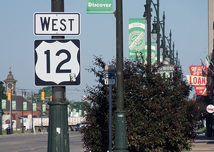
Sanderson, Jun. 2022
Many things have changed in Detroit since the '50s: Michigan has been at the forefront of the movement to decommission US routes, and US 12 is the only one that still serves the downtown area. Of course the radial avenues are still there, but today most traffic uses the newer freeway network which obscures the grand design of the underlying street pattern.
|
Research and/or photo credits: Chris Bessert; Tom Fearer; Brent Ivy; Alex Nitzman; Paul Pinto; Mike Roberson; Dale Sanderson; Mike Wiley
Page originally created 2000;
last updated Nov. 25, 2023.
last updated Nov. 25, 2023.
