US Ends .com
  • Home
  • Store
    • US highway book
    • US highway map
    • Florida US highway map
  • Endpoints
    • US 1 - US 9 >
      • 1 >
        • 201
        • 301
        • 401 [i]
        • 401 [ii]
        • 401
        • 501
        • 601
        • 701
      • 2w >
        • 102
      • 2e >
        • 202
        • 302
      • 3
      • 4 >
        • 104
      • 5
      • 6 >
        • 106
        • 206
      • 7
      • 8
      • 9 >
        • 109*
        • 209
        • 309
    • US 10 - US 19 >
      • 10 >
        • 110
        • 210
        • 310
        • 410
      • 11 >
        • 111
        • 211
        • 311
        • 411 [i]
        • 411 [ii]
        • 411
        • 511*
        • 611
        • 711*
      • 12 >
        • 112
        • 212
        • 312
      • 13 >
        • 113
        • 213
      • 14
      • 15
      • 16 >
        • 116
        • 216
      • 17 >
        • 17-1
        • 117 [i]
        • 117
        • 217
      • 18 >
        • 118
        • 218
      • 19 >
        • 119
        • 219
        • 319
    • US 20 - US 29 >
      • 20e >
        • 120
        • 220
        • 320
        • 420
      • 20w
      • 21 >
        • 121 [i]
        • 121
        • 221
        • 321
        • 421
        • 521
      • 22 >
        • 122 [i]
        • 122 [ii]
        • 222
        • 322
        • 422e
        • 422w
        • 522
        • 622*
      • 23 >
        • 123 [i]
        • 123
        • 223
      • 24 >
        • 124
        • 224
      • 25
      • 26 >
        • 126
      • 27 >
        • 127
        • 227
      • 28
      • 29 >
        • 129
    • US 30 - US 39 >
      • 30 >
        • 130
        • 230
        • 330
        • 430
        • 530
        • 630*
        • 730
        • 830
      • 31 >
        • 131
        • 231
        • 331 [i]
        • 331
        • 431
      • 32
      • 33
      • 34
      • 35
      • 36 >
        • 136
      • 38 >
        • 138
    • US 40 - US 49 >
      • 40 >
        • 140
        • 240
        • 340
      • 41 >
        • 141
        • 241 [i]
        • 241 [ii]
        • 341
        • 441 >
          • 441n
          • 441s
        • 541
        • 641
      • 42
      • 43
      • 44
      • 45
      • 46
      • 48 [i]
      • 48 [ii]
      • 48
      • 49
    • US 50 - US 59 >
      • 50 >
        • 150
        • 250
        • 350
        • 450
        • 550
        • 650
      • 51 - 55 >
        • 51 >
          • 151
        • 52 >
          • 152
        • 53
        • 54 >
          • 154
        • 55
      • 56 >
        • 156
      • 57
      • 58 >
        • 158
        • 258
      • 59 >
        • 159
        • 259
    • US 60 - US 69 >
      • 60 >
        • 160
        • 260
        • 360
        • 460
      • 61 - 65 >
        • 61 >
          • 161
        • 62
        • 63 >
          • 163 [i]
        • 64 >
          • 164 [i]
          • 164 [ii]
          • 264
        • 65 >
          • 165
      • 66 >
        • 166
        • 266
        • 366 [i]
        • 366 [ii]
        • 466 [i]*
        • 466 [ii]
        • 566
        • 666
      • 67 >
        • 167
      • 68 >
        • 168
      • 69 >
        • 169
    • US 70 - US 79 >
      • 70 >
        • 170
        • 270 [i]*
        • 270
        • 370
        • 470
      • 71 >
        • 171
        • 271
        • 371 [i]
        • 371 [ii]
        • 371
      • 72 - 76 >
        • 72
        • 73
        • 74
        • 75 >
          • 175
          • 275
        • 76 >
          • 176
          • 276
      • 77 >
        • 177
        • 277
        • 377
      • 78 >
        • 178
        • 278
        • 378
      • 79
    • US 80 - US 89 >
      • 80 - 84 >
        • 80 >
          • 180 [i]
          • 180
          • 280
          • 380
        • 81 >
          • 181
          • 281
        • 82
        • 83 >
          • 183
          • 283
          • 383
        • 84
      • 85 - 89 >
        • 85 >
          • 185
          • 285 [i]
          • 285
          • 385 [i]
          • 385
          • 485
        • 87 >
          • 187
          • 287n
          • 287s
        • 89n
        • 89s >
          • 189 [i]
          • 189
    • US 90 - US 99 >
      • 90 - 94 >
        • 90 >
          • 190
          • 290
        • 91 >
          • 191 >
            • 191n
            • 191s
          • 491
        • 92 >
          • 192
        • 93
        • 94
      • 95 -98 >
        • 95 >
          • 195
          • 295
          • 395
        • 96 [i]
        • 96
        • 97 >
          • 197
        • 98
      • 99 >
        • 199
        • 299
        • 399
    • Anomalies >
      • 101
      • 163
      • 400
      • 412
      • 425
  • Places
    • A-L >
      • A >
        • Aberdeen
        • Albuquerque
        • Amarillo
        • Apalachicola
        • Astoria
        • Atlantic
      • B >
        • Baltimore
        • Baton Rouge
        • Bay Area
        • Bishop
        • Boone
        • Brady
        • Bristol
        • Brownsville
        • Brunswick
      • C >
        • Charleston
        • Chattanooga
        • Chicago
        • Cincinnati
        • Cleveland
        • Cody
        • Corpus
        • Cortez
        • Council Bluffs
        • Covington
        • Crescent
        • Cumberland Gap
      • D-E >
        • Dallas
        • Des Moines
        • Detroit
        • Dothan
        • Douglas
        • El Paso
        • Erie
        • Eugene
      • F >
        • Farmington
        • Flagstaff
        • Florence
        • Fox Valley
        • Franklin
      • G >
        • Gallup
        • Georgetown
        • Grand Junction
        • Grand Portage
        • Grayling
        • Great Falls
        • Greeley
      • H-I >
        • Hardeeville
        • Harrisburg
        • Holbrook
        • Idaho Falls
        • Int'l Falls
      • J-K >
        • Jacksonville
        • Joplin
        • Junction
        • Kansas City
        • Keokuk
        • Key West
        • Kingman
      • L >
        • Laredo
        • Lewiston
        • Long Beach
        • Los Angeles
        • Louisville
        • Lubbock
    • M-R >
      • M >
        • Mackinaw
        • Madison
        • Maryhill
        • Maysville
        • Miami
        • Midway
        • Miles City
        • Milford
        • Milwaukee
        • Minneapolis
        • Mobile 31
        • Mobile 31-43-45
        • Montgomery
        • Monticello
        • Mount Vernon
      • N-O >
        • Nags Head
        • Naples
        • Natchez
        • New Castle
        • New Orleans
        • Niagara
        • Norlina
        • Ocean City
        • Oklahoma City
      • P >
        • Pee Dee
        • Pembina
        • Pensacola
        • Petersburg
        • Philadelphia
        • Piegan
        • Pineville
        • Port Arthur
        • Portsmouth
      • Q-R >
        • Quad Cities
        • Rapid City
        • Raton
        • Reading
        • Richmond
        • Rockingham
        • Rouses Point
    • S-Z >
      • S >
        • San Antonio
        • San Antonio NM
        • San Diego
        • Santa Fe
        • Savannah
        • Sioux
        • Springer
        • Springfield
        • St. Ignace
        • St. John
        • St. Paul
        • St. Pete
      • T-U-V >
        • Tallahassee
        • Tampa
        • Toledo
        • Trinidad
        • Tuba City
        • Ucolo
        • VA Beach
      • W >
        • Walterboro
        • Waverly
        • West Memphis
        • Wilmington
        • Wilson
        • Wrightsville
      • Y >
        • Yellowstone E
        • Yellowstone N
        • Yellowstone NE
        • Yellowstone S
        • Yellowstone W
  • Highways
    • Map of all endpoints
    • Sources
    • History
    • 1926 almost-routes
    • Intra-state routes
    • Numbering
    • Colors
    • Gaps
    • Blog
  • Bonus
    • Colorado >
      • Lowest point
      • Antipodes
      • Toponymy >
        • Roots
      • Colloquialisms
      • Populations
      • Denvers
    • Washington Meridian
    • Watersheds >
      • Headwaters Hill
      • Three Waters Mtn.
      • Parting of the Waters
    • Geo-centers >
      • 48 states
      • 50 states
      • North America
    • State corners >
      • AZ-CO-NM-UT
      • CO-UT-WY
      • CO-NE-WY
      • CO northeast
      • CO-KS-NE
      • CO-KS-OK
      • CO-NM-OK
      • NM-OK-TX
      • NM southeast
      • TX northwest
  • Connect
    • Author/history
    • Rationale
    • Contact
    • Contributors
    • Submissions

^ app. Beaver River in Okla. panhandle;
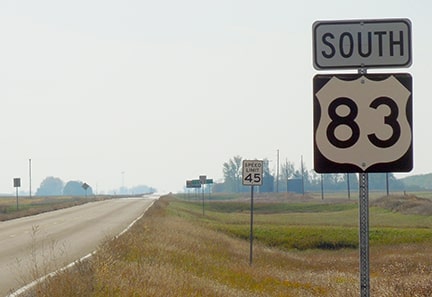
​Stew Magnuson, Sep. 2015 (source)

End of US highway 83

View a map showing this route.
Get your very own map showing all current and historic US routes!
Picture
Summa
Picture
Summa
1926-1930
  • North: near Bismarck, ND
  • South: near Pierre, SD
1930-present
  • North: near Westhope, ND
  • South: Brownsville, TX
Get your copy of this epic book that commemorates the first century of the US route system!

Mileage: in 1989 AASHTO listed a figure of 1907 miles for US 83... however, that included the mileage of US 83's associated business routes.  According to the state subtotals on AASHTO's 1989 spreadsheet, mainline US 83's actual end-to-end total at the time was 1894 miles.  That is reasonably close to our own 2020 measurement, which yielded 1882.2 miles.  Want historic mileages?  Our handy reference book includes the mileages that were published in all 13 of AASHO/AASHTO's historic route logs (spanning the years 1927 to 1989).
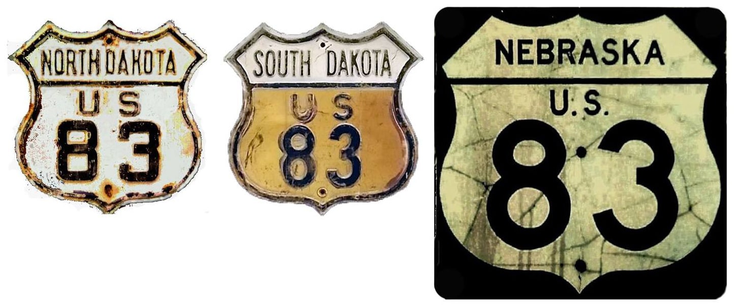
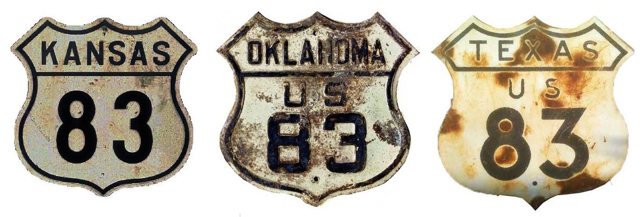
Claim to fame: of its total distance, 893.1 miles of US 83 are in Texas (or nearly half of the entire highway).  That is the longest single-state mileage of any current US route.  US 83's midway point is near Liberal, Kansas (which is only about 40 miles north of the Texas line).
US 83 was among the original 1926 routes, but at the time it measured less than 200 miles in length.  Its north end was at US 10 outside Bismarck, at Sterling:
Picture
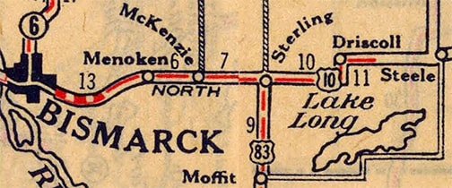
c. 1927, Rand McNally
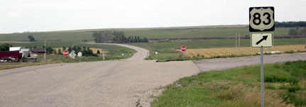
In that area, historic US 10 runs about a mile south of I-94; this photo was looking eastbound on old US 10:
Picture
Otterson, Aug. 2004
The stop signs in the middleground are at US 83's mainline, and the curve to the right is a slip-ramp to southbound US 83.  Normally a county road like this would not have guide signage for an intersecting highway, so that assembly may be a carryover from the era during which this was still US 10.  However, by the time that diagonal segment of US 10 had been built, US 83 no longer ended there.  Prior to the 1940s, US 10 stair-stepped along section-line roads.  During the late 1920s, US 10 followed 17th Avenue NE as far east as Driscoll, so US 83's endpoint was about an 8th-mile to the south (right) from the junction shown above.  In this interactive image, the view is to the north on US 83.  The crossroad is 17th Av, which carried the original US 10, so this was the north end of US 83.  The buildings visible in the distance mark the location of County Road 10, which was a later alignment of US 10:

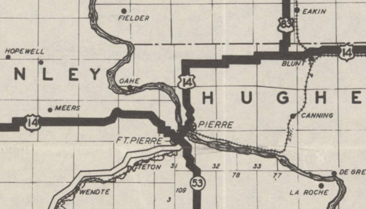
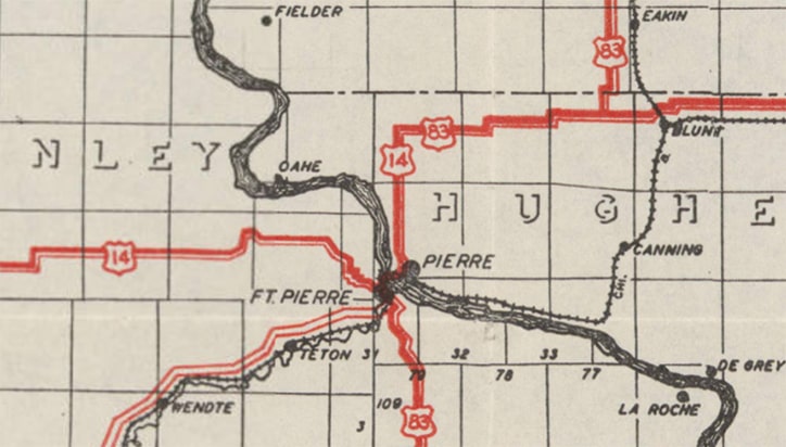
​​Pinpointing the location of US 83's original south terminus presents a bit of a challenge.  On the one hand, AASHO's Nov. 1926 map and Apr. 1927 route log both specify "Pierre" as the endpoint.  US 83's intersection with US 14 was in a remote area, about three miles west of the small town of Blunt.  During the early years of the US route system, designations that junctioned in a rural area were commonly overlapped into a nearby city, so it would have made sense for US 14-83 to overlap into downtown Pierre.  But on the other hand, it is possible that SD did not signpost US 83 between Pierre and Blunt.  I have never seen an early map that showed a US 14-83 concurrency along that 18-mile stretch.  Even though there was plenty of space to label that segment with both shields, that did not happen until 1931, and that was only because US 83 was extended south of Pierre by then:
Picture
c. 1930, SDDoT
Picture
c. 1931, SDDoT
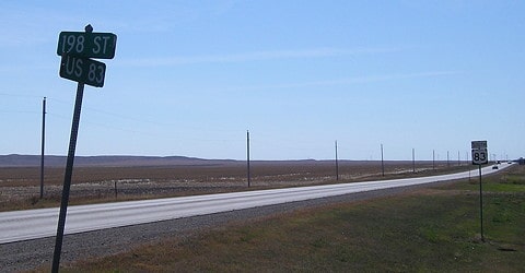
So at this point it is inconclusive whether the maps or the route logs were correct.  If US 83 ended at US 14 northeast of Pierre, near Blunt, then it is important to know that originally eastbound US 14 out of Pierre followed today's SD hwy. 1804 northward.  Near Oahe Dam, where 1804 veers northwest, US 14 continued due north on what is now CR 153, to the community of Gray Goose.  There, US 14 turned due east along today's CR 805, which joins the modern alignment of US 14 about two miles west of Blunt.  Three miles west of Blunt is the junction with US 83, and that may have been the original south terminus of US 83.  This image was looking south on US 83.  ​Running across the photo is 198th Street, or CR 805.  That was the original route of US 14, so this was the original south terminus of US 83:
Picture
Morrison, Oct. 2020
1930 saw the north terminus of US 83 extended from Bismarck up to Canada, and the south terminus extended all the way through Texas to a Mexican border crossing in Brownsville.*  Thus US 83 became an international highway; it is about 1900 miles long, making it one of the longest north-south US routes.  While US 83 is signed as a north-south road in Brownsville, it is signed east-west elsewhere in the Rio Grande Valley, from Harlingen to the Hidalgo-Starr county line, just west of Sullivan City.  This was true even before an interstate with an east-west number (I-2) was designated along the US 83 freeway.
*Actually the highway was commissioned from Canada to Mexico, but it was not immediately signposted along that entire length.  The history of US 83 and its branch routes (183, 283, and 383) is complex; it is covered in much more detail on this blog post.

​This next photo shows the last northbound US 83 marker, which was posted in the town of Westhope:
Picture
Sanderson, Oct. 2021
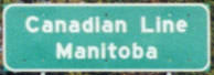
Six miles ahead, there was no "End" sign at its northern terminus, but these photos show the spot where US 83 ends, where the highway crosses into Canada:
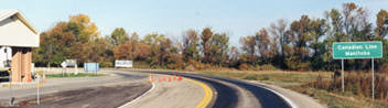
Picture
Taylor, 2000
Picture
(detail)
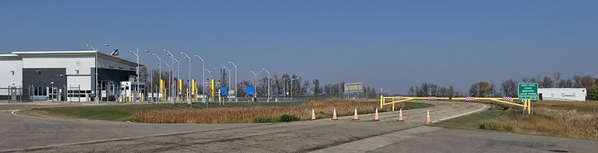
The US customs station shown there has since been replaced with the one visible in this photo:
Picture
Sanderson, Oct. 2021
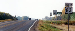
That border station is also known as Westhope; its Canadian counterpart is called Coulter.  US 83 continues as Manitoba hwy. 83.  These shots show the first US 83 sign as one heads south from the international border:
Picture
Taylor, 2000
Picture
Sanderson, Oct. 2021

Research and/or photo credits: Nathan Edgars; Stew Magnuson; Jeff Morrison; Bob Otterson; Dale Sanderson; Michael Summa; Stephen Taylor
Page originally created 2000;
last updated Oct. 26, 2021.
Copyright © 1998-2025
Picture