End of US highway 75 |
 |
Summa
|
Summa
|
|
Mileage: historically, when US 75 went to Galveston, it was 1523.8 miles long. After it had been truncated to Dallas, in 1989 AASHTO listed a figure of 1296 miles for US 75... however, that included the mileage of US 75's associated business/bypass/alternate routes. According to the state subtotals on AASHTO's 1989 spreadsheet, mainline US 75's actual end-to-end total at the time was 1239 miles. That closely matches our own 2020 measurement, which yielded 1234.8 miles (reroutings and realignments likely explain the difference).
|
|
|
Ever since the US routes were first commissioned in 1926, the north end of US 75 has been at the Canada port of entry between Noyes MN and Emerson MB:
|
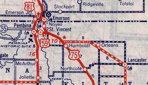
c. 1939, Rand McNally
|
|
That remains the case (US 75 is still signed to the border as of 2007), but since 2003 that border crossing has been closed:
|
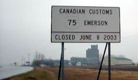
Nelson, Apr. 2005
|
It was actually Canada that closed their side of the port in 2003, citing such factors as the age of the facility, the proximity of another port, and workload and resource considerations. And apparently the port is still open to train traffic. So theoretically the U.S. could have opted to continue letting automobile traffic come in from Manitoba via the Port of Noyes (even though people could no longer leave the U.S. that way). But most of the reasons Canada cited also apply to the U.S. At any rate, it appears the U.S. "unofficially" closed the Port of Noyes at the same time Canada closed its port, but it was not until 2006 that Noyes was procedurally and legally closed.
|
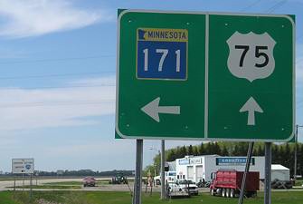
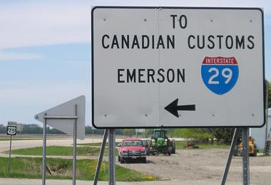
Since 2003, Canada-bound traffic on US 75 has been directed to follow MN hwy. 171 west into North Dakota, where it becomes ND hwy. 59, which joins I-29 at interchange 215. But so far, it appears that Minnesota and North Dakota have not yet petitioned AASHTO to change the definition of US 75 to follow that routing. As of 2007, US 75 was still signed to what is now a dead-end at the old border crossing:
|
Morrison, May 2007
|
|
The white sign in the background is shown close-up below:
Morrison, May 2007
|
Drivers are clearly informed that they should cross over to Pembina and use the I-29 port of entry. So it is questionable whether it still makes sense to sign US 75 north from this junction. This photo shows the north end of US 75:

Morrison, May 2007 (gone as of 2018)
|
|
That is the Port of Noyes, now closed and sold to a private owner. Ahead is Mantioba hwy. 75, which continues into Winnipeg. The backside of the sign in the foreground is shown in this photo:
|
Morrison, May 2007 (gone as of 2018)
|
|
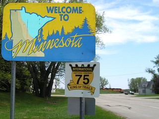
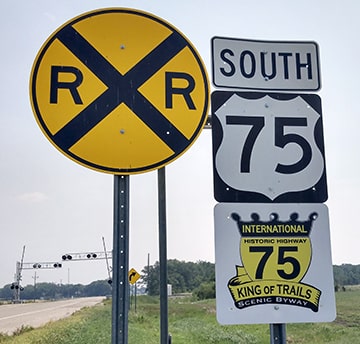
That says "International Historic Highway 75 - King of Trails". It is unfortunate that this port has closed, because this historic highway association has done a good job of signing and promoting US 75. The first mention of US 75 is ahead at the junction with MN 171, and the first southbound marker is posted just beyond there:
|
Nelson, Apr. 2005
|
Turner, Jul. 2021
|
|
Originally US 75 went all the way down to Galveston. South of Dallas, it essentially followed what is now the I-45 corridor. US 75 reached its southernmost point where it landed on Galveston Island -- from there, it turned east (but also slightly north) along what was then called Avenue J (now Broadway, or TX 87):
|
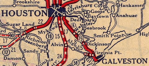
c. 1927, Rand McNally
|
|
Exactly where US 75 ended is a bit uncertain. The 1940 and 1961 TXDoT maps suggest that US 75 ended at the 20th Street intersection. Although that is not a major north-south road in town, these maps seem to place some significance on this intersection, by marking it with an asterisk and using it as a mileage point-of-reference:
|
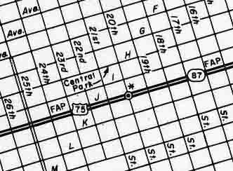
c. 1961, TXDoT
|
|
The Galveston inset on the 1945 official state highway map also seemed pretty explicit that 20th was the endpoint, and moreover, it suggested a reason: that was the location of the county courthouse:
|
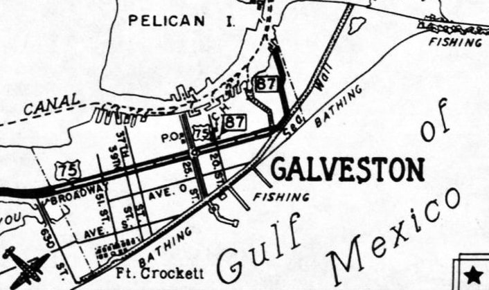
c. 1945, TXDoT
|
|
So apparently 20th marked the end of US 75 and the beginning of TX 87. This photo was taken looking west on Broadway at 20th:
|
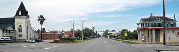
Karners, Jan. 2015
|
|
At one time, that may have been the end of TX 87, and US 75 began straight ahead. Adding to the plausibility of that theory is the fact that the courthouse is located a couple blocks to the right (north) on 20th.
However, it appears that by the 1970s US 75 was extended to the east end of Broadway, ending at Seawall: |
c. 1972, TXDoT
|
|
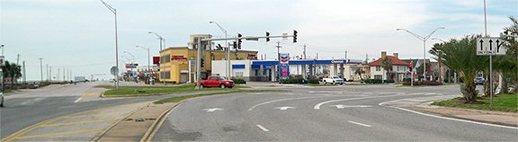
This photo was taken looking east on Broadway -- for a time, US 75 ended here, with TX 87 signage beginning where the road curves left to become Seawall:
|
Karners, Jan. 2015
|
|
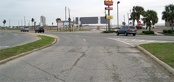
Straight ahead was a large sign at the entrance to Stewart Beach, one of the large public beaches on Galveston Island.
Here is a shot from the opposite perspective: |
Karners, Jan. 2015
|
|
The view there is southwest on Seawall. Formerly that is where TX 87 signage ended, while US 75 began where the road curves into Broadway (to the right). Just over four miles that direction is the south beginning of I-45.
|
c. 1970, Staley
|
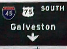
It was in 1987 that TXDoT decided US 75 south of Dallas had been rendered obsolete by I-45. Here is that agenda item from the minutes of AASHTO's meeting in May of that year:
|
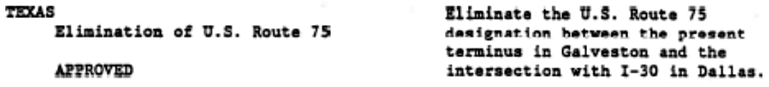
So the TX 87 designation was extended west along Broadway, replacing US 75, and ending where I-45 began (and this is the arrangement currently in place). But one can still drive most of old US 75 in Texas, including the segment that is now marked as TX hwy. 75 from Streetman to Conroe. And as of 2021 some US 75 signs were still standing in Houston.
|
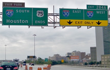
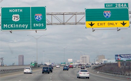
Already by the time of the 1987 TXDoT map, US 75 was shown cut back to its current south terminus in Dallas. This photo was taken looking south at the Live Oak Street exit downtown. An "End" sign is posted here, even through US 75 (and secret I-345) actually continue ahead for another mile. But those designations end at I-30, so it was probably appropriate to locate the "End" sign where I-30 traffic splits off from the mainline:
|
Karners, Jan. 2012
|
|
Here is the signage heading the opposite direction (north at the end of I-45 and the south beginning of US 75/I-345):
|
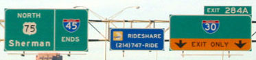
Cozart, Dec. 2002
|
|
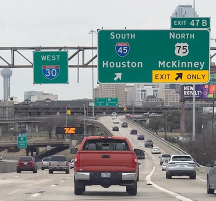
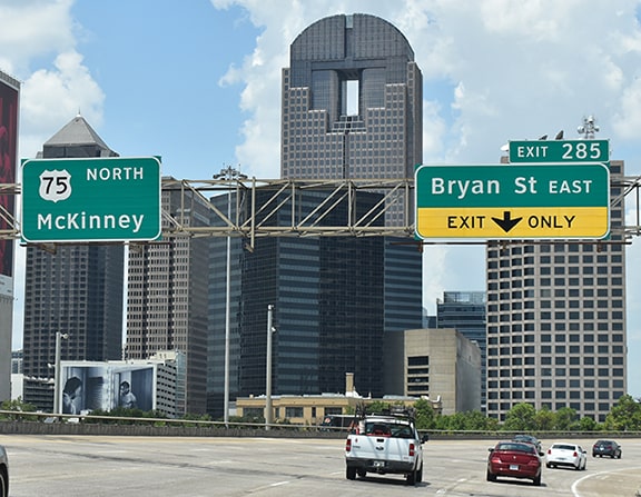
In August 2007, those panels were replaced with Clearview versions, and the control city for US 75 was changed from "Sherman" to "McKinney":
|
Karners, Jan. 2012
|
|
Also, the interstate shields are more compliant now. These next photos show the south beginning of US 75 from the perspective of westbound I-30:
|

Cozart, Dec. 2002
|
Sanderson, Feb. 2021
|
|
From eastbound I-30, US 75 and I-45 traffic is directed onto a C-D road; these next photos show the signs where the routes split:
|
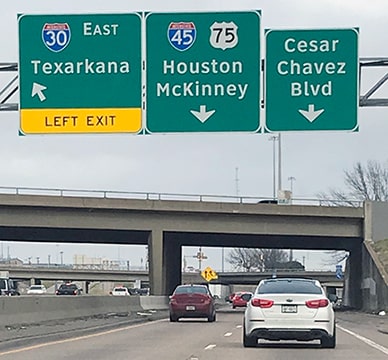
Sanderson, Feb. 2021
|

Cozart, Aug. 2007 (same as of 2021)
|
|
For drivers following the left fork, the first US 75 sign on the mainline looks like this:
|
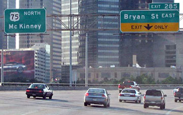
Cozart, Aug. 2007
|
Ivy/Nitzman, Aug. 2019
|
Research and/or photo credits: Justin Cozart; Nathan Edgars; Mark Handler; Brent Ivy; Karin and Martin Karner; Jeff Morrison; Steven Nelson; Alex Nitzman; Mike Roberson; Dale Sanderson; Earl Staley; Michael Summa; Stephen Taylor, Charles Turner
Page originally created 2003;
last updated Oct. 26, 2021.
last updated Oct. 26, 2021.
