End of US highway 160 |
 |
Summa
|
Summa
|
|
1930-1934
|
1934-1938
|
1938-1953
|
|
1953-1970
|
1970-2007
|
2007-present
|
|
Claim to fame: US 160 is the longest east-west 3-digit US route.
|
|
Mileage: in 1989 AASHTO listed a figure of 1477 miles for US 160... however, that included the mileage of US 160's associated business route. According to the state subtotals on AASHTO's 1989 spreadsheet, mainline US 160's actual end-to-end total at the time was 1474 miles. That closely matches our own measurement of 1476.2 miles... however, that was when US 160 went to Poplar Bluff. Since then it has been truncated, and our 2020 measurement yielded 1466.0 miles.
When US 160 was originally commissioned in 1930, its west terminus was in Trinidad, either at its junction with US 85 (right in town), or else at US 350 at Beshoar Junction (about seven miles northeast of town). Photos, maps, and more information can be found on the Trinidad page. At the time, its east endpoint was in Springfield.
|
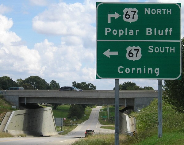
In 1934, US 160 was extended north from Trinidad with US 85 to Walsenburg CO, and then west along the former route of US 450. For a few years the designation ended at the Utah state line near Ucolo, west of Dove Creek CO (because Utah kept the US 450 designation in their state for another few years). But then in 1938, US 160 subsumed the remainder of old 450 all the way up to Crescent Jct. In 1970 US 160 was truncated at Cortez CO and instead extended southwesterly along the former US 164, terminating at its junction with US 89 west of Tuba City AZ.
In 1953 US 160 was extended east to Poplar Bluff. Before the modern bypasses were built, US 67 traffic used Westwood Boulevard (today's Business 67), and US 60 used Pine Street and Westwood (today's Business 60). There were probably even earlier routings before Westwood was built, but by the time US 160 arrived in Poplar Bluff, Westwood was already there: |
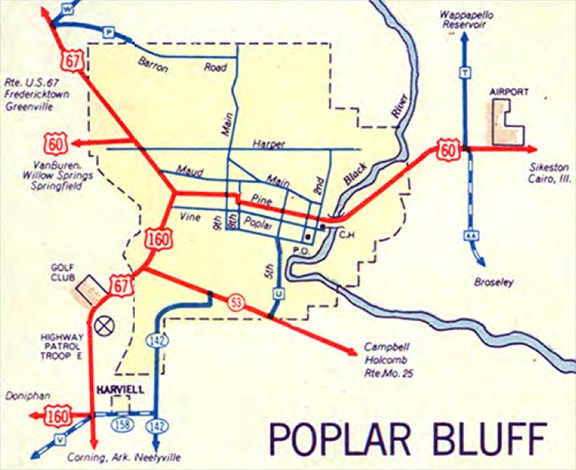
c. 1954, MO DoT
|
|
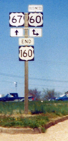
Also note where US 160 split from US 67 in the lower left corner, near Harviell: that is where US 160 has ended since 2007. But first, its historic endpoint: this photo was looking north on Westwood, showing signage at the historic east end of US 160:
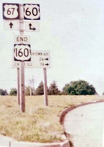
Brown, May 1985
|
At the time of that photo, mainline US 60 traffic was still routed through town, and a sign was posted with mileages to Fredericktown, Dexter, and Cairo. But by the late 1980s, US 60 had been moved to its current bypass along the north edge of Poplar Bluff. The old US 60 was then signposted as Business US 60, but the US 160 designation was not extended to connect with the new US 60. Rather, it continued to terminate at the same location as before, such that the east end of US 160 was at its junction with Business 60:
The "End 160" panels shown in that last photo were removed by October of that same year. Besides Business US 67, straight ahead is also westbound historic US 60, now Business 60. To the right on Pine is eastbound historic/Business 60.
|
|
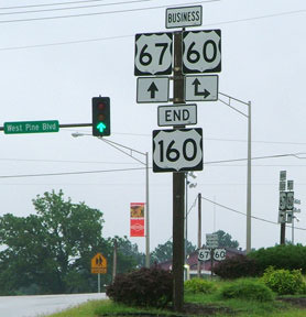
This shot was taken from the west end of Pine, on westbound Business 60. That designation continues to the right, along with northbound Business 67. To the left is southbound Business 67. Also to the left was the east beginning of US 160:
|
Sanderson, July 2007
|
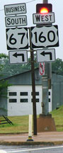
Those US 160 panels were also removed shortly after that photo was taken. Here, we are looking south on Westwood:
|

Sanderson, July 2007
|
|
Those US 160 panels were removed, and the other panels were rearranged. The two business routes split there, and the east beginning of US 160 was straight ahead.
In May 2007, Missouri obtained AASHTO's approval to truncate the US 160 designation, such that it now ends about ten miles ahead (where it splits from US 67 southwest of Poplar Bluff). Here is how it looked at the time: |
Sanderson, July 2007
|
|
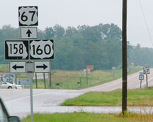
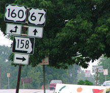
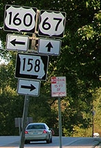
That was looking south on US 67; US 160 began to the right. Today that would be looking south on Road "C", and straight ahead is Road "V". US 160 is still to the right, but now it also goes left for about a quarter-mile, to the new US 67 (and MO 158 has been shortened by the same distance). These shots were looking east on US 160:
|
Sanderson, July 2007
|
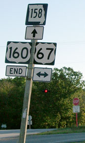
Sanderson, Oct. 2007
|
|
Notice that they did not simply replace the arrow with an "End" panel -- they also replaced the US 160 shield.
Now that US 67 traffic no longer uses the crossroad, and US 160 continues a bit farther ahead, that entire assembly has been replaced: |
Morrison, Oct. 2017
|
|
The overpass for the new US 67 expressway is barely visible in the background, and this image was taken at that point, showing the current east end of US 160:
|
Morrison, Oct. 2017
|
|
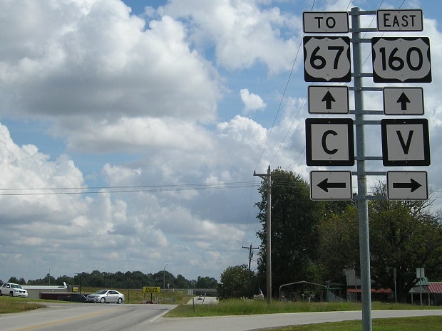
That new segment of US 160 runs along what was formerly MO 158, which now begins straight ahead. Both routes are referenced on exit signage from the new US 67:
|
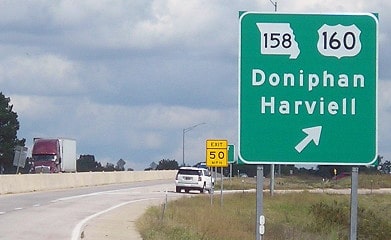
Morrison, Oct. 2017
|
|
That was from northbound US 67; US 160 begins to the west (left). These next shots were taken heading westbound. At the new west end of MO 158, signage references only US 67; there is no indication that US 160 begins straight ahead...
|
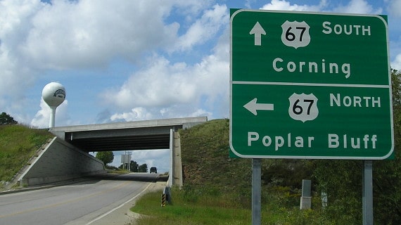
Morrison, Oct. 2017
|
|
...but not far ahead from there, drivers do encounter the first westbound confirming assembly:
|
Morrison, Oct. 2017
|
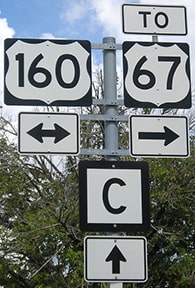
Signage in the distance is for the junction with roads "C" and "V", which formerly carried US 67. The reassurance sign just beyond there was the first westbound confirming assembly until 2017:
|
Sanderson, Oct. 2007
|
|
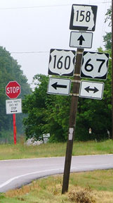
These photos were taken looking north on US 67 (now Road "V", which becomes Rd "C" north of US 160):
|
Sanderson, July 2007
|
Sanderson, Oct. 2007
|
Morrison, Oct. 2017
|
From 1954-2007, to the left was westbound US 160, while eastbound was straight ahead. From 2007-2014, US 160 began to the left. Now US 160 goes both left and right (but it ends a quarter-mile to the right).
|
Research and/or photo credits: Gerald Brown; Andy Field; Scott Maness; Jeff Morrison; Dale Sanderson; Shayne Stephens; Michael Summa
Page originally created 2001;
last updated Dec. 9, 2023.
last updated Dec. 9, 2023.
