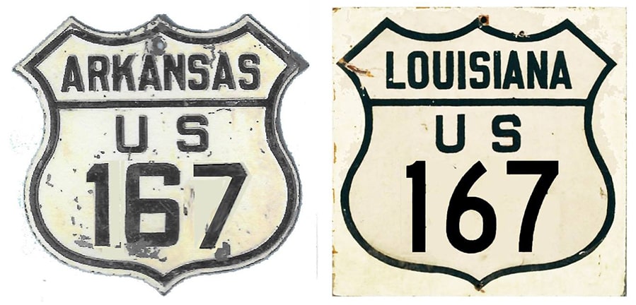
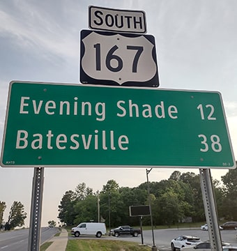
End of US highway 167 |
 |
|
1926-1933?
|
1933?-1948
|
1948-1960
|
1960-1967?
|
1967?-present
|
Summa
|
Mileage: in 1989 AASHTO listed a figure of 499 miles for US 167. That is reasonably close to our own 2020 measurement, which yielded 504.2 miles (reroutings and realignments likely explain the difference). Historically, when it continued to Hardy, US 167 was 514.4 miles long.
|
|
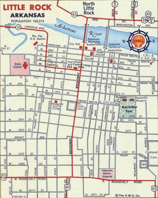
Originally the northern terminus of US 167 was in Little Rock. This map indicates that it junctioned with US 65 at the intersection of 21st and Broadway:
|
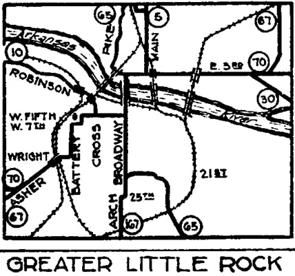
c. 1932, AHTD
|
|
Originally US 167 did not end there; the two routes were overlapped up to Capitol Avenue, in order for US 167 to connect with its implied "parent" route (US 67). This 1958 image was taken looking west on Capitol, and the State Capitol is visible in the distance:
|
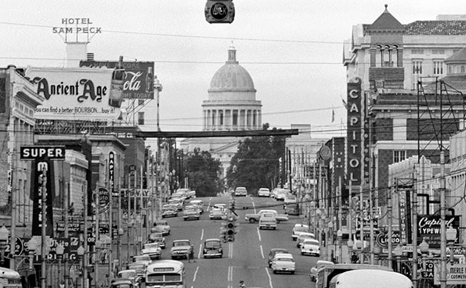
O'Halloran, Sep. 1958 (linked to source)
|
|
Roughly during the time, that direction was westbound US 70/southbound US 67, while eastbound US 70 and northbound US 67-65 were to the right on Broadway. To the left on Broadway was southbound US 65, and it was also the north beginning of US 167. This photo was taken at that intersection, back when US 167 was still signed all the way into the downtown area:
|
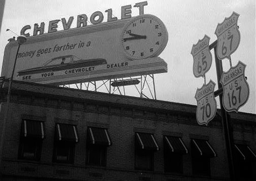
(date and attribution unknown)
|
|
By sometime in the 1950s, US 65, 67, and 70 had all been rerouted along 25th Street (aka Roosevelt Road). US 167 came from the south on Arch Street, and may have ended at Roosevelt (same place where AR hwy. 367 ends today):
|
c. 1956, Gousha
|
|
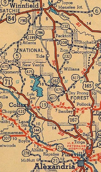
US 167 was among original 1926 routes -- at the time it was routed south of Winnfield on historic LA hwy. 5 (today's LA 34 and 471), and it ended near a locale called "Aloha", which is not far from Colfax. Here is the description from AASHO's Apr. 1927 route log:
|
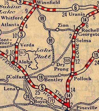
c. 1927, Rand McNally
|
|
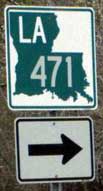
This photo shows signage at the south end of LA 471...
|
Nelson, Feb. 2006
|
...and this photo was taken from northbound US 71...
|
Nelson, Feb. 2006
|
...the original south beginning of US 167 was to the right.
|
In about 1933, US 167 traffic was rerouted south of Winnfield, such that it followed its current corridor to its junction with US 71, just north of Alexandria (AASHO described the location as "Pineville"). Note that, at the time of this map, the original US 167 was still designated LA 5:
c. 1936, Gousha
|
That junction was significantly altered when the interchange at the north end of the Pineville Expressway was built, and the actual intersection no longer exists. But US 71 originally followed what is now LA hwy. 3225 northward out of Alexandria, and where that junctions US 167 is roughly the same spot where US 167 once began. In those days, it was common for routes to overlap into the central area of a nearby city. In this case, that would have been Alexandria, but detailed city insets from that timeframe make no reference to US 167, reflecting the fact that the route actually terminated north of the city:
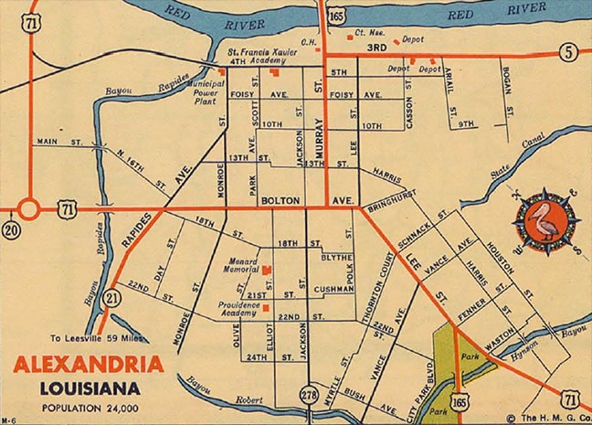
c. 1936, Gousha
|
|
This photo was taken looking north on US 167, just north of where it splits from modern US 71:
|
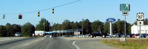
Nitzman, Oct. 2003
|
|
Originally US 71 more-or-less followed today's LA 3225, and straight ahead was once the south beginning of US 167.
In 1948 the south end of US 167 was extended to its current terminus in Abbeville. At the time US 167 ended at its junction with LA hwy. 25... |
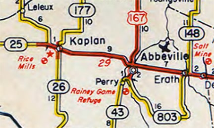
c. 1949, LADoTD
...but in 1955 that was renumbered to LA hwy. 14:
|
c. 1956, Gousha
|
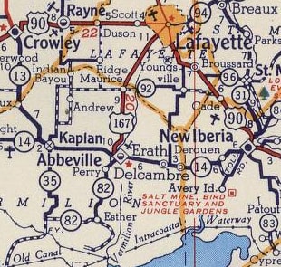
In the mid-1960s the current LA 14 bypass was built along the north edge of Abbeville. For decades it was signed as "LA 14 Bypass" while the original route was signed as "LA 14 Business". However, the "Business" designation did not become official until 2013, which is when LADOTD finally recognized the bypass as mainline LA 14. Regardless, the physical location of US 167's Abbeville terminus has not changed since 1948.
|
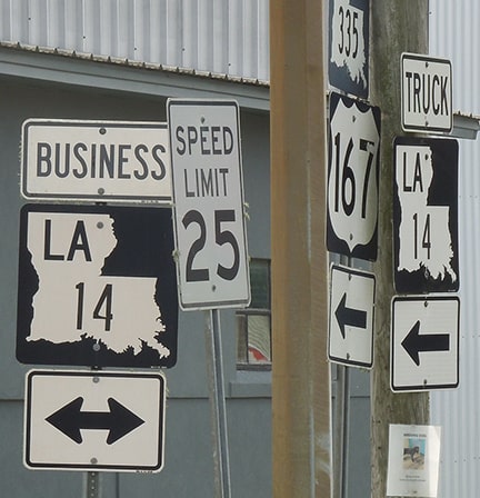
It is somewhat unusual for a US route to end at a state route, and even more so at a state business route. These photos show the south beginning of US 167 as seen from eastbound Business LA 14:
Nitzman, 1999
|
Sanderson, Mar. 2023
|
|
The 167 sign was partially obscured from that vantage point. It can be seen in its entirety from the viewing angle of this next photo on the right-hand side, while on the left side is signage posted for the benefit of drivers who have reached the south end of US 167:
|
Sanderson, Mar. 2023
|
|
This photo was taken looking the opposite direction (west on Business 14), at the right turn northbound onto the beginning of US 167:
|
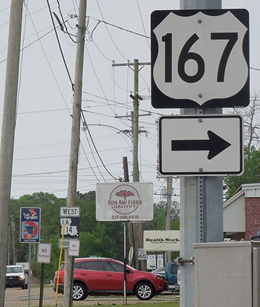
Sanderson, Mar. 2023
|
|
If a driver makes that turn to the right, they are immediately greeted with the first northbound confirming marker:
|
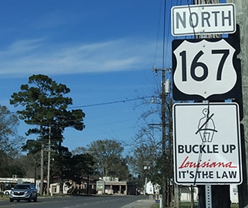
O'Reilly, Jan. 2022
|
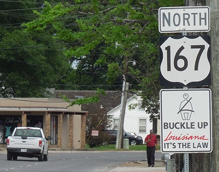
Sanderson, Mar. 2023
|
|
In 1960, the US 167 designation was extended northeast out of Little Rock with US 67 to Bald Knob, then north to US 63 at Hardy:
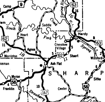
c. 1962, AHTD
|
That map suggests that US 167 actually ended at Ash Flat, and I have yet to see an Arkansas map large-scale enough to show an overlap with US 62 between Hardy and Ash Flat. However, USGS topos from that timeframe do indicate that US 167 extended to Hardy:
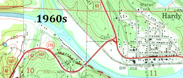
|
|
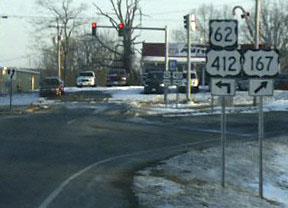
This photo (which was taken prior to the completion of the Hardy bypass) was from eastbound US 62-412, which continued to the right ahead with southbound US 63 (northbound is to the left). Before there was such a thing as US 412, US 167 was overlapped with US 62 to this junction:
|
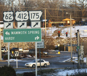
Brooks, Dec. 2004
|
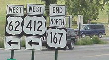
Today it is only Business 63 that is directed to the right, while all of the mainline routes now go to the left, with US 62-412 using the bypass around the north side of Hardy.
|
|
These next photos were taken from the opposite direction: westbound US 62-412 (at this point US 63 traffic has already been directed to turn off onto the bypass, behind the camera). US 62-412 continue to the right, and historically US 167 began to the right as well. That is no longer the case, although a couple references to US 167 are signposted there nonetheless:
|
Turner, Jun. 2023
|
Turner, Jun. 2023
|
Ash Flat is about ten miles to the right; it was probably in about 1967 that the north end of US 167 was truncated to its current terminus in that town:

Brooks, Dec. 2004
Elkins, 2001
|
Turner, Jun. 2023
|
|
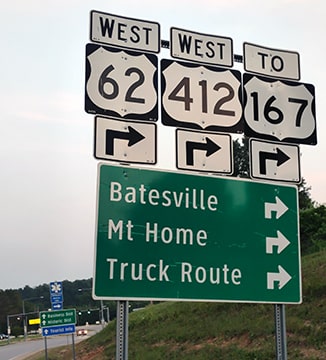
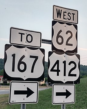
Straight ahead is north via eastbound US 62-412, but historically US 167 extended that direction for another ten miles, to Hardy. These next photos were looking eastbound on US 62-412; those routes continue by turning left, while US 167 begins to the right:
|
Brooks, Dec. 2004
|
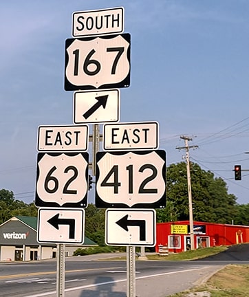
Turner, Jun. 2023
|
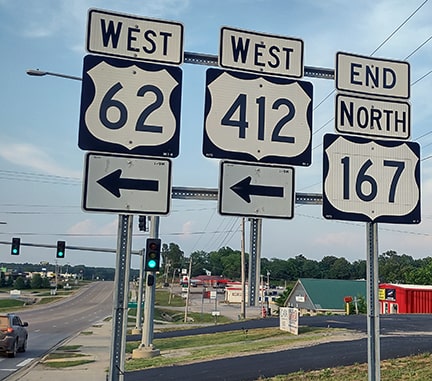
The following photos were all taken from westbound US 62-412; those routes continue by turning right, but straight ahead is the north beginning of US 167:
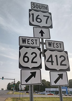
Turner, Jun. 2023
|
Turner, Jun. 2023
|
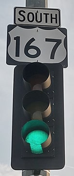
The first southbound confirming marker is mounted on the traffic light pole at the intersection. However, drivers turning onto US 167 from eastbound US 62-412 do not see that sign. So, shown next are the first confirming markers (both historic and current) that are visible to all traffic:
|

Research and/or photo credits: Robert Brooks; H.B. Elkins; Jeremy Lance; Steven Nelson; Alex Nitzman; Thomas O'Halloran; Charlie O'Reilly; Dale Sanderson; Michael Summa; Charles Turner; "Urban Prairie Schooner"
Page originally created 1999;
last updated Feb. 6, 2024.
last updated Feb. 6, 2024.
