US Ends .com
  • Home
  • Store
    • US highway book
    • US highway map
    • Florida US highway map
  • Endpoints
    • US 1 - US 9 >
      • 1 >
        • 201
        • 301
        • 401 [i]
        • 401 [ii]
        • 401
        • 501
        • 601
        • 701
      • 2w >
        • 102
      • 2e >
        • 202
        • 302
      • 3
      • 4 >
        • 104
      • 5
      • 6 >
        • 106
        • 206
      • 7
      • 8
      • 9 >
        • 109*
        • 209
        • 309
    • US 10 - US 19 >
      • 10 >
        • 110
        • 210
        • 310
        • 410
      • 11 >
        • 111
        • 211
        • 311
        • 411 [i]
        • 411 [ii]
        • 411
        • 511*
        • 611
        • 711*
      • 12 >
        • 112
        • 212
        • 312
      • 13 >
        • 113
        • 213
      • 14
      • 15
      • 16 >
        • 116
        • 216
      • 17 >
        • 17-1
        • 117 [i]
        • 117
        • 217
      • 18 >
        • 118
        • 218
      • 19 >
        • 119
        • 219
        • 319
    • US 20 - US 29 >
      • 20e >
        • 120
        • 220
        • 320
        • 420
      • 20w
      • 21 >
        • 121 [i]
        • 121
        • 221
        • 321
        • 421
        • 521
      • 22 >
        • 122 [i]
        • 122 [ii]
        • 222
        • 322
        • 422e
        • 422w
        • 522
        • 622*
      • 23 >
        • 123 [i]
        • 123
        • 223
      • 24 >
        • 124
        • 224
      • 25
      • 26 >
        • 126
      • 27 >
        • 127
        • 227
      • 28
      • 29 >
        • 129
    • US 30 - US 39 >
      • 30 >
        • 130
        • 230
        • 330
        • 430
        • 530
        • 630*
        • 730
        • 830
      • 31 >
        • 131
        • 231
        • 331 [i]
        • 331
        • 431
      • 32
      • 33
      • 34
      • 35
      • 36 >
        • 136
      • 38 >
        • 138
    • US 40 - US 49 >
      • 40 >
        • 140
        • 240
        • 340
      • 41 >
        • 141
        • 241 [i]
        • 241 [ii]
        • 341
        • 441 >
          • 441n
          • 441s
        • 541
        • 641
      • 42
      • 43
      • 44
      • 45
      • 46
      • 48 [i]
      • 48 [ii]
      • 48
      • 49
    • US 50 - US 59 >
      • 50 >
        • 150
        • 250
        • 350
        • 450
        • 550
        • 650
      • 51 - 55 >
        • 51 >
          • 151
        • 52 >
          • 152
        • 53
        • 54 >
          • 154
        • 55
      • 56 >
        • 156
      • 57
      • 58 >
        • 158
        • 258
      • 59 >
        • 159
        • 259
    • US 60 - US 69 >
      • 60 >
        • 160
        • 260
        • 360
        • 460
      • 61 - 65 >
        • 61 >
          • 161
        • 62
        • 63 >
          • 163 [i]
        • 64 >
          • 164 [i]
          • 164 [ii]
          • 264
        • 65 >
          • 165
      • 66 >
        • 166
        • 266
        • 366 [i]
        • 366 [ii]
        • 466 [i]*
        • 466 [ii]
        • 566
        • 666
      • 67 >
        • 167
      • 68 >
        • 168
      • 69 >
        • 169
    • US 70 - US 79 >
      • 70 >
        • 170
        • 270 [i]*
        • 270
        • 370
        • 470
      • 71 >
        • 171
        • 271
        • 371 [i]
        • 371 [ii]
        • 371
      • 72 - 76 >
        • 72
        • 73
        • 74
        • 75 >
          • 175
          • 275
        • 76 >
          • 176
          • 276
      • 77 >
        • 177
        • 277
        • 377
      • 78 >
        • 178
        • 278
        • 378
      • 79
    • US 80 - US 89 >
      • 80 - 84 >
        • 80 >
          • 180 [i]
          • 180
          • 280
          • 380
        • 81 >
          • 181
          • 281
        • 82
        • 83 >
          • 183
          • 283
          • 383
        • 84
      • 85 - 89 >
        • 85 >
          • 185
          • 285 [i]
          • 285
          • 385 [i]
          • 385
          • 485
        • 87 >
          • 187
          • 287n
          • 287s
        • 89n
        • 89s >
          • 189 [i]
          • 189
    • US 90 - US 99 >
      • 90 - 94 >
        • 90 >
          • 190
          • 290
        • 91 >
          • 191 >
            • 191n
            • 191s
          • 491
        • 92 >
          • 192
        • 93
        • 94
      • 95 -98 >
        • 95 >
          • 195
          • 295
          • 395
        • 96 [i]
        • 96
        • 97 >
          • 197
        • 98
      • 99 >
        • 199
        • 299
        • 399
    • Anomalies >
      • 101
      • 163
      • 400
      • 412
      • 425
  • Places
    • A-L >
      • A >
        • Aberdeen
        • Albuquerque
        • Amarillo
        • Apalachicola
        • Astoria
        • Atlantic
      • B >
        • Baltimore
        • Baton Rouge
        • Bay Area
        • Bishop
        • Boone
        • Brady
        • Bristol
        • Brownsville
        • Brunswick
      • C >
        • Charleston
        • Chattanooga
        • Chicago
        • Cincinnati
        • Cleveland
        • Cody
        • Corpus
        • Cortez
        • Council Bluffs
        • Covington
        • Crescent
        • Cumberland Gap
      • D-E >
        • Dallas
        • Des Moines
        • Detroit
        • Dothan
        • Douglas
        • El Paso
        • Erie
        • Eugene
      • F >
        • Farmington
        • Flagstaff
        • Florence
        • Fox Valley
        • Franklin
      • G >
        • Gallup
        • Georgetown
        • Grand Junction
        • Grand Portage
        • Grayling
        • Great Falls
        • Greeley
      • H-I >
        • Hardeeville
        • Harrisburg
        • Holbrook
        • Idaho Falls
        • Int'l Falls
      • J-K >
        • Jacksonville
        • Joplin
        • Junction
        • Kansas City
        • Keokuk
        • Key West
        • Kingman
      • L >
        • Laredo
        • Lewiston
        • Long Beach
        • Los Angeles
        • Louisville
        • Lubbock
    • M-R >
      • M >
        • Mackinaw
        • Madison
        • Maryhill
        • Maysville
        • Miami
        • Midway
        • Miles City
        • Milford
        • Milwaukee
        • Minneapolis
        • Mobile 31
        • Mobile 31-43-45
        • Montgomery
        • Monticello
        • Mount Vernon
      • N-O >
        • Nags Head
        • Naples
        • Natchez
        • New Castle
        • New Orleans
        • Niagara
        • Norlina
        • Ocean City
        • Oklahoma City
      • P >
        • Pee Dee
        • Pembina
        • Pensacola
        • Petersburg
        • Philadelphia
        • Piegan
        • Pineville
        • Port Arthur
        • Portsmouth
      • Q-R >
        • Quad Cities
        • Rapid City
        • Raton
        • Reading
        • Richmond
        • Rockingham
        • Rouses Point
    • S-Z >
      • S >
        • San Antonio
        • San Antonio NM
        • San Diego
        • Santa Fe
        • Savannah
        • Sioux
        • Springer
        • Springfield
        • St. Ignace
        • St. John
        • St. Paul
        • St. Pete
      • T-U-V >
        • Tallahassee
        • Tampa
        • Toledo
        • Trinidad
        • Tuba City
        • Ucolo
        • VA Beach
      • W >
        • Walterboro
        • Waverly
        • West Memphis
        • Wilmington
        • Wilson
        • Wrightsville
      • Y >
        • Yellowstone E
        • Yellowstone N
        • Yellowstone NE
        • Yellowstone S
        • Yellowstone W
  • Highways
    • Map of all endpoints
    • Sources
    • History
    • 1926 almost-routes
    • Intra-state routes
    • Numbering
    • Colors
    • Gaps
    • Blog
  • Bonus
    • Colorado >
      • Lowest point
      • Antipodes
      • Toponymy >
        • Roots
      • Colloquialisms
      • Populations
      • Denvers
    • Washington Meridian
    • Watersheds >
      • Headwaters Hill
      • Three Waters Mtn.
      • Parting of the Waters
    • Geo-centers >
      • 48 states
      • 50 states
      • North America
    • State corners >
      • AZ-CO-NM-UT
      • CO-UT-WY
      • CO-NE-WY
      • CO northeast
      • CO-KS-NE
      • CO-KS-OK
      • CO-NM-OK
      • NM-OK-TX
      • NM southeast
      • TX northwest
  • Connect
    • Author/history
    • Rationale
    • Contact
    • Contributors
    • Submissions

US highway endpoints at Moran Junction and Yellowstone's south entrance

1936-present
Get your very own map showing all current and historic US routes!

Among roadfans, it is widely-known that US routes are not signed through Yellowstone National Park, and the south entrance to the Park is commonly cited as the southern point of interruption for several routes.  That may have been true in the past, but today the highway is actually not signposted anywhere north of Moran Junction (which is in Grand Teton National Park, about 30 miles south of the Yellowstone park boundary).  Furthermore -- although the north end of US 187 was always at an intersection known as "Moran" or "Moran Junction" -- the specific location of that intersection was formerly about five miles to the north and west of the current junction.  Today, highway traffic coming north from Jackson goes through Moran Jct. (on the right side of this map)...
Picture
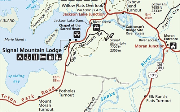
c. 2011, National Park Service
...but prior to 1957, highway traffic used what is now known as "Teton Park Road", and the highway intersection was at what is now called "Jackson Lake Jct" (towards the top of the map).  However, today's "Jackson Lake Jct." was referred to as "Moran Jct." up until the time that the current junction was established.  
Get your copy of this epic book that commemorates the first century of the US route system!

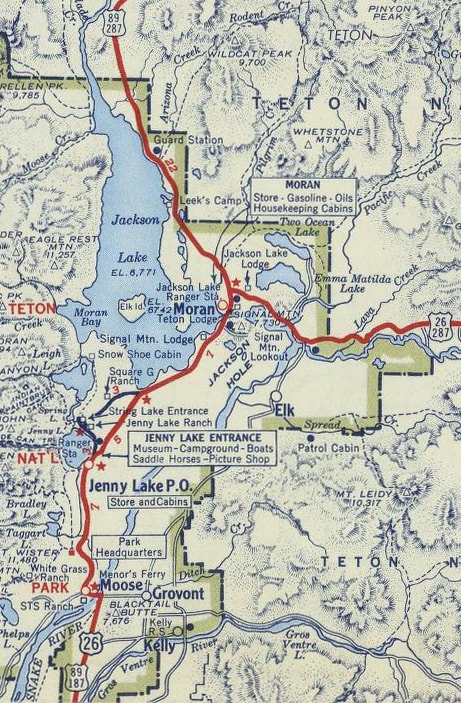
​This map shows that highway traffic formerly crossed the Snake River at Moose, and then continued up past Jenny Lake and Jackson Lake to a highway junction labeled "Moran".  At the time, the road running along the east bank of the Snake River was not paved:
Picture
c. 1937, Rand McNally
By the time of this next map, the US 89 designation had been extended through the area, but the road through "Elk" was still not paved, and there was nothing at the location of today's Moran Jct. except for the Buffalo Ranger Station:
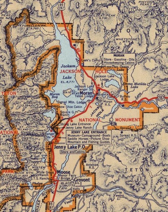
Picture
c. 1947, Gousha
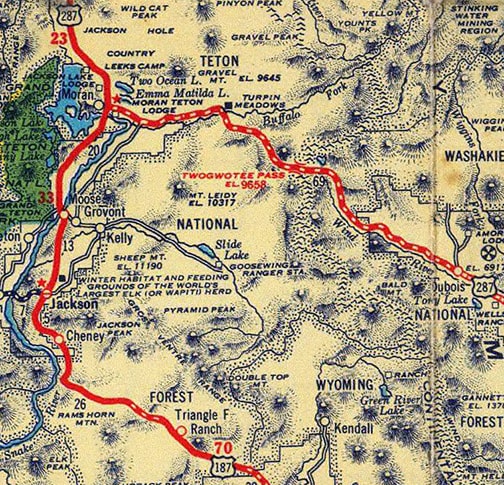
Within a few more years, the US 26 designation had been added to the mix, but highway traffic was still using the original road past Jenny Lake:
Picture
c. 1951, Gousha
This photo was taken at Jackson Lake Jct. (nee Moran Jct.) from the perspective of what was originally northbound US 87W, but which later became US 287 (and is now US 89 and US 191 as well).  US 187 began to the left:
Picture
Elbert, July 2005
​The photo below shows that same sign, but from the perspective of a driver at the original north end of US 187:
Picture
Elbert, July 2005
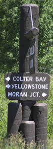
That was the original "Moran Jct", but note that today drivers looking for Moran Jct. are directed to the east.  It was about 1957 when US 187 (which by then was also US 26 and US 89) was rerouted to the present highway along the east bank of the Snake River.  After that, it met US 287 at the current Moran Jct. and ended there.  The moniker "Moran Jct." was applied to the new intersection, and the old intersection was renamed to "Jackson Lake Jct".  This photo was taken at the modern junction:
Picture
Elbert, July 2005
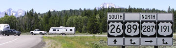
In the background, part of the Teton Range is visible.  That was coming from Dubois on northbound US 287/westbound US 26 (straight ahead leads south to Jackson via southbound US 89 and US 191, but technically that should be "West" on US 26, not "South").  Straight ahead was also the north beginning of US 187 from the 1957 until 1982.  For travelers turning to the right, no routes are posted until the far side of Yellowstone.  (Although at the Colter Bay Visitor Center -- which is about a mile off the main highway -- there was a sign with the text "To US 89", but US 191/287 were not referenced.)  Also, there was no directional signage for a driver heading south there (such as the white pickup in the background), which is a remarkable oversight.  The photo below is looking the opposite direction -- north on what is now eastbound US 26/northbound US 89/US 191:
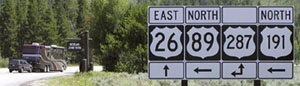
Picture
Elbert, July 2005
US 26 continues ahead (with southbound US 287) over Togwotee Pass towards Dubois.  Northbound US 89-191-287 goes left to Yellowstone's south entrance (although there were no more signs beyond that one).  Pre-1982, things were the same at this junction, except US 187 ended here, and US 191 did not run through these parts.  In 1982, US 187 was decommissioned, because US 191 was extended southward via an implied route through Yellowstone National Park, swallowing up the entirety of what had been US 187.  To the left, the road travels through 21 more miles of Grand Teton NP.  Then there is an 8-mile stretch through a sort of buffer protection zone known as the John D. Rockerfeller, Jr. Memorial Parkway.  After that, one reaches the Yellowstone park boundary...
Picture
Elbert, July 2005
​...and the historic interruption point for US 89, 191, and 287 (and before 1965, that was actually the north endpoint of US 287).  Today both US 287 and US 191 resume at West Yellowstone, while US 89 reappears at the Park's north entrance.
main US 89 page
main US 187 page
main US 191 page
main US 287 page
Research and/or photo credits: Chris Elbert; Dale Sanderson
Page originally created 2005;
last updated Nov. 10, 2016.
Copyright © 1998-2025
Picture