US Ends .com
  • Home
  • Store
    • US highway book
    • US highway map
    • Florida US highway map
  • Endpoints
    • US 1 - US 9 >
      • 1 >
        • 201
        • 301
        • 401 [i]
        • 401 [ii]
        • 401
        • 501
        • 601
        • 701
      • 2w >
        • 102
      • 2e >
        • 202
        • 302
      • 3
      • 4 >
        • 104
      • 5
      • 6 >
        • 106
        • 206
      • 7
      • 8
      • 9 >
        • 109*
        • 209
        • 309
    • US 10 - US 19 >
      • 10 >
        • 110
        • 210
        • 310
        • 410
      • 11 >
        • 111
        • 211
        • 311
        • 411 [i]
        • 411 [ii]
        • 411
        • 511*
        • 611
        • 711*
      • 12 >
        • 112
        • 212
        • 312
      • 13 >
        • 113
        • 213
      • 14
      • 15
      • 16 >
        • 116
        • 216
      • 17 >
        • 17-1
        • 117 [i]
        • 117
        • 217
      • 18 >
        • 118
        • 218
      • 19 >
        • 119
        • 219
        • 319
    • US 20 - US 29 >
      • 20e >
        • 120
        • 220
        • 320
        • 420
      • 20w
      • 21 >
        • 121 [i]
        • 121
        • 221
        • 321
        • 421
        • 521
      • 22 >
        • 122 [i]
        • 122 [ii]
        • 222
        • 322
        • 422e
        • 422w
        • 522
        • 622*
      • 23 >
        • 123 [i]
        • 123
        • 223
      • 24 >
        • 124
        • 224
      • 25
      • 26 >
        • 126
      • 27 >
        • 127
        • 227
      • 28
      • 29 >
        • 129
    • US 30 - US 39 >
      • 30 >
        • 130
        • 230
        • 330
        • 430
        • 530
        • 630*
        • 730
        • 830
      • 31 >
        • 131
        • 231
        • 331 [i]
        • 331
        • 431
      • 32
      • 33
      • 34
      • 35
      • 36 >
        • 136
      • 38 >
        • 138
    • US 40 - US 49 >
      • 40 >
        • 140
        • 240
        • 340
      • 41 >
        • 141
        • 241 [i]
        • 241 [ii]
        • 341
        • 441 >
          • 441n
          • 441s
        • 541
        • 641
      • 42
      • 43
      • 44
      • 45
      • 46
      • 48 [i]
      • 48 [ii]
      • 48
      • 49
    • US 50 - US 59 >
      • 50 >
        • 150
        • 250
        • 350
        • 450
        • 550
        • 650
      • 51 - 55 >
        • 51 >
          • 151
        • 52 >
          • 152
        • 53
        • 54 >
          • 154
        • 55
      • 56 >
        • 156
      • 57
      • 58 >
        • 158
        • 258
      • 59 >
        • 159
        • 259
    • US 60 - US 69 >
      • 60 >
        • 160
        • 260
        • 360
        • 460
      • 61 - 65 >
        • 61 >
          • 161
        • 62
        • 63 >
          • 163 [i]
        • 64 >
          • 164 [i]
          • 164 [ii]
          • 264
        • 65 >
          • 165
      • 66 >
        • 166
        • 266
        • 366 [i]
        • 366 [ii]
        • 466 [i]*
        • 466 [ii]
        • 566
        • 666
      • 67 >
        • 167
      • 68 >
        • 168
      • 69 >
        • 169
    • US 70 - US 79 >
      • 70 >
        • 170
        • 270 [i]*
        • 270
        • 370
        • 470
      • 71 >
        • 171
        • 271
        • 371 [i]
        • 371 [ii]
        • 371
      • 72 - 76 >
        • 72
        • 73
        • 74
        • 75 >
          • 175
          • 275
        • 76 >
          • 176
          • 276
      • 77 >
        • 177
        • 277
        • 377
      • 78 >
        • 178
        • 278
        • 378
      • 79
    • US 80 - US 89 >
      • 80 - 84 >
        • 80 >
          • 180 [i]
          • 180
          • 280
          • 380
        • 81 >
          • 181
          • 281
        • 82
        • 83 >
          • 183
          • 283
          • 383
        • 84
      • 85 - 89 >
        • 85 >
          • 185
          • 285 [i]
          • 285
          • 385 [i]
          • 385
          • 485
        • 87 >
          • 187
          • 287n
          • 287s
        • 89n
        • 89s >
          • 189 [i]
          • 189
    • US 90 - US 99 >
      • 90 - 94 >
        • 90 >
          • 190
          • 290
        • 91 >
          • 191 >
            • 191n
            • 191s
          • 491
        • 92 >
          • 192
        • 93
        • 94
      • 95 -98 >
        • 95 >
          • 195
          • 295
          • 395
        • 96 [i]
        • 96
        • 97 >
          • 197
        • 98
      • 99 >
        • 199
        • 299
        • 399
    • Anomalies >
      • 101
      • 163
      • 400
      • 412
      • 425
  • Places
    • A-L >
      • A >
        • Aberdeen
        • Albuquerque
        • Amarillo
        • Apalachicola
        • Astoria
        • Atlantic
      • B >
        • Baltimore
        • Baton Rouge
        • Bay Area
        • Bishop
        • Boone
        • Brady
        • Bristol
        • Brownsville
        • Brunswick
      • C >
        • Charleston
        • Chattanooga
        • Chicago
        • Cincinnati
        • Cleveland
        • Cody
        • Corpus
        • Cortez
        • Council Bluffs
        • Covington
        • Crescent
        • Cumberland Gap
      • D-E >
        • Dallas
        • Des Moines
        • Detroit
        • Dothan
        • Douglas
        • El Paso
        • Erie
        • Eugene
      • F >
        • Farmington
        • Flagstaff
        • Florence
        • Fox Valley
        • Franklin
      • G >
        • Gallup
        • Georgetown
        • Grand Junction
        • Grand Portage
        • Grayling
        • Great Falls
        • Greeley
      • H-I >
        • Hardeeville
        • Harrisburg
        • Holbrook
        • Idaho Falls
        • Int'l Falls
      • J-K >
        • Jacksonville
        • Joplin
        • Junction
        • Kansas City
        • Keokuk
        • Key West
        • Kingman
      • L >
        • Laredo
        • Lewiston
        • Long Beach
        • Los Angeles
        • Louisville
        • Lubbock
    • M-R >
      • M >
        • Mackinaw
        • Madison
        • Maryhill
        • Maysville
        • Miami
        • Midway
        • Miles City
        • Milford
        • Milwaukee
        • Minneapolis
        • Mobile 31
        • Mobile 31-43-45
        • Montgomery
        • Monticello
        • Mount Vernon
      • N-O >
        • Nags Head
        • Naples
        • Natchez
        • New Castle
        • New Orleans
        • Niagara
        • Norlina
        • Ocean City
        • Oklahoma City
      • P >
        • Pee Dee
        • Pembina
        • Pensacola
        • Petersburg
        • Philadelphia
        • Piegan
        • Pineville
        • Port Arthur
        • Portsmouth
      • Q-R >
        • Quad Cities
        • Rapid City
        • Raton
        • Reading
        • Richmond
        • Rockingham
        • Rouses Point
    • S-Z >
      • S >
        • San Antonio
        • San Antonio NM
        • San Diego
        • Santa Fe
        • Savannah
        • Sioux
        • Springer
        • Springfield
        • St. Ignace
        • St. John
        • St. Paul
        • St. Pete
      • T-U-V >
        • Tallahassee
        • Tampa
        • Toledo
        • Trinidad
        • Tuba City
        • Ucolo
        • VA Beach
      • W >
        • Walterboro
        • Waverly
        • West Memphis
        • Wilmington
        • Wilson
        • Wrightsville
      • Y >
        • Yellowstone E
        • Yellowstone N
        • Yellowstone NE
        • Yellowstone S
        • Yellowstone W
  • Highways
    • Map of all endpoints
    • Sources
    • History
    • 1926 almost-routes
    • Intra-state routes
    • Numbering
    • Colors
    • Gaps
    • Blog
  • Bonus
    • Colorado >
      • Lowest point
      • Antipodes
      • Toponymy >
        • Roots
      • Colloquialisms
      • Populations
      • Denvers
    • Washington Meridian
    • Watersheds >
      • Headwaters Hill
      • Three Waters Mtn.
      • Parting of the Waters
    • Geo-centers >
      • 48 states
      • 50 states
      • North America
    • State corners >
      • AZ-CO-NM-UT
      • CO-UT-WY
      • CO-NE-WY
      • CO northeast
      • CO-KS-NE
      • CO-KS-OK
      • CO-NM-OK
      • NM-OK-TX
      • NM southeast
      • TX northwest
  • Connect
    • Author/history
    • Rationale
    • Contact
    • Contributors
    • Submissions

Historic US highway endpoints in Harrisburg, PA

1927-1966
Get your very own map showing all current and historic US routes!

Although no US highways terminate in Harrisburg today, historically four different routes have ended in the area.  Three of them were shown by the time of this 1930 map:
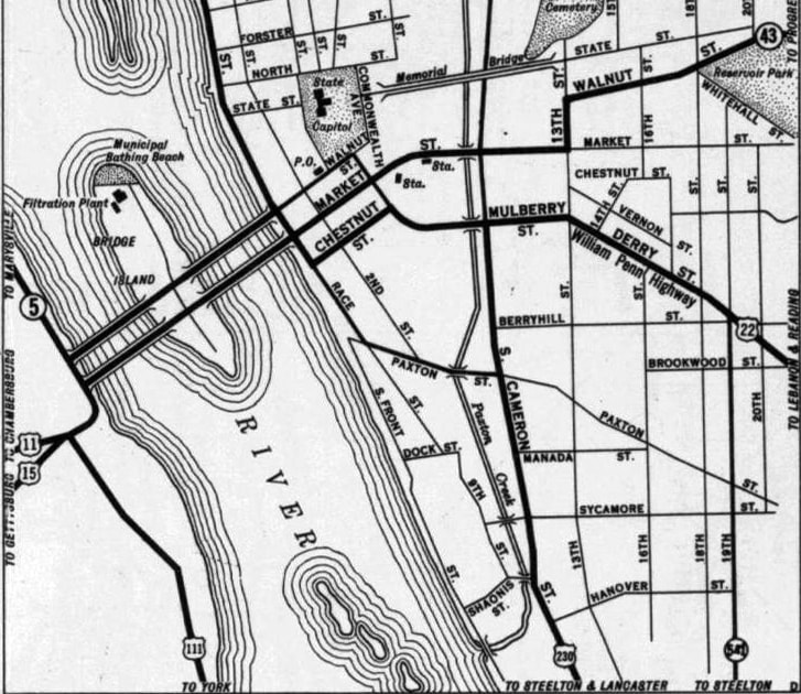
Picture
c. 1930, PennDoT
The north half of that map is cropped, but the thick black line at upper left (running along the east bank of the river) was labeled North Front Street, and was shown to carry US 11-22 traffic.  The last shield for US 230 is at lower center, and the last shields for US 15 and US 111 are shown in the lower left.  (However, the state map on the reverse side of that map showed that US 111 had a northern segment, running between US 11 at Northumberland and the New York state line at Lawrenceville.)
In 1936, US 15 was extended north, replacing the north segment of US 111 to Lawrenceville.  After that time, US 111's north end was always at its junction with its parent route (US 11) on the west bank of the river; it never crossed into Harrisburg.  Originally US 11 ran along Market Street, while US 15 came in on State Street.  These two routes converged near 5th Street, and then crossed the river together into Harrisburg.  US 111 came in on 3rd Street/Bridge Street, and ended at Market.  ​This photo is looking east on Market:
Picture
(attribution unknown)
That was northbound US 11-15, and for a time, US 111 began to the right on 3rd.  Meanwhile, the US 15 designation did not continue much farther: it probably ended right where the Market St. Bridge landed in Harrisburg, at Front Street (labeled Race Street on the map above):
Picture
xirtam, Sep. 2004
Get your copy of this epic book that commemorates the first century of the US route system!

That is the location of the Dauphin County Courthouse, and in the early years of the US route system it was common to sign routes all the way to a prominent government building.  There, US 15 would have junctioned US 22, and also shared a common terminus with US 230.  This interactive image is looking east on Market at Front:
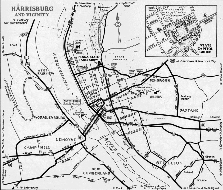
The cross street is Front, which at the time carried US 22 traffic.  So that intersection was most likely the north end of US 15, while the west beginning of US 230 was to the right on Front (overlapping with US 22 for a few blocks).  And just a couple years later, US 422 also began to the right; its route is shown on this 1940 map:
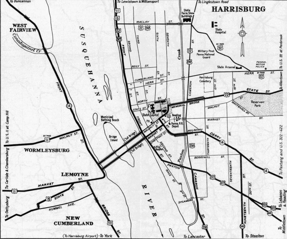
Picture
c. 1940, PennDoT
However, by the time of that map, US 15 no longer ended in Harrisburg.  Despite the US 11 bypass in Lemoyne, US 111 probably still retained its original endpoint.  However, the US 230 designation had been extended such that it stayed on Cameron Street, then turned west on Maclay Street, ending at Front.  This photo is looking south on Front.
Picture
Sanderson, Nov. 2000
​US 230 began to the left, on Maclay.  That was still the case by the time of the 1950 map shown below, but other things had changed:
Picture
c. 1950, PennDoT
For one thing, US 22 had a bifurcated route around opposite sides of the Pennsylvania State Capitol (although it is unclear whether this change would have caused the US 422 designation to be extended to North Street).  US 11-15 no longer crossed to the east bank of the river to join with US 22-322.  Instead, US 11-15 stayed along the west bank.  Also, what had started out as US 11 Bypass along Cumberland Boulevard and Walnut Street was now mainline US 11, while the original route along Market was changed to Alternate US 11.  At some point, the US 111 designation was extended along Front Street, ending at the new US 11 (Walnut).  While not shown explicitly on the map above, it is clear that had happened by the time of the 1960 map below:
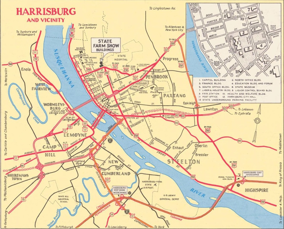
Picture
c. 1960, PennDoT
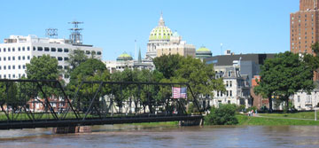
In this photo, downtown Harrisburg and the Capitol building are visible on the far side of the Susquehanna.  This is in Wormleysburg, facing northeast on Walnut Street where it ends at Front Street:
Picture
Sanderson, Nov. 2000
Picture
(detail)
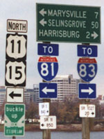
Northbound US 11-15 comes down Walnut to this spot, and then turns left on Front.  Before 1961, drivers turning to the right there would have been on the north beginning of US 111.  This photo was taken from what used to be the north end of US 111:
Picture
Sanderson, Nov. 2000
That was heading northwest on Front; Walnut is the light ahead.  Also shown on the map above is a different route for US 22 traffic, along Forster Street.  When that change was made, the US 422 designation was probably extended north on Front, in order to maintain a junction with its parent route (even though that is not shown on the Capitol area inset at upper right).  This photo was looking south on Front Street:
Picture
Sanderson, Nov. 2000
The Harvey Taylor Bridge is visible on the right; it aligns with Forster on the Harrisburg side of the river (left).  US 22-322 was here on Front; at Forster US 22 turned left, while US 322 continued straight ahead.  That also would have been the west beginning of US 422 for a time.
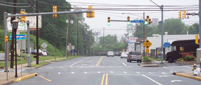
A couple remaining changes took place after that 1960 map.  US 230 was truncated such that it ended on Cameron at Maclay/Arsenal Boulevard.  This photo was looking north on Cameron:
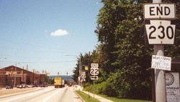
Picture
Nitzman, 2000
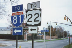
The traffic light is Maclay to the left, Arsenal to the right.  US 230 ended here from 1961 until its decommissioning in 1966.  By the time of the 1970 state map, US 230 had been decommissioned, and instead it was PA 230 that ended at that intersection.  Also, when the future I-83 was being built, the US 111 designation was changed to follow the new freeway.  At first, US 111 exited at 3rd in Lemoyne and continued following its old route up to Wormleysburg.  But for a period of two years, US 111 was extended east and north along I-83, to end at the US 22 interchange (exit 50).  This photo was looking eastbound on US 22:
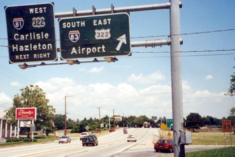
Picture
Nitzman, July 2000
​The north beginning of US 111 was to the right (with I-83 and eastbound 322) from 1961-1963; then US 111 was decommissioned.  And by the time of the 1970 map, US 422 had been truncated to its current west terminus in Hershey, so today no US routes end in Harrisburg.
main US 15 page
main US 111 page
main US 230 page
main US 422 page
Research and/or photo credits: Jeff Kitsko; Alex Nitzman; Dale Sanderson; "xirtam"​
Page originally created 2000;
last updated Jan. 24, 2019.
Copyright © 1998-2025
Picture