Historic US highway endpoint in Long Beach, CA
|
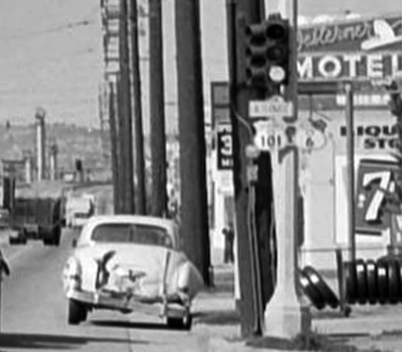
During the quarter-century when US 6 went all the way to the Pacific Ocean, "westbound" travelers actually got only as far west as the San Fernando Valley. From there, the route was overlapped along with US 99 back southeast to downtown Los Angeles. There those two designations diverged, and US 6 traffic was routed southward via Figueroa Street. At Pacific Coast Highway (which was known as "State Street" until sometime in the 1940s), drivers were directed east (along with southbound US 101A), towards downtown Long Beach. That's right: travelers at the western terminus of US 6 were actually heading due east. While that was an unusual (but not entirely unique) situation, it is even more interesting when one considers that, some 3600 miles to the east, travelers at the east end of US 6 were actually heading west around the spiral of Cape Cod.
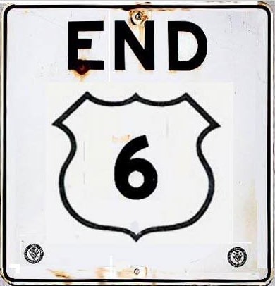
So where exactly in Long Beach did US 6 end? Where was this sign posted? |
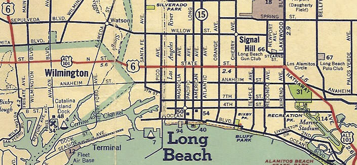
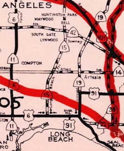
It is clear that US 6 came down Figueroa (upper left) and then joined with US 101A eastward at least to Santa Fe Avenue. But that is the last US 6 marker on the map, so it is not obvious where the designation ended. Various online sources list at least five different Long Beach intersections that supposedly marked the historic endpoints of US 6. Some of them claim that US 6 ended at the Los Alamitos traffic circle (at right, where State intersects Lakewood Boulevard, Ximeno Avenue, and Hathaway Avenue). Although I have never seen a map with a US 6 marker further east than Atlantic Avenue, some people have informed me that they seem to recall US 6, US 91, and US 101 all being signed at Los Alamitos Circle. Be that as it may, at some point the Long Beach endpoint of US 6 was on State at Atlantic. That arrangement was illustrated on this map:
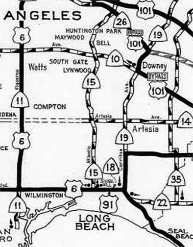
That map strongly suggests that US 6 ended at its junction with CA hwy. 15, or Atlantic. By this time, US 91 had also been extended into Long Beach (note that old "State Street" was now known as "Pacific Coast Hy"), and that map seems quite clear that designation was signed westward on PCH to the same intersection. That is not the only map that corroborates the Atlantic Av endpoint; the one below was produced by Caltrans. The intersection of PCH and Atlantic has three dots with arrows, meaning three routes began there: US 6 to the west, CA 15 to the north, and US 91 to the east:
|
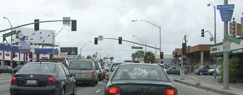
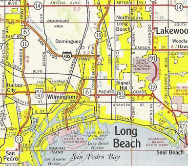
That second map shows the same area, about a decade later. By then the CA 15 designation had been moved off Atlantic and onto the Long Beach Freeway; and the terminus points for US 6 and US 91 had been shifted accordingly. More on that below, but first, here is a modern photo from the Atlantic endpoint:
|
|
That was looking west on PCH at Atlantic; for many years this was northbound US 101A. At one point, this would have been the south end of US 91. The west beginning of US 6 was straight ahead, and CA 15 began to the right.
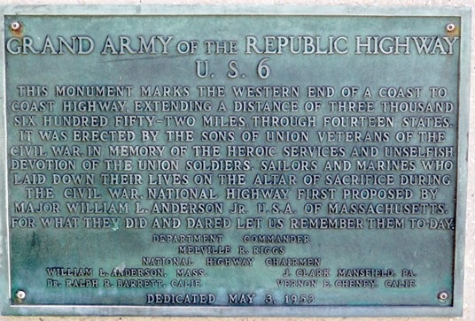
Note that the map above does not indicate any signed highway south of PCH. That is significant, because some have suggested that US 6 was formerly signed south from PCH on Long Beach Boulevard, ending at Seaside Boulevard. This notion appears to arise from the fact that the original location of the bronze US 6 plaque shown here was at the historic Municipal Auditorium:
|
The auditorium was indeed situated at Long Beach and Seaside. However, it does not necessarily follow that US 6 was ever officially signed to the location of this plaque. In fact, this sentence from the Route 6 Tour website appears to back that up:
"[In 1953] ...the Long Beach City Council authorized the placing of temporary U.S. Route 6 signs along Long Beach Blvd. in order to direct [Grand Army of the Republic] encampment traffic to the Auditorium."
Obviously it is not the city council's job to sign state highway routes. If US 6 had been officially extended down Long Beach Blvd, then it would not have been necessary for the city council to take any action, and the signs would not have been "temporary". So, despite the plaque's location at the Municipal Auditorium, there does not appear to be any evidence that US 6 itself was actually located there.
Apparently the auditorium was torn down in the 1960s, and the bronze plaque was moved to its current location at the Long Beach Performing Arts Center (which was then known as the Terrace Theater). Again, this has led some to conclude that US 6 once ended at the location of this venue (Long Beach Blvd and Ocean Blvd). But, as with the old auditorium, that is not necessarily true. Actually, it is more likely that these two buildings were simply appropriate public locations on which to mount the plaque, but their locations had no bearing on the actual routing of US 6.
|
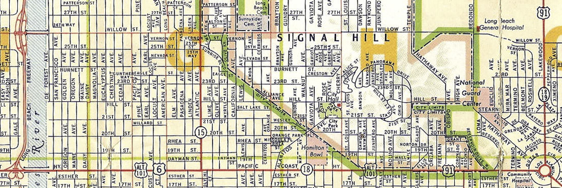
The Gousha map above shows the Long Beach Freeway at far left. As mentioned earlier: at some point after that was completed and the CA 15 designation was changed from Atlantic to the LBF, the US 6 designation was cut back a bit, such that it ended on PCH at its interchange with the LBF. Likewise, the US 91 designation was extended by the same amount, such that it also ended on PCH at the LBF interchange. This 1961 map was made when that was the case:
|
|
Steve recalls a sign eastbound on Pacific Coast Highway at the Long Beach Freeway marking "END US 6." This photo was taken looking the opposite direction (west on PCH) at Harbor Avenue (which is just west of LBF), so the US 6 shield shown here was almost certainly the first confirming marker:
|
Steve also recalls that during the 1950s and '60s, US 6 was signed east/west throughout the state (despite its generally north/south direction), and that this was a continual source of complaints to the highway department. The situation was particularly confusing in the area shown on these maps, approaching Long Beach: travelers heading east would see signs posted "West US 6" and "South US 101A".
|
That exit to southbound PCH was the south beginning of US 91 for a few years. Continuing straight ahead under the overpass, the cloverleaf to northbound PCH was the west beginning of US 6. At any rate, it was not long before both routes were significantly shortened: US 6 was truncated to its current terminus in Bishop CA; here is that agenda item from AASHO's June 1963 meeting minutes:
|
Similarly, US 91 was cut back to Barstow for a few years before it was completely eliminated from California, Nevada, and most of Utah. At about the same time, the south end of US 101 was changed to downtown Los Angeles, and since then Long Beach has not been served by any US route.
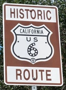
The historic route of US 6 is beginning to be recognized in California, much like historic US 66, US 99, and other routes that were decommissioned in the 1960s. Heading "east" from Long Beach (which is really more north and west at first), the first historic sign was posted where the Sierra Highway enters the Santa Clarita city limits:
|
Research and/or photo credits: Nathan Edgars; Chris Elbert; Andy Field; Karin and Martin Karner; Alex Nitzman; Steve Riner; Mike Roberson; Dale Sanderson; Michael Summa
Page originally created 2005;
last updated Jan. 28, 2022.
last updated Jan. 28, 2022.
