End of US highway 10 |
 |
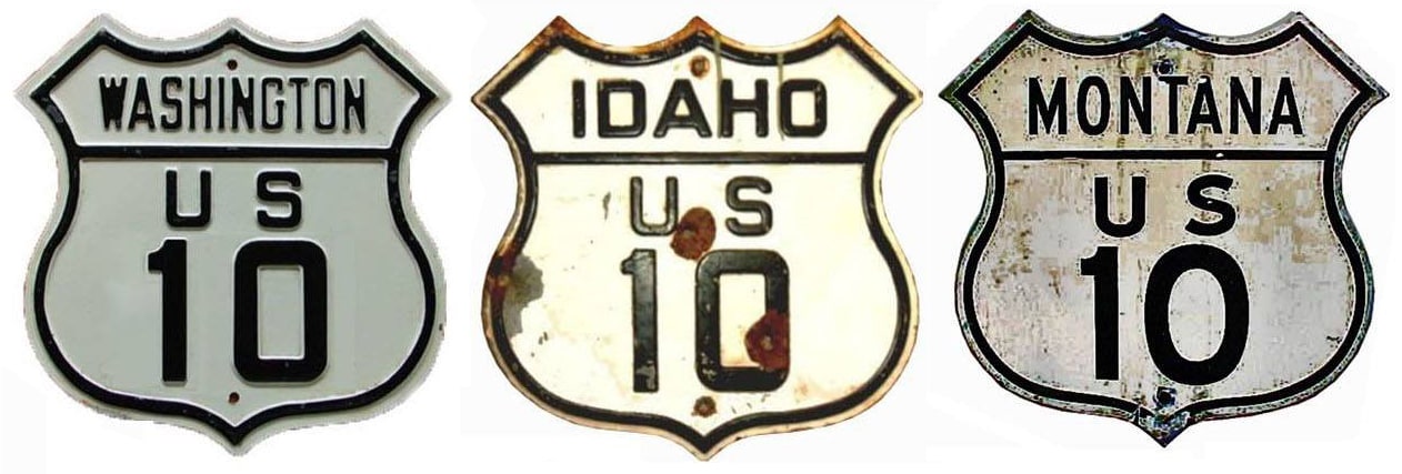
Summa
|
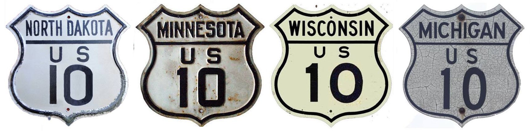
Summa
|
|
1926-1969
|
1969-1986
|
1986-present
|
Mileage: in 1989 AASHTO listed a figure of 710 miles for US 10... however, that included the mileage of US 10's associated business route. According to the state subtotals on AASHTO's 1989 spreadsheet, mainline US 10's actual end-to-end total at the time was 706 miles. That is reasonably close to our own 2020 measurement, which yielded 713.3 miles (reroutings and realignments likely explain the difference). Historically, US 10 was among the longest US routes, measuring 2128 miles (note that none of those figures include the 60-mile car ferry trip between Michigan and Wisconsin).
|
Claim to fame: US 10 is one of only two existing US highways whose route still includes a ferry segment (the other is US 9).
|
|
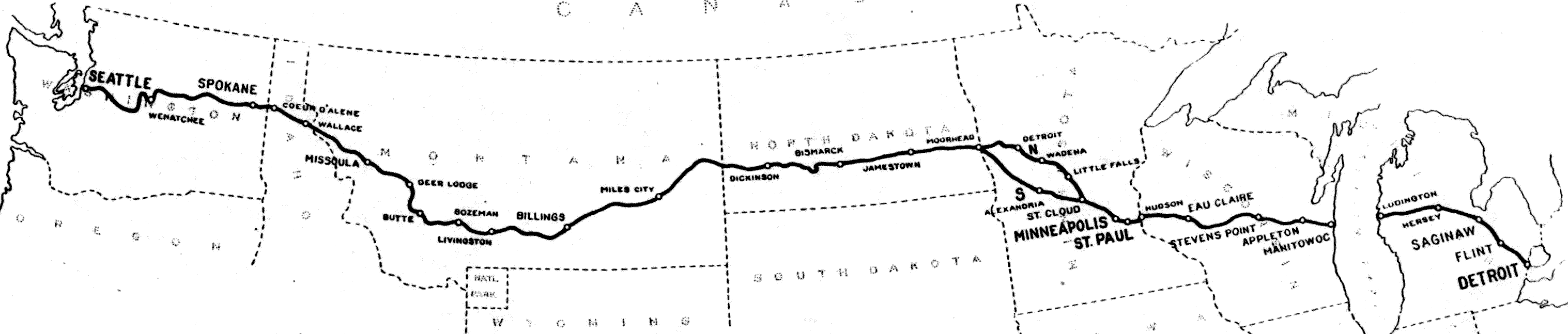
c. 1927, US Government Printing Office
|
This map above, showing the original extent of US 10, was included in a 1927 US Dept. of Agriculture Office of Information press release, issued shortly after the US routes were commissioned.
Now that most of its original route has been functionally replaced by newer interstates, US 10 has been reduced to a mere shadow of its former self: it exists only between Bay City and Fargo. But for the first 60 years of its existence, the east end of US 10 was in Detroit...
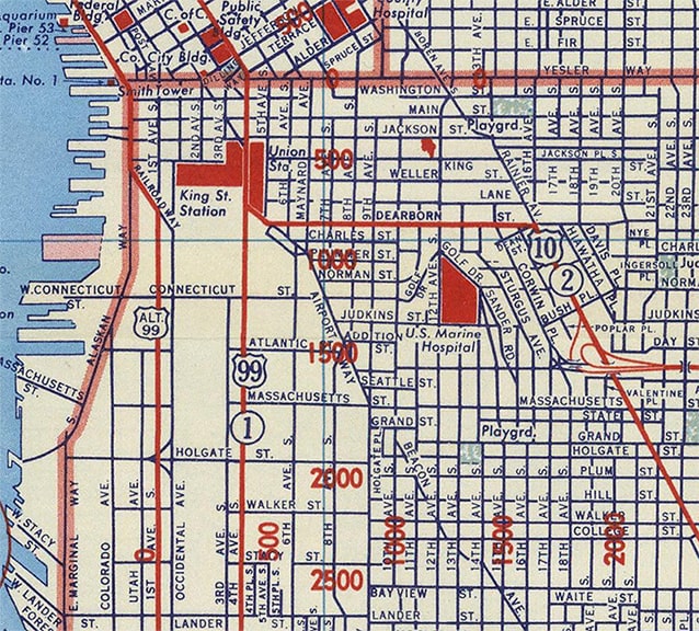
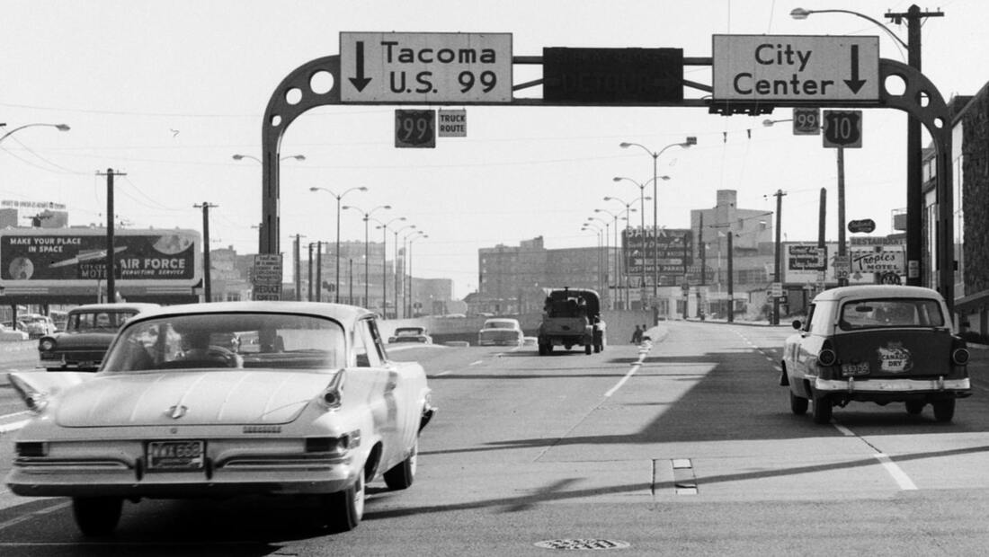
...and for over 40 years, the west end of US 10 was in Seattle. Originally traffic was directed into town on Rainier Avenue, then turned west on Jackson Street. US 10 ended at 4th Avenue, where it junctioned US 99: |
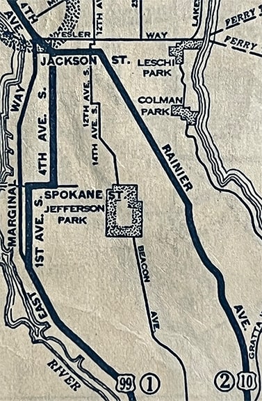
c. 1934, Gallup
|
|
This next photo was taken in the same year that map was made. It was looking west on Jackson at 4th, so it shows what the west terminus of US 10 looked like at the time. If you view the original and zoom in, you can make out a US 10 shield at left and a US 99 shield on the far right:
|

c. 1934 (linked to source)
|
|
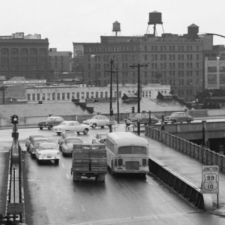
That remained the case until about 1937. At that time, US 10 traffic was routed off Rainer via Dearborn Street (instead of Jackson, which is four blocks further north). Just before reaching 4th, drivers angled slightly northwest on the former Airport Way (now renamed to Seattle Boulevard), and then US 10 ended at 4th:
|
c. 1956, Gousha
|
|
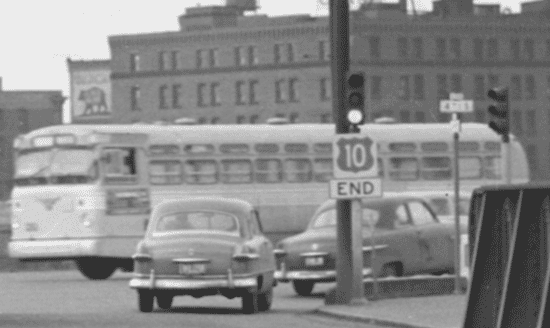
These next photos were taken about one year before that map was made, showing the perspective of Seattle Blvd. at 4th. This first one shows a unique sign at lower right, posted about a half-block before the intersection and proclaiming "Junction US 99, End US 10":
|
c. 1955 (linked to source)
|
|
At the intersection itself, a "US 10 END" assembly is visible; the next image shows that in more detail, and I have also colorized it to approximate how it looked at the time (more details about Washington's temporary use of colored US route shields can be found on this page):
|
c. 1955 (linked to source)
|
|
Here is a much more recent photo taken from the same perspective...
|

Elbert, Feb. 2005
|
|
...although this area has been rebuilt and looks quite a bit different now than it did when US 10 ended there. Next is a shot from southbound 4th, or historic southbound US 99:
|
Elbert, Feb. 2005
|
For about 23 years US 10 began to the left. But in about 1960, when US 99 was rerouted along the Alaskan Way Viaduct and tunnel, US 10 was extended along the former route of US 99 through downtown (which was also signed as Business 99). This 1961 photo, looking south on Aurora Avenue, shows the west beginning of US 10 at that time:
c. 1961 (linked to source)
|
Note the unique sign bridge; that would remain in use for another six decades, but it was removed in 2019. It is visible in this next photo, which was looking the same direction (south on Aurora):
|

Elbert, Feb. 2005
|
|
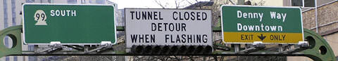
That is now southbound WA hwy. 99, but it was formerly US 99. Traffic was directed to go straight ahead into the tunnel, but at one time US 10 traffic was directed to take the Denny Way/Downtown exit. The final version of that sign bridge is shown close-up here:
|
Elbert, Feb. 2005
|
|
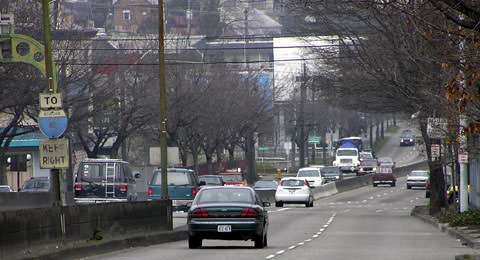
This next photo was looking north on Aurora, where traffic coming from Battery Street, 7th Avenue, and Denny Way (on the right) merged with traffic coming out of the tunnel (on the left), so this view would have been the perspective at the west end of US 10:
|
Elbert, Feb. 2005
|
1969 saw the first in a series of transitional truncations of US 10 that took place as segments of its replacement (I-90) were completed. Below is the agenda item from AASHO's actual meeting minutes:
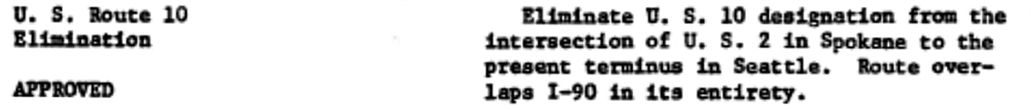
Within five years the length of US 10 had been reduced by nearly 500 miles, and it no longer existed in Washington or Idaho. Then in 1986 the US 10 designation was removed from all of Montana, and most of North Dakota, shortening its length by another 900 miles:
|
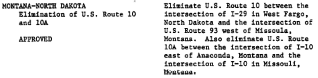
Today the west end of US 10 is west of Fargo, at its interchange with I-94. This photo shows the last westbound US 10 marker:
|
Wilson
|
|
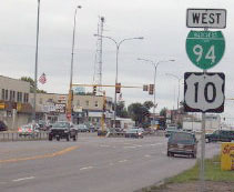
That was looking west on Main Avenue in West Fargo (that assembly had been replaced by 2007). Continuing that direction, one reaches the west end of the route, shown here:
|

Nitzman, Apr. 2007
|
That shows the signage at the west end of US 10/Business I-94. The original route continued west from here, roughly along today's I-94, to Billings MT. From there, US 10 basically followed modern I-90 all the way to Seattle. One can still drive on much of the original route.
|
This next set of photos was taken from eastbound I-94:
|
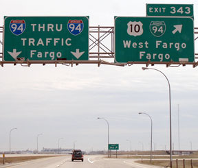
Nitzman, Apr. 2007
A recent replacement of those signs added a US 52 marker, but unfortunately Bus. 94 was mis-labeled as mainline I-94:
|

Ochs, Jul. 2024
|
|
That 2024 photo shows that a recent replacement of those signs added a US 52 marker, but unfortunately Bus. 94 was mis-labeled as mainline I-94. Today US 10 begins by exiting to the right, then passing over I-94, and then resuming on the alignment straight ahead. At that point, the first eastbound US 10 marker is posted:
|
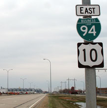
Nitzman, Apr. 2007
|

Ochs, Jul. 2024
|
|
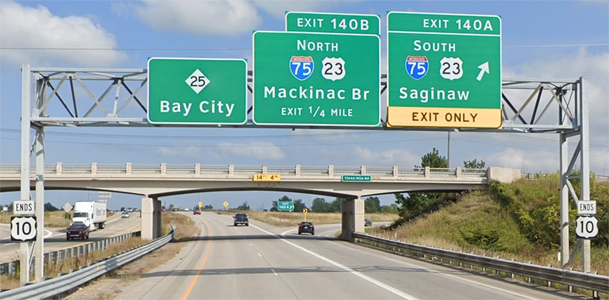
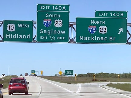
One year before being truncated at West Fargo, the east end of US 10 was shortened as well, because the segment between Detroit and Bay City was eliminated. These photos were taken in Bay City, from southbound I-75:
|

Ivy/Nitzman, 2009
|
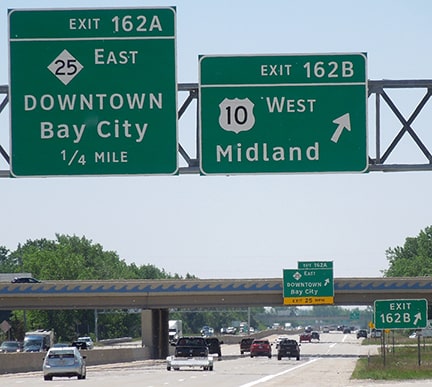
Sanderson, Jun. 2022
|
|
The east beginning of US 10 is to the right. Drivers exiting that direction almost immediately encounter the first westbound confirming marker:
|
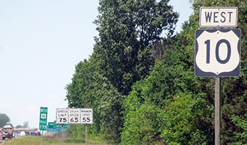
Sanderson, Jun. 2022
|
|
Heading the opposite direction, the final eastbound trailblazer is posted after the on-ramp from Mackinaw Road:
|
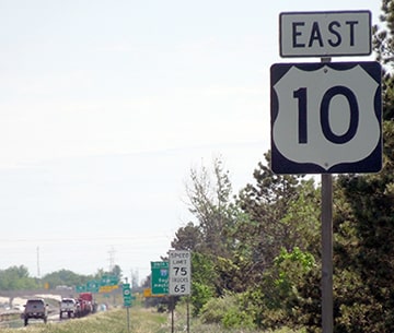
Sanderson, Jun. 2022
|
|
The signs barely visible in the distance are shown close-up here; this next shot was taken from eastbound US 10 at the I-75 interchange (the overpass is Three Mile Rd):
|
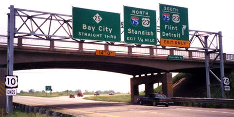
Sanderson, May 1999
|
|
All of those signs were later replaced, including (perhaps most strangely) the "US 10 Ends" assemblies, which were changed to "Ends US 10"...
|

Allen, Dec. 2009
|
|
...and that entire sign bridge was dismantled in 2016 and moved farther away from the Three Mile overpass. It is not easy to get a decent photo of these signs, and sometimes we are lucky to be able to rely on Google Street View:
|
Google Maps Street View, Sep. 2019
|
The highway itself does continue straight ahead into Bay City, but east of the I-75 interchange it is designated M-25. It is interesting that US 10 ends here now, considering that Bay City was not even on the original alignment of US 10. Instead, from Midland, it followed today's M-47 and M-58 into downtown Saginaw. From there, it roughly followed I-75 through Flint and Pontiac, where it was then routed along Woodward Avenue right into the heart of downtown Detroit. It ended there on the waterfront, along with US 16, US 12, and US 112, at its junction with US 25. Today, US 12 is the only one of those highways still serving downtown (more info on the Detroit page).
|
These photos were from the opposite direction: eastbound on M-25 at the beginning of US 10:

Hatchard, Jan. 2003
|
Sanderson, Jun. 2022
|
|
Heading that direction, today's US 10 is routed onto a newer limited-access freeway between Bay City and Clare. However, most (if not all) of the original route is still driveable from Detroit to Clare. West of Clare, US 10 has not changed much. Upon arriving in Ludington, one must use a car ferry in order to get across Lake Michigan to Manitowoc WI, where US 10 continues westward. The signage in Ludington belies that fact, though:
|
Reynolds, May 2002
|
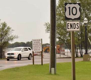
Voss, Sep. 2018
|
|
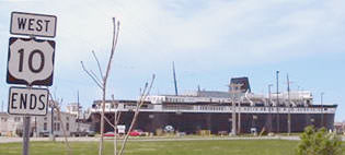
But, heading the other direction on US 10 in Wisconsin, signage in Manitowoc leaves no question that US 10 continues via the ferry:
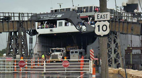
Voss, Sep. 2018
|
In the background is visible one of the car ferries that AASHTO considers an official component of the US 10 facility. It actually has an image of a US 10 shield on it:

Kasprzyk, Sep. 2012
|
Research and/or photo credits: Patrick Allen; Chris Elbert; Geoff Hatchard; Brent Ivy; Bruce Kasprzyk; Alex Nitzman; Jeff Ochs, Brian Reynolds; Mike Roberson; Dale Sanderson; Michael Summa; Oscar Voss; Ed Wilson
Page originally created 1999;
last updated Jul. 8, 2024.
last updated Jul. 8, 2024.
