End of US highway 85 |
 |
Summa
|
Summa
|
|
1926-1940
|
1940-1946
|
1946-present
|
|
Mileage: in 1989 AASHTO listed a figure of 1479 miles for US 85. That closely matches our own 2020 measurement, which yielded 1477.0 miles.
|
|
|
US 85 was an original 1926 route. At the time its south end was in Las Cruces (from there, it was US 80 that carried traffic into El Paso):
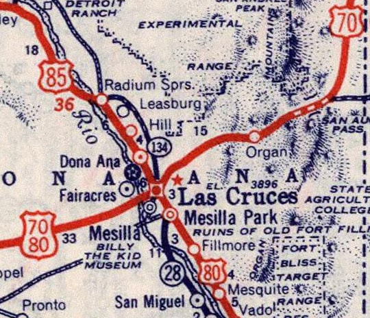
c. 1939, Rand McNally
|
The photo below is looking west on Picacho Avenue:
Sanderson, Mar. 2016
|
|
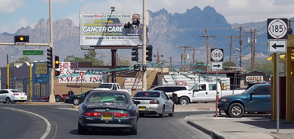
That is westbound US 70, but historically Picacho also carried US 80, and to the right on Valley Drive was the south beginning of US 85.
Here is a perspective from the opposite direction (east on Picacho), with the Organ Mountains prominent in the background: |
Sanderson, Mar. 2016
|
That was once eastbound US 70-80, which continued ahead a few blocks to Main Street, where those routes diverged. To the left on Valley was the original south beginning of US 85. In 1946 the US 85 designation was extended southward; more info on the El Paso page.
|
Far off in North Dakota, approaching the north end of US 85 -- instead of veering west and then north at Fortuna to Canada (as it does now) -- US 85 was originally routed east and then north through Ambrose to that port of entry:
|
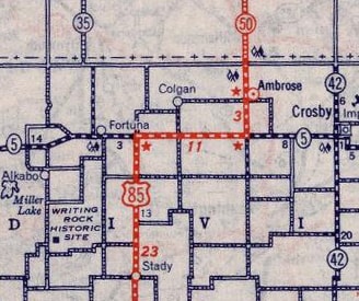
c. 1939, Rand McNally
|
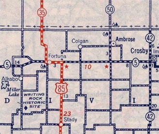
c. 1940, Rand McNally
|
|
This 1932 photo was taken when US 85 was still routed through Ambrose. The customs house was probably brand-new at the time; this was looking northbound at the end of US 85:
|
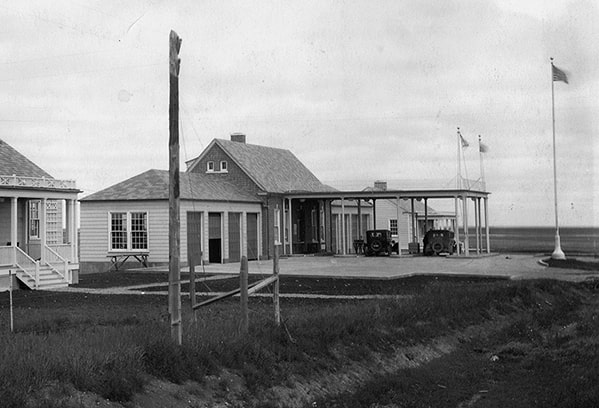
c. 1932, National Archives
|
|
That is an example of a Colonial Revival style customs house, which was commonly used at border stations in the northern and northeastern parts of the country (compare to the abandoned customs house on US 2 in Houlton ME). The one at Ambrose is still in use; here is a detail shot:
|
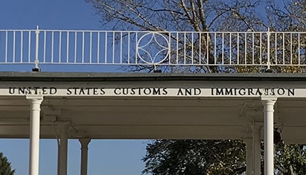
Sanderson, Oct. 2021
|
|
Just ahead was the international border, and the Canadian port of Torquay on the east side of the road:
|
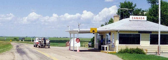
wbaron, c. 1998
|

|
In 1940 the north end of US 85 was shifted to its present terminus. This photo was looking north from the town of Fortuna, and it shows the last northbound US 85 marker:
|
Sanderson, Oct. 2021
|
|
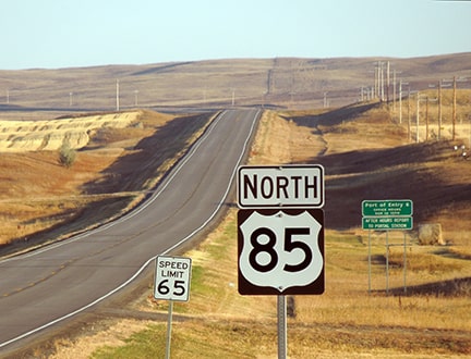
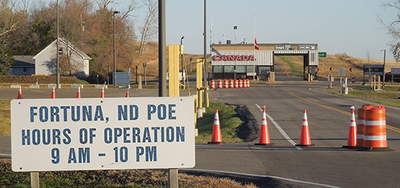
About six miles ahead from there is the Fortuna border station, at the Oungre port of entry into Canada. Although there was no "End" sign, these photos show the north end of US 85:
|

Taylor, 2000
|
|
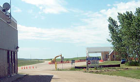
In that photo, the customs station at far left is no longer standing; it has since been replaced with the one visible in this next photo:
|
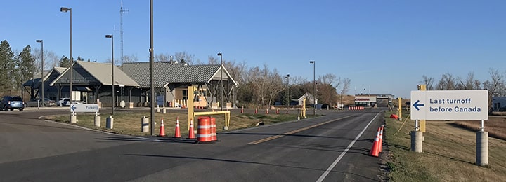
Sanderson, Oct. 2021
|
|
Visible in the distance is the Canadian checkpoint; it is shown more closely in this photo:
|
Sanderson, Oct. 2021
|
|
If one were to continue across the border, they would be on Saskatchewan provincial highway 35. Heading south on that highway, this was a view approaching the customs station:
|

Macdonald, 2003
|
|
In this photo, we are right next to the building in the middle of the right-of-way; the north beginning of US 85 is just ahead, curving in the distance:
|
Macdonald, 2003
|
|
Near the excavator visible in that photo, the first US 85 trailblazer is posted (the backside of this sign is visible in one of the previous photos, above):
Taylor, 2000
|
Sanderson, Oct. 2021
|
|
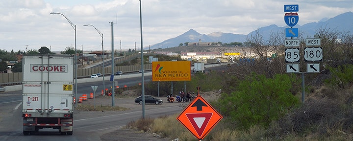
Although US 85 runs all the way between the Canada and Mexico borders, its integrity has been compromised in New Mexico and Colorado. After I-25 and I-10 were built, US 85 was rerouted onto interstates all the way through NM. So apparently in 1990 the state decided it was a superfluous route, and nearly all signs have been removed. Traveling north from El Paso, the last US 85 sign drivers will see for about 560 miles is at the Texas/New Mexico border:
|
Sanderson, Mar. 2016
|
A handful of US 85 signs still remain in NM, but they are all relics that refer to the historic (pre-interstate) route. Along the implied (interstate) route, there is no mention of US 85 from Texas to halfway through Colorado. Unlike New Mexico, Colorado has not completely eliminated US 85; however CDoT generally does not dual-sign US 85 where it runs concurrently with interstates. Instead, US 85 is considered to have three separate segments in the state. The southernmost segment begins at I-25's interchange 128 at Fountain... and it never rejoins I-25. Shortly after passing over I-25 (with no access to the freeway), this orphaned segment of US 85 just quietly ends at a nondescript intersection, while the road itself continues ahead as a city arterial. CDoT is severely misguided in continuing to sign a road like that with a US highway shield.
Colorado's middle segment of US 85 runs between I-25's exit 184 in Castle Rock and exit 208 in Denver (most of this stretch is referred to locally as Santa Fe Drive). This is a legitimate highway, but north of there is an implied (almost entirely unsigned) overlap with I-25 and I-70 through central Denver. Colorado's northernmost segment of US 85 begins at exit 276 on I-70, where it is finally allowed to start behaving in a manner consistent with what one expects from a US highway. US 85 runs up into Wyoming, where it gets the respect it deserves.
Colorado's middle segment of US 85 runs between I-25's exit 184 in Castle Rock and exit 208 in Denver (most of this stretch is referred to locally as Santa Fe Drive). This is a legitimate highway, but north of there is an implied (almost entirely unsigned) overlap with I-25 and I-70 through central Denver. Colorado's northernmost segment of US 85 begins at exit 276 on I-70, where it is finally allowed to start behaving in a manner consistent with what one expects from a US highway. US 85 runs up into Wyoming, where it gets the respect it deserves.
Research and/or photo credits: Chris Elbert; Alan Hamilton; Julian Macdonald; Dale Sanderson; Michael Summa; Stephen Taylor; wbaron
Page originally created 2000;
last updated Oct. 26, 2021.
last updated Oct. 26, 2021.
