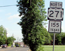
End of US highway 271 |
 |
|
1926-1930
|
1930-1934
|
1934-present
|

Summa
|
Mileage: in 1989 AASHTO listed a figure of 303 miles for US 271... however, that included the mileage of US 271's associated business route. According to the state subtotals on AASHTO's 1989 spreadsheet, mainline US 271's actual end-to-end total at the time was 299 miles. That closely matches our own 2020 measurement, which yielded 296.2 miles. Historically, when it went to Beaumont, US 271 was 491.1 miles long.
|
|
The preceding excerpt is from AASHO's Apr. 1927 route log. Although both of the original endpoints for US 271 were in Arkansas, most of the route (as defined in 1926) would have run through Oklahoma. So the intention for US 271 was an alternate route for US 71 (which ran entirely on the Arkansas side of the line). However, it is debatable whether US 271 was signed from either of its Arkansas termini until after 1930, which is when its south end was rerouted to Texas (more info on the Mena page). It was probably only then that Arkansas was willing to sign the short segment that ran through their state, including the northern terminus, which has always been in Ft. Smith.
|
|
On Arkansas official state highway maps from the 1930s, none of the Ft. Smith insets even include a label for US 271. This commercial map is the earliest one I have seen that shows US 271:
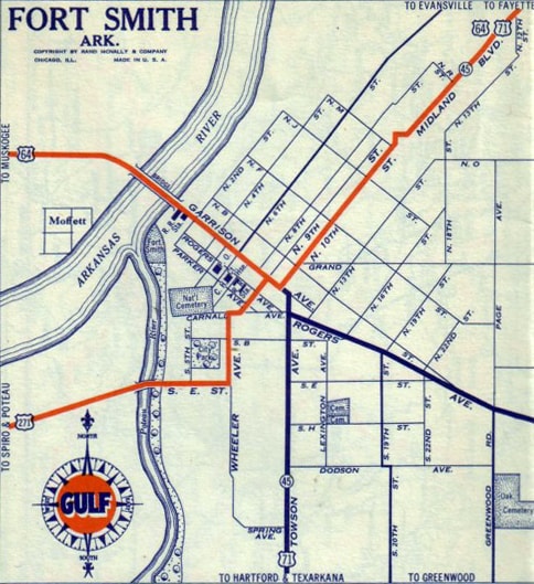
c. 1932, Rand McNally
|
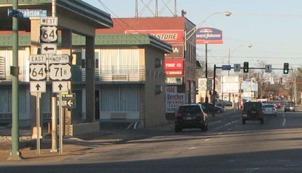
According to that, the terminus of US 271 was probably where it connected with its "parent" route (US 71), on Garrison Avenue at 10th Street. US 71 came in on Towson Avenue (just behind the camera in this interactive image), then turned the direction shown here, which is looking northwest on Garrison. US 71 continued by turning to the right on 10th, with eastbound US 64. Straight ahead on Garrison was not only westbound US 64, but probably also the beginning of US 271:
Note that just behind that view was a later terminus of US 271 (discussed below). But prior to that, US 271 split off from US 64 one block ahead by turning left on 9th St. It then made a couple more turns before winding up on South "E" Street, which at the time was aligned with a bridge over the Poteau River and into Oklahoma.
|
|
That bridge was situated in the bottomlands between the Poteau and Arkansas rivers, and was therefore subject to frequent flooding. In fact, this photo was taken during a flood:
|
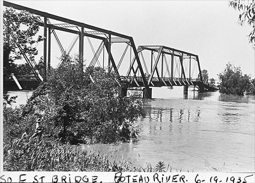
attribution unknown (linked to source)
|
Today almost nothing of that bridge remains, and there is no trace of the old road on the Oklahoma side, which has probably been scoured by multiple floods over the years.
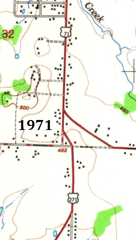
Already by 1936, US 271 had been directed to use a different route: traffic followed what is now OK hwy. 9A (which crosses the Poteau about two miles upstream from "E" Street) and becomes Arkoma's Main Street before connecting with South "Y" Street in Ft. Smith. |
|
After another ten years or so, another bridge was built over the Poteau, at the location of US 271's modern crossing (which is about eight miles upstream from "E" Street). Both bridges connected US 271 traffic with US 71 at Towson. The two routes were twinned to the north, with US 271 continuing to terminate essentially at its original endpoint (Garrison, which carried US 64):
c. 1951, USGS
|
c. 1956, Gousha
|
|
This photo was taken looking east on Garrison, or eastbound US 64, which continues by turning left on 11th Street. Northbound Business 71 also goes that way, while southbound is to the right on Towson:
|

Backlin, Feb. 2008
|
Backlin, Feb. 2008
|
|
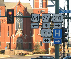
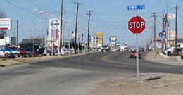
The US 271 sign is no longer accurate, but it is fitting, because to the right on Towson was formerly the north beginning of that route (now one must go about four miles that direction to reach the actual beginning of US 271). The backside of that assembly is visible at far left in this photo:
|
Backlin, Feb. 2008
|
|
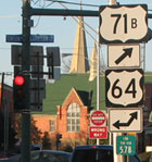
That was looking north on Towson. Just before reaching Garrison, traffic makes a gentle angle onto 11th; the signage at that intersection is shown here:
|
Backlin, Feb. 2008
|
|
That is essentially the original north end of US 271, at its junction with US 64... although historically Towson did not curve to align with 11th, but rather continued straight north, intersecting Garrison between 10th and 11th (as illustrated on the maps above).
It was probably in the 1960s that US 271 was truncated to its current endpoint. In the area of its junction with Business 71 (formerly mainline US 71), the road alignments have changed. Initially, after crossing to the north of Zero Street, US 271 was routed slightly northwest, along what is now Towson Place, then Towson Avenue, ending at its junction with US 71. But in about 1982 the configuration was changed, such that US 271 angled northeast, meeting Business 71 at a more perpendicular angle: |
USGS, 1:24k series
|
|
This photo was looking north on Towson at a former endpoint of US 271. Straight ahead is north on Towson and Business 71; southbound Bus. 71 angles off to the lower right:
|
Backlin, Feb. 2008
|
|
This photo was looking the opposite direction (south on Towson). US 271 formerly began straight ahead on Towson:
|

Backlin, Feb. 2008
|
|
...but now US 271 begins about a block to the left. Continuing that way, the assembly shown here was posted:
|
Backlin, Feb. 2008
|
|
That was looking southeast on southbound Business 71; US 271 begins to the right. This shot was looking north on US 271 where it ends:
|
Backlin, Feb. 2008
|
Business 71 is on a diagonal road at that point -- a connector between Towson and Zero Street. Street signs refer to this segment simply as "Highway 71".
|
By 1930 US 271 had been rerouted to go through Hugo OK, and by 1932 it had been extended further south, all the way to Beaumont, via today's US 69:
|
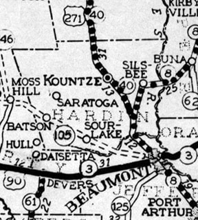
c. 1935, TX DoT
|
|
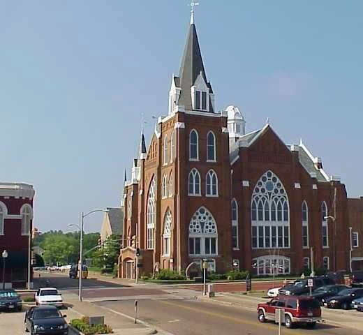
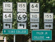
There, it appears US 271 came in on Concord Road, then made a few jogs in town, winding its way over to southeastbound Railroad Avenue, ending at College Street, which carried US 90. This photo was taken from that intersection, looking east on College, but things have changed so much there that the scene today hardly resembles what it looked like back in the 1930s:
|

Karners, Jan. 2015
|
|
College is now one-way eastbound, but historically it carried both directions of US 90. Its grade at this particular intersection has since been lowered; it was sunk in order to go under a railroad viaduct. To the left via northbound Spur 380 was once the south beginning of US 271. That street was formerly called "Railroad", but now it is known as M.L. King Parkway. Railroad carried both directions of US 271, but now southbound MLK runs along a segment that is just behind the camera.
In 1934, US 69 was extended through Beaumont, so the south end of US 271 was truncated at Tyler. At first the route turned off Gentry Parkway onto Valentine Street, then Broadway Avenue, then Bow Street to Bois d'Arc Avenue, where it junctioned US 69. So US 271 could have ended there, but it is more likely that the two overlapped south on Bois d'Arc, with US 271 ending at Erwin Street (which carried TX 31 and TX 64): |
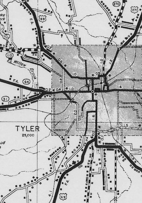
c. 1936, TX DoT
|
|
This image was looking south on Bois d'Arc. This was US 69-271, but US 271 ended here at Erwin. US 69 continued ahead on Bois d'Arc, then east on Front Street, then south on Broadway:
|
(date and attribution unknown)
|
|
That was the case until 1944, which is when (according to TXDoT's highway designation file for Spur 147) US 69 traffic was rerouted to bypass downtown via Glenwood Boulevard and the 4th/5th Street couplet. But by then, Beckham Avenue's 1937 viaduct over the railyards had been built (presumably to divert eastside traffic away from downtown as well). So for a few years, US 271 probably went south on Beckham to Erwin, then west to the same terminus. But after US 69 was changed, the 1949 USGS topo suggests that US 271 was extended down Beckham, west on Front, and south on Broadway, ending at 4th/5th:
|
Google Maps Street View, Mar. 2013
|
|
This photo was looking the opposite direction (north) on Broadway, or US 69, which continues to the left on 4th/5th. Straight ahead on Broadway was once the south beginning of US 271:
|
Nelson, Aug. 2007
|
|
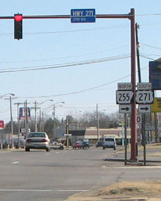
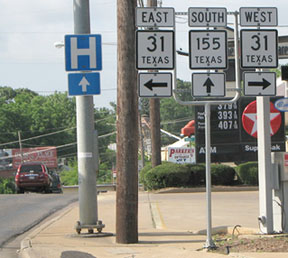
That lasted until sometime during the 1950s, when US 271 was truncated to its current terminus. This photo was looking south on Beckham (US 271/TX hwy. 155) at Front (TX 31):
|
Backlin, May 2008 (unchanged as of 2019)
|
|
TX 155 continues straight ahead, but not US 271. It is not very common for a US route to terminate at a state route, but for much of US 271's history, its Tyler endpoint has been an exception. Except for the lack of an "End" assembly, this junction is impeccably signed. These next shots were taken from Front (eastbound and westbound, respectively); the south beginning of US 271 is to the north on Beckham:
|
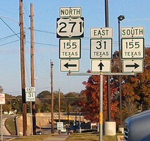
Brooks, Nov. 2012
|

Backlin, May 2008 (unchanged as of 2019)
|
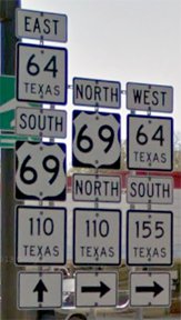
|
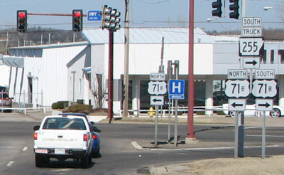
This next photo was looking north on Beckham, and if one continues ahead past Front, the first northbound confirming assembly is posted:
|
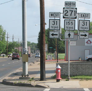
Backlin, May 2008
|
Backlin, May 2008
|
Fort Smith AR is about 300 miles ahead. Although staying on US 271 for the entire distance is not the fastest route to get there, it certainly is a scenic way to get there.
Research and/or photo credits: James Allen; David Backlin; Robert Brooks; Justin Cozart; Nathan Edgars; Karin and Martin Karner; Jeremy Lance; Gene McCluney; JP Nasiatka; Steven Nelson; Dale Sanderson; Michael Summa
Page originally created 2001;
last updated Dec. 3, 2023.
last updated Dec. 3, 2023.
