US highway endpoints in Astoria, OR1927-present
|
 |
|
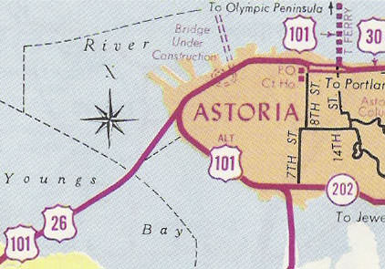
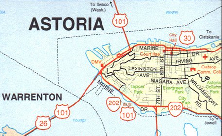
Astoria is well-known among road enthusiasts, because it marks the west end of US 30: the only remaining US highway that has always been coast-to-coast (from the time US routes were commissioned in 1926 to the present day). And then, in 1952, the west end of US 30 became the west beginning of US 26, and vice-versa. An intriguing place. But things have changed a lot over the years: for one thing, the impressive Astoria-Megler Bridge over the Columbia River was not built until 1966. So for 40 years the west endpoint of US 30 was at a different location than its current terminus:
|
c. 1966, ODoT
|
|
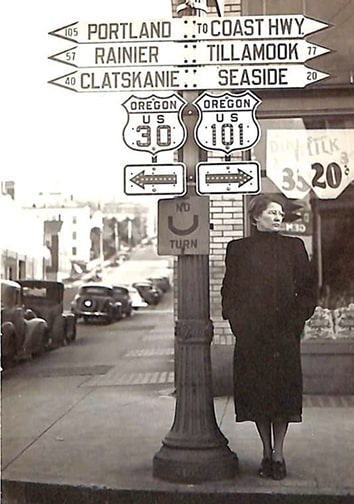
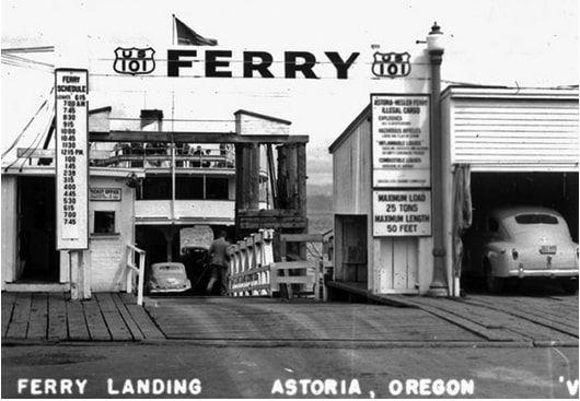
At the time of that map, today's bridge was under construction, and also shown is the ferry line that carried traffic across the river to Washington before the bridge's completion. So originally the west end of US 30 was at its junction with US 101 near the 14th Street Ferry Terminal. This photo was taken about a block south of there, looking south on 14th (the 1923 building shown here still stands). Southbound US 101 traffic coming off the ferry was directed to continue to the right on Commercial Street, while to the left was the west beginning of US 30:
|
c. 1938 (attribution unknown)
|
|
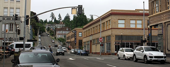
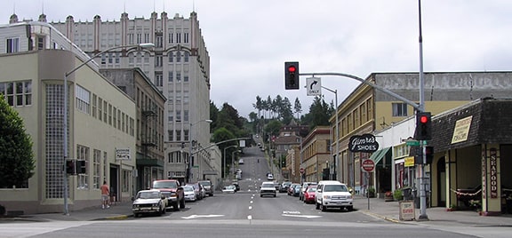
Following is a modern photo looking the same direction (the building and lamppost shown in the historic photo above are on the right side of the street). This was southbound US 101, which turned right on Commercial; to the left was the west beginning of US 30:
|
Elbert, Jul. 2022
|
|
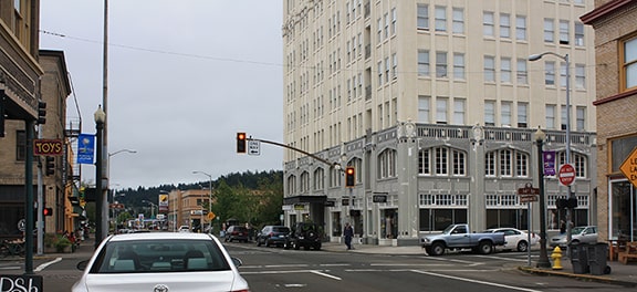
Here, we are looking east on Commercial. Historically this was northbound US 101, which continued by turning left on 14th to the ferry. Straight ahead was the west beginning of US 30:
|
Elbert, Jul. 2022
|
|
And finally, the opposite direction: this would have been the west end of US 30. Straight ahead on Commercial was southbound US 101, and northbound was to the right on 14th:
|
Elbert, Jul. 2022
|
The 1966 map shown above appears to be the earliest Astoria inset included on Oregon official highway maps. Clearly by then traffic had been split into the one-way couplet of Commercial and Marine Drive. When that was implemented, then southbound US 101 would not have been directed to the right on Commercial (as shown on the 1938 photo above), but instead to the right on Marine. So when did that happen? The 1951 map below shows highway traffic leaving Commercial via 14th and then resuming west via Marine:
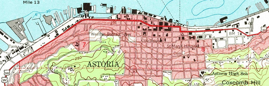
c. 1951, USGS
If that map was correct (I have some doubt, as I'll explain below), then the terminus of US 30 moved one block north (to 14th at Marine).
|
These next two photos were taken from the same perspective, looking north on 14th:
Elbert, Nov. 2004
|
Westbound US 30 ended there. Southbound US 101 was to the left on Marine, while northbound was straight ahead (onto the ferry), as shown in this 1947 photo:
c. 1947 (attribution unknown)
|
|
The US 26 designation was extended to Astoria in 1951 (as illustrated on both maps above). So then to left on Marine was not only southbound US 101, but also eastbound US 26 (which started out by heading, yes, further west). One wooden structure visible in the 1947 photo above was still there decades later; here is a close-up view:
|
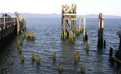
Elbert, Nov. 2004
|
|
That is all that remains of the old ferry landing (the land visible in the distance is in Washington; the river is about four miles wide at this point). In this next photo we are looking the opposite direction (south on 14th):
|
Elbert, Nov. 2004
|
That is the view a traveler would have had as they drove off the ferry: eastbound US 30 was straight ahead one block and then to the left on Commercial. Until at least 1938, southbound US 101 was straight ahead and then right on Commercial. If the 1951 map can be believed, then at some point traffic was moved off Commercial and onto Marine instead. At that time southbound US 101 would have continued to the right on Marine, and also to the right (after 1951) was the west beginning of US 26. But here is why I question the accuracy of the 1951 USGS map:
- We know from the 1966 ODoT map that east-west traffic had been split into the one-way pair of Commercial and Marine.
- However, the downtown area on the 1973 USGS topo map looks identical to the 1951 map above (in terms of showing all highway traffic moved off of Commercial).
- So clearly the 1973 USGS map was erroneous in not depicting the one-way couplet.
- The question is, was the 1951 map also inaccurate (i.e. did the couplet already exist by then)?
- Or was the 1951 map accurate, and the couplet was established sometime after 1951 and before 1966?
|
This early 1960s photo, looking west from about 16th Street, showed the west end of US 30 at that time. The building at far left is at the corner of 15th and Commercial, and the taller brown building (which is now white) still stands at 14th and Commercial:
|
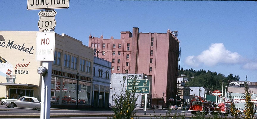
c. 1960s (attribution unknown)
|
|
That is right about where Commercial and Marine diverge. Straight ahead on Marine was southbound US 101, while northbound 101 traffic was directed right on 15th towards the "toll ferry loading zone":
|
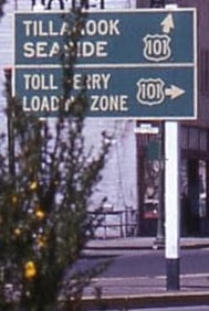
(detail)
|
|
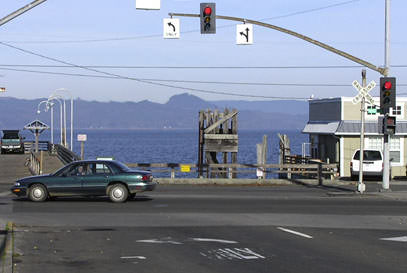
After the bridge was built in 1966, the ferry ceased operations later that same year. The western endpoints of US 26 and US 30 were then changed to the bridge landing, about a mile to the west. US 26 continued to serve Astoria until that designation was truncated in 2003; the 2000 state highway map was one of the last to show the old arrangement:
|
c. 2000, ODoT
|
|
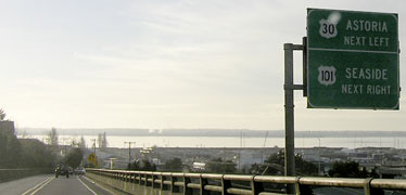
In these photos the perspective was heading south on US 101 from Washington, via the bridge. Today traffic crosses the Columbia River via the impressive Astoria-Megler Bridge. The approach signage near the landing on the Oregon side formerly included a reference to US 26...
|
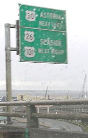
Elbert, Mar. 2004
|
...but that was removed later in 2004:
Elbert, Nov. 2004
|
In those shots one can see past the Astoria peninsula and across Youngs Bay. Ahead the road curves to the right and traffic essentially makes a 360-degree circle to descend to surface level at Marine Drive. At the stoplight there, signage welcoming travelers to Oregon and Astoria included a reference to the west beginning of US 30 and the west beginning of US 26...

Morrison, Aug. 2001
|
Elbert, Mar. 2004
|
...but by June 2004, the US 26 marker had been covered up:
Elbert, Nov. 2004
|
During Dave's 1999 visit, he noted that "US 30 ends with a complete lack of fanfare in Astoria. There are no special distance signs, and no 'end' marker." Fortunately that changed a bit after the signage replacements that took place in 2004:

Elbert, Nov. 2004
|
Elbert, June 2013
|
|
That was approaching the bridge westbound on Marine. That "End US 30" assembly was undoubtedly new in 2004; before that, there was most likely a "East US 26" marker in its place. Chris reports that US 30 shield was later damaged, but all panels had been replaced by 2013.
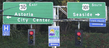
The green overhead signs in the distance are shown close-up here. (There was a mistake on the left sign: that junction is actually with Business 101, not Alternate 101. That is the original route of US 101, before the new Youngs Bay Bridge was built. Although "Alternate" would probably be a better choice than "Business", since the route does not pass through Astoria's central business district.) |
Elbert, Nov. 2004 (unchanged as of 2022)
|
|
That photo shows the intersection that marks the actual west end of US 30. Beyond that point was once the west beginning of US 26, but that is no longer the case. Barely visible in the distance is a confirming marker; here is a closeup:
|
Elbert, Mar. 2004
|
|
That is where US 101 passes under itself; it is possible that post formerly supported a US 26 marker as well. (That assembly now includes mileage to various Lewis & Clark historic sites.) In another block or so, there was once another ghost of US 26:
|
Elbert, Mar. 2004
|
|
In the upper right, the old US 26 shield had been covered up (that sign had been replaced by April 2006).
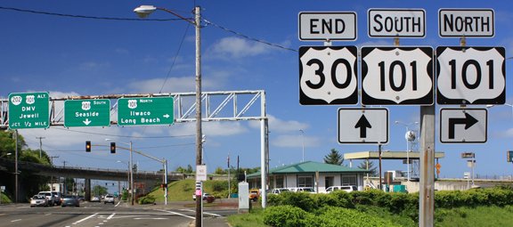
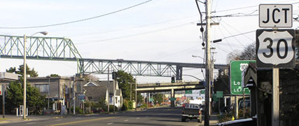
Next, here is the approach from the opposite direction (east on Marine, or northbound US 101): |
Elbert, Nov. 2004
|
|
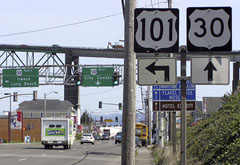
That shot provides a good overview for what US 101 does: past the first overpass (concrete), traffic is directed to turn left. The road curves left again (back towards the camera) and then left again (viewer's right) to cross the concrete overpass. Then it curves left again (away from the camera), and finally one more lefthand curve puts traffic on the Megler Bridge (the second overpass). Approaching the first left turn is the signage shown here:
|
Elbert, Apr. 2006
|
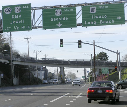
If OR DoT typically used "End" markers, this is probably where an "End US 26" sign would have been posted. But historically they have not, and the two exceptions are recent: the "End US 30" assembly shown above, and an "End US 26" sign at its new terminus. The green signs ahead are shown close-up here:
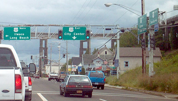
Long, June 2004
Nasiatka, Feb. 2022
|
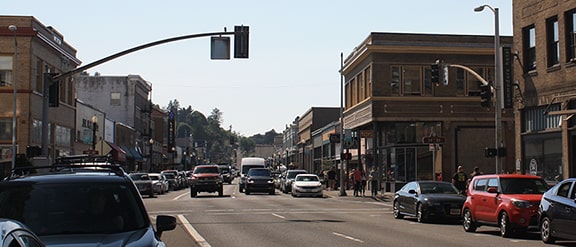
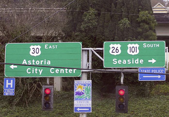
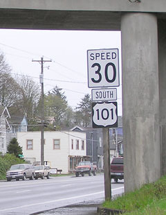
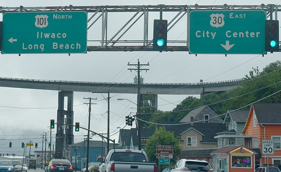
That is the west beginning of US 30 (the sign tower at far right is shown face-on in photos above). Ahead, eastbound traffic is routed onto one-way Commercial Street for a few blocks, and Chris reports there are a couple US 30 markers with directional arrows to help traffic navigate. Next is a photo of the first confirming marker:
|
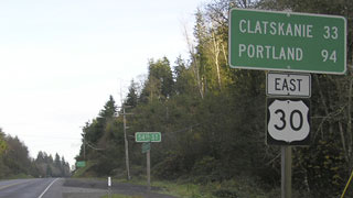
Elbert, Nov. 2004
|
That was posted about about four miles east of the Astoria-Megler Bridge.
Research and/or photo credits: Chris Elbert; Mark Long; Jeff Morrison; J.P. Nasiatka; Dale Sanderson; Dave Strong; Mike Wiley
Page originally created 2004;
last updated Apr. 8, 2023.
last updated Apr. 8, 2023.
