Current and historic US highway endpoints in Cleveland, OH |
 |
|
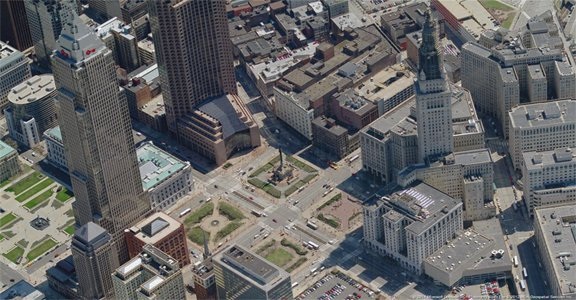
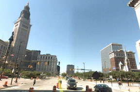
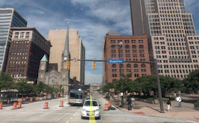
Cleveland's "ground zero" is the intersection of Superior Avenue and Ontario Street... or technically "was" that intersection, as those two roads no longer actually intersect. The blocks comprising all four corners of this former intersection (lower center of the following aerial photo) are referred to collectively as "Public Square":
|
c. 2012
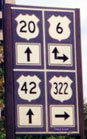
|
c. 1932, ODoT
|
For the first 45 years of the US highway system, four routes shared a terminus on Public Square. US 21 was decommissioned in Ohio in 1971, but the remaining three routes still end there. The intersection of Superior/Ontario was the original endpoint for all routes, and probably always the intended endpoint, and it is still the actual endpoint for US 422. However, according to Ohio DoT's Straight-Line-Diagrams (SLDs), the official endpoint for both US 42 and US 322 is now one block to the east (more on that below). Beginning in 2015, Public Square underwent a redesign, and when the project was completed in 2016, the four separate "patches" of Public Square shown in the photo above were more physically unified. Now Ontario is completely vacated through the Square.
|
|
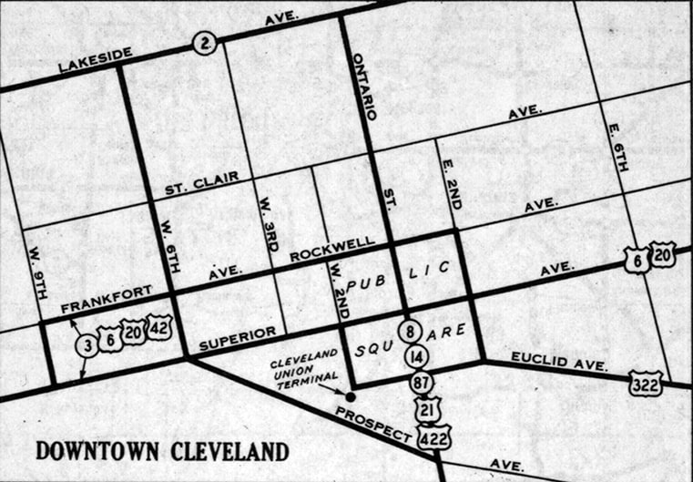
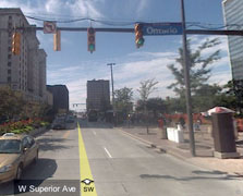
The north edge of Public Square is formed by Rockwell Avenue, while "South Roadway" runs along the south side (in other words, these are the sides of Public Square that are parallel to Superior). The west side is called "West Roadway", and the east side of Public Square is bounded by "East Roadway" (these are parallel to Ontario). At some point, left turns were banned at the intersection of Superior and Ontario. Presumably accompanying this change, these roads running along the outer perimeter of Public Square were converted to one-ways, such that they now essentially function as a giant counter-clockwise rotary surrounding Superior/Ontario. So today, drivers wanting to make a left turn from Superior to Ontario (or vice-versa) should instead turn right one block before the intersection, onto Public Square. After one block, they turn left (staying on Public Square), and then in one more block they can make another left turn, onto their intended street. (Alternatively, one can drive through the Superior/Ontario intersection, make two lefts, and then a right.) Anyway, I suspect this diverting of Superior/Ontario traffic onto Public Square may have been a factor prompting ODOT to change their SLDs, relocating the endpoint of US 42 and US 322 to the east side of Public Square. In my opinion this is an unfortunate technicality that obscures the original intention for all highways to converge at the Superior/Ontario intersection. The Cleveland Public Library Digital Gallery contains at least a couple historic photos taken during time periods when all US routes (as well as several state routes) were signposted in Public Square (here and here). This photo was looking east on Superior at West Prospect:
|
Karners, Aug. 2010
|
|
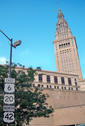
That is the last northbound US 42 marker. In the background is the Terminal Tower, a Cleveland landmark. The scene shown below is about three blocks ahead, approaching Ontario:
|

Fannin, July 2007
|
|
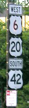
Despite the fact that three different signs are used to mark the routes involved here, there are still some additional state highways that are not referenced! This page concerns only US routes; here is a close-up of the first sign:
|
Morrison, Jul. 2007
|
|
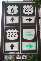
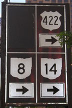
Based on the non-standard design, those signs were presumably put up by the City of Cleveland (as opposed to ODOT), and Marc has narrowed down the date of their installation to roughly 1980 (give or take a couple years). At this point, Superior is US 6-42, and originally US 20 probably did come to this point and then turn south on Ontario. But according to ODOT SLD's, US 20 actually splits off on W. Roadway, one block behind the camera. (Although there is no reason why US 20 cannot go south here and then east on South Roadway [which becomes Euclid Avenue]. However, there is no sign on southbound Ontario directing US 20 traffic to do that.) US 322 technically begins one block ahead, at E. Roadway, but it is appropriate to sign it there at the traditional terminus. There are other routes involved here -- too many for a single sign. Here is the next signboard:
|
Morrison, Jul. 2007
|
|
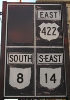
US 422 begins there, to the right on Ontario. The blank quadrant has a black panel covering a US 21 shield which pointed that direction as well. A similar US 21 shield is visible in this screen capture from a 1986 video:
|

c. 1986 (linked to source)
|
|
Despite the fact that US 21 was decommissioned in Ohio in 1967, the US 21 shields remained on display at this intersection for another three decades (until 1998 or 1999). Marc offers an explanation for this: he has found photos from both 1976 and 1978 showing standard (standalone) ODOT markers at this intersection, including one for US 21. He suspects that the creators of these "Public-Square-style" signs simply copied the routes that had formerly been posted at the intersection... including US 21, which ODOT had not replaced with SH 21 signs in a timely manner.
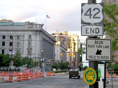
Anyway, the only US route that has not been mentioned yet is US 42 -- it has its own "End" assembly just ahead: |
Morrison, Jul. 2007
|
|
That was put up sometime between 2004 and 2006. Officially, US 42 ends one block past Ontario, at E. Roadway (the same place where US 322 begins), and signage installed in 2011 confirms that...
|

Fannin, Dec. 2012
|
|
...although it would have been nice to see the sign stay right at Ontario, the intended endpoint of US 42. Even more perplexing, though, is why the end of one route (US 42) is posted, but not any of the others that terminate here. Just ahead one finally reaches the intersection itself:
|

Google Maps Street View, Oct. 2007
|
|
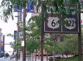
Just past Ontario is another "Public-Square-style" sign panel, this one stating that the traveler is on eastbound US 6 and eastbound US 322...
|
Karners, Aug. 2010
|
...even though drivers are not technically on 322 until one block ahead, at the E. Roadway intersection:
|
Google Maps Street View, Oct. 2007
|
|
Officially, that is the east end of US 42, and the west beginning of US 322. A few blocks ahead (just past the 9th Street intersection) there is a more standard reassurance assembly:
|

Hascall, Oct. 2007
|
Now, turning around and heading back west on Superior, US 322 ends at E. Roadway, and US 42 begins there...
|
Google Maps Street View, Oct. 2007
|
...however, unlike eastbound Superior, signage heading this direction is almost non-existent... which is perplexing, because in order to follow any route other than westbound US 6-20-42, one must make a complicated "Public-Square-left-turn" (described in the intro). One way to do that would be to turn right at this intersection, using E. Roadway and then Rockwell. But neither of those roads are actually on the state highway system, so maybe that is why this turn is not signed. However, there does appear to have been a half-baked attempt to sign that movement: heading north on E. Roadway, there is a "US 422 (left arrow)" sign. Then, heading west on Rockwell, there are signs directing OH 8-14 traffic to turn left on Ontario (but no mention of US 422).
|
Back to westbound Superior; one block ahead is Ontario:
|
Google Maps Street View, Oct. 2007
|
US 422 begins to the left, although one cannot make that movement at this intersection. US 21 also began that direction. This intersection was also the historic terminus of US 42 and US 322. Just ahead is the lone signage heading this direction:
|
Morrison, Jul. 2007
|
|
Marc reports that during the 1980s, that assembly was more of a "Public-Square-style" signboard (rather than the standard DOT assembly pictured above). Note that US 42 is signed "north-south" in Ohio. Now we will head south from Superior on Ontario:
|
Morrison, Jul. 2007
|
|
That is the first eastbound US 422 sign, and the blank spot contained the first southbound US 21 sign. Turning around (northbound on Ontario), we have lots of problems. Just past Prospect Avenue there's an assembly for "Jct. US 6 / US 20". But there is no sign afterward which directs eastbound US 20 traffic to turn right on South Roadway. Just past that intersection we have this signboard:
|
Fannin, Aug. 1999
|
|
US 322 begins to the right at the next intersection (Superior), and eastbound US 6 is that direction too. Westbound US 6-20-42 is to the left on Superior, but since drivers cannot turn that way, traffic is signed straight through Superior:
|
Google Maps Street View, Oct. 2007
|
That is the west end of US 422, and the historic north end of US 21. Historically, US 322 began to the right, while US 42 began to the left. But traffic is not allowed to make that movement, so the intention of the sign above is for drivers to make two lefts around Public Square, and then a right on Superior. But unfortunately, there is no follow-up signage ahead for that routing. And even if one correctly negotiates that movement, when they get back to Superior, signage is underwhelming...

Fannin, Aug. 1999
|
...no mention of US 20 or US 42. But historically those routes got a little more respect:
|

Diana McNees, The Cleveland Plain Dealer, Jan. 1978
|
That was taken from the same perspective (south on W. Roadway) by a newspaper photographer in 1978.
In summary, Public Square is a fascinating intersection: all the highways that converge here attest to its significance to the city of Cleveland. While highway signage does abound here, there are nevertheless several omissions, in addition to several idiosyncrasies and/or mistakes. |
Research and/or photo credits: Robert Droz; Marc Fannin; Dave Hascall; Karin and Martin Karner; Jeff Morrison; Greg Rider; Mike Roberson; Dale Sanderson
Page originally created 2007;
last updated Jun. 4, 2024.
last updated Jun. 4, 2024.
