End of US highway 33 |
 |
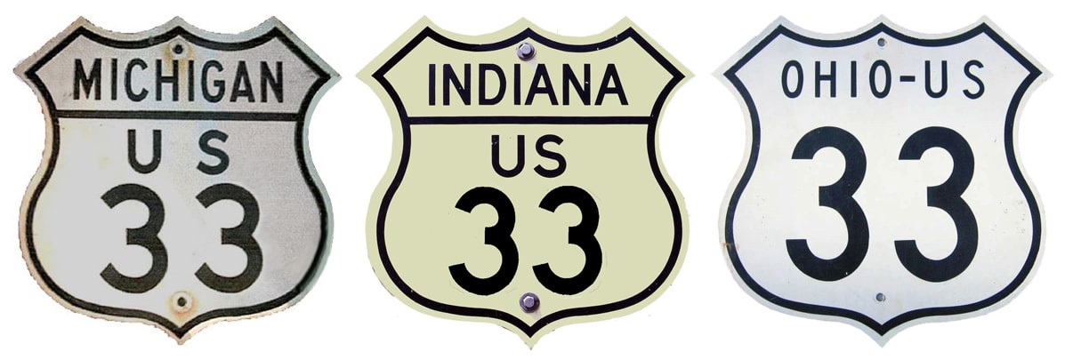
Summa
|
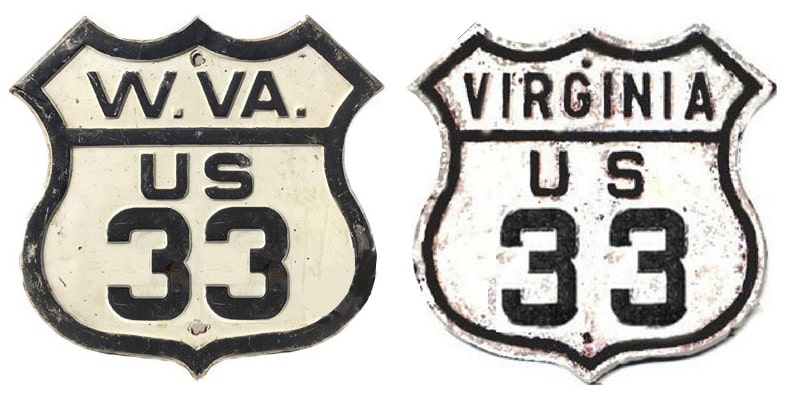
Summa
|
|
1937-1959
|
1959-1986
|
1986-1997
|
1997-present
|
Mileage: in 1989 AASHTO listed a figure of 732 miles for US 33... however, it is unclear where that number came from, because according to the state subtotals on AASHTO's 1989 spreadsheet, mainline US 33's actual end-to-end total at the time was 712 miles (or 714 including the mileage of US 33's associated business route). Our own 2020 measurement yielded 701.8 miles. At its maximum historic extent, US 33 was 764.9 miles long.
|
Note: despite the north-south bearing implied by its odd number, US 33 is signed north-south only in Indiana (and historically Michigan). The highway is signed east-west in Ohio, West Virginia, and Virginia.
|
|
|
The east end of US 33 has been in Richmond ever since the route was first commissioned in 1937. The north end of US 33 was originally in St. Joseph. From 1951 to 1960, US 33 ended at the intersection shown in this photo, which was looking north on Main Street (which historically carried US 12-31 traffic):
|
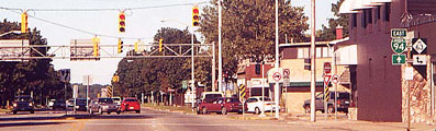
Fannin, Sep. 2000
|
|
US 33 came in from the right on Niles Avenue, and ended there. M-63 turns north and is co-signed with Business 94 through downtown. Originally that is what US 33 did, too, from 1935-1951. The designation ended where eastbound US 12 split off from northbound US 31 at Port Street. This photo was looking north on Main:
|
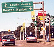
Fannin, Sep. 2000
|
Today Port is one-way westbound, so Business 94 heads east on Ship Street, one block to the south of Port. US 33 originally ended one block ahead, when Port ran both directions.
|
From 1959-1986, US 33 was signed yet further north. Whereas US 31 is now on a newer bypass to the west of Niles, it formerly overlapped with US 33 on 11th into downtown Niles. There, those two designations followed Main Street to the west, then Front Street northwest to Berrien Springs. In town, US 31-33 used Ferry Street and Cass Street, and then continued northwest into St. Joseph. Back then, today's US 12 was US 112; US 12 instead followed basically the same corridor as modern I-94 from Detroit through St. Joseph. There, US 12 was routed along today's Business I-94, and US 31-33 came in from the southeast on what is now MI hwy. 63. But in the early 1960s, US 31 was rerouted around St. Joseph/Benton Harbor via a new freeway (on which it is still routed today, but the road is now better known as I-94 and I-196). So then US 33 was signed along US 31's old route (modern M-63), along the shore of Lake Michigan all the way to its junction with the "new" US 31 at Lake Michigan Beach (today's I-196 interchange 7). Here is a map scan from that timeframe:
|
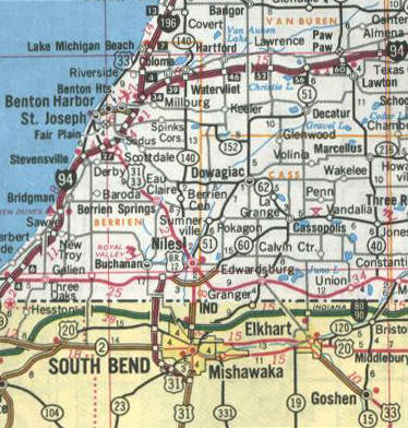
|
|
Note the US 33 shield way up by Lake Michigan Beach. This shot was looking north at the end of modern M-63:
|
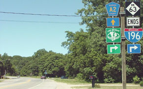
Sanderson, June 2001
|
|
That was formerly US 33; it took a right here and ended at US 31 (today's I-196). County road A2 (straight ahead) was the original route of US 31. This next shot was looking south on I-196/US 31. Back when this was just US 31, this exit marked the north beginning of US 33:
|
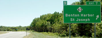
Sanderson, June 2001
|
From its current north end in Elkhart, US 33 extended further north along Main to Lusher Avenue, and then west. At Nappanee Street (IN hwy. 19), it jogged north across the railroad, and then west again on Lincolnway, following the route which is now signed IN hwy. 933 into South Bend. In downtown South Bend, IN 933 leaves Lincolnway to continue west on Sample Street, and then heads north via Michigan Street (southbound uses Main Street) and the Dixie Highway. At the Michigan line, the route becomes M-51; that was the former route of US 33. In June 1986, AASHTO approved truncating the US 33 designation to Niles; here is that agenda item from the meeting minutes:
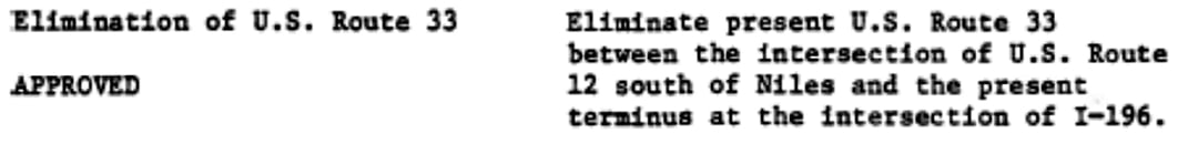
|
So US 33 terminated at the junction with modern US 12 (or the Pulaski Highway), which is a bypass outside Niles.
This next photo was taken looking west on US 12; for a time US 33 began by exiting to the right:
|

Nitzman, Jun. 2022
|
|
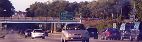
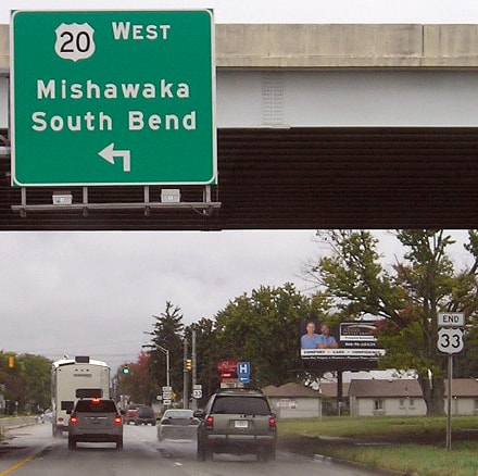
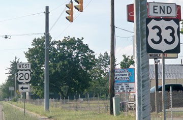
In 1997, the north end of US 33 was truncated again, this time to the outskirts of Elkhart, at its junction with modern US 20 (known locally as the St. Joseph Valley Parkway). These shots were taken approaching Elkhart from the south on US 33:
Morrison, Oct. 2013
|
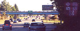
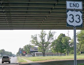
The green sign in the distance is shown more closely on these next two photos:
Fannin, Sep. 2000
Morrison, Oct. 2013
|
|
Strangely, visible in that last photo are not just one, but two, "End US 33" assemblies, shown close-up in these photos:
|
Karners, Jul. 2010
|
Karners, Jul. 2010
|
|
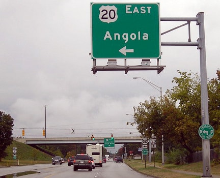
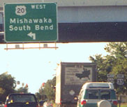
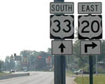
Heading the opposite direction (south out of downtown Elkhart on Main), one finds themselves at the north beginning of US 33 when they reach the US 20 interchange:
|
Fannin, Sep. 2000 (unchanged as of 2010)
|
Mortell, Aug. 2005 (unchanged as of 2010)
|
Research and/or photo credits: Chris Bessert; Marc Fannin; Karin and Martin Karner; Josh Lintz; Jeff Morrison; Robert Mortell; J.P. Nasiatka; Alex Nitzman; Dale Sanderson; Michael Summa
Page originally created 2000;
last updated Dec. 15, 2023.
last updated Dec. 15, 2023.
