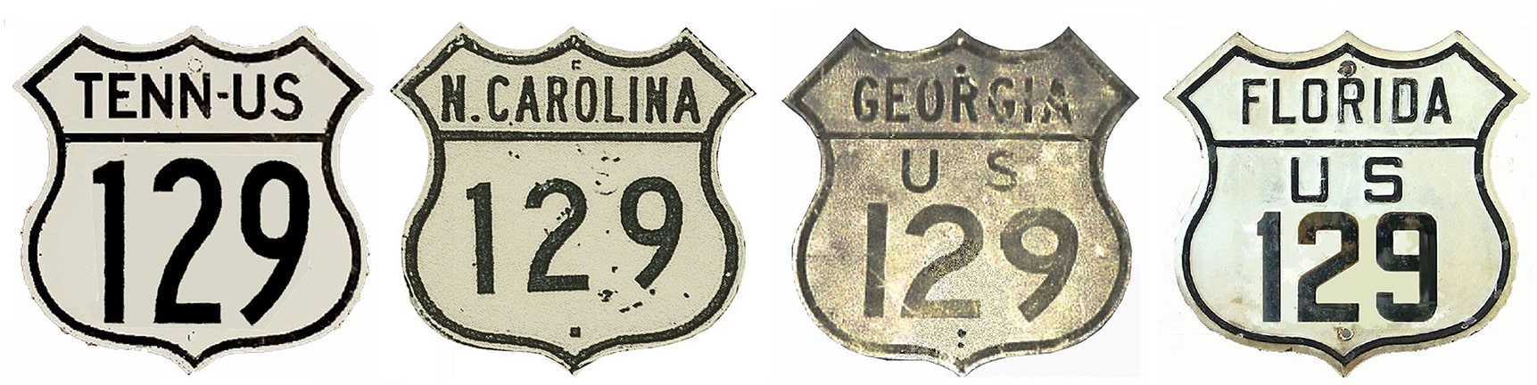
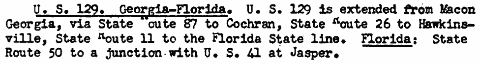
End of US highway 129 |
 |
|
1926-1930
|
1930-1934
|
1934-1940
|
|
1940-1947
|
1947-1958
|
1958-present
|
Summa
|
|
Mileage: in 1989 AASHTO listed a figure of 630 miles for US 129... however, that included the mileage of US 129's associated alternate route. According to the state subtotals on AASHTO's 1989 spreadsheet, mainline US 129's actual end-to-end total at the time was 582 miles. That closely matches our own 2020 measurement, which yielded 581.4 miles.
|
US 129 was there in the beginning, though it was a relatively short Georgia intra-state route (meeting its parent route, US 29, in Athens). In Macon, US 129 came into town on North Avenue, and then Spring Street down to Mulberry Street. It is possible that US 129 junctioned with US 41 and/or US 80 at that intersection (this map is not clear about intra-city routings):
|
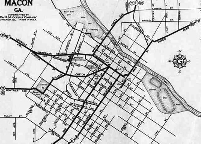
c. 1931, Gousha
|
|
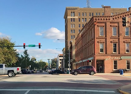
Regardless, given highway signage practices during that time period, it is almost certain that US 129 would have extended east on Mulberry, ending at the courthouse on 2nd Street:
Sanderson, Nov. 2017
|
This interactive image is looking the opposite direction (west on Mulberry), which was northbound US 41 and westbound US 80. It is uncertain whether one or both routes continued straight ahead on Mulberry, or angled to the left via Cotton Avenue. But it is very probable that the south beginning of US 129 was straight ahead on Mulberry (pan right to see the courthouse):
|
|
In Gainesville at the time, it was US 19 (not US 23) that ran through town. The north end of US 129 was at its junction with US 19:
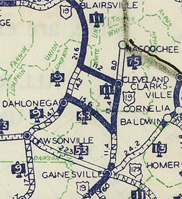
c. 1930, GA DoT
In those days, neither E.E. Butler Parkway nor Jesse Jewell Parkway had been built yet. Rather, historic maps indicate that US 19 used Spring Street through town, and that US 129 came in on Athens Highway and Green Street.
|
This image was looking north on Green; the half-block just before reaching Spring (the cross street) has since been closed to vehicles, but just ahead (at the location of the archway) was where US 129 originally ended at US 19:
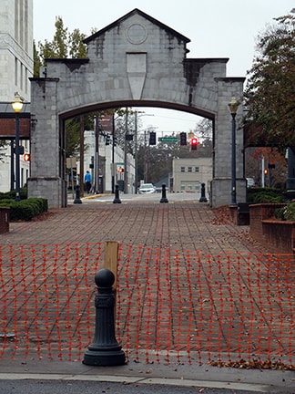
Sanderson, Nov. 2017
|
In 1931, US 19 was rerouted such that it bypassed Gainesville, instead passing through Dahlonega and Dawsonville. The US 23 designation was extended into Georgia, carrying traffic through Gainesville. US 129 was extended north along the former US 19 through Cleveland. It ended at its junction with US 19 northwest of town, at an intersection known as Turners Corner:
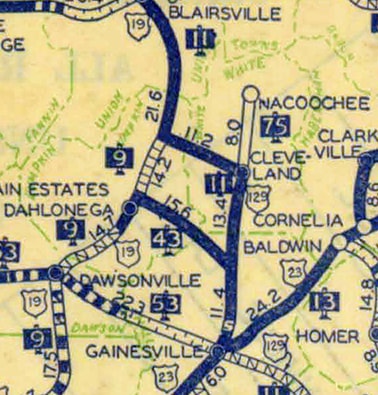
c. 1932, GA DoT
|
This image was taken looking north on US 129. To the left is southbound US 19, and northbound is straight ahead. Today US 129 continues ahead with US 19, but during the early 1930s, this was the north end of US 129:
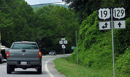
Lintz, Aug. 2020
|
|
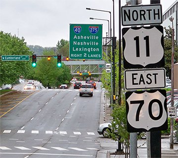
That terminus did not last for long, either: in 1935 the north end of US 129 was extended to Knoxville. Before it had been routed onto the modern four-lane between Knoxville and Maryville, US 129 ran along what is now TN secondary hwy. 33, or the Maryville Pike. At Chapman Highway/Henley Street (which is now US 441), traffic was directed north into downtown Knoxville, ending either at Main Street or Cumberland Avenue (depending which historic maps were correct). This one indicates that US 11-70 remained on Cumberland...
|
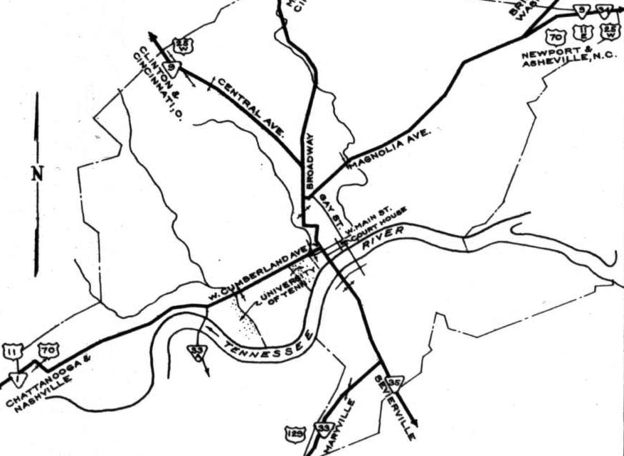
c. 1938, TN DoT
|
|
...but this one shows that traffic veered onto Main to connect with Henley:
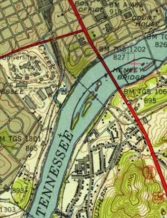
c. 1942, USGS
|
This shot was taken from a vantage point between Main and Cumberland, looking north on Henley. Today northbound US 11 and eastbound US 70 come in from the left on one-way Main Street (one block behind the camera), and are then routed north here onto Henley, along with US 441. But there was no US 441 here at the time when US 129 ended here:
Karners, Apr. 2014
|
|
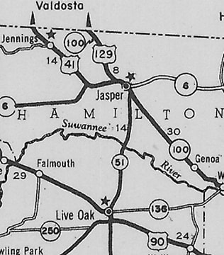
In 1941 the south end of US 129 was extended to US 41 at Jasper:
c. 1946, FDoT
|
This shot was looking west on northbound US 41-129. It was taken just a few years after US 129 had been extended further south (behind the camera), but this is almost certainly how the junction looked when the south beginning of US 129 was to the right:
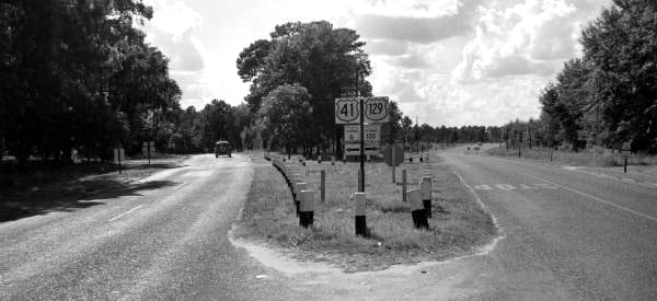
c. 1953, Florida State Road Dept. (linked to source)
|
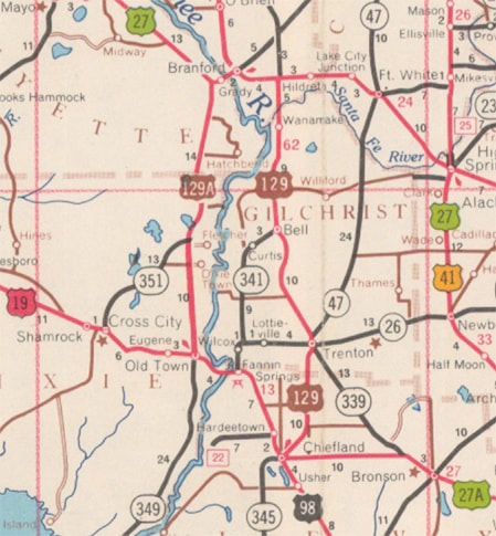
Then in 1947 the designation was extended further south: behind the camera for a short distance, then through Live Oak to Branford. From there, US 129 followed what is now FL hwy. 349 to Old Town, ending at its junction with US 19:
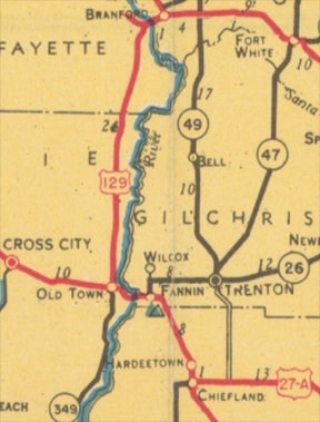
c. 1949, FDoT
|
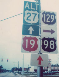
This shot was looking east on US 98, which is also southbound US 19-27A:
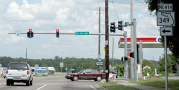
Nitzman, July 2007
In 1947 that was only US 19, and for about the next decade, the south beginning of US 129 was to the left on today's FL 349. The sign for northbound traffic is essentially the same:
|
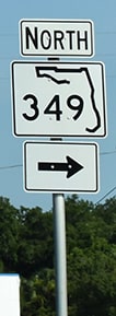
Nasiatka / Nitzman, Jul. 2022
|
|
Then in 1959, US 129 was rerouted along its present course south of Branford, ending at its current terminus in Chiefland. Meanwhile, its former corridor between Branford and Old Town was designated Alt. US 129:
c. 1960, FDoT
|
Here are a couple views looking northwest on Young Boulevard (or northbound Alt. US 27 as well as US 19-98, which joined this road just behind the camera:
Summa, 1978
Nasiatka/Nitzman, Apr. 2019 (essentially unchanged since at least 2003)
|
|
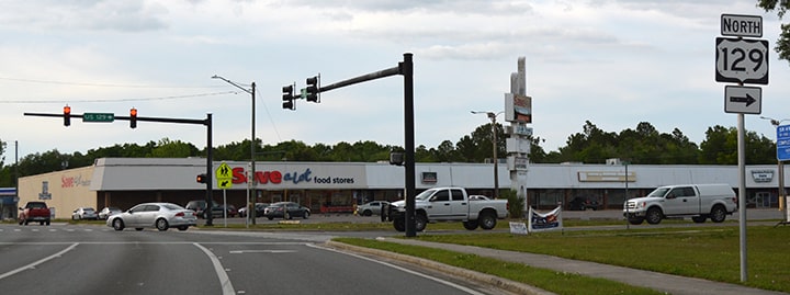
Almost all colored shields in Florida have long since been replaced. US 129 begins to the right on Rodgers Boulevard; here is a view from the opposite direction...
Nitzman, Nov. 2014 (essentially unchanged since at least 2006)
|
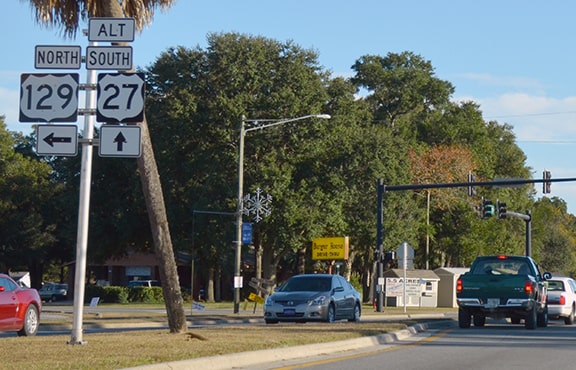
...and for drivers who turn to the north there, the first confirming assembly looks like this:

Nasiatka/Nitzman, Apr. 2019 (essentially unchanged since at least 2006)
|
|
Heading the opposite direction, there was no "End" sign, but this assembly was posted at US 129's south terminus. The green sign in the distance points left to Inglis, Cedar Key, and St. Petersburg; and Fanning Springs to the right.
|
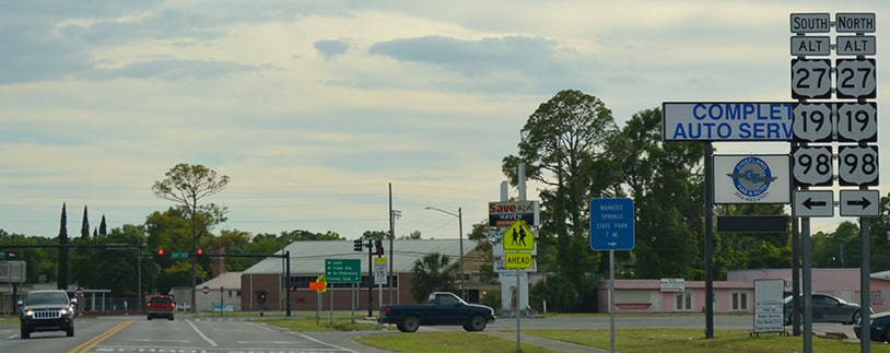
Nasiatka/Nitzman, Apr. 2019 (essentially unchanged since at least 2006)
|
Back to the north end of US 129 in Knoxville: in 1961 AASHO approved TNDoT's request to reroute US 129 traffic off Maryville Pike and onto Alcoa Highway. However, at the time there was no I-40, so Alcoa ended at what was then US 11-70 (Cumberland Av/Kingston Pike). That arrangement lasted for only a few years, and I have not yet found a map that illustrates US 129 ending there. But the following map was published just a few years prior (1956), and it shows where US 129 ended starting in 1961, when it was rerouted over TN hwy. 73:
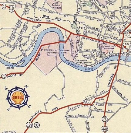
c. 1956, Gousha
|
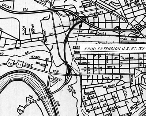
In 1966 TNDoT extended Alcoa Hwy to then-new I-40 (so now there is a grade-separated interchange at Kingston Pike, meaning that junction looks a lot different now than it did when US 129 ended there). This map was included in TNDoT's application to have AASHO extend the US 129 designation along the new segment:
c. 1966, TNDoT
|
|
This photo was taken about four decades later, and it shows what was at the time the northernmost trailblazer:
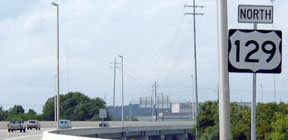
Patriarca, summer 2003
|
Just ahead, there was no "End" signage where US 129 terminates at I-40's interchange 386B:
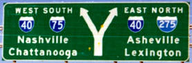
Sanderson, Oct. 2000
|

Patriarca, summer 2003
|
|
Heading out of downtown Knoxville on westbound I-40, the signs shown here mark the exit to the north beginning of US 129:
|
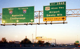
Sanderson, Oct. 2000
|
Patriarca, summer 2003
|
|
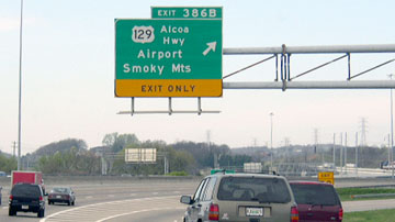
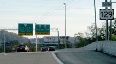
Here is the signage from the opposite direction (eastbound I-40)...
|
Patriarca, summer 2003
|
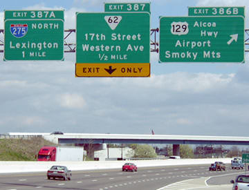
...and drivers taking that exit soon see the first US 129 trailblazer:
Ivy/Nitzman, 2009
|
Ahead, US 129 serves the Knoxville airport, which is actually closer to Maryville. South of Maryville, 129 heads into the hills and skirts the south edge of Great Smoky Mountains National Park. It is a winding road, and 40 mph is about the most travelers can do in many places.
Research and/or photo credits: Justin Cozart; Nathan Edgars; Brent Ivy; Karin and Martin Karner; Josh Lintz; J.P. Nasiatka; Alex Nitzman; Chris Patriarca; Mike Roberson; Dale Sanderson; Michael Summa
Page originally created 2000;
last updated Aug. 2, 2022.
last updated Aug. 2, 2022.
