End of US highway 34 |
 |
|
1926-1933
|
1933-1935
|
1935-1938
|
1938-1970
|
1970-present
|
Mileage: in 1989 AASHTO listed a figure of 1122 miles for US 34... however, the distance has actually increased since then (because of a reroute in Iowa and Nebraska). As of 2020, US 34 measured 1127.8 miles in total length. Historically, when it went to downtown Chicago, US 34 was 1138.4 miles long.
Summa
|
|
Claim to fame: US 34 reaches the highest elevation of any US route: 12,183' along Trail Ridge Road through Rocky Mountain National Park in Colorado... although that segment of US 34 is open only during the summer months. For most of the year, an approx. 24-mile segment through the Park is closed to traffic.
|
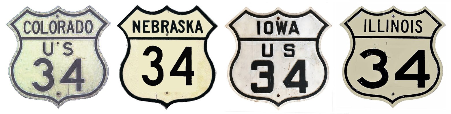
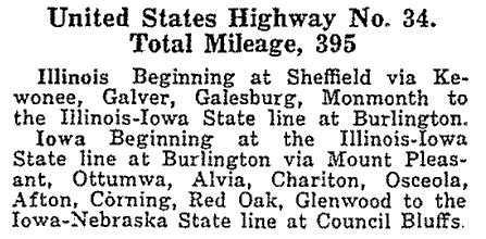
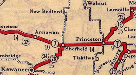
US 34 was among the original 1926 routes, but it ran only from Council Bluffs to historic US 32 in Sheffield. This route description is from AASHO's Apr. 1927 route log:
|
c. 1927, Rand McNally
|
|
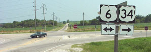
This photo was looking north at the intersection where US 34 joins US 6; Sheffield is about a half-mile to the right:
|
Sanderson, June 2001
|
|
Back in the early 1930s, it was US 32 running across this photo instead of US 6, and US 34 ended here. The next shot is looking west on US 6-34 at the same intersection. This was formerly US 32, and the east beginning of US 34 was to the left:
|
Sanderson, June 2001
|
|
Maps from the mid-1930s show that the east end of US 34 had been extended to Chicago, and that the route's west end was extended to Grand Island:
|
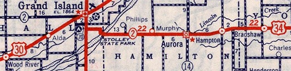
c. 1939, Rand McNally
|
|
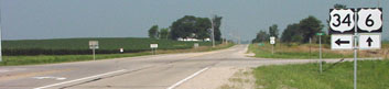
It is possible that this photo shows the former west end of US 34. It was taken looking west on US 34/NE hwy. 2 (Husker Highway) at the Locust Street intersection:
|
Sanderson, June 2001
|
|
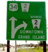
Today US 281 is routed on a newer bypass about 2 miles ahead -- but before that was built, US 281 was on Locust. So US 34 could have ended there, but it is more likely that it turned right with 281 for about 2 miles, ending downtown at its junction with US 30. The next photo, then, was looking east on First Street downtown (US 30). The next intersection is Walnut Street, and it is possible that the west beginning of US 34 was to the right:
|
Sanderson, June 2001
|
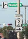
Sanderson, June 2001
Walnut curves into Locust a few blocks to the right.
|
|
In 1938 the west end of US 34 was extended to its current terminus. The highway goes over Trail Ridge Road in Rocky Mountain National Park. On the west side of the Continental Divide, after passing through Grand Lake, the last westbound marker was posted in a strange place:
|
Sanderson, Dec. 2005
|
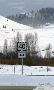
That was just past the junction with County Road 6, but just before CR 40. Some of those signs would be more useful if they were posted on the far side of the intersection ahead.
|
In this area US 34 more or less follows the headwaters of the Colorado River down to its confluence with the Fraser River. US 40 follows the Fraser all the way down from the Great Divide at Berthoud Pass to its mouth near Granby, where it empties into the Colorado. At this junction, US 34 ends, and US 40 continues downstream along the Colorado. These photos show the sign one would see at the approach to the stop sign at US 40:
|
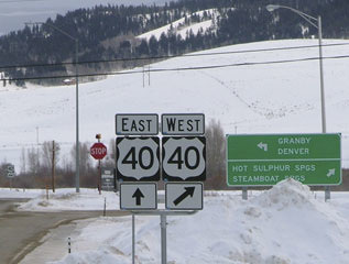
Sanderson, Dec. 2005 (unchanged as of Oct. 2010)
|
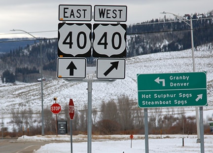
Sanderson, Dec. 2017
|
|
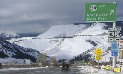
CDoT does not sign most of its US route termini, and US 34 is no exception. A driver sitting at the stop sign just ahead can only assume that the sign shown here (on the far side of the road) must mean that US 34 is all behind them:
|
Sanderson, Dec. 2005 (unchanged as of 2010; US 40 shield gone as of 2017)
|
The following shots were taken from eastbound US 40:

Elbert, July 2005
|
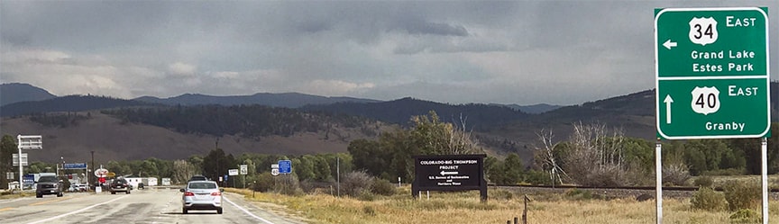
Sanderson, Aug. 2017
|
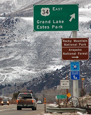
Visible in the background of those photos is a large overhead sign for traffic heading the opposite direction (west on US 40). The front side of that sign is shown here:
|
Sanderson, Dec. 2005 (unchanged as of Oct. 2010)
The light blue sign shows a Columbine (Colorado's state flower), which is used to denote the state's official "Scenic Byways". The dark blue sign gives the name of this specific route ("Colorado River Headwaters") and points out directions:
|
Sanderson, Dec. 2017
|
|
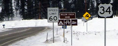
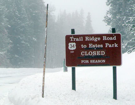
If a traveler took that right turn, they were soon greeted by the mileage sign shown here:
|
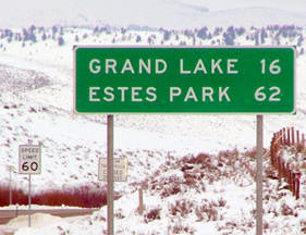
Sanderson, Dec. 2006
|
The control point "Estes Park" on these signs is interesting: that is correct only during summer weather. For the majority of the year, it is not possible to get to Estes that way, as evidenced by the sign posted just beyond the "Speed Limit 60" sign:
|
Sanderson, Dec. 2005
|
|
By 2017 that green mileage sign had been replaced by one with control points that were applicable year-round...
|
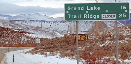
Sanderson, Dec. 2017
...and the first eastbound US 34 confirming marker was replaced by one that included an "EAST" tab:
|
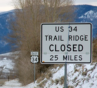
Sanderson, Dec. 2017
|
|
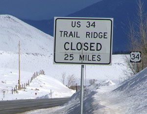
In a practical sense, US 34 is more often than not a route with two disconnected segments, separated by a gap through Rocky Mountain National Park. During the snow season, one can drive past the turnoff to Grand Lake, and sometimes up to ten miles north of the RMNP entrance station. But that is where the road is closed: if one is trying to connect with US 34 in Estes Park, they will need to turn around, and then they are looking at a drive of about four hours!
|
Sanderson, Dec. 2006
|
Snow removal crews strive to have Trail Ridge Road open by Memorial Day, but it is usually closed again by sometime in October. In other words, this westernmost 25-mile stretch of US 34 is isolated from the rest of the highway for about seven months out of each year. For more information about this part of US 34, check out this blog post.
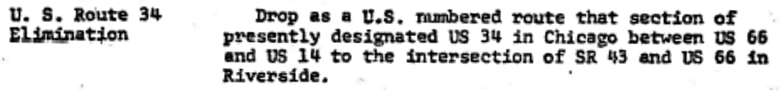
In 1970, the US 34 designation was removed from downtown Chicago and truncated back to the intersection where it split from US 66. Below is one of the agenda items from AASHO's meeting in November of that year:
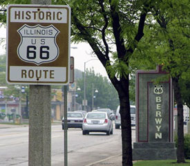
Despite the fact that US 66 itself was removed from the Chicago area a few years later (in 1977), the US 34 designation was not re-extended along its former route into downtown Chicago. Rather, US 34 still ends at the same place, at its historic junction with US 66, shown below:
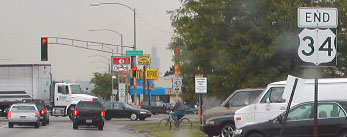
Bratney, June 2002
|
Sanderson, May 2005
|
|
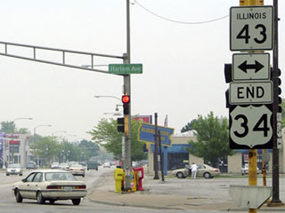
Those were looking east on Ogden Avenue, just shy of where that road intersects Harlem Avenue (or IL hwy. 43). There are not many instances like this, where a US route ends at a state highway. Today, if one continues straight ahead on Ogden, they are no longer on a state highway, but they are on a segment of historic US 66 -- a fact not lost on the city of Berwyn:
|
Sanderson, May 2005
|
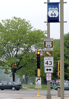
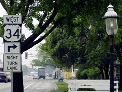
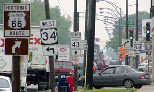
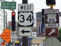
Old 66 appears to be well-signed throughout Chicagoland. Heading the opposite direction on Ogden, the series of signs one encounters is shown here...
Sanderson, May 2005
|
Sanderson, May 2005
|
Sanderson, May 2005
|
|
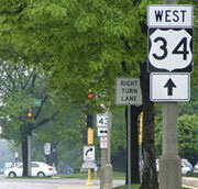
That easternmost segment of US 34 serves as the boundary between the villages of Riverside (to the north) and Lyons (south). This shot is from southbound Harlem; today the US 34 designation begins to the right:
|
Sanderson, May 2005
|
|
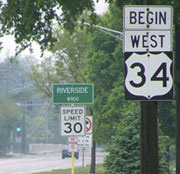
These shots are from the opposite direction (north on Harlem):
|
Sanderson, May 2005
|
Sanderson, May 2005
|
Note the historic US 66 markers; as previously mentioned, US 34 formerly continued east (right) with US 66 into downtown Chicago.
Research and/or photo credits: Neil Bratney; Chris Elbert; Jeff Morrison; Dale Sanderson; Michael Summa
Page originally created 1998;
last updated Dec. 15, 2023.
last updated Dec. 15, 2023.
