US Ends .com
  • Home
  • Store
    • US highway book
    • US highway map
    • Florida US highway map
  • Endpoints
    • US 1 - US 9 >
      • 1 >
        • 201
        • 301
        • 401 [i]
        • 401 [ii]
        • 401
        • 501
        • 601
        • 701
      • 2w >
        • 102
      • 2e >
        • 202
        • 302
      • 3
      • 4 >
        • 104
      • 5
      • 6 >
        • 106
        • 206
      • 7
      • 8
      • 9 >
        • 109*
        • 209
        • 309
    • US 10 - US 19 >
      • 10 >
        • 110
        • 210
        • 310
        • 410
      • 11 >
        • 111
        • 211
        • 311
        • 411 [i]
        • 411 [ii]
        • 411
        • 511*
        • 611
        • 711*
      • 12 >
        • 112
        • 212
        • 312
      • 13 >
        • 113
        • 213
      • 14
      • 15
      • 16 >
        • 116
        • 216
      • 17 >
        • 17-1
        • 117 [i]
        • 117
        • 217
      • 18 >
        • 118
        • 218
      • 19 >
        • 119
        • 219
        • 319
    • US 20 - US 29 >
      • 20e >
        • 120
        • 220
        • 320
        • 420
      • 20w
      • 21 >
        • 121 [i]
        • 121
        • 221
        • 321
        • 421
        • 521
      • 22 >
        • 122 [i]
        • 122 [ii]
        • 222
        • 322
        • 422e
        • 422w
        • 522
        • 622*
      • 23 >
        • 123 [i]
        • 123
        • 223
      • 24 >
        • 124
        • 224
      • 25
      • 26 >
        • 126
      • 27 >
        • 127
        • 227
      • 28
      • 29 >
        • 129
    • US 30 - US 39 >
      • 30 >
        • 130
        • 230
        • 330
        • 430
        • 530
        • 630*
        • 730
        • 830
      • 31 >
        • 131
        • 231
        • 331 [i]
        • 331
        • 431
      • 32
      • 33
      • 34
      • 35
      • 36 >
        • 136
      • 38 >
        • 138
    • US 40 - US 49 >
      • 40 >
        • 140
        • 240
        • 340
      • 41 >
        • 141
        • 241 [i]
        • 241 [ii]
        • 341
        • 441 >
          • 441n
          • 441s
        • 541
        • 641
      • 42
      • 43
      • 44
      • 45
      • 46
      • 48 [i]
      • 48 [ii]
      • 48
      • 49
    • US 50 - US 59 >
      • 50 >
        • 150
        • 250
        • 350
        • 450
        • 550
        • 650
      • 51 - 55 >
        • 51 >
          • 151
        • 52 >
          • 152
        • 53
        • 54 >
          • 154
        • 55
      • 56 >
        • 156
      • 57
      • 58 >
        • 158
        • 258
      • 59 >
        • 159
        • 259
    • US 60 - US 69 >
      • 60 >
        • 160
        • 260
        • 360
        • 460
      • 61 - 65 >
        • 61 >
          • 161
        • 62
        • 63 >
          • 163 [i]
        • 64 >
          • 164 [i]
          • 164 [ii]
          • 264
        • 65 >
          • 165
      • 66 >
        • 166
        • 266
        • 366 [i]
        • 366 [ii]
        • 466 [i]*
        • 466 [ii]
        • 566
        • 666
      • 67 >
        • 167
      • 68 >
        • 168
      • 69 >
        • 169
    • US 70 - US 79 >
      • 70 >
        • 170
        • 270 [i]*
        • 270
        • 370
        • 470
      • 71 >
        • 171
        • 271
        • 371 [i]
        • 371 [ii]
        • 371
      • 72 - 76 >
        • 72
        • 73
        • 74
        • 75 >
          • 175
          • 275
        • 76 >
          • 176
          • 276
      • 77 >
        • 177
        • 277
        • 377
      • 78 >
        • 178
        • 278
        • 378
      • 79
    • US 80 - US 89 >
      • 80 - 84 >
        • 80 >
          • 180 [i]
          • 180
          • 280
          • 380
        • 81 >
          • 181
          • 281
        • 82
        • 83 >
          • 183
          • 283
          • 383
        • 84
      • 85 - 89 >
        • 85 >
          • 185
          • 285 [i]
          • 285
          • 385 [i]
          • 385
          • 485
        • 87 >
          • 187
          • 287n
          • 287s
        • 89n
        • 89s >
          • 189 [i]
          • 189
    • US 90 - US 99 >
      • 90 - 94 >
        • 90 >
          • 190
          • 290
        • 91 >
          • 191 >
            • 191n
            • 191s
          • 491
        • 92 >
          • 192
        • 93
        • 94
      • 95 -98 >
        • 95 >
          • 195
          • 295
          • 395
        • 96 [i]
        • 96
        • 97 >
          • 197
        • 98
      • 99 >
        • 199
        • 299
        • 399
    • Anomalies >
      • 101
      • 163
      • 400
      • 412
      • 425
  • Places
    • A-L >
      • A >
        • Aberdeen
        • Albuquerque
        • Amarillo
        • Apalachicola
        • Astoria
        • Atlantic
      • B >
        • Baltimore
        • Baton Rouge
        • Bay Area
        • Bishop
        • Boone
        • Brady
        • Bristol
        • Brownsville
        • Brunswick
      • C >
        • Charleston
        • Chattanooga
        • Chicago
        • Cincinnati
        • Cleveland
        • Cody
        • Corpus
        • Cortez
        • Council Bluffs
        • Covington
        • Crescent
        • Cumberland Gap
      • D-E >
        • Dallas
        • Des Moines
        • Detroit
        • Dothan
        • Douglas
        • El Paso
        • Erie
        • Eugene
      • F >
        • Farmington
        • Flagstaff
        • Florence
        • Fox Valley
        • Franklin
      • G >
        • Gallup
        • Georgetown
        • Grand Junction
        • Grand Portage
        • Grayling
        • Great Falls
        • Greeley
      • H-I >
        • Hardeeville
        • Harrisburg
        • Holbrook
        • Idaho Falls
        • Int'l Falls
      • J-K >
        • Jacksonville
        • Joplin
        • Junction
        • Kansas City
        • Keokuk
        • Key West
        • Kingman
      • L >
        • Laredo
        • Lewiston
        • Long Beach
        • Los Angeles
        • Louisville
        • Lubbock
    • M-R >
      • M >
        • Mackinaw
        • Madison
        • Maryhill
        • Maysville
        • Miami
        • Midway
        • Miles City
        • Milford
        • Milwaukee
        • Minneapolis
        • Mobile 31
        • Mobile 31-43-45
        • Montgomery
        • Monticello
        • Mount Vernon
      • N-O >
        • Nags Head
        • Naples
        • Natchez
        • New Castle
        • New Orleans
        • Niagara
        • Norlina
        • Ocean City
        • Oklahoma City
      • P >
        • Pee Dee
        • Pembina
        • Pensacola
        • Petersburg
        • Philadelphia
        • Piegan
        • Pineville
        • Port Arthur
        • Portsmouth
      • Q-R >
        • Quad Cities
        • Rapid City
        • Raton
        • Reading
        • Richmond
        • Rockingham
        • Rouses Point
    • S-Z >
      • S >
        • San Antonio
        • San Antonio NM
        • San Diego
        • Santa Fe
        • Savannah
        • Sioux
        • Springer
        • Springfield
        • St. Ignace
        • St. John
        • St. Paul
        • St. Pete
      • T-U-V >
        • Tallahassee
        • Tampa
        • Toledo
        • Trinidad
        • Tuba City
        • Ucolo
        • VA Beach
      • W >
        • Walterboro
        • Waverly
        • West Memphis
        • Wilmington
        • Wilson
        • Wrightsville
      • Y >
        • Yellowstone E
        • Yellowstone N
        • Yellowstone NE
        • Yellowstone S
        • Yellowstone W
  • Highways
    • Map of all endpoints
    • Sources
    • History
    • 1926 almost-routes
    • Intra-state routes
    • Numbering
    • Colors
    • Gaps
    • Blog
  • Bonus
    • Colorado >
      • Lowest point
      • Antipodes
      • Toponymy >
        • Roots
      • Colloquialisms
      • Populations
      • Denvers
    • Washington Meridian
    • Watersheds >
      • Headwaters Hill
      • Three Waters Mtn.
      • Parting of the Waters
    • Geo-centers >
      • 48 states
      • 50 states
      • North America
    • State corners >
      • AZ-CO-NM-UT
      • CO-UT-WY
      • CO-NE-WY
      • CO northeast
      • CO-KS-NE
      • CO-KS-OK
      • CO-NM-OK
      • NM-OK-TX
      • NM southeast
      • TX northwest
  • Connect
    • Author/history
    • Rationale
    • Contact
    • Contributors
    • Submissions

A dubious US highway endpoint in Mena, AR

1927-1930
View a map showing this route.
Get your very own map showing all current and historic US routes!

Picture
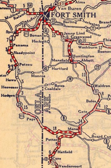
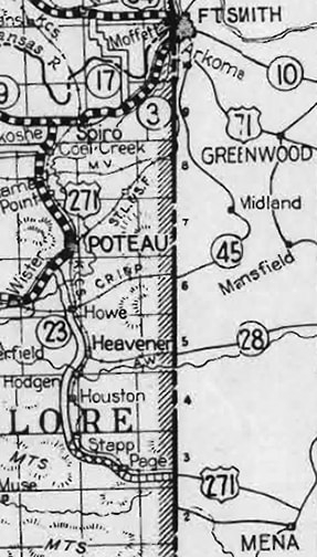
c. 1927, Rand McNally
US 271 was among the routes included in AASHO's original 1926 log.  Its endpoints were listed as Ft. Smith and Mena, and its route was shown on some maps from that timeframe.  In late 1929, US 271 was changed such that it no longer entered Arkansas at all.  That would have left an orphaned segment between Poteau OK and Mena AR, but AASHO told both Arkansas and Oklahoma to use the US 371 designation for that segment.  However, there are several reasons to suspect that neither US 271 nor US 371 were ever actually signposted along the Arkansas section (between Mena and the Oklahoma line).

Ft. Smith and Mena are both in Arkansas, and they were (and still are) served by US 71.  The distance between those two towns is about 80 miles along a segment of US 71 which remains entirely within Arkansas.  

US 271 was also described as an 80-mile route in the AASHO log, although the actual distance would have been more like 86 miles.  And the majority of that route (about 63 miles) went through Oklahoma.

Especially during those early years, the US routes were expected to carry the main flow of traffic.  Community leaders wanted a US highway to run through their town, in order to reap the anticipated economic benefits.  In this specific case, Oklahoma would have wanted AASHO to route US 71 traffic through Poteau and Heavener.  Failing that, they would have wanted a different US route designation to pass through their state, one that travelers would view as an alternate route to US 71.  AASHO probably approved the US 271 designation as a concession to Oklahoma.  But Arkansas, on the other hand, would have wanted traffic to remain in their state, and would not have been motivated to inform travelers about an alternate route through Oklahoma.

It was probably a result of these conflicting interests that, during that timeframe, official maps from each state showed significant discrepancies in route information.  Once the US routes had been approved, the next issue of Oklahoma's map actually showed US 71 running through their state!
Picture
c. 1927, OK DoT
The Arkansas map from the same year showed US 71 going through their state, and it made no reference to US 271 going into Oklahoma:
Picture
c. 1927, AHTD
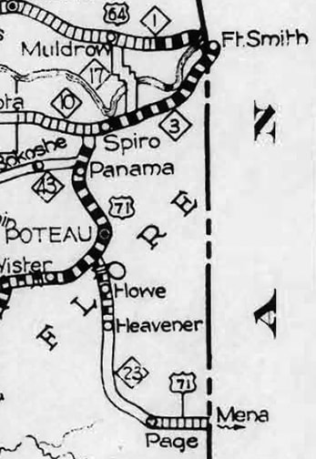
The next issue of Arkansas' map (1928) was essentially unchanged.  The fact that US 271 was not shown on their maps may have been an indication that Arkansas was not signposting the route in the field.  Meanwhile, Oklahoma probably received a stern reprimand from AASHO, pointing out that US 71 did not run through their state.  The 1928 issue of their map dutifully showed this, while the "concession route" was labeled as US 271...
Picture
c. 1928, OK DoT
...however, notice that after going through Page, US 271 was shown to connect with US 71 southwest of Mena.  That would not have been possible, because the road through Page (today's US 59-270) connects with US 71 to the northeast of Mena.  That was corrected on the following issue of Oklahoma's map:
Picture
c. 1929, OK DoT

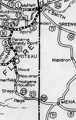
Arkansas' version from the same year was their only map that referenced US 271...
Picture
c. 1929, AHTD
...but note that it was not labeled anywhere east of the state line.  Also notice that it showed US 271 joining US 71 southwest of Mena.  If that had been the case, then US 271 would not have gone through Page.  Instead it would have gone south from Zoe to Big Cedar, then eastward (via today's OK 63 and AR 8).  So it appears that the two states had a disagreement not only about the designation of this highway, but also about its corridor.  All of this provides further cause for suspicion that Arkansas was not signposting US 271.

It should be noted that, during this same timeframe, both Oklahoma and Arkansas were petitioning AASHO for a new US route, which would eventually be approved and christened US 270.
Get your copy of this epic book that commemorates the first century of the US route system!

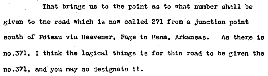
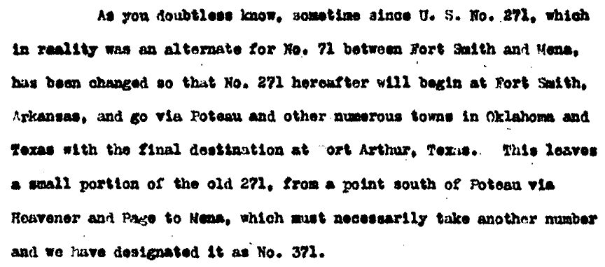
Oklahoma apparently decided it could not benefit from the US 271 designation if Arkansas was not going to sign it.  So it appears Oklahoma petitioned to apply US 271 shields to a different corridor, heading southwest from Poteau and into Texas (a state that was much more willing to cooperate than Arkansas, considering that they extended US 271 all the way to the Gulf).  AASHO approved that change in late 1929, and they told both Oklahoma and Arkansas to apply the "US 371" designation to the corridor between Poteau and Mena.  ​Following is an excerpt from the letter AASHO sent to Oklahoma on Dec. 7, 1929...
Picture
...and the letter below was sent to Arkansas on the same date:
Picture
The AASHO archive does not contain any response from Arkansas.  But Oklahoma did respond, and then in April 1930 they stated that the road had been signposted as US 371:
Picture
 The 1930 map referenced in that letter is shown below; it was the only version of Oklahoma's official state highway map that illustrated US 371:
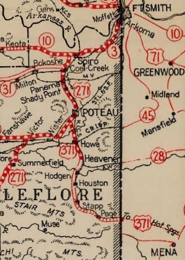
Picture
c. 1930, OK DoT
Arkansas' map from the same year agreed with the rerouted US 271, but it did not label US 371:
Picture
c. 1930, AHTD
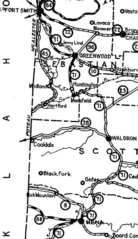
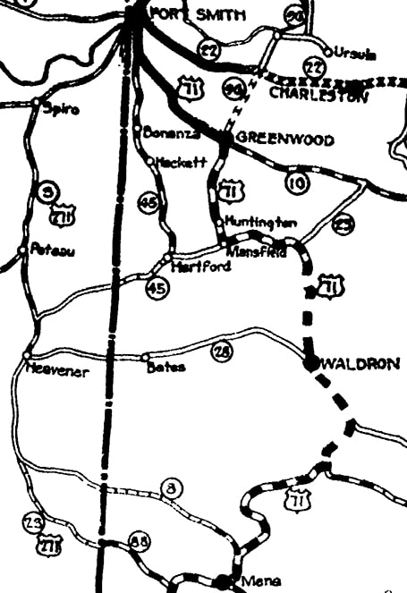
US 270 was approved in May 1930, subsuming all of US 371 between Mena and Poteau.  Oklahoma's map from the following year (1931) illustrated that, and the 1932 Arkansas map followed suit.  So US 371 existed for about six months, and it was apparently signposted in Oklahoma.  But the main point of this page is to demonstrate reasons why neither US 271 nor US 371 may have ever been signposted to the southern terminus near Mena.  For additional maps and research, please see this blog post by Jeremy Lance.
Main US 271 page
Main US 371 page
Research and/or photo credits: Jeremy Lance; Dale Sanderson
Page originally created 2010;
last updated Dec. 7, 2023.
Copyright © 1998-2025
Picture