US Ends .com
  • Home
  • Store
    • US highway book
    • US highway map
    • Florida US highway map
  • Endpoints
    • US 1 - US 9 >
      • 1 >
        • 201
        • 301
        • 401 [i]
        • 401 [ii]
        • 401
        • 501
        • 601
        • 701
      • 2w >
        • 102
      • 2e >
        • 202
        • 302
      • 3
      • 4 >
        • 104
      • 5
      • 6 >
        • 106
        • 206
      • 7
      • 8
      • 9 >
        • 109*
        • 209
        • 309
    • US 10 - US 19 >
      • 10 >
        • 110
        • 210
        • 310
        • 410
      • 11 >
        • 111
        • 211
        • 311
        • 411 [i]
        • 411 [ii]
        • 411
        • 511*
        • 611
        • 711*
      • 12 >
        • 112
        • 212
        • 312
      • 13 >
        • 113
        • 213
      • 14
      • 15
      • 16 >
        • 116
        • 216
      • 17 >
        • 17-1
        • 117 [i]
        • 117
        • 217
      • 18 >
        • 118
        • 218
      • 19 >
        • 119
        • 219
        • 319
    • US 20 - US 29 >
      • 20e >
        • 120
        • 220
        • 320
        • 420
      • 20w
      • 21 >
        • 121 [i]
        • 121
        • 221
        • 321
        • 421
        • 521
      • 22 >
        • 122 [i]
        • 122 [ii]
        • 222
        • 322
        • 422e
        • 422w
        • 522
        • 622*
      • 23 >
        • 123 [i]
        • 123
        • 223
      • 24 >
        • 124
        • 224
      • 25
      • 26 >
        • 126
      • 27 >
        • 127
        • 227
      • 28
      • 29 >
        • 129
    • US 30 - US 39 >
      • 30 >
        • 130
        • 230
        • 330
        • 430
        • 530
        • 630*
        • 730
        • 830
      • 31 >
        • 131
        • 231
        • 331 [i]
        • 331
        • 431
      • 32
      • 33
      • 34
      • 35
      • 36 >
        • 136
      • 38 >
        • 138
    • US 40 - US 49 >
      • 40 >
        • 140
        • 240
        • 340
      • 41 >
        • 141
        • 241 [i]
        • 241 [ii]
        • 341
        • 441 >
          • 441n
          • 441s
        • 541
        • 641
      • 42
      • 43
      • 44
      • 45
      • 46
      • 48 [i]
      • 48 [ii]
      • 48
      • 49
    • US 50 - US 59 >
      • 50 >
        • 150
        • 250
        • 350
        • 450
        • 550
        • 650
      • 51 - 55 >
        • 51 >
          • 151
        • 52 >
          • 152
        • 53
        • 54 >
          • 154
        • 55
      • 56 >
        • 156
      • 57
      • 58 >
        • 158
        • 258
      • 59 >
        • 159
        • 259
    • US 60 - US 69 >
      • 60 >
        • 160
        • 260
        • 360
        • 460
      • 61 - 65 >
        • 61 >
          • 161
        • 62
        • 63 >
          • 163 [i]
        • 64 >
          • 164 [i]
          • 164 [ii]
          • 264
        • 65 >
          • 165
      • 66 >
        • 166
        • 266
        • 366 [i]
        • 366 [ii]
        • 466 [i]*
        • 466 [ii]
        • 566
        • 666
      • 67 >
        • 167
      • 68 >
        • 168
      • 69 >
        • 169
    • US 70 - US 79 >
      • 70 >
        • 170
        • 270 [i]*
        • 270
        • 370
        • 470
      • 71 >
        • 171
        • 271
        • 371 [i]
        • 371 [ii]
        • 371
      • 72 - 76 >
        • 72
        • 73
        • 74
        • 75 >
          • 175
          • 275
        • 76 >
          • 176
          • 276
      • 77 >
        • 177
        • 277
        • 377
      • 78 >
        • 178
        • 278
        • 378
      • 79
    • US 80 - US 89 >
      • 80 - 84 >
        • 80 >
          • 180 [i]
          • 180
          • 280
          • 380
        • 81 >
          • 181
          • 281
        • 82
        • 83 >
          • 183
          • 283
          • 383
        • 84
      • 85 - 89 >
        • 85 >
          • 185
          • 285 [i]
          • 285
          • 385 [i]
          • 385
          • 485
        • 87 >
          • 187
          • 287n
          • 287s
        • 89n
        • 89s >
          • 189 [i]
          • 189
    • US 90 - US 99 >
      • 90 - 94 >
        • 90 >
          • 190
          • 290
        • 91 >
          • 191 >
            • 191n
            • 191s
          • 491
        • 92 >
          • 192
        • 93
        • 94
      • 95 -98 >
        • 95 >
          • 195
          • 295
          • 395
        • 96 [i]
        • 96
        • 97 >
          • 197
        • 98
      • 99 >
        • 199
        • 299
        • 399
    • Anomalies >
      • 101
      • 163
      • 400
      • 412
      • 425
  • Places
    • A-L >
      • A >
        • Aberdeen
        • Albuquerque
        • Amarillo
        • Apalachicola
        • Astoria
        • Atlantic
      • B >
        • Baltimore
        • Baton Rouge
        • Bay Area
        • Bishop
        • Boone
        • Brady
        • Bristol
        • Brownsville
        • Brunswick
      • C >
        • Charleston
        • Chattanooga
        • Chicago
        • Cincinnati
        • Cleveland
        • Cody
        • Corpus
        • Cortez
        • Council Bluffs
        • Covington
        • Crescent
        • Cumberland Gap
      • D-E >
        • Dallas
        • Des Moines
        • Detroit
        • Dothan
        • Douglas
        • El Paso
        • Erie
        • Eugene
      • F >
        • Farmington
        • Flagstaff
        • Florence
        • Fox Valley
        • Franklin
      • G >
        • Gallup
        • Georgetown
        • Grand Junction
        • Grand Portage
        • Grayling
        • Great Falls
        • Greeley
      • H-I >
        • Hardeeville
        • Harrisburg
        • Holbrook
        • Idaho Falls
        • Int'l Falls
      • J-K >
        • Jacksonville
        • Joplin
        • Junction
        • Kansas City
        • Keokuk
        • Key West
        • Kingman
      • L >
        • Laredo
        • Lewiston
        • Long Beach
        • Los Angeles
        • Louisville
        • Lubbock
    • M-R >
      • M >
        • Mackinaw
        • Madison
        • Maryhill
        • Maysville
        • Miami
        • Midway
        • Miles City
        • Milford
        • Milwaukee
        • Minneapolis
        • Mobile 31
        • Mobile 31-43-45
        • Montgomery
        • Monticello
        • Mount Vernon
      • N-O >
        • Nags Head
        • Naples
        • Natchez
        • New Castle
        • New Orleans
        • Niagara
        • Norlina
        • Ocean City
        • Oklahoma City
      • P >
        • Pee Dee
        • Pembina
        • Pensacola
        • Petersburg
        • Philadelphia
        • Piegan
        • Pineville
        • Port Arthur
        • Portsmouth
      • Q-R >
        • Quad Cities
        • Rapid City
        • Raton
        • Reading
        • Richmond
        • Rockingham
        • Rouses Point
    • S-Z >
      • S >
        • San Antonio
        • San Antonio NM
        • San Diego
        • Santa Fe
        • Savannah
        • Sioux
        • Springer
        • Springfield
        • St. Ignace
        • St. John
        • St. Paul
        • St. Pete
      • T-U-V >
        • Tallahassee
        • Tampa
        • Toledo
        • Trinidad
        • Tuba City
        • Ucolo
        • VA Beach
      • W >
        • Walterboro
        • Waverly
        • West Memphis
        • Wilmington
        • Wilson
        • Wrightsville
      • Y >
        • Yellowstone E
        • Yellowstone N
        • Yellowstone NE
        • Yellowstone S
        • Yellowstone W
  • Highways
    • Map of all endpoints
    • Sources
    • History
    • 1926 almost-routes
    • Intra-state routes
    • Numbering
    • Colors
    • Gaps
    • Blog
  • Bonus
    • Colorado >
      • Lowest point
      • Antipodes
      • Toponymy >
        • Roots
      • Colloquialisms
      • Populations
      • Denvers
    • Washington Meridian
    • Watersheds >
      • Headwaters Hill
      • Three Waters Mtn.
      • Parting of the Waters
    • Geo-centers >
      • 48 states
      • 50 states
      • North America
    • State corners >
      • AZ-CO-NM-UT
      • CO-UT-WY
      • CO-NE-WY
      • CO northeast
      • CO-KS-NE
      • CO-KS-OK
      • CO-NM-OK
      • NM-OK-TX
      • NM southeast
      • TX northwest
  • Connect
    • Author/history
    • Rationale
    • Contact
    • Contributors
    • Submissions

US Highways Blog

History along the "westernmost" segment of US 34

8/14/2020

2 Comments

 
(Updated 8/5/2021)  The title of this page includes quotes because the "westernmost" 27 miles of US 34 have a predominantly north-south bearing.  More on that at the end of this post, but first let's get to the main topic. 
Get your very own map showing all current and historic US routes!
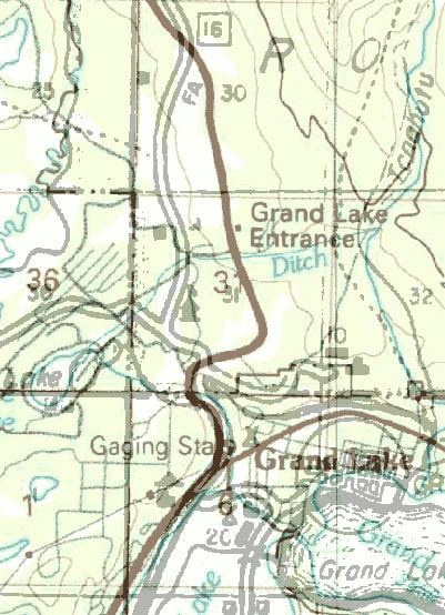
One of the many interesting things about this segment of US 34 is that it essentially follows the valley of the Colorado River between its headwaters in Rocky Mountain National Park and its confluence with the Fraser River in Granby.  Consequently US 34 also provides access to all of the major water collection components of the Colorado-Big Thompson Project.  Those include Grand Lake (Colorado's largest and deepest natural lake) and three artificial impoundments (Shadow Mountain Lake, Lake Granby, and Willow Creek Reservoir).  Since there are many examples of highways which were originally built parallel to rivers, but which later had to be realigned because of water storage projects that were built in those valleys, I set out to explore whether US 34 had any historic alignments that existed prior to the reservoirs in the Middle Park area.
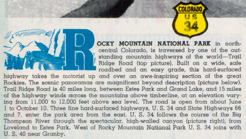
The original road heading west from Estes Park up into the National Park was not Trail Ridge Road (current US 34); it was Fall River Road (which is still open to westbound drivers).  But Fall River was too steep, too narrow, and too curvy to be of much use as a tourist road.  So construction on Trail Ridge began in 1929, and the project was considered complete in 1938.*  In fact, that may have been what prompted CDoT officials to request an extension of the US 34 designation into Colorado.
Although the US route system was implemented in 1926, US 34 was not commissioned in Colorado that early.  Its west end was in Council Bluffs IA until 1934, and after that it went only as far west as Grand Island NE.  It wasn't until 1938 or '39 that US 34 was extended into Colorado, terminating at its junction with US 40 in Granby.  CDoT's 1937 official highway map still showed the road as state highway 16*:
Picture
c. 1937, CDoT
Also note the town of "Stillwater" on that map, between Grand Lake and Granby, and the site of "Monarch" southeast of there (we'll come back to those later). 

I have not seen the '38 CDoT map, but the '39 was probably the first to show that the US 34 designation had been extended into Colorado, coincident with state hwy 16*:
Picture
c. 1939, CDoT
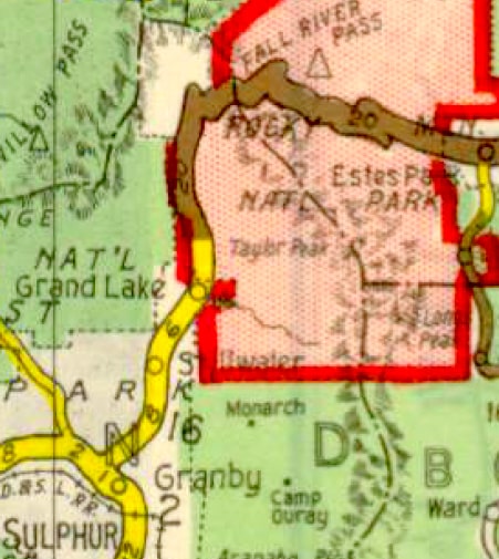
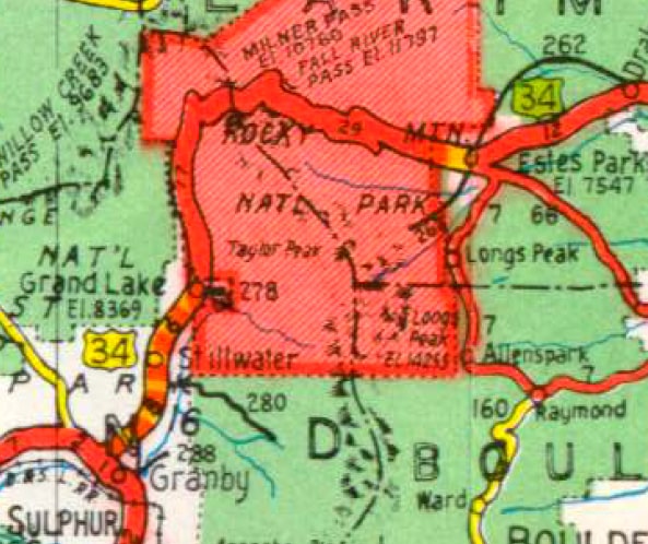
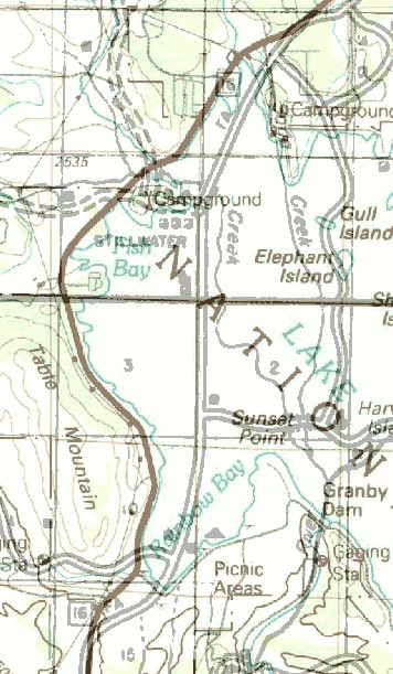
Notice that Grand Lake was the only body of water shown on that map.  Also note the town of Stillwater again, as well as highway 280 heading southeast from there alongside a tributary of the Colorado River, but no label for Monarch (more later).  The backside of that map featured verbiage and photos highlighting things to do and sights to see along five of the east-west US routes in Colorado.  US 34 was included among them, even though it was a brand new route in the state.  Likely the rationale for that was because US 34 provides access to one of the most scenic areas in Colorado, and also the most-visited:
Picture
The following year (1940) there were some changes both to the cartographic style and to the content on the map.  However, since my copy of the 1940 map is not very clear, I am using the 1941 issue to illustrate.  First, note that the town of Stillwater was no longer labeled.  However, hwy. 280 was still there, and the locale of "KaRose" was added to the map.  Also, just to the north of hwy. 280's junction with US 34, notice a more pronounced curve in US 34 (right where Stillwater was labeled on older maps).  It is possible that this was simply the result of improved cartographic accuracy...
Picture
c. 1941, CDoT
...however, by that time it was known that Stillwater was doomed to be submerged beneath the eventual pool of Lake Granby, and 1941 was also the year that construction on Granby Dam began.*  Since it is typically necessary for road relocations to be included among the earliest phases of dam construction projects, the removal of Stillwater's label and the new curve on US 34 were likely related to the fact that construction had begun. 
Regarding the inclusion of either Monarch or KaRose on any of these maps: Monarch ceased to exist in about 1908.  Apparently a couple of its buildings were moved to a summer resort known as KaRose.  One of my sources indicates that entity ceased operations in about 1935, but it is possible the place simply changed ownership, because correspondent Jim Black told me that his parents spent time up there until about 1944.*

That same year (1944) construction commenced on Shadow Mountain Dam.  It was already completed by 1946, prior to Granby Dam (probably because only one impoundment was necessary, whereas Lake Granby required two dikes in addition to its dam).  CDoT's map from the following year (1947) was the first to show Shadow Mountain Lake:
Picture
c. 1947, CDoT
Granby Dam was completed in 1950.  It is unclear whether the two dikes were also completed by that time, but Lake Granby was not shown on CDoT's official highway map until the 1954 issue (it would have taken a lot longer to fill than Shadow Mountain did).  This was also the first issue that no longer showed hwy. 280 or the locale of KaRose.  Most of 280 is submerged; its modern functional equivalent is County Route 6, which runs along the south shore of Lake Granby.  Some information I've seen suggests that KaRose was inundated as well.*
Picture
c. 1954, CDoT
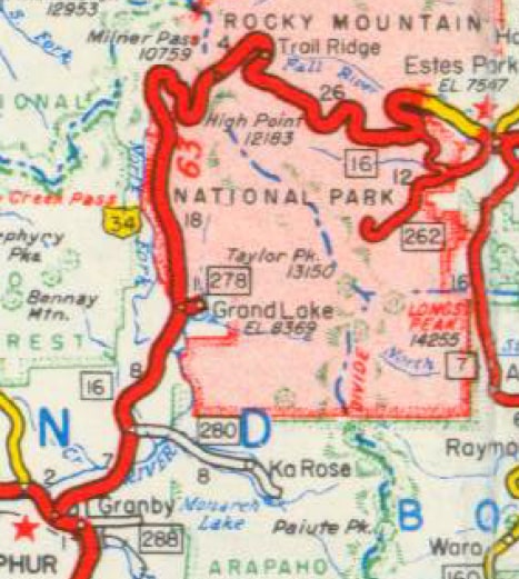
Based on that timeline, US 34 existed in Colorado for about two years before construction began on the Colorado-Big Thompson Project.  So if any realignments were necessary due to the dams, then US 34 would have followed the older alignment(s) for at least two years, maybe a little longer (depending when the new alignments were open to traffic).  But the preceding maps were not detailed enough to determine whether any realignments were necessary. 
So in order to analyze that, I found a more detailed highway map of Grand County.  The basemap was produced in 1936, but it came to be available online because it was used for the 1940 census.  In other words, this map was created a few years before US 34 was extended into Colorado.  So the road was labeled SH 16, but it is reasonable to assume that it was still the same road a couple years later when the US 34 designation was applied to it.  I overlaid this 1936 map on a modern basemap that shows the current alignment of US 34.  Due to cartographic inaccuracies on the 1936 map, the two maps did not register perfectly, but nevertheless I was able to locate a few areas where the original alignment of US 34 deviated from the current alignment.  In the images that follow, the modern alignment of US 34 is shown in a deep red color, and you will see some areas where the original road (shown with black casing) followed a different alignment.  The most significant realignment occurred around the former locale of Stillwater, which (as mentioned previously) was submerged.  The original highway followed more of a straight shot through the settlement, whereas the dam necessitated a realignment which curves around the west shoreline of Lake Granby:
Picture
The southernmost segment of the older alignment is not submerged, but neither is it plainly visible on modern aerial photos.  The northernmost portion also remained on dry land, and a short segment of it is still open to traffic (now designated CR 652).  This interactive image is looking southwest on US 34.  The modern alignment curves to the right, but the gravel road to the left is the original alignment:
Along the top of the map above, there is a square label for SH 16.  For reference on this next map, that same SH 16 marker is visible at lower left.  To the north of the marker, there appear to be some variations in alignment.  I attribute most of that to cartographic inaccuracies on the 1936 map, but I am also quite certain that today's CR 46 (which forms a small loop off modern US 34) was the original alignment of US 34.  This map also suggests that US 34 had to be relocated slightly to the west of the Shadow Mountain shoreline, but I am uncertain whether any of the current shoreline roads originally carried US 34 traffic:
Picture
This view is looking north on US 34.  Again, the modern alignment curves to the right, but it seems likely that the original alignment was along CR 46 (the gravel road to the left):
The "Gaging Sta" label at the top of the preceding map is the same one visible at the bottom of this next map (just west of Grand Lake).  To the north is a fairly notable divergence, although this one was not related to the water storage projects.  In the area of RMNP's entrance station and Kawuneeche Visitor Center, the original road was to the west of the current road.  Based on the 1958 USGS topo, I believe the southernmost portion of this historic alignment is still traceable (partly as a public road, partly non-public, partly trail).  However, aerial photos do not clearly show how the old road continued to the north to connect with the current highway:
Picture
The final area that showed an older alignment was back to the south, almost to Granby.  This one also does not appear to be a result of the reservoirs.  US 34 originally followed what is now CR 620, crossing the Colorado River just upstream from the current US 34 bridge.  CR 620's current bridge is a replacement; the original SH 16/US 34 bridge is no longer there.  North of the bridge, I am uncertain of the route that the original highway followed, whether it partially followed existing roads, or whether the original alignment was vacated:
Picture
This image is looking north on US 34.  The current alignment curves to the left, but originally US 34 followed the gravel road to the right (now CR 620):
To summarize so far: as it turns out, there are indeed some historic segments of US 34 in the Middle Park area.  Nothing particularly fun to drive, but at least my curiosity is satisfied.

Highways were not the only things that changed as a result of the water storage projects in the upper Colorado River valley.  Even the names of some streams were changed... or at least that is when some of the name changes were recognized.

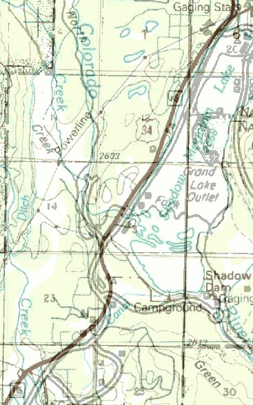
First, a little background: the portion of today's Colorado River within the state of Colorado was not always so named.  From about 1870 until 1921, that stream was known to white settlers as the Grand River.*  Grand Lake (the body of water) was named as such by white explorers because it was considered the source of the Grand River.  The North Fork of the Grand River flowed into the main Grand where the south end of Shadow Mountain Lake is now.  There was also a South Fork of the Grand River, which flowed into the main Grand near where Deer Island is now (in Lake Granby).  There was even a Roaring Fork of the Grand; some of that was illustrated on this 1915 map:
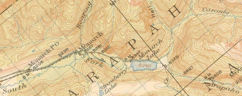
Picture
c. 1915, USGS
There you can see two streams flowed into Monarch Lake from the east: the South Fork and Arapaho Creek.  Flowing out of Monarch Lake to the west was the South Fork.  At the town of Monarch, the Roaring Fork joined the South Fork.

In 1921 the Grand River in its entirety (from its headwaters in Colorado to its confluence with the Green River in Utah) was renamed as the Colorado River.*  So at that time one would think that the North Fork, South Fork, and Roaring Fork all became forks of the Colorado (rather than forks of the Grand).  However, based on what I find in the GNIS database, it was a bit more complicated than that.  The North Fork Grand did indeed become the North Fork Colorado, but apparently there was some discrepancy about the correct name of the South Fork: some maps referred to it as the East Fork.  Rather than trying to decide between those two, the decision was made to change the name of the stream that flows out of Monarch Lake to Arapaho Creek (same as one of the streams that flows in).  So what was done with the portion of the South Fork that flows into Monarch?  That was renamed to Buchanan Creek.  And that leaves one more question: what was the Roaring Fork then considered to be a fork of?  Remarkably, it officially became Roaring Fork of Arapaho Creek.

So those are the decisions that were made on paper in 1921.  But those changes took awhile to catch on with the general populace.  In particular, some maps into the 1940s continued to refer to Arapaho Creek by its old name, South Fork.  I believe it was the construction of Lake Granby and its attendant changes (new recreation area, new campgrounds, new roads and trails, etc.) that finally pushed the new toponyms more to the forefront of public consciousness.  For instance, the arm of Lake Granby that extends way off to the east was named "Arapahoe Bay" (as opposed to "South Fork Bay").  By the 1950s, most maps had been updated to show Buchanan Creek flowing into Monarch Lake, and Arapaho Creek flowing out:
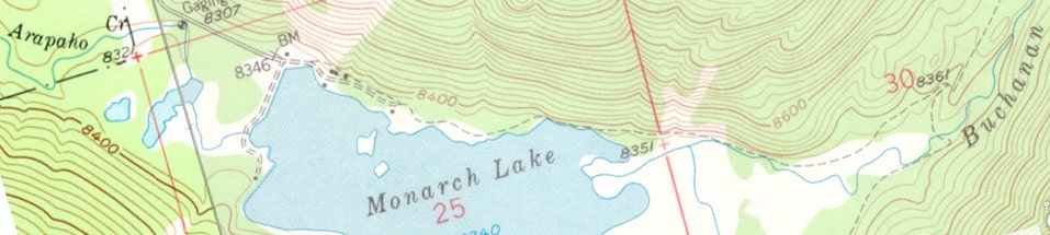
Picture
c. 1958, USGS
I find it even more remarkable that the toponym "Roaring Fork of Arapaho Creek" wasn't changed after Lake Granby was formed, considering the fact that it no longer even flows into Arapaho Creek (it flows directly into Arapaho Bay of Lake Granby). 

Why spend all of this time on names of streams, anyway?  Personally, it was eye-opening when I learned that the Colorado River used to have a South Fork, and when I consider the facts that a.) it is almost completely submerged, and b.) the old name is fading from collective memory, those are both things that I view with a sense of loss.

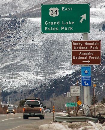
To wrap it up by getting back to highways: another topic that interests me about this segment of US 34 is its signposted direction.  US 34 is ultimately an east-west route, and it is signed east-west in Colorado.  But (as I mentioned at the beginning) the "westernmost" 27 miles of US 34 are actually oriented strongly north-south.  I realize there are many examples of this type of thing, particularly in places like Colorado that have challenging topography.  And I understand that generally it is preferable to sign routes with their ultimate cardinal directions, including any segments that may run counter to those directions.  However, exceptions can be made in states that contain the highway's terminus, and exceptions are made in other states. 
There are several examples of this, but just to name one: US 24 is signed east-west between Colorado and Ohio, but at the Michigan line it changes to north-south.  In that particular case it is appropriate, because US 24 does run north-south in Michigan, and it terminates in Michigan before ever resuming an east-west bearing.  I think CDoT should take a cue from states like Michigan, because it would make a lot of sense to sign US 285 as east-west between Denver and Kenosha Pass, and US 24 as north-south between Minturn and Buena Vista.
Get your copy of this epic book that commemorates the first century of the US route system!

Now, should we make the same argument about US 34 between Granby and RMNP?  After all, which way does one go to get from Granby to the Park?  It's definitely north, not east.  Or think of it this way: people heading from Denver to Grand Lake use westbound US 40.  Then they make a right turn at Granby to head north, but the signs say they're heading... east?
Picture
Sanderson, Dec. 2017
Seems kind of silly, doesn't it?  Would it make more sense to sign US 34 as "north" from Granby to the Park?  Actually, I'm not convinced that changing US 34's signed direction would be a great idea.  There are some important particulars to consider in this situation.  Keep in mind, US 34 through RMNP is open only about five months out of the year. 
Picture
Sanderson, Dec. 2006
During those summer months it handles heavy tourist traffic.  Visitors to the area may not have a good mental map of Colorado, but they may still have a conceptual awareness that the Rocky Mountains run north-south, and that US 34 runs east-west across the mountains.  So when they're in the Middle Park area, and they want to cross the mountains and get back to the Front Range, they are probably aware that they need to head "east".  But if instead they were to be presented with a choice of "north" or "south" on US 34, that might cause confusion.

*Sources and further reading:
  • More about the current and historic endpoints of US 34
  • Wikipedia article on Trail Ridge Road
  • US Bureau of Reclamation information about Colorado-Big Thompson Project
  • Grand Lake Area Historical Society article about Monarch and KaRose
  • ibid, info about Stillwater
  • University of Colorado Libraries info about KaRose
  • Wikipedia article on the Colorado River
  • The state highway 16 designation was purged in 1968, then recycled in 1971, when it was applied to the current route in Fountain.  More on the mesalek.com archive
.
2 Comments
Jim Black link
8/4/2021 09:10:08 pm

During World War II, my father was stationed at Lowry Air Base. He met my mother in Denver and they were married on June 21, 1943. Both of my parents talked about driving my uncles, Buick up to the KaRose resort and spending a week there. My dad talked about rowing a boat back and forth on the lake, fishing while my mother rode with him. Both of my parents are gone now, but that is a story they both shared with me. My dad and I walked Monarch Lake and fished from the shore as well as the headwaters of Monarch lake in the late 1950's and through the 1960's. Based on what my parents passed on to me, I think KaRose was still in operation until late 1944.

Reply
Dale Sanderson link
8/5/2021 06:11:49 am

Thanks for passing that along; I have updated the page accordingly.

Reply

Your comment will be posted after it is approved.


Leave a Reply.

    RSS Feed

    Author

    This guy.

    Categories

    All
    Alabama
    Arizona
    Boston
    California
    Colorado
    Denver
    Florida
    Geo-center
    Geography
    Historic
    Idaho
    Illinois
    Indiana
    Kansas
    Kentucky
    Maryland
    Massachusetts
    Michigan
    Midpoint
    Mileage
    Minnesota
    Missouri
    Nebraska
    New Hampshire
    New Jersey
    New Mexico
    Newport
    New York
    North Carolina
    North Dakota
    Numbering
    Oddity
    Ohio
    Oklahoma
    Oregon
    Pennsylvania
    Proposed
    Renumbering
    Signage
    South Carolina
    South Dakota
    Tennessee
    Texas
    Updates
    US 101
    US 127
    US 13
    US 136
    US 150
    US 154
    US 16
    US 160
    US 163
    US 164
    US 169
    US 177
    US 180
    US 183
    US 190
    US 191
    US 20
    US 210
    US 212
    US 218
    US 220
    US 23
    US 231
    US 24
    US 241
    US 25
    US 259
    US 26
    US 266
    US 27
    US 270
    US 271
    US 277
    US 281
    US 283
    US 285
    US 287
    US 3
    US 31
    US 311
    US 321
    US 331
    US 34
    US 36
    US 360
    US 371
    US 377
    US 383
    US 385
    US 40
    US 400
    US 411
    US 431
    US 450
    US 46
    US 48
    US 491
    US 50
    US 530
    US 55
    US 59
    US 6
    US 60
    US 61
    US 62
    US 63
    US 65
    US 66
    US 666
    US 67
    US 730
    US 74
    US 77
    US 80
    US 81
    US 83
    US 84
    US 85
    US 87
    US 89
    US 93
    US 94
    US 96
    US 99
    Utah
    Virginia
    Washington
    Watersheds
    West Virginia
    Wyoming

    Archives

    April 2025
    July 2024
    August 2023
    May 2023
    March 2023
    February 2023
    January 2023
    August 2022
    March 2022
    February 2022
    January 2022
    August 2021
    July 2021
    June 2021
    April 2021
    February 2021
    January 2021
    August 2020
    July 2020
    May 2020
    April 2020
    March 2020
    February 2020
    January 2020
    December 2019
    October 2019
    September 2019
    August 2019
    May 2019
    January 2019
    November 2018
    June 2018
    April 2018
    March 2018
    November 2017
    September 2017
    August 2017
    June 2017
    March 2017
    February 2017
    January 2017
    December 2016

Copyright © 1998-2025
Picture