US Ends .com
  • Home
  • Store
    • US highway book
    • US highway map
    • Florida US highway map
  • Endpoints
    • US 1 - US 9 >
      • 1 >
        • 201
        • 301
        • 401 [i]
        • 401 [ii]
        • 401
        • 501
        • 601
        • 701
      • 2w >
        • 102
      • 2e >
        • 202
        • 302
      • 3
      • 4 >
        • 104
      • 5
      • 6 >
        • 106
        • 206
      • 7
      • 8
      • 9 >
        • 109*
        • 209
        • 309
    • US 10 - US 19 >
      • 10 >
        • 110
        • 210
        • 310
        • 410
      • 11 >
        • 111
        • 211
        • 311
        • 411 [i]
        • 411 [ii]
        • 411
        • 511*
        • 611
        • 711*
      • 12 >
        • 112
        • 212
        • 312
      • 13 >
        • 113
        • 213
      • 14
      • 15
      • 16 >
        • 116
        • 216
      • 17 >
        • 17-1
        • 117 [i]
        • 117
        • 217
      • 18 >
        • 118
        • 218
      • 19 >
        • 119
        • 219
        • 319
    • US 20 - US 29 >
      • 20e >
        • 120
        • 220
        • 320
        • 420
      • 20w
      • 21 >
        • 121 [i]
        • 121
        • 221
        • 321
        • 421
        • 521
      • 22 >
        • 122 [i]
        • 122 [ii]
        • 222
        • 322
        • 422e
        • 422w
        • 522
        • 622*
      • 23 >
        • 123 [i]
        • 123
        • 223
      • 24 >
        • 124
        • 224
      • 25
      • 26 >
        • 126
      • 27 >
        • 127
        • 227
      • 28
      • 29 >
        • 129
    • US 30 - US 39 >
      • 30 >
        • 130
        • 230
        • 330
        • 430
        • 530
        • 630*
        • 730
        • 830
      • 31 >
        • 131
        • 231
        • 331 [i]
        • 331
        • 431
      • 32
      • 33
      • 34
      • 35
      • 36 >
        • 136
      • 38 >
        • 138
    • US 40 - US 49 >
      • 40 >
        • 140
        • 240
        • 340
      • 41 >
        • 141
        • 241 [i]
        • 241 [ii]
        • 341
        • 441 >
          • 441n
          • 441s
        • 541
        • 641
      • 42
      • 43
      • 44
      • 45
      • 46
      • 48 [i]
      • 48 [ii]
      • 48
      • 49
    • US 50 - US 59 >
      • 50 >
        • 150
        • 250
        • 350
        • 450
        • 550
        • 650
      • 51 - 55 >
        • 51 >
          • 151
        • 52 >
          • 152
        • 53
        • 54 >
          • 154
        • 55
      • 56 >
        • 156
      • 57
      • 58 >
        • 158
        • 258
      • 59 >
        • 159
        • 259
    • US 60 - US 69 >
      • 60 >
        • 160
        • 260
        • 360
        • 460
      • 61 - 65 >
        • 61 >
          • 161
        • 62
        • 63 >
          • 163 [i]
        • 64 >
          • 164 [i]
          • 164 [ii]
          • 264
        • 65 >
          • 165
      • 66 >
        • 166
        • 266
        • 366 [i]
        • 366 [ii]
        • 466 [i]*
        • 466 [ii]
        • 566
        • 666
      • 67 >
        • 167
      • 68 >
        • 168
      • 69 >
        • 169
    • US 70 - US 79 >
      • 70 >
        • 170
        • 270 [i]*
        • 270
        • 370
        • 470
      • 71 >
        • 171
        • 271
        • 371 [i]
        • 371 [ii]
        • 371
      • 72 - 76 >
        • 72
        • 73
        • 74
        • 75 >
          • 175
          • 275
        • 76 >
          • 176
          • 276
      • 77 >
        • 177
        • 277
        • 377
      • 78 >
        • 178
        • 278
        • 378
      • 79
    • US 80 - US 89 >
      • 80 - 84 >
        • 80 >
          • 180 [i]
          • 180
          • 280
          • 380
        • 81 >
          • 181
          • 281
        • 82
        • 83 >
          • 183
          • 283
          • 383
        • 84
      • 85 - 89 >
        • 85 >
          • 185
          • 285 [i]
          • 285
          • 385 [i]
          • 385
          • 485
        • 87 >
          • 187
          • 287n
          • 287s
        • 89n
        • 89s >
          • 189 [i]
          • 189
    • US 90 - US 99 >
      • 90 - 94 >
        • 90 >
          • 190
          • 290
        • 91 >
          • 191 >
            • 191n
            • 191s
          • 491
        • 92 >
          • 192
        • 93
        • 94
      • 95 -98 >
        • 95 >
          • 195
          • 295
          • 395
        • 96 [i]
        • 96
        • 97 >
          • 197
        • 98
      • 99 >
        • 199
        • 299
        • 399
    • Anomalies >
      • 101
      • 163
      • 400
      • 412
      • 425
  • Places
    • A-L >
      • A >
        • Aberdeen
        • Albuquerque
        • Amarillo
        • Apalachicola
        • Astoria
        • Atlantic
      • B >
        • Baltimore
        • Baton Rouge
        • Bay Area
        • Bishop
        • Boone
        • Brady
        • Bristol
        • Brownsville
        • Brunswick
      • C >
        • Charleston
        • Chattanooga
        • Chicago
        • Cincinnati
        • Cleveland
        • Cody
        • Corpus
        • Cortez
        • Council Bluffs
        • Covington
        • Crescent
        • Cumberland Gap
      • D-E >
        • Dallas
        • Des Moines
        • Detroit
        • Dothan
        • Douglas
        • El Paso
        • Erie
        • Eugene
      • F >
        • Farmington
        • Flagstaff
        • Florence
        • Fox Valley
        • Franklin
      • G >
        • Gallup
        • Georgetown
        • Grand Junction
        • Grand Portage
        • Grayling
        • Great Falls
        • Greeley
      • H-I >
        • Hardeeville
        • Harrisburg
        • Holbrook
        • Idaho Falls
        • Int'l Falls
      • J-K >
        • Jacksonville
        • Joplin
        • Junction
        • Kansas City
        • Keokuk
        • Key West
        • Kingman
      • L >
        • Laredo
        • Lewiston
        • Long Beach
        • Los Angeles
        • Louisville
        • Lubbock
    • M-R >
      • M >
        • Mackinaw
        • Madison
        • Maryhill
        • Maysville
        • Miami
        • Midway
        • Miles City
        • Milford
        • Milwaukee
        • Minneapolis
        • Mobile 31
        • Mobile 31-43-45
        • Montgomery
        • Monticello
        • Mount Vernon
      • N-O >
        • Nags Head
        • Naples
        • Natchez
        • New Castle
        • New Orleans
        • Niagara
        • Norlina
        • Ocean City
        • Oklahoma City
      • P >
        • Pee Dee
        • Pembina
        • Pensacola
        • Petersburg
        • Philadelphia
        • Piegan
        • Pineville
        • Port Arthur
        • Portsmouth
      • Q-R >
        • Quad Cities
        • Rapid City
        • Raton
        • Reading
        • Richmond
        • Rockingham
        • Rouses Point
    • S-Z >
      • S >
        • San Antonio
        • San Antonio NM
        • San Diego
        • Santa Fe
        • Savannah
        • Sioux
        • Springer
        • Springfield
        • St. Ignace
        • St. John
        • St. Paul
        • St. Pete
      • T-U-V >
        • Tallahassee
        • Tampa
        • Toledo
        • Trinidad
        • Tuba City
        • Ucolo
        • VA Beach
      • W >
        • Walterboro
        • Waverly
        • West Memphis
        • Wilmington
        • Wilson
        • Wrightsville
      • Y >
        • Yellowstone E
        • Yellowstone N
        • Yellowstone NE
        • Yellowstone S
        • Yellowstone W
  • Highways
    • Map of all endpoints
    • Sources
    • History
    • 1926 almost-routes
    • Intra-state routes
    • Numbering
    • Colors
    • Gaps
    • Blog
  • Bonus
    • Colorado >
      • Lowest point
      • Antipodes
      • Toponymy >
        • Roots
      • Colloquialisms
      • Populations
      • Denvers
    • Washington Meridian
    • Watersheds >
      • Headwaters Hill
      • Three Waters Mtn.
      • Parting of the Waters
    • Geo-centers >
      • 48 states
      • 50 states
      • North America
    • State corners >
      • AZ-CO-NM-UT
      • CO-UT-WY
      • CO-NE-WY
      • CO northeast
      • CO-KS-NE
      • CO-KS-OK
      • CO-NM-OK
      • NM-OK-TX
      • NM southeast
      • TX northwest
  • Connect
    • Author/history
    • Rationale
    • Contact
    • Contributors
    • Submissions

US Highways Blog

A history of US route 83 and family

5/20/2020

0 Comments

 
From humble beginnings to great lengths
(last updated 11/27/2023)
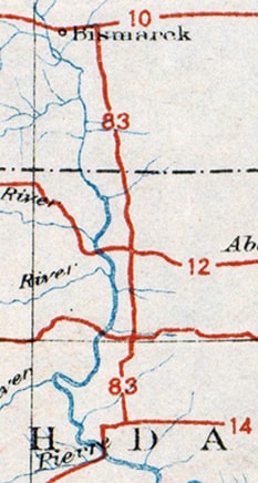
In 1925, when the US highway system was envisioned, there were plenty of proposed east-west routes crossing the Great Plains states, but there was a conspicuous lack of north-south routes between US 81 and US 85.  This gap was about 300 miles wide in North Dakota, and it only increased to the south, until the gap was more like 500 miles wide in Texas.  Obviously this was not an ideal situation for those six states, but a big obstacle prevented an easy remedy: there were very few decent-quality, long-distance, north-south roads through the Plains.  One exception was the road between the capital cities of the two Dakotas.  Those states petitioned AASHO for the US 83 designation, and by the time the US route system was officially inaugurated in 1926, their wish had been granted.  For the next couple years, US 83 was a very short route -- only about 170 miles long -- running between Bismarck ND and Pierre SD:
Picture
c. 1926, AASHO
Picture
c. 1928, Gallup
However, by the early 1930s the US 83 designation had been extended not only north to the Canada border, but all the way down to the Mexico border too.  This increased US 83's distance to nearly 1900 miles, and made it one of the longest north-south US routes.  Additionally, as a result of US 83's new role as a trunk route, three newer US routes were numbered as branches of US 83.  Two of these soon became quite lengthy themselves, and they still exist (US 183 and US 283).  Just as these highways intertwine with each other, their history is also interrelated.  This article examines the evolution of US 83, as well as the x83 routes that are part of its "family".
Note that this post does not elaborate on the specific endpoints of each route, because that information has already been covered elsewhere: photos, maps, and more history can be viewed at the following links:
US 83
US 183
US 283
US 383

Let me start by qualifying the statement that US 83, 183, and 283 all became long routes in the '30s.  They were somewhat unusual in the sense that they were each commissioned before they were entirely constructed and/or improved to the standards considered necessary for a US route.  AASHO did this with the understanding that future highway development would eventually result in roads that were continuous between their endpoints.  But there were timeframes during which these routes existed in separate, disconnected segments.  In 1929 no portion of US 83 existed in Nebraska, yet AASHO allowed Kansas to begin signposting its portion of US 83.  (Reportedly this was only under the condition that improvements to the road's surface would be made.  But it is unclear exactly what the term "improvements" entailed, or whether there was a specific timeframe: even by 1932, the Kansas official state highway map was still indicating that only a very small percentage of US 83 was hard-surfaced in the state.  The majority was gravel, and some segments were still just dirt.  Long-distance travel across the Great Plains during the 1930s was not for the faint of heart.)  
Picture
Get your very own map showing all current and historic US routes!

It was the following year (1930) that the US 83 designation was extended to both border crossings, as shown on these clips from a 1931 Clason atlas:
Picture
Picture
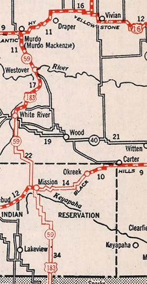
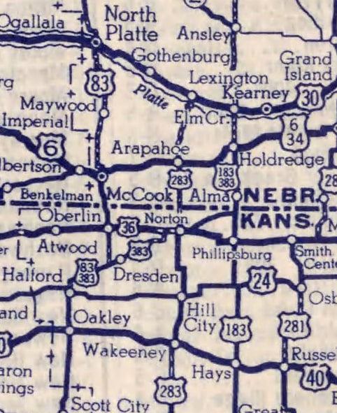
At this point it should be noted that the original routing for US 83 was significantly different from today's route through portions of South Dakota, Nebraska, and Kansas.  Modern US 83 heads west from Vivian SD and then south from Murdo.  But originally US 83 went east from Vivian, and then south from Presho, roughly following the path of what is now US 183 through Nebraska.  But this 1931 atlas showed no part of US 83 in Nebraska -- in other words there was a lengthy gap between Presho and the Kansas state line.  At the time, this gap could be traversed by using SD state highway 53 and NE state highways 10 and 22.  Most of that route was shown as "all-weather", so what was lacking that prevented it from being signposted as US 83?  The answer is: Nebraska was not satisfied with AASHO's decisions.

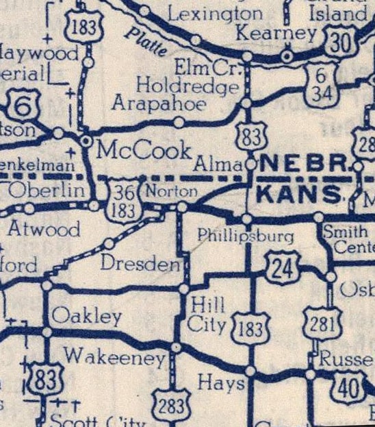
Kansas was primarily interested in developing today's US 183 corridor, running through Phillipsburg, Hays, and Kinsley.  But Nebraska instead preferred to emphasize today's US 83 corridor, i.e. McCook, North Platte, and Valentine.  At the state line those two corridors were offset by about 65 miles, so it was not really possible to unify them under a single routing.  Nebraska's preferred solution was to have US 83 split into an east branch and a west branch, with US 83W running through McCook and North Platte, and US 83E running through Alma and Holdrege.  However, this brought up another obstacle: the road between North Platte and Valentine was not even a part of Nebraska's state highway system.  It was in poor condition, and some segments had not been built at all.  There was no way AASHO could bestow a US highway designation on that particular segment through Nebraska.  Furthermore, AASHO was no longer commissioning new split routes (due to the confusion caused by split routes that already existed elsewhere in the country).  So in 1929, when the Great Plains states asked AASHO to extend US 83 south from Pierre, AASHO chose to do it via the only practical route, which at the time was essentially what is now the US 183 corridor heading south from Presho SD.  Since this arrangement was not what Nebraska asked for, they refused to signpost US 83 in their state.  In 1931 they again petitioned AASHO to authorize a US 83E and 83W through their state, but AASHO refused.

Upon reaching the NE-KS border, the route of US 83 did something interesting in order to reach its temporary southern terminus in Liberal KS:
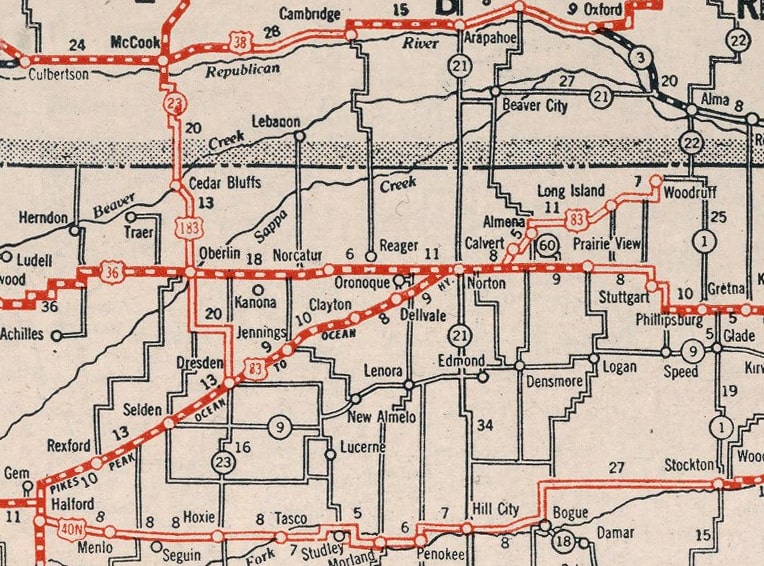
Picture
c. 1931, Clason
Initially US 83 did not follow the same routing it does today (i.e. heading north from Selden and passing through Oberlin on its way to McCook).  Rather, traffic was directed to remain on the diagonal route through Norton and all the way to the Nebraska line near Alma. Nebraska's desire for a split route in US 83 was addressed in 1930 with the creation of US 183, which was to serve Oberlin, McCook, and North Platte.  Like several other three-digit US routes minted during the 1930s, US 183 was envisioned as an alternate route for US 83, closing the loop at Vivian on the north and Dresden on the south.  The same 1931 atlas already showed US 183 in South Dakota:
Picture
c. 1931, Clason
However, initially US 183 was continuous only between Dresden and North Platte, so it was only about 116 miles long.  North of there, maps show two roads traversing the Sand Hills to Valentine: one through Tryon and Mullen, and the other through Stapleton and Thedford.  For the next several years, neither of those roads were improved enough to be considered "highways".  Nebraska's official state highway maps through at least 1940 classified those roads as "designated but not maintained".  So I conclude that US 183 was never a continuous route between its original termini (Vivian and Dresden).

US 283 was designated in 1932.  It was commissioned to run from US 83 in Norton KS south to Brownwood TX.  But like the older members of its route family, it was not initially signposted along the entire distance between those endpoints.  Rather, the 1933 Kansas official showed US 283 only up to Dodge City.  North of there to Norton, the route was marked as state highway 21 (so initially US 283 did not connect with any of its implied route family).  In 1935 US 283 was improved enough that signage was added between Dodge and Ness City.  Then in 1939, US 283 was finally signposted the rest of the way up to US 83 at Norton.  Not only that, but US 283 was also extended far to the south, all the way to Junction TX, thus attaining its maximum historical length of 804.1 miles:
Picture
c. 1940, TXDoT
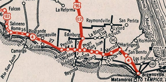
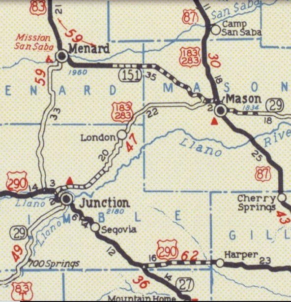
As that map illustrates: that same year US 183 was also extended to the same town, where the two routes shared a common terminus and were reunited with their "parent" route (US 83).  Texas did this at AASHO's request, because at the time AASHO still considered it to be important that an x83 route should connect with mainline 83 on at least one end, if not on both ends.  But the arrangement was different than today: instead of diverging south of Throckmorton, both 183 and 283 were twinned down to Albany.  South of there US 183 traffic was directed along the corridor currently occupied by US 283 (Baird, Coleman, Brady).  US 283 on the other hand followed today's TX 6 to Cisco, then today's US 183 through Rising Star, Brownwood, and Brady.  From there the two routes were twinned again, through Mason to Junction.
Now, back to Kansas, and backtracking a bit to 1937, the southernmost segment of US 183 was changed slightly.  Instead of jogging south and east to Dresden, US 183 was redirected essentially due south from Oberlin, such that it ended near Selden.  But that was a short-lived arrangement, because in 1939 US 183 was extended much further south: through the remainder of Kansas, all of Oklahoma, and deep into Texas (as mentioned above).  In order to accomplish that, US 183 made a 66-mile long jog east from Oberlin along US 36 to Phillipsburg before turning south again.  That set up a ridiculous arrangement where travelers heading north or south on either US 83 or US 183 would each have to make a significant lateral jog, crossing each other through Norton before resuming their north or south bearing:
Picture
c. 1940, Rand McNally
Clearly that situation needed to be addressed, and change was not long in coming: in 1941 the US 83 and US 183 designations were swapped in northern Kansas, through all of Nebraska, and up to Vivian SD.  Once that had been done, the arrangement surrounding Norton made a lot more sense: now US 83 and US 183 both followed corridors that were essentially due north-south, without having to make significant lateral jogs.  However, that solution introduced a new (albeit minor) problem: the diagonal route through Norton (formerly US 83) was now without a US route designation.  A new designation was really necessary only along the 74-mile stretch between Selden and the Nebraska state line.  But interests in Kansas thought US 383 would seem like a more important road if it connected with US 30, so they convinced Nebraska to ask AASHO to extend the route across the state line, overlapping it with US 183, and thus the new US 383 designation was born:
Picture
c. 1944, Rand McNally
One minor difference between the old US 83 routing and the new US 183 routing was: whereas US 83 actually jogged to serve the city of Kearney NE, US 183 never did, instead using a straight shot between Ansley and Elm Creek:
Picture
c. 1940, Rand McNally
Picture
c. 1944, Rand McNally
An additional change took place in 1941: the US 283 designation was extended up to its current terminus in Lexington NE.  And speaking of Nebraska: remarkably, this 1949 map shows that a connection between North Platte and Valentine had still not been established:
Picture
c. 1949, Gousha
A 1951 letter from Nebraska to AASHO indicated that they expected the final segment of US 83 between North Platte and Valentine to be completed in 1952 (and that appears to be confirmed on the 1955 issue of their state map).  Nebraska also asked AASHO to define US 83 as running through Stapleton, instead of through Mullen and Tryon -- a route Nebraska themselves described as "merely sand hill trails".  Yet Nebraska had been trying to get those trails through the Sand Hills approved as a US highway for the preceding 25 years!  So, despite original plans and signposting shown on several maps, neither US 183 nor US 83 were ever complete along the corridor through Mullen and Tryon.

Back to Texas: right around that same time, in 1952, the US 377 designation was extended southwest to Brownwood, and then along US 183 to Brady.  From there, US 377 continued along US 183-283 through Mason to Junction (and beyond).  So rather than keeping two pointless overlaps with US 377, the US 283 designation was cut back to its current terminus at Brady, reducing its total length to 720.4 miles.
As for the US 183 designation: it was completely repurposed south of Brownwood by following its current corridor through Austin and down to Refugio.  Since then, US 183 measures 1244 miles.

​When US 183 and 283 were removed from the town of Junction, they lost their sole remaining physical junction with US 83 (although they still connect to each other, as they are overlapped between Vernon and Throckmorton).  Ever since that change was implemented in 1952, the corridors for each of these routes have remained essentially the same (except for minor intra-city routings).  


​The only remaining change involved US 383.  Because the Nebraska segment of that route was entirely overlapped with US 183, NDoR had it truncated to the Kansas state line in 1960.  Then in 1979 AASHTO approved KDoT's request to decommission the remainder of US 383.  But its memory is preserved in the number of its replacement designation, K-383.
I find it interesting and remarkable that US 83 started out as a single short route of 170 miles, but it quickly grew to a 1900-mile-long border-to-border route, and also spawned two branch routes that added another 2000 miles to the family.
Get your copy of this epic book that commemorates the first century of the US route system!
0 Comments

Your comment will be posted after it is approved.


Leave a Reply.

    RSS Feed

    Author

    This guy.

    Categories

    All
    Alabama
    Arizona
    Boston
    California
    Colorado
    Denver
    Florida
    Geo-center
    Geography
    Historic
    Idaho
    Illinois
    Indiana
    Kansas
    Kentucky
    Maryland
    Massachusetts
    Michigan
    Midpoint
    Mileage
    Minnesota
    Missouri
    Nebraska
    New Hampshire
    New Jersey
    New Mexico
    Newport
    New York
    North Carolina
    North Dakota
    Numbering
    Oddity
    Ohio
    Oklahoma
    Oregon
    Pennsylvania
    Proposed
    Renumbering
    Signage
    South Carolina
    South Dakota
    Tennessee
    Texas
    Updates
    US 101
    US 127
    US 13
    US 136
    US 150
    US 154
    US 16
    US 160
    US 163
    US 164
    US 169
    US 177
    US 180
    US 183
    US 190
    US 191
    US 20
    US 210
    US 212
    US 218
    US 220
    US 23
    US 231
    US 24
    US 241
    US 25
    US 259
    US 26
    US 266
    US 27
    US 270
    US 271
    US 277
    US 281
    US 283
    US 285
    US 287
    US 3
    US 31
    US 311
    US 321
    US 331
    US 34
    US 36
    US 360
    US 371
    US 377
    US 383
    US 385
    US 40
    US 400
    US 411
    US 431
    US 450
    US 46
    US 48
    US 491
    US 50
    US 530
    US 55
    US 59
    US 6
    US 60
    US 61
    US 62
    US 63
    US 65
    US 66
    US 666
    US 67
    US 730
    US 74
    US 77
    US 80
    US 81
    US 83
    US 84
    US 85
    US 87
    US 89
    US 93
    US 94
    US 96
    US 99
    Utah
    Virginia
    Washington
    Watersheds
    West Virginia
    Wyoming

    Archives

    April 2025
    July 2024
    August 2023
    May 2023
    March 2023
    February 2023
    January 2023
    August 2022
    March 2022
    February 2022
    January 2022
    August 2021
    July 2021
    June 2021
    April 2021
    February 2021
    January 2021
    August 2020
    July 2020
    May 2020
    April 2020
    March 2020
    February 2020
    January 2020
    December 2019
    October 2019
    September 2019
    August 2019
    May 2019
    January 2019
    November 2018
    June 2018
    April 2018
    March 2018
    November 2017
    September 2017
    August 2017
    June 2017
    March 2017
    February 2017
    January 2017
    December 2016

Copyright © 1998-2025
Picture