US Ends .com
  • Home
  • Store
    • US highway map
    • Florida US highway map
  • Endpoints
    • US 1 - US 9 >
      • 1 >
        • 201
        • 301
        • 401 [i]
        • 401 [ii]
        • 401
        • 501
        • 601
        • 701
      • 2w >
        • 102
      • 2e >
        • 202
        • 302
      • 3
      • 4 >
        • 104
      • 5
      • 6 >
        • 106
        • 206
      • 7
      • 8
      • 9 >
        • 109*
        • 209
        • 309
    • US 10 - US 19 >
      • 10 >
        • 110
        • 210
        • 310
        • 410
      • 11 >
        • 111
        • 211
        • 311
        • 411 [i]
        • 411 [ii]
        • 411
        • 511*
        • 611
        • 711*
      • 12 >
        • 112
        • 212
        • 312
      • 13 >
        • 113
        • 213
      • 14
      • 15
      • 16 >
        • 116
        • 216
      • 17 >
        • 17-1
        • 117 [i]
        • 117
        • 217
      • 18 >
        • 118
        • 218
      • 19 >
        • 119
        • 219
        • 319
    • US 20 - US 29 >
      • 20e >
        • 120
        • 220
        • 320
        • 420
      • 20w
      • 21 >
        • 121 [i]
        • 121
        • 221
        • 321
        • 421
        • 521
      • 22 >
        • 122 [i]
        • 122 [ii]
        • 222
        • 322
        • 422e
        • 422w
        • 522
        • 622*
      • 23 >
        • 123 [i]
        • 123
        • 223
      • 24 >
        • 124
        • 224
      • 25
      • 26 >
        • 126
      • 27 >
        • 127
        • 227
      • 28
      • 29 >
        • 129
    • US 30 - US 39 >
      • 30 >
        • 130
        • 230
        • 330
        • 430
        • 530
        • 630*
        • 730
        • 830
      • 31 >
        • 131
        • 231
        • 331 [i]
        • 331
        • 431
      • 32
      • 33
      • 34
      • 35
      • 36 >
        • 136
      • 38 >
        • 138
    • US 40 - US 49 >
      • 40 >
        • 140
        • 240
        • 340
      • 41 >
        • 141
        • 241 [i]
        • 241 [ii]
        • 341
        • 441 >
          • 441n
          • 441s
        • 541
        • 641
      • 42
      • 43
      • 44
      • 45
      • 46
      • 48 [i]
      • 48 [ii]
      • 48
      • 49
    • US 50 - US 59 >
      • 50 >
        • 150
        • 250
        • 350
        • 450
        • 550
        • 650
      • 51 - 55 >
        • 51 >
          • 151
        • 52 >
          • 152
        • 53
        • 54 >
          • 154
        • 55
      • 56 >
        • 156
      • 57
      • 58 >
        • 158
        • 258
      • 59 >
        • 159
        • 259
    • US 60 - US 69 >
      • 60 >
        • 160
        • 260
        • 360
        • 460
      • 61 - 65 >
        • 61 >
          • 161
        • 62
        • 63 >
          • 163 [i]
        • 64 >
          • 164 [i]
          • 164 [ii]
          • 264
        • 65 >
          • 165
      • 66 >
        • 166
        • 266
        • 366 [i]
        • 366 [ii]
        • 466
        • 566
        • 666
      • 67 >
        • 167
      • 68 >
        • 168
      • 69 >
        • 169
    • US 70 - US 79 >
      • 70 >
        • 170
        • 270 [i]*
        • 270
        • 370
        • 470
      • 71 >
        • 171
        • 271
        • 371 [i]
        • 371
      • 72 - 76 >
        • 72
        • 73
        • 74
        • 75 >
          • 175
          • 275
        • 76 >
          • 176
          • 276
      • 77 >
        • 177
        • 277
        • 377
      • 78 >
        • 178
        • 278
        • 378
      • 79
    • US 80 - US 89 >
      • 80 - 84 >
        • 80 >
          • 180 [i]
          • 180
          • 280
          • 380
        • 81 >
          • 181
          • 281
        • 82
        • 83 >
          • 183
          • 283
          • 383
        • 84
      • 85 - 89 >
        • 85 >
          • 185
          • 285 [i]
          • 285
          • 385 [i]
          • 385
          • 485
        • 87 >
          • 187
          • 287n
          • 287s
        • 89n
        • 89s >
          • 189 [i]
          • 189
    • US 90 - US 99 >
      • 90 - 94 >
        • 90 >
          • 190
          • 290
        • 91 >
          • 191 >
            • 191n
            • 191s
          • 491
        • 92 >
          • 192
        • 93
        • 94
      • 95 -98 >
        • 95 >
          • 195
          • 295
          • 395
        • 96 [i]
        • 96
        • 97 >
          • 197
        • 98
      • 99 >
        • 199
        • 299
        • 399
    • Anomalies >
      • 101
      • 163
      • 400
      • 412
      • 425
  • Places
    • A-L >
      • A >
        • Aberdeen
        • Albuquerque
        • Amarillo
        • Apalachicola
        • Astoria
        • Atlantic
      • B >
        • Baltimore
        • Baton Rouge
        • Bay Area
        • Bishop
        • Boone
        • Brady
        • Bristol
        • Brownsville
        • Brunswick
      • C >
        • Charleston
        • Chattanooga
        • Chicago
        • Cincinnati
        • Cleveland
        • Cody
        • Corpus
        • Cortez
        • Council Bluffs
        • Covington
        • Crescent
        • Cumberland Gap
      • D-E >
        • Dallas
        • Des Moines
        • Detroit
        • Dothan
        • Douglas
        • El Paso
        • Eugene
        • Erie
      • F >
        • Farmington
        • Flagstaff
        • Florence
        • Fox Valley
        • Franklin
      • G >
        • Gallup
        • Grand Junction
        • Grand Portage
        • Grayling
        • Great Falls
        • Greeley
      • H-I >
        • Hardeeville
        • Harrisburg
        • Holbrook
        • Idaho Falls
        • Int'l Falls
      • J-K >
        • Jacksonville
        • Joplin
        • Junction
        • Kansas City
        • Keokuk
        • Key West
        • Kingman
      • L >
        • Laredo
        • Lewiston
        • Long Beach
        • Los Angeles
        • Louisville
        • Lubbock
    • M-R >
      • M >
        • Mackinaw
        • Madison
        • Maryhill
        • Maysville
        • Miami
        • Midway
        • Miles City
        • Milford
        • Milwaukee
        • Minneapolis
        • Mobile 31
        • Mobile 31-43-45
        • Montgomery
        • Monticello
        • Mount Vernon
      • N-O >
        • Nags Head
        • Naples
        • Natchez
        • New Castle
        • New Orleans
        • Niagara
        • Norlina
        • Ocean City
        • Oklahoma City
      • P >
        • Pee Dee
        • Pembina
        • Pensacola
        • Petersburg
        • Philadelphia
        • Piegan
        • Pineville
        • Port Arthur
        • Portsmouth
      • Q-R >
        • Quad Cities
        • Rapid City
        • Raton
        • Reading
        • Richmond
        • Rockingham
        • Rouses Point
    • S-Z >
      • S >
        • San Antonio
        • San Antonio NM
        • San Diego
        • Santa Fe
        • Savannah
        • Sioux
        • Springer
        • Springfield
        • St. Ignace
        • St. John
        • St. Paul
        • St. Pete
      • T-U-V >
        • Tallahassee
        • Tampa
        • Toledo
        • Trinidad
        • Ucolo
        • VA Beach
      • W >
        • Walterboro
        • Waverly
        • West Memphis
        • Wilmington
        • Wilson
        • Wrightsville
      • Y >
        • Yellowstone E
        • Yellowstone N
        • Yellowstone NE
        • Yellowstone S
        • Yellowstone W
  • Highways
    • Map of all endpoints
    • Sources
    • History
    • 1926 almost-routes
    • Intra-state routes
    • Numbering
    • Colors
    • Gaps
    • Blog
  • Bonus
    • Colorado >
      • Lowest point
      • Antipodes
      • Toponymy >
        • Roots
      • Colloquialisms
      • Populations
      • Denvers
    • Washington Meridian
    • Watersheds >
      • Headwaters Hill
      • Three Waters Mtn.
      • Parting of the Waters
    • Geo-centers >
      • 48 states
      • 50 states
      • North America
    • State corners >
      • AZ-CO-NM-UT
      • CO-UT-WY
      • CO-NE-WY
      • CO northeast
      • CO-KS-NE
      • CO-KS-OK
      • CO-NM-OK
      • NM-OK-TX
      • NM southeast
      • TX northwest
    • ooss.space
  • Connect
    • Author/history
    • Rationale
    • Contact
    • Contributors
    • Submissions

US Highways Blog

The intertwined history of US routes 241, 231, 331, and 431

3/16/2023

0 Comments

 
How the established US 241 designation was replaced by an upstart US 431
Get your very own map showing all current and historic US routes!
US 231 was included in the inaugural routes of Nov. 1926, but at the time it ran only from Montgomery AL to Marianna FL.  US 241 was not among the original routes*, but neither was it far behind: it was commissioned in Mar. 1930.  This was mostly done to appease certain Alabama interests who wanted a US route designation to be applied to their State Highway 1.  ​
*For the sake of clarity, there actually was a US 241 that was commissioned in 1926 to run between Nashville TN and Hopkinsville KY.  However, it was never signposted as such in Tennessee, and possibly not in Kentucky either.  AASHO officially canceled the US 241[i] designation in Jun. 1929, and its number was recycled less than a year later and applied to the route discussed on this page.  To avoid confusion, this route is sometimes differentiated as US 241[ii].
A commercial state highway map from 1928 (by General Drafting) indicated that Alabama SH 1 ran through Huntsville, Guntersville, Gadsden, Anniston, Oxford, Talladega, Sylacauga, Alexander City, Opelika, and Phenix City.  However, the official state highway maps from 1928 through 1930 illustrated a couple major differences.  First, SH 1 was shown to extend farther south from Phenix City, through Eufaula, Abbeville, and Dothan.  Secondly, these maps showed a different routing between Oxford and Opelika, passing through Roanoke and Lafayette (instead of Talladega, Sylacauga, and Alexander).  Those official state highway maps are the ones that AASHO used as a source when defining the route of US 241 in 1930.  But when US 241 was announced to the public, it caused an uproar from people along the original SH 1, who apparently were not previously aware that SH 1 had been rerouted along what I will call "the Roanoke cutoff" (since it reduced travel distance by about 27 miles compared to the routing through Sylacauga).  They created such a stir that in Oct. 1930 Alabama sent the following telegram to AASHO, asking them to retract their original definition of US 241, and to instead describe the route as passing through Talladega, Sylacauga, Alexander, etc:
Picture
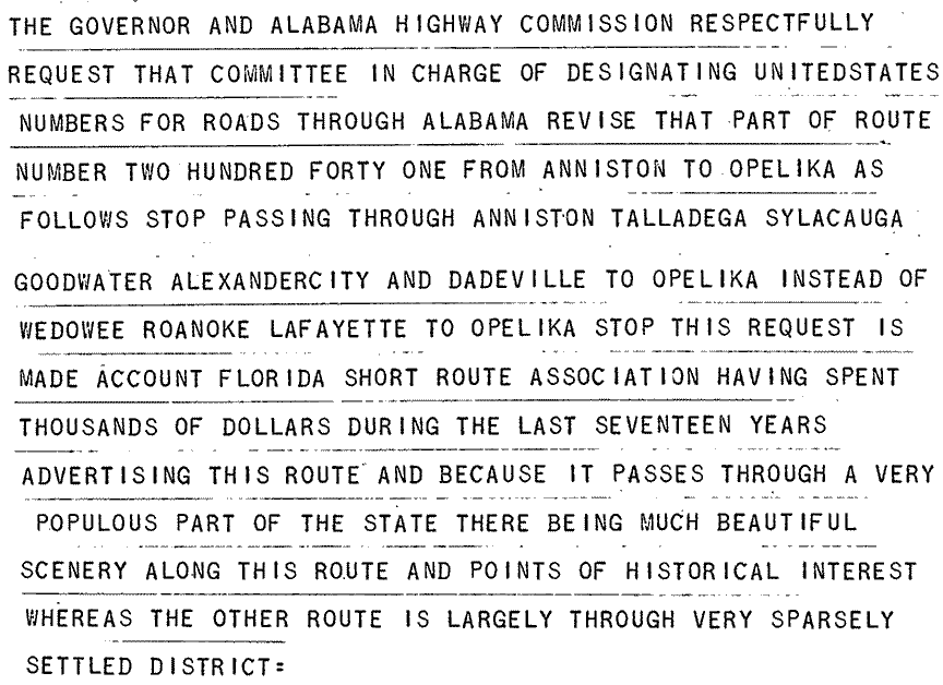
I find it a bit ironic that, by not allowing Alabama to signpost US 241 and SH 1 along the most direct highway, this so-called "Florida Short Route" organization was causing tourists to drive on a highway that took them about 27 miles out of their way.  That was exactly the sort of malpractice that the US route system was supposed to abolish.  But highways are a public expenditure, and it is hard to keep politics out of it.  Apparently AASHO did not push back, as they approved that change in Jan. 1931.  So that was the route of US 241 and SH 1 that was illustrated on Alabama's official 1931 map (the first one that showed the new US 241 designation).  It extended north from Huntsville, across the Tennessee line, through Fayetteville and Shelbyville to Murfreesboro, where it junctioned US 41 (which was the "parent route" implied by the number 241).

​
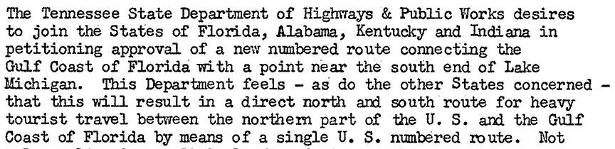
In 1935, at Florida's request, AASHO truncated US 231 about seven miles west of Marianna, and instead extended the route more southerly to a new terminus in Panama City.

​In 1942 AASHO conditionally approved Tennessee's request to extend the US 241 designation north from Murfreesboro through Lebanon to its junction with US 31E near Westmoreland.  The condition was that the highway had to be paved.  It appears Tennessee completed that work not long after, but there is no evidence that they ever extended the US 241 designation north of Murfreesboro.

So, by the early 1950s, US 231 was running northward from Panama City through Dothan to Montgomery, while US 241 began at Dothan and went north to Murfreesboro.  That was the timeframe during which the DOTs from several states began coordinating on a proposal for a new US highway.  This route was envisioned to run all the way from the Chicago area to the Gulf Coast, and would pass through areas of Indiana, Kentucky, Tennessee, Alabama, and Florida that were mostly unserved by any north-south US route.  The DOTs were aware that one option would have been to extend US 241 north from Murfreesboro to the Chicago area.  However, they were opposed to that idea because US 241 ended in Dothan, whereas they were quite insistent that one of the key features of this new route was that it should extend all the way to the Florida Gulf Coast.  That idea was present in this 1952 letter to AASHO from Kentucky:
Picture
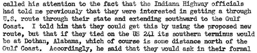
Besides that stipulation, Kentucky and Tennessee had an additional dilemma to factor into the proposal.  They wanted a US route designation applied to, not just one, but two different highways heading south from Owensboro KY.  The western route passed through Russellville KY and Nashville TN, while the eastern route passed through Bowling Green KY and Lebanon TN.  Each of these routes would rejoin in Fayetteville TN, but the mileage between Fayetteville and Owensboro was less via the western route.

In retrospect, it is easy to see an obvious solution that would have pleased all interests.  US 231 could have been extended north from Montgomery via Huntsville to Fayetteville, then along the shorter (western) route through Nashville to Owensboro, then up through Indiana to the northern terminus.  That would have created a Chicago-Gulf Coast route along the most direct corridor.  Then US 241 could have been extended north from Murfreesboro, via Bowling Green to Owensboro.  That would have addressed the eastern routing desired by Kentucky and Tennessee.  In fact, that is exactly the arrangement that was proposed in the petitions sent to AASHO by the Kentucky and Tennessee DOTs in Mar. 1952:
Picture
Picture
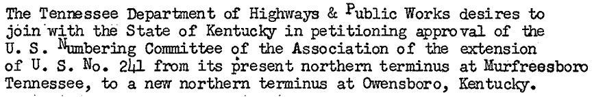
However, AASHO did not approve the requests exactly as they had been proposed by the states.  Why?  There were a couple factors.  For one thing, similar proposals for this Chicago-Gulf route had been sent to AASHO in years past, and they had been rejected primarily because AASHO was not convinced that the corridor actually merited a US route designation.  And more generally, AASHO had been growing increasingly frustrated because states were continually proposing new US routes, but many of them were somewhat frivolous.  If all of these routes were accepted into the system, then the US route shield was at risk of becoming rather meaningless.  

​So those were the concerns at top-of-mind for AASHO when they were asked to consider these proposals in 1952.  For those reasons, in July of that year, AASHO responded to the states by offering a counterproposal.  Their contingencies were as follows:
  • Alabama and Florida had originally proposed that the new route would head due south from Montgomery to the Gulf (via what would later become US 331), then curve eastward to Panama City.  AASHO determined that there would be no new US route south of Montgomery, but rather that the route to the Gulf would simply utilize the existing US 231.
  • North of Fayetteville, only one (not both) of the routes to Owensboro would receive a US route designation.  AASHO proposed extending US 231 via the eastern option (i.e. the longer option).  Presumably this was because 1.) Nashville was already quite well-served by US routes, and/or 2.) the routing north of Murfreesboro had been requested for quite some time.
  • Since US 231 would now occupy the US 241 corridor between Huntsville and Murfreesboro, the US 241 designation would be truncated to Huntsville.
In August each of the states accepted AASHO's counterproposal, and it was thus considered approved.  Following is the summary that AASHO provided to the state DOTs:
Picture
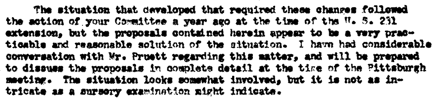
It is understandable why AASHO did not give the states exactly what they requested.  Yet because they did not, AASHO would very soon have to revisit the routes that had been left out, and unfortunately some less-than-ideal outcomes would result.

Already by October, Alabama and Florida submitted petitions for a new US route along the corridor that had just been denied (i.e. Montgomery to the Gulf near Santa Rosa Beach).  As a result, US route 331 was approved at AASHO's Dec. 1952 meeting.

In November, Kentucky and Tennessee applied for a US route between Owensboro and Springfield TN (where the new route would connect with US 41 heading into Nashville).  Tennessee's application specifically noted that a new US designation was desired because, although Nashville was actually the destination for a significant percentage of traffic heading south from Owensboro, the freshly-extended US 231 bypassed Nashville.  In Dec. 1952, AASHO deferred their decision on this route pending further study.  ​During the next couple months, it appears that AASHO must have been contacted by some very irate people.  No specific documentation to that effect was preserved in the AASHO archive, but this letter (sent by the Executive Secretary to the president of the Executive Committee on Route Numbering) leaves little room for misinterpretation:
Picture
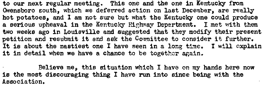
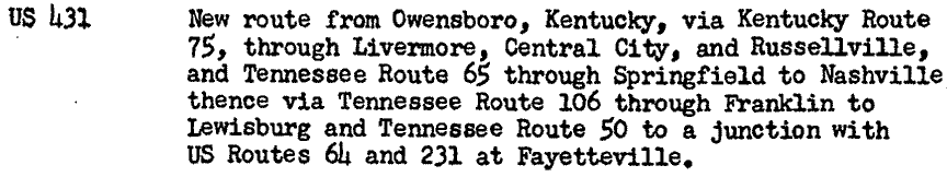
I can only speculate, but I suspect that folks were upset because the new Chicago-Gulf highway did not follow the shortest route, and/or because it did not pass through Nashville.  At any rate, AASHO had to revisit the proposal a third time in July 1953, and when they approved the new US 431, it was initially described as running between Owensboro and Fayetteville TN, where it junctioned US 231.  Following is that paragraph from AASHO's meeting minutes:
Picture
At this point, let's pause and give a little more thought to the situation that existed as a result of that action.  Between the south end of US 431 in Fayetteville and the north end of US 241 in Huntsville, there was a gap of only 30 miles.  To anyone looking at this arrangement on a map, it would seem quite obvious that US 241 should have been extended north from Huntsville to Fayetteville, and then followed the western route through Nashville, ending in Owensboro.  The US 431 designation was not needed.  But even after it was unnecessarily established in 1953, it still would have been apparent that either US 241 should be extended north, subsuming US 431; or else US 431 should be extended south, subsuming US 241.  Which of those options would have been best?  Well, US 241 ran about 335 miles from Dothan to Huntsville, and it had already been established for 23 years.  US 431, on the other hand, was a brand-new designation, and it was only about 205 miles in length.  So to me, it would have been a no-brainer: extend the longer, more-established route (US 241) north, and eliminate the brand-new, shorter US 431 designation.  If AASHO would have acted quickly enough, they could have made this change before US 431 had even been signposted.

​
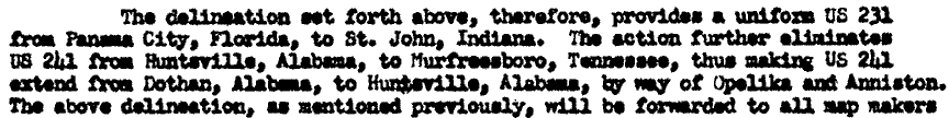
But that is not what actually happened.  In Aug. 1953 Alabama and Tennessee submitted a joint proposal to AASHO, requesting that US 431 be extended south to Dothan, replacing and eliminating US 241.  AASHO summarized the petition as follows:
Picture
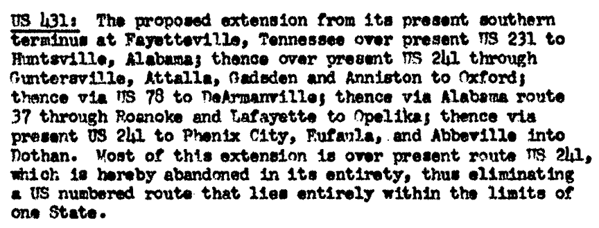
In a letter to the Route Numbering Executive Committee, the Executive Secretary used the phrase "your Committee", which was not typical, and which therefore seems to suggest that even he was not pleased with the previous decisions that had led up to this point:
Picture
Typically, the state DOTs were opposed to changing the number of a long-established US route, because this caused inconvenience to constituents who lived along that route, as well as confusion to drivers following maps that did not yet show the new number.  But the following excerpt from Alabama's petition may hint at the reason why Alabama actually supported the elimination of US 241:
Picture
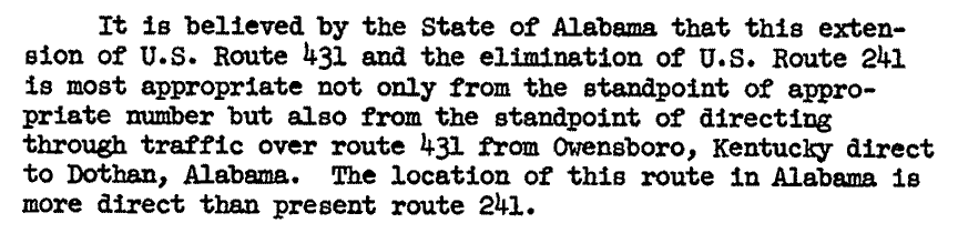
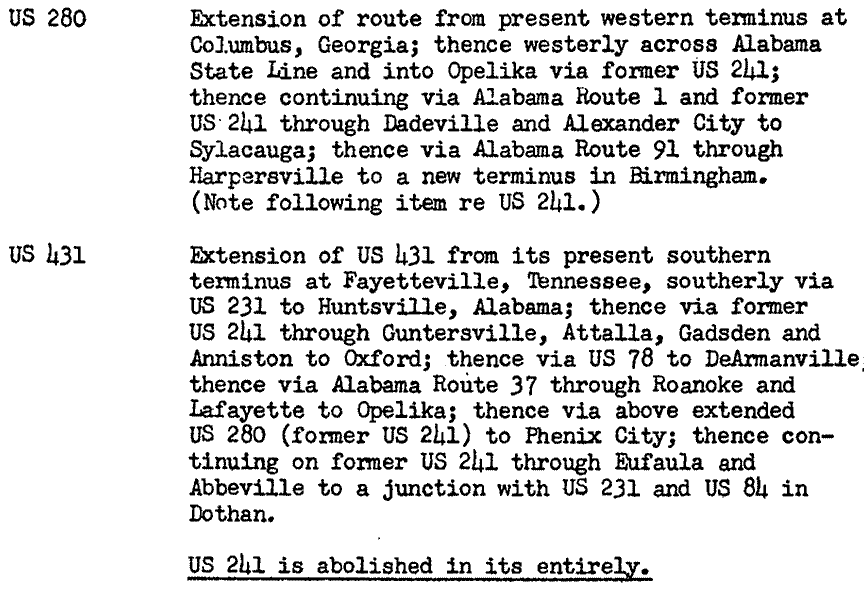
By that time it was obvious that US 241 should have been rerouted along the "Roanoke cutoff" mentioned previously.  But Alabama was probably concerned that they would cause another storm of protest if they proposed that.  They may have felt that it would involve less risk if they entirely eliminated US 241 and replaced it with a brand-new number that was defined to run along the shortest route between Huntsville and Dothan.  Also, they tried to mitigate any fallout by concurrently requesting the extension of US 280 westward from Columbus GA.  This extension covered the segment of former US 241 between Opelika and Sylacauga, leaving only the segment between Sylacauga and Oxford without a US route designation.  AASHO approved both of those proposals at their Nov. 1953 meeting:
Picture
So that is how it came to pass that US 241, a long-established route, was needlessly eliminated.  In its place was the new US 431 designation, and also the new US 231 and US 331.

Sources: multiple documents from AASHTO's Route Numbering Archive
0 Comments

Your comment will be posted after it is approved.


Leave a Reply.

    RSS Feed

    Author

    This guy.

    Categories

    All
    Arizona
    Boston
    California
    Colorado
    Denver
    Florida
    Geo-center
    Geography
    Historic
    Idaho
    Illinois
    Indiana
    Kansas
    Kentucky
    Maryland
    Massachusetts
    Michigan
    Midpoint
    Mileage
    Minnesota
    Missouri
    Nebraska
    New Hampshire
    New Jersey
    New Mexico
    Newport
    New York
    North Carolina
    North Dakota
    Numbering
    Oddity
    Ohio
    Oklahoma
    Oregon
    Pennsylvania
    Proposed
    Renumbering
    Signage
    South Carolina
    South Dakota
    Tennessee
    Texas
    Updates
    US 101
    US 127
    US 13
    US 136
    US 150
    US 154
    US 16
    US 160
    US 163
    US 164
    US 169
    US 177
    US 180
    US 183
    US 190
    US 191
    US 20
    US 210
    US 212
    US 218
    US 220
    US 23
    US 24
    US 25
    US 259
    US 26
    US 266
    US 27
    US 270
    US 271
    US 277
    US 281
    US 283
    US 285
    US 287
    US 3
    US 31
    US 311
    US 321
    US 34
    US 36
    US 360
    US 371
    US 377
    US 383
    US 385
    US 40
    US 400
    US 411
    US 450
    US 46
    US 48
    US 491
    US 50
    US 530
    US 55
    US 59
    US 6
    US 60
    US 61
    US 62
    US 63
    US 65
    US 66
    US 666
    US 67
    US 730
    US 74
    US 77
    US 80
    US 81
    US 83
    US 84
    US 85
    US 87
    US 89
    US 93
    US 94
    US 96
    US 99
    Utah
    Virginia
    Washington
    Watersheds
    West Virginia
    Wyoming

    Archives

    March 2023
    February 2023
    January 2023
    August 2022
    March 2022
    February 2022
    January 2022
    August 2021
    July 2021
    June 2021
    April 2021
    February 2021
    January 2021
    August 2020
    July 2020
    May 2020
    April 2020
    March 2020
    February 2020
    January 2020
    December 2019
    October 2019
    September 2019
    August 2019
    May 2019
    January 2019
    November 2018
    June 2018
    April 2018
    March 2018
    November 2017
    September 2017
    August 2017
    June 2017
    March 2017
    February 2017
    January 2017
    December 2016

Copyright © 1998-2023
Picture