US Ends .com
  • Home
  • Store
    • US highway map
    • Florida US highway map
  • Endpoints
    • US 1 - US 9 >
      • 1 >
        • 201
        • 301
        • 401 [i]
        • 401 [ii]
        • 401
        • 501
        • 601
        • 701
      • 2w >
        • 102
      • 2e >
        • 202
        • 302
      • 3
      • 4 >
        • 104
      • 5
      • 6 >
        • 106
        • 206
      • 7
      • 8
      • 9 >
        • 109*
        • 209
        • 309
    • US 10 - US 19 >
      • 10 >
        • 110
        • 210
        • 310
        • 410
      • 11 >
        • 111
        • 211
        • 311
        • 411 [i]
        • 411 [ii]
        • 411
        • 511*
        • 611
        • 711*
      • 12 >
        • 112
        • 212
        • 312
      • 13 >
        • 113
        • 213
      • 14
      • 15
      • 16 >
        • 116
        • 216
      • 17 >
        • 17-1
        • 117 [i]
        • 117
        • 217
      • 18 >
        • 118
        • 218
      • 19 >
        • 119
        • 219
        • 319
    • US 20 - US 29 >
      • 20 >
        • 120
        • 220
        • 320
        • 420
      • 21 >
        • 121 [i]
        • 121
        • 221
        • 321
        • 421
        • 521
      • 22 >
        • 122 [i]
        • 122 [ii]
        • 222
        • 322
        • 422e
        • 422w
        • 522
        • 622*
      • 23 >
        • 123 [i]
        • 123
        • 223
      • 24 >
        • 124
        • 224
      • 25
      • 26 >
        • 126
      • 27 >
        • 127
        • 227
      • 28
      • 29 >
        • 129
    • US 30 - US 39 >
      • 30 >
        • 130
        • 230
        • 330
        • 430
        • 530
        • 630*
        • 730
        • 830
      • 31 >
        • 131
        • 231
        • 331 [i]
        • 331
        • 431
      • 32
      • 33
      • 34
      • 35
      • 36 >
        • 136
      • 38 >
        • 138
    • US 40 - US 49 >
      • 40 >
        • 140
        • 240
        • 340
      • 41 >
        • 141
        • 241 [i]
        • 241 [ii]
        • 341
        • 441
        • 541
        • 641
      • 42
      • 43
      • 44
      • 45
      • 46
      • 48 [i]
      • 48 [ii]
      • 48
      • 49
    • US 50 - US 59 >
      • 50 >
        • 150
        • 250
        • 350
        • 450
        • 550
        • 650
      • 51 - 55 >
        • 51 >
          • 151
        • 52 >
          • 152
        • 53
        • 54 >
          • 154
        • 55
      • 56 >
        • 156
      • 57
      • 58 >
        • 158
        • 258
      • 59 >
        • 159
        • 259
    • US 60 - US 69 >
      • 60 >
        • 160
        • 260
        • 360
        • 460
      • 61 - 65 >
        • 61 >
          • 161
        • 62
        • 63 >
          • 163 [i]
        • 64 >
          • 164 [i]
          • 164 [ii]
          • 264
        • 65 >
          • 165
      • 66 >
        • 166
        • 266
        • 366 [i]
        • 366 [ii]
        • 466
        • 566
        • 666
      • 67 >
        • 167
      • 68 >
        • 168
      • 69 >
        • 169
    • US 70 - US 79 >
      • 70 >
        • 170
        • 270 [i]*
        • 270
        • 370
        • 470
      • 71 >
        • 171
        • 271
        • 371 [i]
        • 371
      • 72 - 76 >
        • 72
        • 73
        • 74
        • 75 >
          • 175
          • 275
        • 76 >
          • 176
          • 276
      • 77 >
        • 177
        • 277
        • 377
      • 78 >
        • 178
        • 278
        • 378
      • 79
    • US 80 - US 89 >
      • 80 - 84 >
        • 80 >
          • 180 [i]
          • 180
          • 280
          • 380
        • 81 >
          • 181
          • 281
        • 82
        • 83 >
          • 183
          • 283
          • 383
        • 84
      • 85 - 89 >
        • 85 >
          • 185
          • 285 [i]
          • 285
          • 385 [i]
          • 385
          • 485
        • 87 >
          • 187
          • 287
        • 89 >
          • 189 [i]
          • 189
    • US 90 - US 99 >
      • 90 - 94 >
        • 90 >
          • 190
          • 290
        • 91 >
          • 191
          • 491
        • 92 >
          • 192
        • 93
        • 94
      • 95 -98 >
        • 95 >
          • 195
          • 295
          • 395
        • 96 [i]
        • 96
        • 97 >
          • 197
        • 98
      • 99 >
        • 199
        • 299
        • 399
    • Anomalies >
      • 101
      • 163
      • 400
      • 412
      • 425
  • Places
    • A-L >
      • A >
        • Aberdeen
        • Albuquerque
        • Amarillo
        • Apalachicola
        • Astoria
        • Atlantic
      • B >
        • Baltimore
        • Baton Rouge
        • Bay Area
        • Bishop
        • Boone
        • Brady
        • Bristol
        • Brownsville
        • Brunswick
      • C >
        • Charleston
        • Chattanooga
        • Chicago
        • Cincinnati
        • Cleveland
        • Cody
        • Corpus
        • Cortez
        • Council Bluffs
        • Covington
        • Crescent
        • Cumberland Gap
      • D-E >
        • Dallas
        • Des Moines
        • Detroit
        • Dothan
        • Douglas
        • El Paso
        • Eugene
        • Erie
      • F >
        • Farmington
        • Flagstaff
        • Florence
        • Fox Valley
        • Franklin
      • G >
        • Gallup
        • Grand Junction
        • Grand Portage
        • Grayling
        • Great Falls
        • Greeley
      • H-I >
        • Hardeeville
        • Harrisburg
        • Holbrook
        • Idaho Falls
        • Int'l Falls
      • J-K >
        • Jacksonville
        • Joplin
        • Junction
        • Kansas City
        • Keokuk
        • Key West
        • Kingman
      • L >
        • Laredo
        • Lewiston
        • Long Beach
        • Los Angeles
        • Louisville
        • Lubbock
    • M-R >
      • M >
        • Mackinaw
        • Madison
        • Maryhill
        • Maysville
        • Miami
        • Midway
        • Miles City
        • Milford
        • Milwaukee
        • Minneapolis
        • Mobile 31
        • Mobile 31-43-45
        • Montgomery
        • Monticello
        • Mount Vernon
      • N-O >
        • Nags Head
        • Naples
        • Natchez
        • New Castle
        • New Orleans
        • Niagara
        • Norlina
        • Ocean City
        • Oklahoma City
      • P >
        • Pee Dee
        • Pembina
        • Pensacola
        • Petersburg
        • Philadelphia
        • Piegan
        • Pineville
        • Port Arthur
        • Portsmouth
      • Q-R >
        • Quad Cities
        • Rapid City
        • Raton
        • Reading
        • Richmond
        • Rockingham
        • Rouses Point
    • S-Z >
      • S >
        • San Antonio
        • San Antonio NM
        • San Diego
        • Santa Fe
        • Savannah
        • Sioux
        • Springer
        • Springfield
        • St. Ignace
        • St. John
        • St. Paul
        • St. Pete
      • T-U-V >
        • Tallahassee
        • Tampa
        • Toledo
        • Trinidad
        • Ucolo
        • VA Beach
      • W >
        • Walterboro
        • Waverly
        • West Memphis
        • Wilmington
        • Wilson
        • Wrightsville
      • Y >
        • Yellowstone E
        • Yellowstone N
        • Yellowstone NE
        • Yellowstone S
        • Yellowstone W
  • Highways
    • Map of all endpoints
    • Sources
    • History
    • 1926 almost-routes
    • Intra-state routes
    • Numbering
    • Colors
    • Blog
  • Bonus
    • Colorado >
      • Lowest point
      • Antipodes
      • Toponymy >
        • Roots
      • Colloquialisms
      • Populations
      • Denvers
    • Washington Meridian
    • Watersheds >
      • Headwaters Hill
      • Three Waters Mtn.
      • Parting of the Waters
    • Geo-centers >
      • 48 states
      • 50 states
      • North America
    • State corners >
      • AZ-CO-NM-UT
      • CO-UT-WY
      • CO-NE-WY
      • CO northeast
      • CO-KS-NE
      • CO-KS-OK
      • CO-NM-OK
      • NM-OK-TX
      • NM southeast
      • TX northwest
    • ooss.space
  • Connect
    • Author/history
    • Rationale
    • Contact
    • Contributors
    • Submissions

US Highways Blog

US route wannabes: Minnesota's rogue routes of 1934

1/13/2021

0 Comments

 
Some 1934 maps showed new US routes in Minnesota and/or extensions of US routes.  This was due to a series of errors and misunderstandings involving AASHO, MNDoT, and commercial map publishers.  By 1935 all of these misprints had been corrected.  I will explain in more detail below, but first I will jump ahead to the final analysis:
  • There was never a US 59 running through Rochester and southeastern Minnesota.  (The only US 59 that was ever signposted is the one that runs along the western edge of the state.)
  • US 65 was never signposted north of the Twin Cities.
  • US 212 was never signposted east of St. Paul (i.e. never to Stillwater).
  • US 218 was never signposted northwest of St. Paul (and probably never even north of Owatonna).
Background
In the original US route system (implemented in late 1926), US 10 had a split route in Minnesota between St. Cloud and Moorhead.  US 10-N followed what is now vanilla US 10 (through Little Falls, Motley, Wadena, and Detroit Lakes).  US 10-S essentially followed what is now the I-94 corridor (through Sauk Centre, Alexandria, and Fergus Falls).  Split routes quickly proved to be confusing to the driving public, and soon AASHO was encouraging the state DOTs to eliminate them (either by giving one of the branches an "Alternate" banner or else assigning one of the branches a completely different number).  MNDoT agreed and attempted to come up with their own solutions.
October 1933, first proposal
At the time, the north terminus of US 55 was in Minneapolis.  MNDoT contacted AASHO to suggest that the US 55 designation be extended northwest from there, replacing US 10-N (and US 10-S would then become simply US 10).  Incidentally, the same letter proposed some additional changes:
  • Extend US 8 west along what would later become the easternmost segment of US 212, subsuming the existing US 212 from Montevideo to its western terminus in South Dakota.
  • Move the US 61 designation to serve Minneapolis - St. Cloud - Little Falls - Brainerd - Bemidji (thus replacing US 371 in its entirety).
  • Instead of ending in Minneapolis, extend US 65 along the former US 61 (through Duluth and along the North Shore).
  • Extend the US 53 designation north from Duluth to the city of Virginia, and then replace US 169 from there to International Falls (this particular change was eventually approved).
  • Notably absent from this proposal (and all others that followed) was the idea to change state highway 59 (which ran north and south both directions out of Rochester MN) to US highway 59.  That suggestion appears to have been sent to AASHO by local interests, but I have not seen any official proposals (or indication of support) from MNDoT.
In their response to MNDoT's ideas, AASHO expressed concern about US 61 being west of US 65, as well as US 8 running south of US 12 (they suggested swapping the US 8 and US 12 corridors west of Minneapolis).  ​
Get your very own map showing all current and historic US routes!

October 1933, second proposal
MNDoT addressed some of AASHO's concerns as follows:
  • Truncate US 8 short of Minneapolis, instead extending it due west through Anoka, then to St. Cloud, then replacing US 10-N to Moorhead.
  • US 210 had been numbered as such because of its connection with US 10 at Motley.  But since US 10 would become US 8 under this proposal, MNDoT suggested changing US 210 to US 208.
  • Remove the US 212 designation from the Montevideo - Willmar corridor, instead extending it west via Granite Falls - Olivia - Glencoe - Chaska (this particular change was eventually ​approved).
In its response, AASHO was favorable to the US 8 proposal, and expressed no concerns about MNDoT's other ideas, although everything would be contingent upon approval at an upcoming committee meeting.
November 1933 proposal
MNDoT expressed their desire to extend US 212 further east from Chaska, through the Twin Cities and to the Wisconsin border at Stillwater.  AASHO's response again indicated favorability, but again contingent upon approval.
January 1934 proposal
MNDoT contacted AASHO again, noting that Minneapolis interests were opposed to removing the US 8 designation from their city, so instead this time it was the US 218 designation that MNDoT proposed as a replacement for US 10-N (it is unclear why they suggested that, instead of going back to the earlier US 55 proposal).  They also included some other ideas in this letter:
  • Extend US 65 north to a junction with US 71 at Littlefork.
  • Instead of truncating US 169 at its junction with US 53 in Virginia, extend it northeast to Tower.
  • Create the US 261 designation as a connection between Minneapolis and Hastings.
  • Even though this latest proposal had US 218 (instead of US 8) running through Motley, MNDoT still wanted US 210 to be changed to US 208 (rather than, say, US 318).
AASHO's response simply noted that the suggestions would be brought up at their June meeting.  Ultimately none of those five proposals were accepted.  I have not seen a letter expressly denying them, but since only one of them (the extension of US 65) was illustrated on Minnesota's 1934 map, I interpret that to mean that AASHO must have communicated that those other four specific changes would not be accepted during their upcoming meeting.  AASHO also must have pulled back the curtain on some of their broader-scale plans, most notably the extension of US 52.  At the time the northwest terminus of US 52 was in Indiana, but AASHO was about to extend the route in both directions in order to absorb and replace some shorter routes.  Specifically in Minnesota, US 52 would replace US 55 southeast of the Twin Cities, and US 10-S northwest of there.  That change was accurately portrayed on MNDoT's 1934 map.  However, AASHO must not have completely closed the door on some of MNDoT's other proposals (such as the US 65 extension), because in May they published a map which prematurely and erroneously included some of their other suggested changes.  
Minnesota Highway Department's infamous May 1934 map
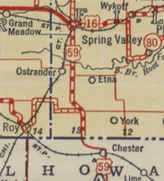
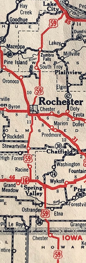
Unfortunately MNDoT went rogue by opting to include some of their proposed route changes on their 1934 map.  This was printed in May prior to AASHO's June meeting, during which these suggested routes would be rejected.  One of these errors was a "US 59" running north and south out of Rochester to the borders of Wisconsin and Iowa:
Picture
MNDoT, c. 1934, "US 59" south of Rochester
Incidentally, some of these maps show US 59 crossing the border into Iowa, but I have never seen an Iowa map (government or commercial) corroborating a "US 59" in the northeast part of that state.
Picture
MNDoT, c. 1934, "US 59" north of Rochester

Another erroneous route was US 65 north of the Twin Cities.  For some reason the map showed US 65 ending at jct. US 210 in McGregor.  As originally proposed, US 65 was to extend all the way up to US 71 at Littlefork, but on this map the route north of McGregor was shown as state highway 65:
Picture
MNDoT, c. 1934, "US 65" south of US 210
The Twin Cities inset showed US 65's planned route northward from its actual terminus in downtown Minneapolis:
Picture
MNDoT, c. 1934, "US 65" north of Minneapolis
That same inset map also showed the US 212 designation extending through St. Paul to Stillwater:
Picture
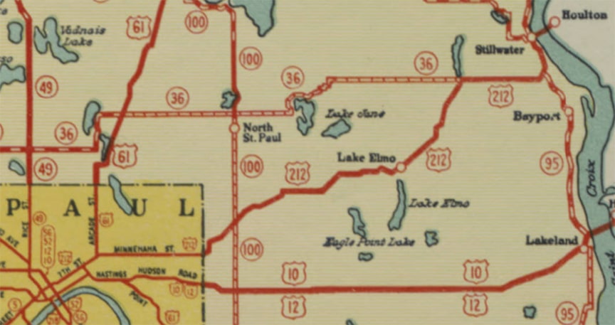
MNDoT, c. 1934, "US 212" east of Minneapolis
And finally, the map also showed US 218 extending north of Owatonna, through the Twin Cities, and up to jct. US 210 in Brainerd.  It is unclear why the US 218 designation was not shown to replace the remainder of the US 371 designation between Brainerd and Bemidji:
Picture
MNDoT, c. 1934, "US 218" north to Brainerd
Collateral damage
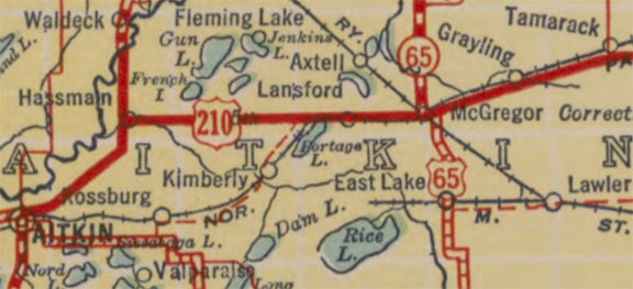
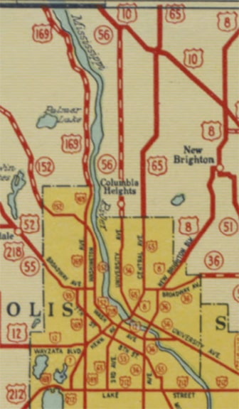
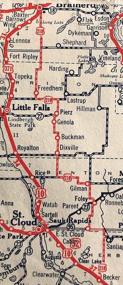
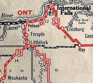
These errors were not confined only to MNDoT's map.  They were also shown on some commercial maps (which is understandable since publishers relied heavily on state maps for source material).  For example, here is a 1934 Rand McNally that showed US 65 north of Minneapolis; US 212 to Stillwater; and US 218 north of Owatonna:
Picture
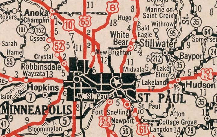
Rand McNally, c. 1934
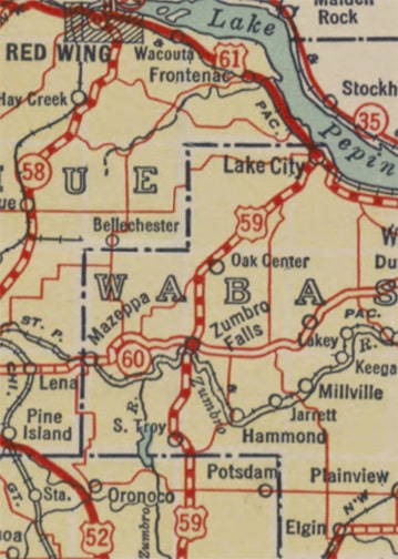
On that map US 218 was shown ending in the Twin Cities (instead of continuing up to Brainerd), and US 65 was shown to end at US 210 in McGregor.  That same map also showed "US 59" in the southeastern part of the state.  And there was at least one more 1934 commercial map (Gallup) that also showed those same errors, including US 212 to Stillwater, and US 59 along the Rochester corridor:
Picture
Gallup, c. 1934, "US 59" through Rochester
Picture
Gallup, c. 1934, "US 218" north to Brainerd
There were some slight differences.  For example, in that last image, US 218 was shown following an alignment independent of US 10 / US 371 between Brainerd and Becker.  US 169 was shown northeast of Virgina, ending at Tower.  And in this next image, US 65 was shown continuing north of US 210 at McGregor and going all the way up to US 71 at Littlefork (even though the road was shown as incomplete to the south of Littlefork).  But the bottom line is, there were plenty of 1934 maps that erroneously showed US route extensions in Minnesota which were never signposted and never approved by AASHO.
Picture
Gallup, c. 1934, "US 65" north to Littlefork
Communication and decisions through the rest of 1934 and into 1935
At the time of this writing (Jan. 2021) some of the relevant documents were missing from the database I used for research.  Nevertheless, I believe I have been able to piece together most of what happened with regard to the routes in question. 
  • Officials with AASHO and MNDoT had a meeting on May 21, which must have been shortly after MNDoT had published their map.  According to a June 12 letter from MNDoT, it was during that May meeting AASHO when revealed that, instead of a new US 59 designation in southeast Minnesota, that route would become part of US 63, which was to be extended northward from Iowa.  They also at least hinted that US 218 would not be extended north of the Twin Cities.
  • AASHO held their annual meeting on June 22.  Numerous changes to US routes were made across the country, but unfortunately I have not yet seen the meeting minutes.  On August 20 AASHO sent a letter to MNDoT, requesting Minnesota's mileages along the new and/or changed US routes.  MNDoT responded on September 7, and their letter reveals a few of the decisions AASHO had made in June.  Among them: US 63 was extended north through Rochester.  Rather than designating that route as US 59, that number was instead used on a new route that ran through western Minnesota.  US 65's north terminus was in Minneapolis (not north of there).  The north terminus of US 218 apparently was to remain in Owatonna.
  • After AASHO's June 1934 meeting (and at least as late as September), it seems that US 212 was expected to extend east not just to Stillwater, but also all the way across Wisconsin (using today's state highway 64), ending at its junction with US 41 in Marinette.  I have not seen any documentation retracting that decision, but I do know that by the time MNDoT's 1935 map was printed, US 212 did not even make it further east than the Twin Cities, much less anywhere in Wisconsin.
  • Also on MNDoT's 1935 map, US 65 was shown to end in Minneapolis (with state trunk highway 65 extending north from there); US 218 ended in Owatonna (with TH 218 extending north of there).  US 63 was shown in southeastern Minnesota, and the new US 59 was shown in the western part of the state.  
In other words, the 1935 map corrected the mistakes shown on the 1934 map, on which MNDoT had made some erroneous assumptions about the US route decisions that AASHO would make later in 1934.  So, even though some maps suggest otherwise, US 59 only existed in western Minnesota, never in the southeastern part of the state.  US 65 never went further north than Minneapolis; US 212 never went east of the Twin Cities; and US 218 never went north of Owatonna.
Sources:
AASHO Route Numbering Archive
MNDoT historic state highway maps
Rand McNally 1934 atlas
​Gallup 1934 atlas (physical copy)
0 Comments

Your comment will be posted after it is approved.


Leave a Reply.

    RSS Feed

    Author

    This guy.

    Categories

    All
    Arizona
    Boston
    California
    Colorado
    Denver
    Florida
    Geo-center
    Geography
    Historic
    Idaho
    Illinois
    Indiana
    Kansas
    Kentucky
    Maryland
    Massachusetts
    Michigan
    Midpoint
    Mileage
    Minnesota
    Missouri
    Nebraska
    New Hampshire
    New Jersey
    New Mexico
    Newport
    New York
    North Carolina
    North Dakota
    Numbering
    Oddity
    Ohio
    Oklahoma
    Oregon
    Pennsylvania
    Proposed
    Renumbering
    Signage
    South Carolina
    South Dakota
    Tennessee
    Texas
    Updates
    US 101
    US 127
    US 13
    US 136
    US 150
    US 154
    US 16
    US 160
    US 163
    US 164
    US 169
    US 177
    US 183
    US 190
    US 191
    US 20
    US 210
    US 212
    US 218
    US 220
    US 23
    US 24
    US 25
    US 259
    US 26
    US 266
    US 27
    US 270
    US 271
    US 277
    US 281
    US 283
    US 285
    US 287
    US 3
    US 31
    US 311
    US 321
    US 34
    US 36
    US 360
    US 371
    US 377
    US 383
    US 385
    US 40
    US 400
    US 411
    US 450
    US 46
    US 48
    US 491
    US 50
    US 530
    US 55
    US 59
    US 6
    US 60
    US 61
    US 62
    US 63
    US 65
    US 66
    US 666
    US 67
    US 730
    US 74
    US 77
    US 81
    US 83
    US 84
    US 85
    US 87
    US 89
    US 93
    US 94
    US 96
    US 99
    Utah
    Virginia
    Washington
    Watersheds
    West Virginia
    Wyoming

    Archives

    August 2022
    March 2022
    February 2022
    January 2022
    August 2021
    July 2021
    June 2021
    April 2021
    February 2021
    January 2021
    August 2020
    July 2020
    May 2020
    April 2020
    March 2020
    February 2020
    January 2020
    December 2019
    October 2019
    September 2019
    August 2019
    May 2019
    January 2019
    November 2018
    June 2018
    April 2018
    March 2018
    November 2017
    September 2017
    August 2017
    June 2017
    March 2017
    February 2017
    January 2017
    December 2016

Copyright © 1998-2023
Picture