|
(last updated 3/7/2022)
Many Route 66 tourists simply enjoy the romance and the lore of the fabled road. The facts aren't all that important, and if one of the legends turns out to be a tall-tale, they'd rather not know about it. And that's fine -- if you're one of those people, I say you gotta do you -- get out there and enjoy the Mother Road.
...then you might want to stop reading here, because this page contains research that discredits some of the "conventional wisdom" about US 66 that is found elsewhere. On the other hand, if you're interested in facts and details, then please carry on.
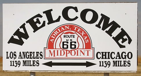
Above is a photo of the sign that prompted all this research. Upon seeing that, my train of thought went something like this: "Hmm, midpoint of US 66, interesting. Hmm, 1139 miles, wonder if that's accurate. Hmm, it says "Los Angeles" instead of "Santa Monica", I wonder why? US 66 ended in Santa Monica for a lot longer than it ended in L.A. So I wonder where the midpoint was after 1935? And weren't there some pretty major changes to the alignment? Those would've affected the midpoint..."
That's how it all started... and at this point I'm going to jump straight to the conclusion by providing the answers to the questions above, in case you don't want to wade through the lengthy description of the process that yielded these answers:
I do apologize for bursting so many bubbles. If you would like more details about those first three answers, please check out the main US 66 page and the Chicago page.
Questions arise
First, I did a quick check using Google Maps. Along the interstates, the mileage from Adrian to Los Angeles is about 1025 miles, but Adrian to Chicago is just over 1100 miles. Of course I do realize that US 66's route was not exactly the same as the modern interstates, and that one or more of its various alignments could have been longer. But on the other hand, it was the interstates that ultimately led to US 66's demise. So that suggested the 75-mile discrepancy between distances from Adrian probably couldn't be due solely to alignment changes. This was worth researching more deeply.
The parameters
Every time a bypass was built or an alignment was changed, that affected the mileage and the midpoint. So the mileage of US 66 was a constantly-shifting number, and its midpoint was at an ever-changing location. OK, that's true, but still: how many of those realignments would have caused a significant impact to the total mileage? Probably not very many. I determined that I would have to come up with a list along with a timeline. That way I could measure US 66's mileage once, at a specific point in time, and then simply add or subtract from that figure based on the major differences in alignments that took place over the years. (Although that is a quite labor-intensive task; click here for the reasons why.) I got help from some members of the aaroads forum, and came up with the following:
...so for that reason, I decided not to even attempt calculating the mileage of US 66 during its natal years. Instead, for that information we could try looking at AASHO's early route logs:
c. 1927
c. 1929
The 51-mile difference strikes me as unlikely (especially since the mileage increased). So I'm guessing at least one of those measurements was inaccurate, but I don't have a way to prove it.
So, we are concerned with the roughly three decades from 1932-1964. Within that timeframe there are essentially only two different alignments that had differences worth taking into account:
The research
Following are my measurements per state (and, where applicable, per timeframe):
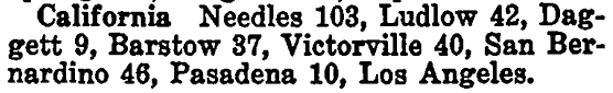
California
Arizona
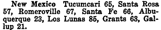
New Mexico
Cumulative heading eastbound at the NM-TX state line (1936-1964): 1071.3 miles Texas
Cumulative heading westbound at the OK-TX state line (1936-1964): 999.6 miles Oklahoma
Kansas
Missouri
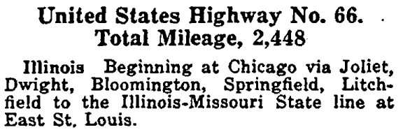
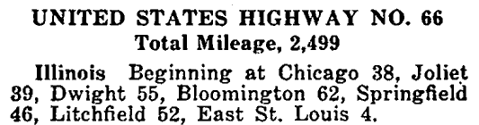
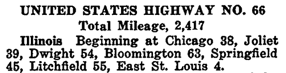
Illinois
So how long was US 66?
There is no single answer to that question. Rather, the answer was different during different timeframes.
c. 1935
The figure quoted there was 82 miles shorter than the one AASHO had listed six years earlier, but on the other hand it is still 83 miles longer than my own measurement. It is hard to know how to account for that discrepancy. It is possible that US 66 was still using its original "stair-step" alignments in some areas (rather than the diagonal alignments that came later). It is also possible that AASHO was including the mileage of bannered routes associated with US 66 (rather than just the mainline route; they are known to have done that in later years).
For a more succinct answer, one could say that US 66 was about 2350 miles long for its first decade, but during its final three decades it was more like 2250 miles long. Of course, as I've already mentioned, those numbers changed a bit every time a new alignment was built. For example: right around 1950 (give or take a few years), two changes in Arizona shaved a combined five miles off the length of US 66. Near Flagstaff, US 66 was moved off Winona-Townsend Road, and it was also moved away from its original alignment that went through Oatman. That five-mile reduction to the western half of US 66 would have pushed the midpoint 2.5 miles further east. But it still would have been between Wildorado and Bushland, so I do not consider that a significant change.
Was Adrian really the midpoint of US 66?
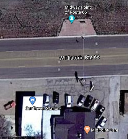
Adrian has certainly come to be thought of as the midpoint, and that will probably never change. After all, it says so right on the town's water tower. And there is an eatery in town called the Midpoint Cafe. Right across the historic highway from there is a small easement where tourists can have a photo opp with the sign shown at the top of this page. Between there and the cafe is a white stripe running across the road, painted with the word "MIDPOINT", giving the impression that the exact midpoint is right there. All of that can be seen in this aerial photo:
During the earliest years of the US route system -- when the roads were dusty and the history is still a little hazy -- Adrian and Glenrio could have had a legitimate debate about which one of them held the right to declare themselves the closest town to the midpoint of US 66. At that time the west end of US 66 was in Los Angeles, so as it turns out, it is indeed appropriate to have that city (rather than Santa Monica) referenced on the sign posted in Adrian.
But already by 1935 Adrian had lost any claim to the midpoint of US 66. And by 1937 the midpoint had shifted quite a ways to the east, such that any battle for the title should have been between Wildorado and Bushland, with Adrian only spectating from about 40 miles away.
That is posted on one of the exterior walls of the Midpoint Cafe. Those types of signs can be found at attractions along the entire length of Historic 66, so again, the Midpoint Cafe is probably not responsible for its verbiage. Rather, I suspect (but am not certain) that it is the Route 66 Association that produces those signs.
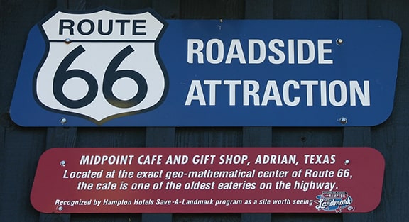
"Exact geo-mathematical center of Route 66"? What is that supposed to mean? Is that somehow different than the "plain-vanilla" midpoint? I find it a bit off-putting that such an academic-sounding term was used, when 1.) it is apparent that the so-called "midpoint" was calculated without much academic rigor, and 2.) "geo-mathematical center" is not even a thing. I am also disappointed that there was no mention of the varying length of US 66 over the years, nor an acknowledgement that the location of the midpoint was not static. As it is, that sign leans towards gimmicky marketing propaganda. But on the other hand, maybe it fits well with the mid-century version of gaudy commercialism, which for some is also a part of Route 66's appeal.
2 Comments
Tracy Snead
3/11/2020 11:29:17 am
Thank you for the great work.
Glenn Hargrave
9/17/2020 08:49:07 am
There is a sign inside the Midpoint Cafe for the National Old Trails road stating that it is 1139 miles to LA and Chicago. Since the NOT predates Route 66 one can assume that it is correct if that sign is legit. Your comment will be posted after it is approved.
Leave a Reply. |
AuthorCategories
All
Archives
July 2024
|

 RSS Feed
Copyright © 1998-2024
