US Ends .com
  • Home
  • Store
    • US highway book
    • US highway map
    • Florida US highway map
  • Endpoints
    • US 1 - US 9 >
      • 1 >
        • 201
        • 301
        • 401 [i]
        • 401 [ii]
        • 401
        • 501
        • 601
        • 701
      • 2w >
        • 102
      • 2e >
        • 202
        • 302
      • 3
      • 4 >
        • 104
      • 5
      • 6 >
        • 106
        • 206
      • 7
      • 8
      • 9 >
        • 109*
        • 209
        • 309
    • US 10 - US 19 >
      • 10 >
        • 110
        • 210
        • 310
        • 410
      • 11 >
        • 111
        • 211
        • 311
        • 411 [i]
        • 411 [ii]
        • 411
        • 511*
        • 611
        • 711*
      • 12 >
        • 112
        • 212
        • 312
      • 13 >
        • 113
        • 213
      • 14
      • 15
      • 16 >
        • 116
        • 216
      • 17 >
        • 17-1
        • 117 [i]
        • 117
        • 217
      • 18 >
        • 118
        • 218
      • 19 >
        • 119
        • 219
        • 319
    • US 20 - US 29 >
      • 20e >
        • 120
        • 220
        • 320
        • 420
      • 20w
      • 21 >
        • 121 [i]
        • 121
        • 221
        • 321
        • 421
        • 521
      • 22 >
        • 122 [i]
        • 122 [ii]
        • 222
        • 322
        • 422e
        • 422w
        • 522
        • 622*
      • 23 >
        • 123 [i]
        • 123
        • 223
      • 24 >
        • 124
        • 224
      • 25
      • 26 >
        • 126
      • 27 >
        • 127
        • 227
      • 28
      • 29 >
        • 129
    • US 30 - US 39 >
      • 30 >
        • 130
        • 230
        • 330
        • 430
        • 530
        • 630*
        • 730
        • 830
      • 31 >
        • 131
        • 231
        • 331 [i]
        • 331
        • 431
      • 32
      • 33
      • 34
      • 35
      • 36 >
        • 136
      • 38 >
        • 138
    • US 40 - US 49 >
      • 40 >
        • 140
        • 240
        • 340
      • 41 >
        • 141
        • 241 [i]
        • 241 [ii]
        • 341
        • 441 >
          • 441n
          • 441s
        • 541
        • 641
      • 42
      • 43
      • 44
      • 45
      • 46
      • 48 [i]
      • 48 [ii]
      • 48
      • 49
    • US 50 - US 59 >
      • 50 >
        • 150
        • 250
        • 350
        • 450
        • 550
        • 650
      • 51 - 55 >
        • 51 >
          • 151
        • 52 >
          • 152
        • 53
        • 54 >
          • 154
        • 55
      • 56 >
        • 156
      • 57
      • 58 >
        • 158
        • 258
      • 59 >
        • 159
        • 259
    • US 60 - US 69 >
      • 60 >
        • 160
        • 260
        • 360
        • 460
      • 61 - 65 >
        • 61 >
          • 161
        • 62
        • 63 >
          • 163 [i]
        • 64 >
          • 164 [i]
          • 164 [ii]
          • 264
        • 65 >
          • 165
      • 66 >
        • 166
        • 266
        • 366 [i]
        • 366 [ii]
        • 466 [i]*
        • 466 [ii]
        • 566
        • 666
      • 67 >
        • 167
      • 68 >
        • 168
      • 69 >
        • 169
    • US 70 - US 79 >
      • 70 >
        • 170
        • 270 [i]*
        • 270
        • 370
        • 470
      • 71 >
        • 171
        • 271
        • 371 [i]
        • 371 [ii]
        • 371
      • 72 - 76 >
        • 72
        • 73
        • 74
        • 75 >
          • 175
          • 275
        • 76 >
          • 176
          • 276
      • 77 >
        • 177
        • 277
        • 377
      • 78 >
        • 178
        • 278
        • 378
      • 79
    • US 80 - US 89 >
      • 80 - 84 >
        • 80 >
          • 180 [i]
          • 180
          • 280
          • 380
        • 81 >
          • 181
          • 281
        • 82
        • 83 >
          • 183
          • 283
          • 383
        • 84
      • 85 - 89 >
        • 85 >
          • 185
          • 285 [i]
          • 285
          • 385 [i]
          • 385
          • 485
        • 87 >
          • 187
          • 287n
          • 287s
        • 89n
        • 89s >
          • 189 [i]
          • 189
    • US 90 - US 99 >
      • 90 - 94 >
        • 90 >
          • 190
          • 290
        • 91 >
          • 191 >
            • 191n
            • 191s
          • 491
        • 92 >
          • 192
        • 93
        • 94
      • 95 -98 >
        • 95 >
          • 195
          • 295
          • 395
        • 96 [i]
        • 96
        • 97 >
          • 197
        • 98
      • 99 >
        • 199
        • 299
        • 399
    • Anomalies >
      • 101
      • 163
      • 400
      • 412
      • 425
  • Places
    • A-L >
      • A >
        • Aberdeen
        • Albuquerque
        • Amarillo
        • Apalachicola
        • Astoria
        • Atlantic
      • B >
        • Baltimore
        • Baton Rouge
        • Bay Area
        • Bishop
        • Boone
        • Brady
        • Bristol
        • Brownsville
        • Brunswick
      • C >
        • Charleston
        • Chattanooga
        • Chicago
        • Cincinnati
        • Cleveland
        • Cody
        • Corpus
        • Cortez
        • Council Bluffs
        • Covington
        • Crescent
        • Cumberland Gap
      • D-E >
        • Dallas
        • Des Moines
        • Detroit
        • Dothan
        • Douglas
        • El Paso
        • Erie
        • Eugene
      • F >
        • Farmington
        • Flagstaff
        • Florence
        • Fox Valley
        • Franklin
      • G >
        • Gallup
        • Georgetown
        • Grand Junction
        • Grand Portage
        • Grayling
        • Great Falls
        • Greeley
      • H-I >
        • Hardeeville
        • Harrisburg
        • Holbrook
        • Idaho Falls
        • Int'l Falls
      • J-K >
        • Jacksonville
        • Joplin
        • Junction
        • Kansas City
        • Keokuk
        • Key West
        • Kingman
      • L >
        • Laredo
        • Lewiston
        • Long Beach
        • Los Angeles
        • Louisville
        • Lubbock
    • M-R >
      • M >
        • Mackinaw
        • Madison
        • Maryhill
        • Maysville
        • Miami
        • Midway
        • Miles City
        • Milford
        • Milwaukee
        • Minneapolis
        • Mobile 31
        • Mobile 31-43-45
        • Montgomery
        • Monticello
        • Mount Vernon
      • N-O >
        • Nags Head
        • Naples
        • Natchez
        • New Castle
        • New Orleans
        • Niagara
        • Norlina
        • Ocean City
        • Oklahoma City
      • P >
        • Pee Dee
        • Pembina
        • Pensacola
        • Petersburg
        • Philadelphia
        • Piegan
        • Pineville
        • Port Arthur
        • Portsmouth
      • Q-R >
        • Quad Cities
        • Rapid City
        • Raton
        • Reading
        • Richmond
        • Rockingham
        • Rouses Point
    • S-Z >
      • S >
        • San Antonio
        • San Antonio NM
        • San Diego
        • Santa Fe
        • Savannah
        • Sioux
        • Springer
        • Springfield
        • St. Ignace
        • St. John
        • St. Paul
        • St. Pete
      • T-U-V >
        • Tallahassee
        • Tampa
        • Toledo
        • Trinidad
        • Tuba City
        • Ucolo
        • VA Beach
      • W >
        • Walterboro
        • Waverly
        • West Memphis
        • Wilmington
        • Wilson
        • Wrightsville
      • Y >
        • Yellowstone E
        • Yellowstone N
        • Yellowstone NE
        • Yellowstone S
        • Yellowstone W
  • Highways
    • Map of all endpoints
    • Sources
    • History
    • 1926 almost-routes
    • Intra-state routes
    • Numbering
    • Colors
    • Gaps
    • Blog
  • Bonus
    • Colorado >
      • Lowest point
      • Antipodes
      • Toponymy >
        • Roots
      • Colloquialisms
      • Populations
      • Denvers
    • Washington Meridian
    • Watersheds >
      • Headwaters Hill
      • Three Waters Mtn.
      • Parting of the Waters
    • Geo-centers >
      • 48 states
      • 50 states
      • North America
    • State corners >
      • AZ-CO-NM-UT
      • CO-UT-WY
      • CO-NE-WY
      • CO northeast
      • CO-KS-NE
      • CO-KS-OK
      • CO-NM-OK
      • NM-OK-TX
      • NM southeast
      • TX northwest
  • Connect
    • Author/history
    • Rationale
    • Contact
    • Contributors
    • Submissions

US Highways Blog

Why US 285 should be signed east-west in the Denver area

6/25/2021

5 Comments

 
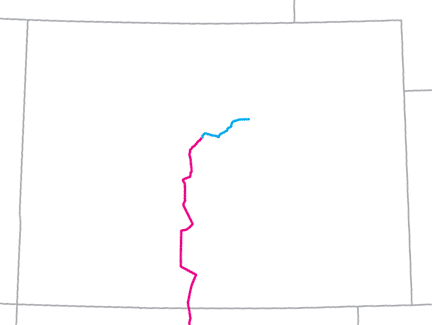
I am about to ask a simple question.  It is not a trick question, so no reason to over-think it.  The map below (like most maps) is oriented with north at the top.  You might not be able to make out much detail, but that's ok, because all I want you to do is take a look at the highway shown in blue.  And the question is simply this: does this highway run north-south?  Or does it run east-west?
Picture
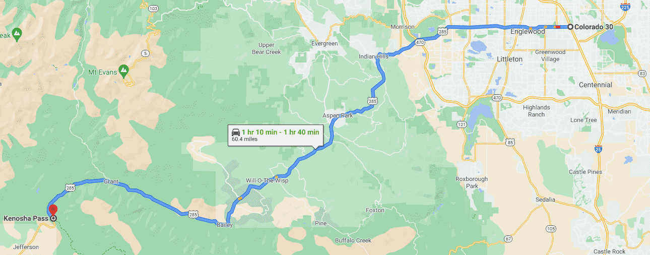
Here is another way to ask the question: let's say you were to drive the blue route from the point on the left side to the point on the right.  If you had to describe the general direction of your movement using only one of the following two words, which one would you choose: north or east?  Obviously the road is not perfectly straight, but I hope you can agree that the highway generally runs east-west. 

In case that is not plain to see, consider this data: the total distance along the blue line is about 60 miles.  The rise of the highway (the variance between its northernmost point and its southernmost) is about 16 miles.  But its run (its east-west span) is 42 miles, which is over 2.5 times greater than its rise.

Now, here are a few more details about that map: the highway shown in blue is a segment of U.S. Route 285.  The marker in the lower left is at Kenosha Pass (in the mountains about an hour outside of Denver).  In the upper right is the southern part of the Denver metro area.  Let's zoom in on that ​section of the map.  Note how this particular segment of the highway comes close to having a due east-west orientation:
Picture
​But here's the thing: US 285 is actually not signposted east-west.  Rather, it is signed north-south.
Get your very own map showing all current and historic US routes!

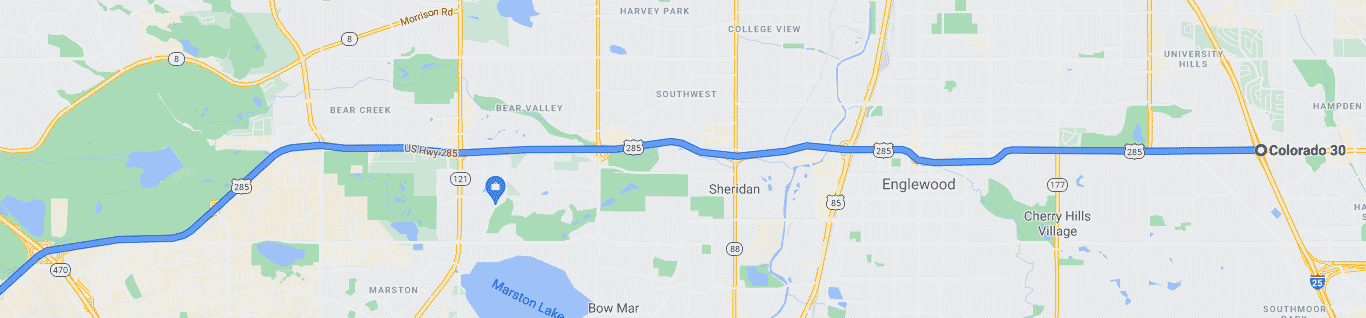
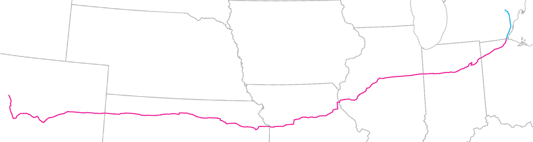
At first glance that may seem ridiculous, but here I will briefly sabotage my own argument by stating that there is a rational explanation why the Colorado Department of Transportation (CDOT) signs US 285 as a north-south route.  The map below shows US 285 in its entirety: 846 miles through Colorado, New Mexico, and Texas:
Picture
US 285 runs between Colorado (top) and Texas (bottom), with most of its mileage in New Mexico (center).
Clearly the overall direction of US 285 is north-south.  Highways that ultimately trend north-south are usually signposted that way, even along segments of the route that happen to run more east-west.  That is standard practice in the U.S. and that is why CDOT signs US 285 north-south.

That being said, there are numerous examples in other states where the signposted direction on a US route changes from north-south to east-west (or vice versa).  These other state DOTs have done this on highways where it would not make sense follow conventional signage practices.  Here are some examples:

U.S. Route 41 is a long north-south highway, running from Michigan to Florida.  However, in south Florida, US 41 makes a rather sharp turn to the east, and in the Miami area the highway runs essentially due east to its endpoint.  So in Miami-Dade County, the Florida DOT uses east-west directional signage on US 41 (instead of north-south).  Why did they exempt this segment of US 41 from the conventional method of signposting highways?  Two main reasons:
  • In south Florida, US 41 ceases its function as a north-south route.  Instead, it begins functioning as an east-west route, and US 41 ends without ever resuming a north-south direction-of-travel.
  • Miami is a major metropolitan area, and every day thousands of drivers heading north or south come to an intersection with SW 8th Street (which carries US 41).  The vast majority of people who turn west onto 8th do not have a destination somewhere to the north on US 41.  Rather, most have a local destination in the Miami area.  They know 8th runs east-west, so it would be absurd and confusing to post signs on 8th informing drivers they were heading "north" or "south" on US 41.
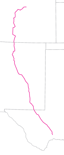
Another example is U.S. Route 24, which begins in Colorado and heads east to Ohio.  The highway is signed east-west in those two states, as well as every state in between (red on the map below).  But in the Toledo area, US 24 begins heading northeast and crosses into Michigan.  In the Detroit area US 24 runs due north-south along Telegraph Road, and around Pontiac it even curves slightly back to the northwest before terminating.  As a result, Michigan DOT signposts US 24 as a north-south route (blue on the map below):
Picture
US route 24 in its entirety, from Colorado (lower left) to Michigan (upper right).
The reasons are essentially the same as those listed above for US 41 in Miami: 1.) around the Ohio-Michigan line, US 24 ceases functioning as an east-west route and begins functioning as a north-south route, never resuming an east-west direction-of-travel; and 2.) every day thousands of drivers in metro Detroit would be confused if they saw "east" and "west" signs along Telegraph Road.  Here are a few other examples:
  • In Ft. Sumner, New Mexico, directional signage along US 84 changes from east-west to north-south. 
  • In Texas' Rio Grande Valley, signage on US 83 changes from north-south to east-west. 
  • US 98 is signed east-west in Mississippi, Alabama, and Florida's panhandle; but in peninsular Florida it changes to north-south. 
  • In the state of Washington, drivers heading "North" on US 101 along the Pacific Coast will see the signs change to "East" as the highway turns inland, and then to "South" as the highway curves back down to its terminus in Olympia.
Get your copy of this epic book that commemorates the first century of the US route system!

Additional examples abound, but I trust it has been adequately illustrated that state DOTs can -- and do -- change a highway's signposted direction-of-travel when it makes sense to do so.  Now, let's go back and take another look at US 285.  In Colorado, most of US 285 serves a north-south corridor (red on the following map):
Picture
US 285 in Colorado
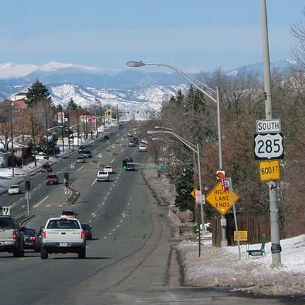
However, as the road continues north from Fairplay, right around Kenosha Pass US 285 ceases to function as a north-south route.  Instead, it begins functioning as an east-west route (blue on the maps above).  And US 285 never resumes a north-south direction-of-travel.  Rather, it ends in Denver, and in fact its final ten miles are on a nearly exact east-west alignment.

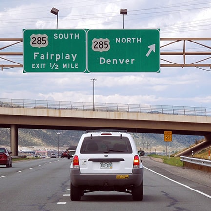
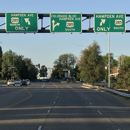
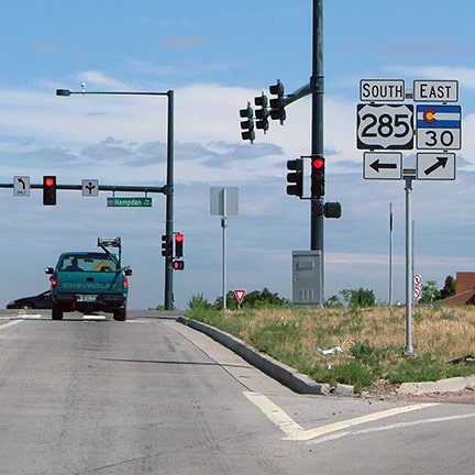
Those last ten miles are along Hampden Avenue through the Denver area.  (Well, technically US 285 bypasses Hampden in Englewood and Sheridan, but most people still refer to US 285 as "Hampden").  The Denver metro segment of US 285 handles exponentially more traffic volume than any other section of the highway.  Every day thousands of drivers come to a junction with Hampden, knowing that they want to turn either east or west, yet seeing signs only for "North" or "South" on US 285.  Just a few examples:
Picture
Northbound C-470 at US 285.
Picture
Southbound Colorado Blvd (SH 2) at Hampden.
Picture
Northbound I-25 offramp at Hampden. Right is "east" but left is "south".
Picture
Left from the preceding photo: heading due west but signed "south".

The vast majority of drivers who turn west on Hampden do not have a destination someplace in southern Colorado.  Rather, most of them have a more local destination: somewhere in the Denver area, or perhaps a bit further west, say Conifer or Bailey.  Only a very small percentage are heading anywhere beyond Kenosha Pass.  In other words: almost all of these drivers are heading west (not south).  Ask any Denverite which direction they need to go in order to reach the mountains, and they will invariably say "west".  All of this prompts the question: why should US 285 -- which heads west from Denver into the mountains -- be signposted as "South"?

It does not have to be that way.  CDOT has the authority to sign US 285 as an east-west highway between Denver and Kenosha Pass.  The precedent for this type of situation has already been established by DOTs in many other states.  Changing the directional references along this 60-mile stretch would not impact any surrounding state, because the east-west segment of US 285 is entirely insular to Colorado.  On the other hand, this change would greatly benefit untold thousands of drivers in the Denver area -- residents and visitors alike.  For the overwhelming majority of people using US 285 around Denver, it would be much less confusing to have the highway signposted as an east-west route.
5 Comments
Denver driver
6/28/2021 08:32:39 pm

Thank you for your post! I have often thought that these signs are terribly confusing and I have gone the wrong direction more than once because the signs north and south do not tell me which way to go when I'm trying to drive east and west. I have learned to just ignore the signs since they are not helpful. Since 285 ends at Hampden, it could be resigned just for the last segment and create clarity for so many drivers! Keep up the good work!

Reply
Chris
6/29/2021 04:49:34 pm

Shouldn't the same argument apply to the westernmost end of US 24 (Buena Vista to Minturn) nearby? Signed east-west but functions as a north-south.

Reply
US Ends .com
6/29/2021 05:00:10 pm

When US 24 continued to Grand Junction, it made sense to sign it all east-west. But now that it's been truncated to Minturn, absolutely! Different article, though ;-)

Reply
Landry
8/30/2021 12:25:39 pm

Signing US-24 as N-S between Minturn and Buena Vista makes sense, though I wonder if you could reroute 285 up 24 north of Buena Vista and end 24 at BV, or reroute 24 to go further (south)west, like to US-160 at Del Norte or Cortez.

Toby
6/30/2021 07:21:35 pm

I think if you're going to change the signposted direction, you might as well change the route number too. I just don't see the point in continuing a road if its local orientation differs so much from its overall course, particularly if most people using it are turning off before it changes direction. My suggestion for 285 would be truncate it to where it intersects with CO 470 southwest of Denver, and co-sign it with 470 north to its junction with I-70. This way, 285 would continue to serve the Denver metro area, but now it would be heading north, not east, at its north end.

Reply

Your comment will be posted after it is approved.


Leave a Reply.

    RSS Feed

    Author

    This guy.

    Categories

    All
    Alabama
    Arizona
    Boston
    California
    Colorado
    Denver
    Florida
    Geo-center
    Geography
    Historic
    Idaho
    Illinois
    Indiana
    Kansas
    Kentucky
    Maryland
    Massachusetts
    Michigan
    Midpoint
    Mileage
    Minnesota
    Missouri
    Nebraska
    New Hampshire
    New Jersey
    New Mexico
    Newport
    New York
    North Carolina
    North Dakota
    Numbering
    Oddity
    Ohio
    Oklahoma
    Oregon
    Pennsylvania
    Proposed
    Renumbering
    Signage
    South Carolina
    South Dakota
    Tennessee
    Texas
    Updates
    US 101
    US 127
    US 13
    US 136
    US 150
    US 154
    US 16
    US 160
    US 163
    US 164
    US 169
    US 177
    US 180
    US 183
    US 190
    US 191
    US 20
    US 210
    US 212
    US 218
    US 220
    US 23
    US 231
    US 24
    US 241
    US 25
    US 259
    US 26
    US 266
    US 27
    US 270
    US 271
    US 277
    US 281
    US 283
    US 285
    US 287
    US 3
    US 31
    US 311
    US 321
    US 331
    US 34
    US 36
    US 360
    US 371
    US 377
    US 383
    US 385
    US 40
    US 400
    US 411
    US 431
    US 450
    US 46
    US 48
    US 491
    US 50
    US 530
    US 55
    US 59
    US 6
    US 60
    US 61
    US 62
    US 63
    US 65
    US 66
    US 666
    US 67
    US 730
    US 74
    US 77
    US 80
    US 81
    US 83
    US 84
    US 85
    US 87
    US 89
    US 93
    US 94
    US 96
    US 99
    Utah
    Virginia
    Washington
    Watersheds
    West Virginia
    Wyoming

    Archives

    April 2025
    July 2024
    August 2023
    May 2023
    March 2023
    February 2023
    January 2023
    August 2022
    March 2022
    February 2022
    January 2022
    August 2021
    July 2021
    June 2021
    April 2021
    February 2021
    January 2021
    August 2020
    July 2020
    May 2020
    April 2020
    March 2020
    February 2020
    January 2020
    December 2019
    October 2019
    September 2019
    August 2019
    May 2019
    January 2019
    November 2018
    June 2018
    April 2018
    March 2018
    November 2017
    September 2017
    August 2017
    June 2017
    March 2017
    February 2017
    January 2017
    December 2016

Copyright © 1998-2025
Picture